|
Dollart
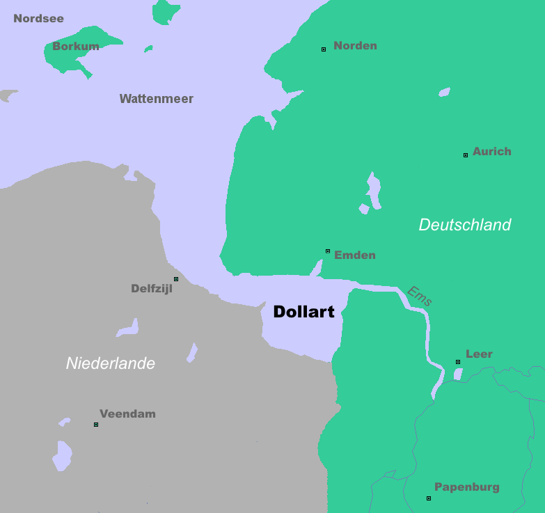
The Dollart (German name) or Dollard (Dutch name) is a bay in the Wadden Sea between the northern Netherlands and Germany, on the west side of the estuary of the Ems river. Most of it dries at low tide. Many water birds feed there. Gaining from and losing to the sea According to legend, the Dollart Bay was created by a catastrophic storm surge in 1277, covering the district of Reiderland and large parts of the Oldambt district. The flood was rumoured to have caused 80,000 deaths. The story, however, is not true and based on legend instead of facts. The Dollart was created as a slow inundation over many centuries which accumulated in a storm surge in 1509. The 1509 surge extended the Dollart, and flooded 30 more villages, and by 1520 the Dollart had its largest extension. Between the 16th and the 20th centuries, two thirds of the drowned area was reclaimed again. Nowadays the unembanked forelands have been declared world natural heritage, as they are a paradise for all k ... [...More Info...] [...Related Items...] OR: [Wikipedia] [Google] [Baidu] |
Ems (river)
The Ems (german: Ems; nl, Eems) is a river in northwestern Germany. It runs through the states of North Rhine-Westphalia and Lower Saxony, and discharges into the Dollart Bay which is part of the Wadden Sea. Its total length is . The state border between the Lower Saxon area of East Friesland (Germany) and the province of Groningen (Netherlands), whose exact course was the subject of a border dispute between Germany and the Netherlands (settled in 2014), runs through the Ems estuary. Course The source of the river is in the southern Teutoburg Forest in North Rhine-Westphalia. In Lower Saxony, the brook becomes a comparatively large river. Here the swampy region of Emsland is named after the river. In Meppen the Ems is joined by its largest tributary, the Hase River. It then flows northwards, close to the Dutch border, into East Frisia. Near Emden, it flows into the Dollart bay (a national park) and then continues as a tidal river towards the Dutch city of Delfzijl. Betwee ... [...More Info...] [...Related Items...] OR: [Wikipedia] [Google] [Baidu] |
Germany–Netherlands Border
The Germany–Netherlands border (; ) consists of a land and maritime border across the Dollart through the Frisian Islands into the North Sea. Land border The border is located in the northwestern part of Germany and the east of the Netherlands. The border runs as a fairly irregular line from the shore of the Dollart bay which is part of the Ems river estuary in the north to the Belgium–Germany–Netherlands tripoint at Vaalserberg. The length of the border is around in length, although the straight distance between the two border end points is . The border runs along portions of rivers, including for along the large Rhine river. It also runs for about along the Meuse valley, although most of the time a few kilometres to the east of the Meuse river rather than along it, before leaving the valley at the last portion of border to the border tripoint located at Vaalserberg about west of Aachen. The German states which share the international border are (from north to s ... [...More Info...] [...Related Items...] OR: [Wikipedia] [Google] [Baidu] |
Estuary
An estuary is a partially enclosed coastal body of brackish water with one or more rivers or streams flowing into it, and with a free connection to the open sea. Estuaries form a transition zone between river environments and maritime environments and are an example of an ecotone. Estuaries are subject both to marine influences such as tides, waves, and the influx of saline water, and to fluvial influences such as flows of freshwater and sediment. The mixing of seawater and freshwater provides high levels of nutrients both in the water column and in sediment, making estuaries among the most productive natural habitats in the world. Most existing estuaries formed during the Holocene epoch with the flooding of river-eroded or glacially scoured valleys when the sea level began to rise about 10,000–12,000 years ago. Estuaries are typically classified according to their geomorphological features or to water-circulation patterns. They can have many different names, such as bays, ... [...More Info...] [...Related Items...] OR: [Wikipedia] [Google] [Baidu] |
Reiderland
Reiderland () is a former municipality in the province Groningen in the northeastern Netherlands, which was founded in 1990 during a large municipal reorganisation. The former municipalities Finsterwolde and Bad Nieuweschans were abolished and added to Beerta. In 1992, the new municipality was given its current name. In 2010 it joined in the municipality Oldambt. Politics Reiderland was one of the few municipalities in the Netherlands that still had communist councillors after the dissolution of the Communist Party of the Netherlands in 1989. (As of 2006, it was one of only four Dutch municipalities to have any, the other three being Heiloo, Scheemda and Lemsterland.) The New Communist Party of the Netherlands was in fact the largest party in Reiderland from 1990 to 1998 and again from 2002 to 2006. Finsterwolde and Beerta, which was the only town in the Netherlands that ever had a communist mayor, had long been communist strongholds. In the 1998 municipal election, the New Comm ... [...More Info...] [...Related Items...] OR: [Wikipedia] [Google] [Baidu] |
Borkum Riffgat
Riffgat (also known as Borkum Riffgat and OWP Riffgat) is an offshore wind farm to the north-west of the German island of Borkum and north of the eponymous shipping channel in the southern North Sea. The wind turbines are built across an area of . It consists of 30 turbines with a total capacity of 108 megawatt (MW), and is expected to generate enough electricity for 112,000 households. Early 2011, the Dutch government stated that the wind farm was partly in Dutch territory and protested against the issuing of construction licenses by the German government. The issue was resolved in 2014 with the signing of the Ems-Dollart-Treaty. Between November 2015 and April 2016, transmission problems prevented Riffgat from exporting power. See also *Wind power in Germany *List of Offshore Wind Farms This article lists the largest offshore wind farms that are currently operational rated by nameplate capacity. It also lists the largest offshore wind farms curren ... [...More Info...] [...Related Items...] OR: [Wikipedia] [Google] [Baidu] |
Territorial Dispute
A territorial dispute or boundary dispute is a disagreement over the possession or control of land between two or more political entities. Context and definitions Territorial disputes are often related to the possession of natural resources such as rivers, fertile farmland, mineral or petroleum resources although the disputes can also be driven by culture, religion, and ethnic nationalism. Territorial disputes often result from vague and unclear language in a treaty that set up the original boundary. Territorial disputes are a major cause of wars and terrorism, as states often try to assert their sovereignty over a territory through invasion, and non-state entities try to influence the actions of politicians through terrorism. International law does not support the use of force by one state to annex the territory of another state. ThUN Charterstates, "All Members shall refrain in their international relations from the threat or use of force against the territorial integrity or ... [...More Info...] [...Related Items...] OR: [Wikipedia] [Google] [Baidu] |
Bodies Of Water Of Groningen (province)
Bodies may refer to: * The plural of Body (other), body * Bodies (2004 TV series), ''Bodies'' (2004 TV series), BBC television programme * Bodies (upcoming TV series), an upcoming British crime thriller limited series * Bodies (Law & Order), "Bodies" (''Law & Order''), 2003 episode of ''Law & Order'' * Bodies: The Exhibition, exhibit showcasing dissected human bodies in cities across the globe * Bodies (novel), ''Bodies'' (novel), 2002 novel by Jed Mercurio * ''Bodies'', 1977 play by James Saunders (playwright) * ''Bodies'', 2009 book by British psychoanalyst Susie Orbach Music * Bodies (album), ''Bodies'' (album), a 2021 album by AFI * Bodies (EP), ''Bodies'' (EP), a 2014 EP by Celia Pavey * Bodies (Drowning Pool song), "Bodies" (Drowning Pool song), 2001 hard rock song by Drowning Pool * Bodies (Sex Pistols song), "Bodies" (Sex Pistols song), 1977 punk rock song by the Sex Pistols * Bodies (Little Birdy song), "Bodies" (Little Birdy song), 2007 indie rock song by Lit ... [...More Info...] [...Related Items...] OR: [Wikipedia] [Google] [Baidu] |
Bays Of Lower Saxony
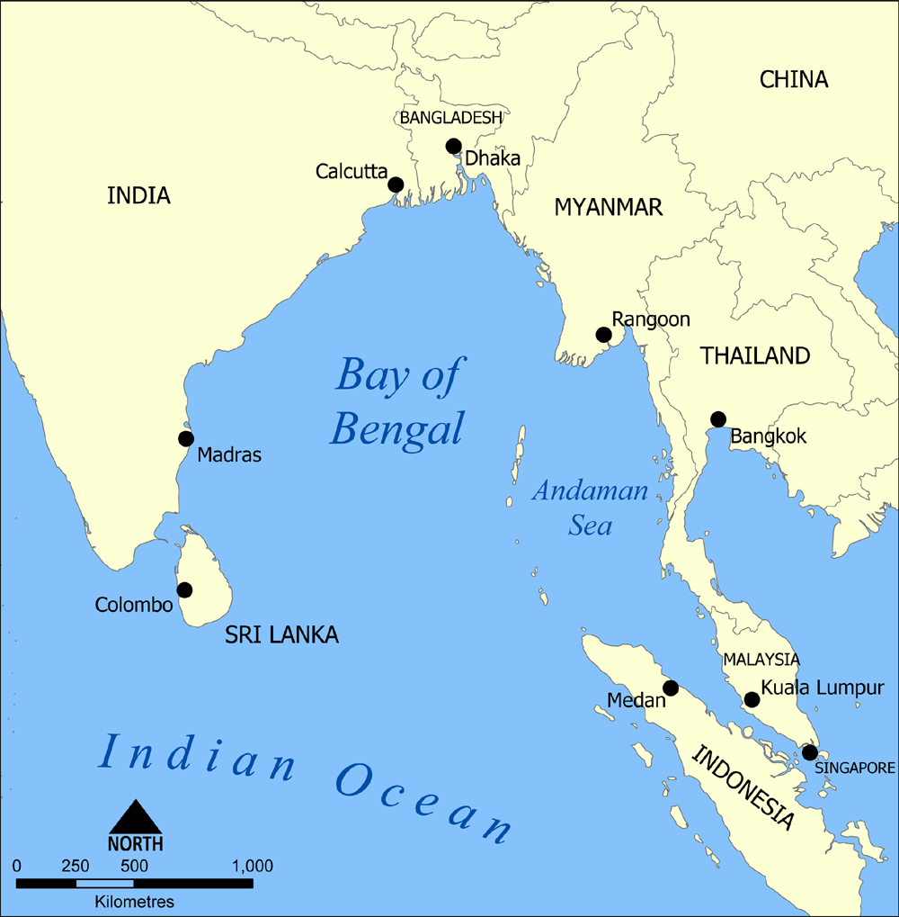
A bay is a recessed, coastal body of water that directly connects to a larger main body of water, such as an ocean, a lake, or another bay. A large bay is usually called a gulf, sea, sound, or bight. A cove is a small, circular bay with a narrow entrance. A fjord is an elongated bay formed by glacial action. A bay can be the estuary of a river, such as the Chesapeake Bay, an estuary of the Susquehanna River. Bays may also be nested within each other; for example, James Bay is an arm of Hudson Bay in northeastern Canada. Some large bays, such as the Bay of Bengal and Hudson Bay, have varied marine geology. The land surrounding a bay often reduces the strength of winds and blocks waves. Bays may have as wide a variety of shoreline characteristics as other shorelines. In some cases, bays have beaches, which "are usually characterized by a steep upper foreshore with a broad, flat fronting terrace".Maurice Schwartz, ''Encyclopedia of Coastal Science'' (2006), p. 129. Bays were s ... [...More Info...] [...Related Items...] OR: [Wikipedia] [Google] [Baidu] |
Bays Of The Netherlands
A bay is a recessed, coastal body of water that directly connects to a larger main body of water, such as an ocean, a lake, or another bay. A large bay is usually called a gulf, sea, sound, or bight. A cove is a small, circular bay with a narrow entrance. A fjord is an elongated bay formed by glacial action. A bay can be the estuary of a river, such as the Chesapeake Bay, an estuary of the Susquehanna River. Bays may also be nested within each other; for example, James Bay is an arm of Hudson Bay in northeastern Canada. Some large bays, such as the Bay of Bengal and Hudson Bay, have varied marine geology. The land surrounding a bay often reduces the strength of winds and blocks waves. Bays may have as wide a variety of shoreline characteristics as other shorelines. In some cases, bays have beaches, which "are usually characterized by a steep upper foreshore with a broad, flat fronting terrace".Maurice Schwartz, ''Encyclopedia of Coastal Science'' (2006), p. 129. Bays were sig ... [...More Info...] [...Related Items...] OR: [Wikipedia] [Google] [Baidu] |
Frank Westerman
Frank Martin Westerman (born 13 November 1964) is a Dutch writer and a former journalist. He studied tropical agricultural engineering at Wageningen University and worked as a news correspondent for ''de Volkskrant'' in Belgrade and ''NRC Handelsblad'' in Moscow. He is currently a full-time writer of non-fiction books, among which are ''The Republic of Grain'' (1999), ''Engineers of the Soul'' (2002), and ''Ararat'' (2007). Life Frank Martin Westerman was born on 13 November 1964 in Emmen in the Netherlands. He grew up in Assen, in a Christian-reformed family. Westerman studied tropical agricultural engineering at the Agricultural University of Wageningen. In 1987, he travelled to Peru, where he did research in Puno. In this period, he also started working as a journalist. In 1992, he became correspondent of ''de Volkskrant'' in Belgrade. In 1995, Westerman and his colleague were two of the few journalists who were in Srebrenica during its capture. The book ''Srebrenica: The ... [...More Info...] [...Related Items...] OR: [Wikipedia] [Google] [Baidu] |
Nautical Mile
A nautical mile is a unit of length used in air, marine, and space navigation, and for the definition of territorial waters. Historically, it was defined as the meridian arc length corresponding to one minute ( of a degree) of latitude. Today the international nautical mile is defined as exactly . The derived unit of speed is the knot, one nautical mile per hour. Unit symbol There is no single internationally agreed symbol, with several symbols in use. * M is used as the abbreviation for the nautical mile by the International Hydrographic Organization. * NM is used by the International Civil Aviation Organization. * nmi is used by the Institute of Electrical and Electronics Engineers and the United States Government Publishing Office. * nm is a non-standard abbreviation used in many maritime applications and texts, including U.S. Government Coast Pilots and Sailing Directions. It conflicts with the SI symbol for nanometre. History The word mile is from the Latin word ... [...More Info...] [...Related Items...] OR: [Wikipedia] [Google] [Baidu] |


