|
Deogyusan
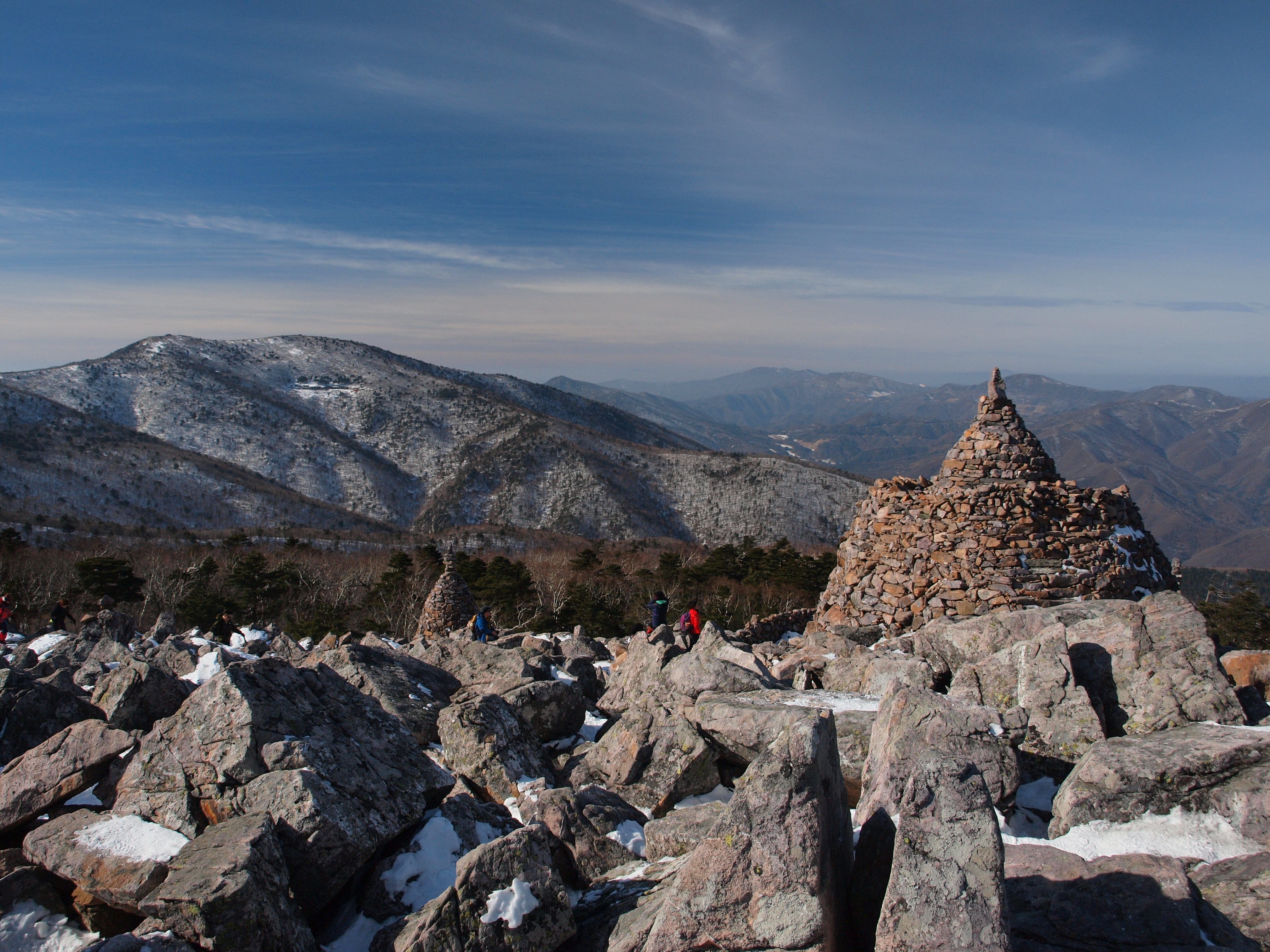
Deogyusan, formerly spelled Togyusan, is a mountain in South Korea. Its highest peak is 1,614 meters above sea level. Geography Deogyusan stands on the border of Jeollabuk-do and Gyeongsangnam-do, covering portions of Muju County, Muju and Jangsu Counties in Jeollabuk-do and Geochang and Hamyang Counties in Gyeongsangnam-do.An 2003, p.111. Deogyusan stands on the Baekdudaegan, the mountainous spine of the Korean Peninsula. It is composed of numerous ridges which rise to various local peaks; the highest (by which the mountain's elevation is measured) is ''Hyangjeokbong''. Attractions Deogyusan is the cornerstone of Deogyusan National Park, established 1975. The attractions of the park include the Chiryeon Waterfall and Cheoksan mountain fortress. It is also famous for the winter ski resort of Muju Resort, Muju. Animal and plant life Approximately 250 animal species and 600 plant species are found in the Deogyusan area. An Amur Leopard was shot on Deogyusan in 1960, a few y ... [...More Info...] [...Related Items...] OR: [Wikipedia] [Google] [Baidu] |
Deogyusan National Park
Deogyusan National Park ( ko, 덕유산국립공원, 德裕山國立公園) is located in the provinces of Jeollabuk-do and Gyeongsangnam-do, South Korea. It was designated as the 10th national park in 1975. The park is home to a total of 1,067 plant species, 32 mammal species, 130 bird species, 9 amphibian species, 13 reptile species, 28 fish species, and 1,337 insect species. Endangered animals in the park include Flying squirrel, Marten and Otter. See also *Deogyusan References External linksThe park's page on Korea National Park Service's website National parks of South Korea Protected areas established in 1984 Parks in North Jeolla Province Parks in South Gyeongsang Province {{Protected-area-stub ... [...More Info...] [...Related Items...] OR: [Wikipedia] [Google] [Baidu] |
Muju County
Muju County (''Muju-gun''), is a county in North Jeolla Province (Jeollabuk-do), South Korea. Muju is known for its Muju Firefly Festival and is a tourist area. History During the era of the Three Kingdoms of Korea, Mupung (the present name) in Byeonjin belonged to Silla and was called ''Musanhyeon'', and Jugye area (current Muju-eup) in Mahan belonged to Baekje and was called ''Jeokcheonhyeon''. It is known that Musan was renamed as ''Mupung'' and Jeokcheon as ''Dancheon'' after the Era of Unified Silla (668~917). After Goryeo (918~1392) was founded, Mupung did not change its name whereas Dancheon was renamed as ''Jugye'', and as Joseon rearranged administrative districts in 1414 (the 14th year of Taejong), Mupung and Jugye were incorporated into one district. It was named as Muju through the combination of the first letters of the two areas, Mupung and Jugye, after they were incorporated into one administrative district. Geography Muju-gun is situated near four provinces, inc ... [...More Info...] [...Related Items...] OR: [Wikipedia] [Google] [Baidu] |
National Parks Of South Korea
The national parks of South Korea are preserved parcels of public land on which most forms of development are prohibited. They cover a total of 6.6% of the country's area, and are typically located in mountainous or coastal regions. The country's largest mountain park is Jirisan National Park in the southwest; this was also the first national park to be designated in 1967. The largest marine park is Dadohaehaesang, with an area of more than , but almost all of this is water. The smallest park is Wolchulsan, with an area of only . As of 2016, there are 22 national parks in South Korea; the parks, with the exception of Hallasan National Park, are managed by the Korea National Park Service, established in 1987. The Authority operates its own police force, and since 1998 has been under the jurisdiction of the Ministry of Environment. It was previously under the jurisdiction of the Ministry of Construction. History Early on, admission to national parks in South Korea was free. In ... [...More Info...] [...Related Items...] OR: [Wikipedia] [Google] [Baidu] |
Muju Resort
Muju Resort (무주리조트), officially Muju Deogyusan Resort (무주덕유산리조트) is a ski resort in Muju, South Korea. It is located on the north face of the Seolcheon Peak at an elevation of above sea level on the Deogyu Mountain. Also located in the Deogyu Mountain National Park, it is the only ski resort in South Korea situated in national park. The resort is one of the largest ski resorts in South Korea. It has the second-highest vertical drop in South Korea after the 2018 Winter Olympic downhill slopes and the highest vertical drop of the commercial resorts. History The resort was opened on December 22, 1990 by Ssangbangwool Group. When it opened, the ski slopes only included the Manseon Peak, the western-half of the current slopes. For the 1997 Winter Universiade, the resort completed the ski jumping hills on September 16, 1996. It subsequently completed the Seolcheon Peak slopes and Nordic ski area together on December 5, 1996. See also * Jumping Park ... [...More Info...] [...Related Items...] OR: [Wikipedia] [Google] [Baidu] |
List Of Mountains Of Korea
The following is a list of mountain A mountain is an elevated portion of the Earth's crust, generally with steep sides that show significant exposed bedrock. Although definitions vary, a mountain may differ from a plateau in having a limited Summit (topography), summit area, and ...s in Korea: List of mountains in North Korea Pyeongyang * Taesongsan (대성산; ) – Chagang Province * Namsan (Chagang), Namsan (남산; ) – * Obongsan (Chagang), Obongsan (오봉산; ) – North Pyongan Province * Myohyangsan (묘향산; ) – South Hwanghae Province * Kuwolsan (구월산; ) – * Maebongsan (South Hwanghae), Maebongsan (매봉산; ) – * Namsan (Haeju), Namsan (남산; ) – * Namsan (Unnyul), Namsan (남산; ) – Kangwon Province * Mount Kumgang, Kumgangsan (금강산; ) – * Maebongsan (Poptong), Maebongsan (매봉산; ) – * Obongsan (Kosong–Kumgang), Obongsan (오봉산; ) – South Hamgyong Province * Madaesan (South Hamgyong), Madaesan (마대� ... [...More Info...] [...Related Items...] OR: [Wikipedia] [Google] [Baidu] |
Mountains Of South Korea
The following is a list of mountains in Korea: List of mountains in North Korea Pyeongyang * Taesongsan (대성산; ) – Chagang Province * Namsan (남산; ) – * Obongsan (오봉산; ) – North Pyongan Province * Myohyangsan (묘향산; ) – South Hwanghae Province * Kuwolsan (구월산; ) – * Maebongsan (매봉산; ) – * Namsan (남산; ) – * Namsan (남산; ) – Kangwon Province * Kumgangsan (금강산; ) – * Maebongsan (매봉산; ) – * Obongsan (오봉산; ) – South Hamgyong Province * Madaesan (마대산; ) – * Obongsan (오봉산; ) – North Hamgyong Province * Chilbosan (칠보산; ) – * Mantapsan (만탑산; ) – Ryanggang Province * Paektusan (백두산; ) – , the tallest mountain in North Korea and the Korean Peninsula altogether. List of mountains in South Korea Seoul * Achasan (아차산;) – * Ansan (Seoul) (안산;) - * Bukhansan (북한산; ) – An 2003, p.232. * Buramsan (불암산; ) – Yu 20 ... [...More Info...] [...Related Items...] OR: [Wikipedia] [Google] [Baidu] |
Baekdudaegan
The Baekdu-daegan is a mountain-system and watershed-crest-line which runs through almost all of the length of the Korean Peninsula, from Paektu Mountain (2,744m) in the north to the Cheonhwang-bong or "Heavenly Monarch Peak" of Jirisan (1,915m) in the south. It has 13 Jeongmaek or branch-ranges that begin on the mainline range and channel Korea's biggest rivers to the east, west and south seas. The Baekdu-daegan is important in traditional Korean geography and thought, a key aspect of Pungsujiri philosophy and practices. It is often referred to as the "spine" or "backbone" of the Korean Peninsula, and depicted in various historic and modern artworks including national maps. Under traditional Korean thought influenced by Daoism and Neo-Confucianism, Mt. Baekdu-san is regarded as the northern root-origin of the mountain-system, and conceived-of as the grand patriarch of all Korean mountains; while Jiri-san at the southern end is conceived-of as the grand matriarch of all Ko ... [...More Info...] [...Related Items...] OR: [Wikipedia] [Google] [Baidu] |
Jeollabuk-do
North Jeolla Province (; ''Jeollabuk-do''), also known as Jeonbuk, is a province of South Korea. North Jeolla has a population of 1,869,711 (2015) and has a geographic area of 8,067 km2 (3,115 sq mi) located in the Honam region in the southwest of the Korean Peninsula. North Jeolla borders the provinces of South Jeolla to the south, North Gyeongsang and South Gyeongsang to the east, North Chungcheong to the northeast, and South Chungcheong to the north. Jeonju is the capital and largest city of North Jeolla, with other major cities including Iksan, Gunsan, and Jeongeup. North Jeolla was established in 1896 from the province of Jeolla, one of the Eight Provinces of Korea, consisting of the northern half of its mainland territory. History During the Proto-Three Kingdoms period, Jeolla region was the center of the Mahan confederacy among Samhan. There were 15 tribal countries out of 54 in the region. During the period of the Three States, this region came to belong to Baekje w ... [...More Info...] [...Related Items...] OR: [Wikipedia] [Google] [Baidu] |
Hamyang County
Hamyang County (''Hamyang-gun'') is a county in South Gyeongsang Province, South Korea. It is home to the Wooden Seated Statue of Buddha in Beopinsa (법인사), the Standing Statue of Buddha in Deokjeonri (덕전리), the Three-Level Stone Pagoda, Stone Seated Statue of Buddha, Three Storied Stone Pagoda of Seungansa (승안사) Temple Site. There are also historical sites such as the Namgyeseowon (남계서원) Confucian School, Hwangseoksanseong (황석산성) Fortress, and Sageunsanseong (사근산성) Fortress. History Three Kingdoms Period The Sageunsanseong Fortress, which encircles the peak of Yeonhwasan Mountain (443 m above sea level) is presumed to have been built during the Three Kingdoms of Korea (57 BCE-668 CE) and used until the Joseon period (1392-1910). The fortress was located at a strategic pass and was therefore a site of fierce conflicts between the Baekje Kingdom (18 BCE-660 CE) to the west and the Silla Kingdom (57 BCE-935 CE) to the east. The fortress a ... [...More Info...] [...Related Items...] OR: [Wikipedia] [Google] [Baidu] |
Geochang County
Geochang County (''Geochang-gun,'' ) is a county in South Gyeongsang Province, South Korea. The Geochang International Festival of Theater, which was started in 1989, is renowned as the best play festival in Korea. The District Office is located in Geochang-eup, and has jurisdiction over 1 eup and 11 myeon. The origin of Geochang's name Geocheang Country ( Geochang-gun, Korean pronunciation) has been called ''Geoyeol'', ''Geota'' and ''Arim'' since ancient times, in the meaning of a large bright place, a very wide field, a wide field, or a large bright one. It was first called a Geochang in the 16th year of King Gyeongdeok of Silla in 757 and was called a geochang after being divided and annexed by surrounding cities. History *At the beginning of the Shilla Dynasty was referred to as Gayeol. *1896 Gyeongsangnam-do, Geochang-gun *1928 Gadong-myeon and Gaseo-myeon consolidated into Gajo-myeon. *1931 Eupwoe-myeon renamed to Wolcheon-myeon. *1937 Geochang-myeon elevated to G ... [...More Info...] [...Related Items...] OR: [Wikipedia] [Google] [Baidu] |
Jangsu County
Jangsu County (''Jangsu-gun'') is a county in North Jeolla Province, South Korea. It is well known for Jangsu-Galbi. Climate Twin towns – sister cities Jangsu is twinned with: * Anyang, South Korea (1996) * Hapcheon, South Korea (1999) * Jinhae-gu, South Korea South Korea, officially the Republic of Korea (ROK), is a country in East Asia, constituting the southern part of the Korea, Korean Peninsula and sharing a Korean Demilitarized Zone, land border with North Korea. Its western border is formed ... (1999) References External links County government home page (in English)County government home page (in Korean) {{coord, 35.6463888989, N, 127.519444454, E, source:ruwiki_region:KR_type:city(26463), format=dms, display=title Counties of North Jeolla Province ... [...More Info...] [...Related Items...] OR: [Wikipedia] [Google] [Baidu] |
Mountains Of North Jeolla Province
A mountain is an elevated portion of the Earth's crust, generally with steep sides that show significant exposed bedrock. Although definitions vary, a mountain may differ from a plateau in having a limited summit area, and is usually higher than a hill, typically rising at least 300 metres (1,000 feet) above the surrounding land. A few mountains are isolated summits, but most occur in mountain ranges. Mountains are formed through tectonic forces, erosion, or volcanism, which act on time scales of up to tens of millions of years. Once mountain building ceases, mountains are slowly leveled through the action of weathering, through slumping and other forms of mass wasting, as well as through erosion by rivers and glaciers. High elevations on mountains produce colder climates than at sea level at similar latitude. These colder climates strongly affect the ecosystems of mountains: different elevations have different plants and animals. Because of the less hospitable terrain and ... [...More Info...] [...Related Items...] OR: [Wikipedia] [Google] [Baidu] |


