|
Denning (Martian Crater)
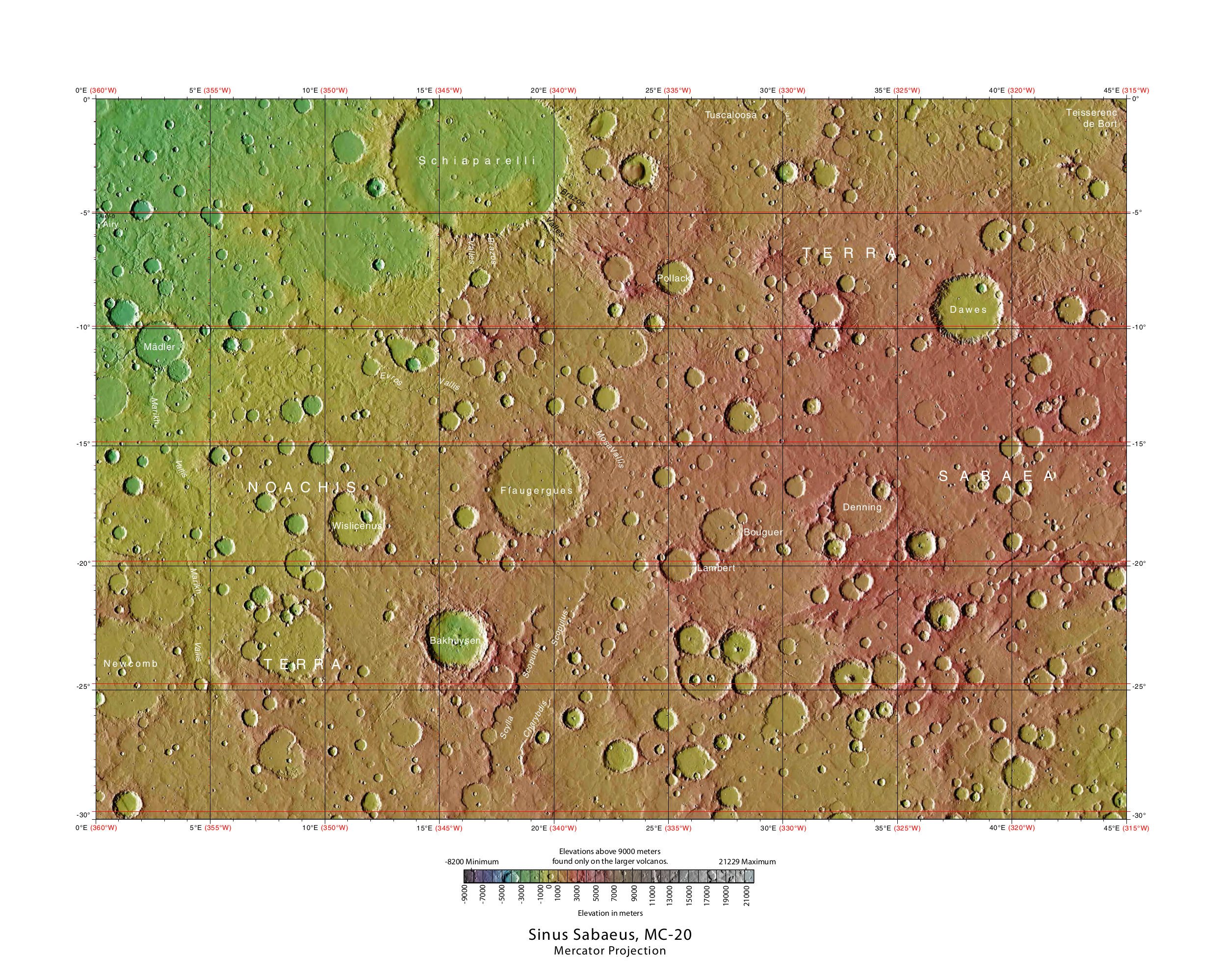
Denning Crater is a large Noachian-age impact crater in the southwestern Terra Sabaea region of the southern Martian highlands, within the Sinus Sabaeus quadrangle. It is located to the northwest of the Hellas impact basin within the furthest outskirts of the Hellas debris apron. The crater is 165 km in diameter and likely formed during the Late Heavy Bombardment, a period of intense bolide impacts affecting the entirety of the Solar System; during the Hesperian period, aeolian processes caused significant degradation of the crater's rim features and infilled the crater's floor (which is nearly at the same elevation as the surrounding plains terrain). Similar to other large craters in this region of Mars, wind-eroded features are sporadically found on the basin floor. The presence of wrinkle ridges of varying orientations within and around the Denning basin has been correlated to regional tectonic events, including the formation of the Hellas basin itself. The crate ... [...More Info...] [...Related Items...] OR: [Wikipedia] [Google] [Baidu] |
Sinus Sabaeus Quadrangle
The Sinus Sabaeus quadrangle is one of a series of 30 quadrangle maps of Mars used by the United States Geological Survey (USGS) Astrogeology Research Program. It is also referred to as MC-20 (Mars Chart-20). The Sinus Sabaeus quadrangle covers the area from 315° to 360° west longitude and 0° to 30° degrees south latitude on Mars. It contains Schiaparelli, a large, easily visible crater that sits close to the equator. The Sinus Sabaeus quadrangle contains parts of Noachis Terra and Terra Sabaea. The name comes from an incense-rich location south of the Arabian peninsula (the Gulf of Aden). Layers Wislicenus Crater and the Schiaparelli basin crater contains layers, also called strata. Many places on Mars show rocks arranged in layers.Grotzinger, J. and R. Milliken (eds.) 2012. Sedimentary Geology of Mars. SEPM Sometimes the layers are of different colors. Light-toned rocks on Mars have been associated with hydrated minerals like sulfates. The Mars rove ... [...More Info...] [...Related Items...] OR: [Wikipedia] [Google] [Baidu] |
Weathering
Weathering is the deterioration of rocks, soils and minerals as well as wood and artificial materials through contact with water, atmospheric gases, and biological organisms. Weathering occurs ''in situ'' (on site, with little or no movement), and so is distinct from erosion, which involves the transport of rocks and minerals by agents such as water, ice, snow, wind, waves and gravity. Weathering processes are divided into ''physical'' and ''chemical weathering''. Physical weathering involves the breakdown of rocks and soils through the mechanical effects of heat, water, ice, or other agents. Chemical weathering involves the chemical reaction of water, atmospheric gases, and biologically produced chemicals with rocks and soils. Water is the principal agent behind both physical and chemical weathering, though atmospheric oxygen and carbon dioxide and the activities of biological organisms are also important. Chemical weathering by biological action is also known as biological wea ... [...More Info...] [...Related Items...] OR: [Wikipedia] [Google] [Baidu] |
United States Geological Survey
The United States Geological Survey (USGS), formerly simply known as the Geological Survey, is a scientific agency of the United States government. The scientists of the USGS study the landscape of the United States, its natural resources, and the natural hazards that threaten it. The organization's work spans the disciplines of biology, geography, geology, and hydrology. The USGS is a fact-finding research organization with no regulatory responsibility. The agency was founded on March 3, 1879. The USGS is a bureau of the United States Department of the Interior; it is that department's sole scientific agency. The USGS employs approximately 8,670 people and is headquartered in Reston, Virginia. The USGS also has major offices near Lakewood, Colorado, at the Denver Federal Center, and Menlo Park, California. The current motto of the USGS, in use since August 1997, is "science for a changing world". The agency's previous slogan, adopted on the occasion of its hundredt ... [...More Info...] [...Related Items...] OR: [Wikipedia] [Google] [Baidu] |
Complex Crater
Complex craters are a type of large impact crater morphology. Above a certain threshold size, which varies with planetary gravity, the collapse and modification of the transient cavity is much more extensive, and the resulting structure is called a ''complex crater''. The collapse of the transient cavity is driven by gravity, and involves both the uplift of the central region and the inward collapse of the rim. The central uplift is not the result of ''elastic rebound'' which is a process in which a material with elastic strength attempts to return to its original geometry; rather the uplift is a process in which a material with little or no strength attempts to return to a state of gravitational equilibrium. Complex craters have uplifted centers, and they have typically broad flat shallow crater floors, and terraced walls. At the largest sizes, one or more exterior or interior rings may appear, and the structure may be labeled an ''impact basin'' rather than an impact crater. ... [...More Info...] [...Related Items...] OR: [Wikipedia] [Google] [Baidu] |
Mars Reconnaissance Orbiter
''Mars Reconnaissance Orbiter'' (MRO) is a spacecraft designed to study the geology and climate of Mars, provide reconnaissance of future landing sites, and relay data from surface missions back to Earth. It was launched on August 12, 2005, and reached Mars on March 10, 2006. In November 2006, after five months of aerobraking, it entered its final science orbit and began its primary science phase. The cost to develop and operate MRO through the end of its prime mission in 2010 was . The spacecraft continues to operate at Mars, far beyond its intended design life. Due to its critical role as a high-speed data-relay for ground missions, NASA intends to continue the mission as long as possible, at least through the late 2020s. Pre-launch After the twin failures of the ''Mars Climate Orbiter'' and the Mars Polar Lander missions in 1999, NASA reorganized and replanned its Mars Exploration Program. In October 2000, NASA announced its reformulated Mars plans, which reduced the numb ... [...More Info...] [...Related Items...] OR: [Wikipedia] [Google] [Baidu] |
Thermal Emission Imaging System
The Thermal Emission Imaging System (THEMIS) is a camera on board the 2001 Mars Odyssey orbiter. It images Mars in the visible and infrared parts of the electromagnetic spectrum in order to determine the thermal properties of the surface and to refine the distribution of minerals on the surface of Mars as determined by the Thermal Emission Spectrometer (TES). Additionally, it helps scientists to understand how the mineralogy of Mars relates to its landforms, and it can be used to search for thermal hotspots in the Martian subsurface. THEMIS is managed from the Mars Space Flight Facility at Arizona State University and was built by the Santa Barbara Remote Sensing division of Raytheon Technologies Corporation, an American multinational conglomerate headquartered in Waltham, Massachusetts. The instrument is named after Themis, the goddess of justice in ancient Greek mythology. Infrared camera THEMIS detects thermal infrared energy emitted by the Martian surface at nine di ... [...More Info...] [...Related Items...] OR: [Wikipedia] [Google] [Baidu] |
Perturbation (geology)
Perturbation (from Latin: ''perturbare'' "to confuse, disorder, disturb", from ''per''- "through" + ''turbare'' "disturb, confuse," from ''turba'' "turmoil, crowd") is a set of pedology (soil study) and sedimentary geology processes relating to changes in the nature of water-borne alluvial sediments and ''in situ'' soil deposits over time. * Pedoturbation (from Greek: πέδον (''pédon''), "soil") involves mixing between soil horizons, and is an important factor in soil formation. Pedoturbation includes churning clays, cryoturbation, and bioturbation. Types of bioturbation include faunal pedoturbation (animal burrowing), and floral pedoturbation (root growth, tree-uprootings). Pedoturbation transforms soils through destratification, mixing, and sorting, as well as creating preferential flow paths for soil gas and infiltrating water. The zone of active bioturbation is termed the soil biomantle. * Soil perturbation that is not pedoturbation. Precipitation of surface sal ... [...More Info...] [...Related Items...] OR: [Wikipedia] [Google] [Baidu] |
Rim (craters)
The rim or edge of an impact crater is the part that extends above the height of the local surface, usually in a circular or elliptical pattern. In a more specific sense, the rim may refer to the circular or elliptical edge that represents the uppermost tip of this raised portion. If there is no raised portion, the rim simply refers to the inside edge of the curve where the flat surface meets the curve of the crater bottom. Simple craters Smaller, simple craters retain rim geometries similar to the features of many craters found on the Moon and the planet Mercury. Complex craters Large craters are those with a diameter greater than 2.3 km, and are distinguished by central uplifts within the impact zone. These larger (also called “complex”) craters can form rims up to several hundred meters in height. A process to consider when determining the exact height of a crater rim is that melt may have been pushed over the crest of the initial rim from the initial impact, ther ... [...More Info...] [...Related Items...] OR: [Wikipedia] [Google] [Baidu] |
Country Rock (geology)
In geology, country rock is the rock native to an area, in contrast to any intrusion of viscous geologic material, commonly magma, or perhaps rock salt (in salt domes) or unconsolidated sediments. Magma is typically less dense than the rock it intrudes, widening and filling existing cracks, sometimes melting the already-existing country rock. The term "country rock" is similar to, and in many cases interchangeable with, the terms basement and wall rocks. Country rock can denote the widespread lithology of a region in relation to the rock which is being discussed or observed. Geologic settings Settings in geology when the term ''country rock'' is used include: Igneous intrusions When describing a pluton or dike, the igneous rock can be described as intruding the surrounding ''country rock'', the rock into which the pluton has intruded.Newfoundland and LabradorGlossary of Geological Terms Accessed June 2018. When country rock is intruded by a dike, perpendicular to ... [...More Info...] [...Related Items...] OR: [Wikipedia] [Google] [Baidu] |
Graben
In geology, a graben () is a depressed block of the crust of a planet or moon, bordered by parallel normal faults. Etymology ''Graben'' is a loan word from German, meaning 'ditch' or 'trench'. The word was first used in the geologic context by Eduard Suess in 1883. The plural form is either ''graben'' or ''grabens''. Formation A graben is a valley with a distinct escarpment on each side caused by the displacement of a block of land downward. Graben often occur side by side with horsts. Horst and graben structures indicate tensional forces and crustal stretching. Graben are produced from parallel normal faults, where the displacement of the hanging wall is downward, while that of the footwall is upward. The faults typically dip toward the center of the graben from both sides. Horsts are parallel blocks that remain between graben; the bounding faults of a horst typically dip away from the center line of the horst. Single or multiple graben can produce a rift valley. Half-g ... [...More Info...] [...Related Items...] OR: [Wikipedia] [Google] [Baidu] |
Asthenosphere
The asthenosphere () is the mechanically weak and ductile region of the upper mantle of Earth. It lies below the lithosphere, at a depth between ~ below the surface, and extends as deep as . However, the lower boundary of the asthenosphere is not well defined. The asthenosphere is almost solid, but a slight amount of melting (less than 0.1% of the rock) contributes to its mechanical weakness. More extensive decompression melting of the asthenosphere takes place where it wells upwards, and this is the most important source of magma on Earth. It is the source of mid-ocean ridge basalt (MORB) and of some magmas that erupted above subduction zones or in regions of continental rifting. Characteristics The asthenosphere is a part of the upper mantle just below the lithosphere that is involved in plate tectonic movement and isostatic adjustments. It is composed of peridotite, a rock containing mostly the minerals olivine and pyroxene. The lithosphere-asthenosphere boundary is con ... [...More Info...] [...Related Items...] OR: [Wikipedia] [Google] [Baidu] |
Stratigraphic Unit
A stratigraphic unit is a volume of rock of identifiable origin and relative age range that is defined by the distinctive and dominant, easily mapped and recognizable petrographic, lithologic or paleontologic features (facies) that characterize it. Units must be ''mappable'' and ''distinct'' from one another, but the contact need not be particularly distinct. For instance, a unit may be defined by terms such as "when the sandstone component exceeds 75%". Lithostratigraphic units Sequences of sedimentary and volcanic rocks are subdivided the basis of their shared or associated lithology. Formally identified lithostratigraphic units are structured in a hierarchy of lithostratigraphic rank, higher rank units generally comprising two or more units of lower rank. Going from smaller to larger in rank, the main lithostratigraphic ranks are Bed, Member, Formation, Group and Supergroup. Formal names of lithostratigraphic units are assigned by geological surveys. Units of formation or hi ... [...More Info...] [...Related Items...] OR: [Wikipedia] [Google] [Baidu] |


