|
Delchevo, Blagoevgrad Province
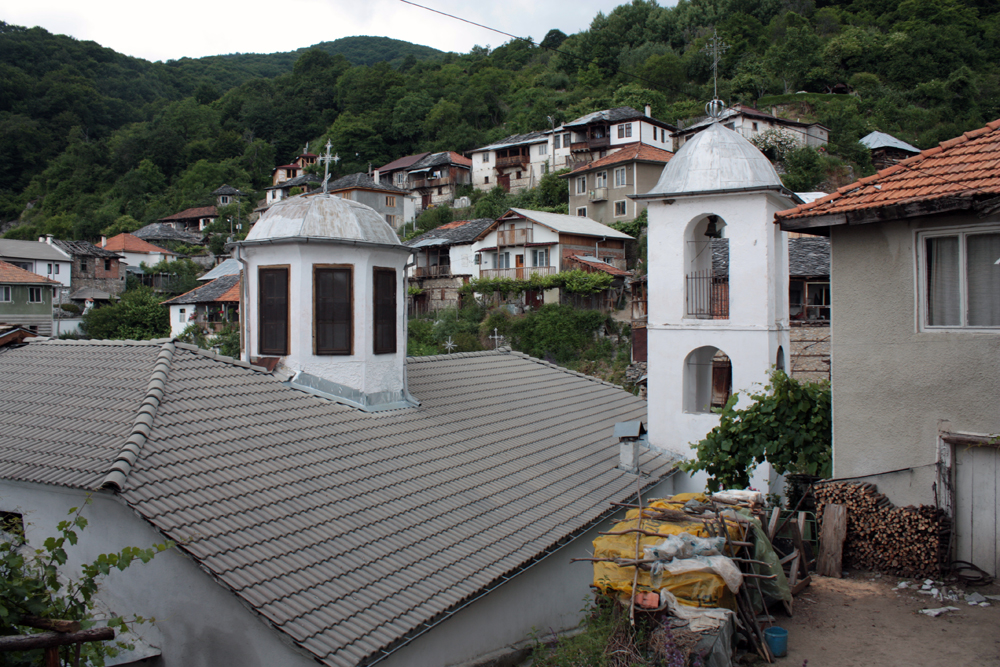
Delchevo (before 1934:''Yuch duruk'') is a village in Gotse Delchev Municipality, in Blagoevgrad Province, Bulgaria. The village is 3 kilometers southwest of Gotse Delchev and about 600 m higher in the Pirin mountain, 71 kilometers southeast of Blagoevgrad and is connected with the town of Gotse Delchev by a steep 8 kilometers long mountainous road, accessible during the whole year. There are a few permanent residents in the village. The only source of income is the touristic business. There aren't any industrial subjects in the village. The village has no school or community center. Remains of the Roman period have been unearthed and they are evidences of the long history of the settlement. The contemporary village has been found in the 17th century. In 1838, the Assumption church was built. In 1873, 69 households were counted with 250 Bulgarian people. Tobacco growing and livestock farming were the major sources of income. There were also some trading and crafts because of t ... [...More Info...] [...Related Items...] OR: [Wikipedia] [Google] [Baidu] |
Countries Of The World
The following is a list providing an overview of sovereign states around the world with information on their status and recognition of their sovereignty. The 206 listed states can be divided into three categories based on membership within the United Nations System: 193 member states of the United Nations, UN member states, 2 United Nations General Assembly observers#Present non-member observers, UN General Assembly non-member observer states, and 11 other states. The ''sovereignty dispute'' column indicates states having undisputed sovereignty (188 states, of which there are 187 UN member states and 1 UN General Assembly non-member observer state), states having disputed sovereignty (16 states, of which there are 6 UN member states, 1 UN General Assembly non-member observer state, and 9 de facto states), and states having a political status of the Cook Islands and Niue, special political status (2 states, both in associated state, free association with New Zealand). Compi ... [...More Info...] [...Related Items...] OR: [Wikipedia] [Google] [Baidu] |
Pirin
, photo=Pirin-mountains-Bansko.jpg , photo_caption=Pirin scenery in winter , country= Bulgaria, , parent= , geology= granite, gneiss, marble, limestone , area_km2=2585 , range_coordinates = , length_km=80 , length_orientation= north-south , width_km=40 , width_orientation= north-south , highest= Vihren , elevation_m=2915 , coordinates = , map_image=Bulgaria Pirin mountain geographic map bg.svg The Pirin Mountains ( bg, Пирин ) are a mountain range in southwestern Bulgaria, with Vihren at an altitude of 2,914 m being the highest peak. The range extends about 80 km from the north-west to the south-east and is about 40 km wide, spanning a territory of . To the north Pirin is separated from Bulgaria's highest mountain range, the Rila Mountain, by the Predel saddle, while to the south it reaches the Slavyanka Mountain. To the west is located the valley of the river Struma and to the east the valley of the river Mesta separates it from the Rh ... [...More Info...] [...Related Items...] OR: [Wikipedia] [Google] [Baidu] |
Mesta River
Nestos ( ), Mesta ( ), or formerly the Mesta Karasu in Turkish (Karasu meaning "black river"), is a river in Bulgaria and Greece. It rises in the Rila Mountains and flows into the Aegean Sea near the island of Thasos. It plunges down towering canyons toward the Aegean Sea through mostly metamorphic formations. At the end, the main stream spreads over the coastal plain of Chrysoupolis and expands as a deltaic system with freshwater lakes and ponds forming the Nestos delta. The length of the river is , of which flow through BulgariaStatistical Yearbook 2017 , p. 17 and the rest in [...More Info...] [...Related Items...] OR: [Wikipedia] [Google] [Baidu] |
Rhodope Mountains
The Rhodopes (; bg, Родопи, ; el, Ροδόπη, ''Rodopi''; tr, Rodoplar) are a mountain range in Southeastern Europe, and the largest by area in Bulgaria, with over 83% of its area in the southern part of the country and the remainder in Greece. Golyam Perelik is its highest peak at . The mountain range gives its name to the terrestrial ecoregion Rodope montane mixed forests that belongs in the temperate broadleaf and mixed forests biome and the Palearctic realm. The region is particularly notable for its karst areas with their deep river gorges, large caves and specific sculptured forms, such as the Trigrad Gorge. A significant part of Bulgaria's hydropower resources are located in the western areas of the range. There are a number of hydro-cascades and dams used for electricity production, irrigation, and as tourist destinations. In Greece, there are also the hydroelectric power plants of Thisavros and Platanovrysi. The Rhodopes have a rich cultural heritage including a ... [...More Info...] [...Related Items...] OR: [Wikipedia] [Google] [Baidu] |
Ilinden–Preobrazhenie Uprising
The Ilinden–Preobrazhenie Uprising, or simply the Ilinden Uprising of August–October 1903 ( bg, Илинденско-Преображенско въстание, Ilindensko-Preobrazhensko vastanie; mk, Илинденско востание, Ilindensko vostanie; el, Εξέγερση του Ίλιντεν, Eksegersi tou Ilinden), was an organized revolt against the Ottoman Empire, which was prepared and carried out by the Internal Macedonian-Adrianople Revolutionary Organization, with the support of the Supreme Macedonian-Adrianople Committee. The name of the uprising refers to ''Ilinden'', a name for Elijah's day, and to ''Preobrazhenie'' which means Transfiguration. Some historians describe the rebellion in the Serres revolutionary district as a separate uprising, calling it the Krastovden Uprising (Holy Cross Day Uprising), because on September 14 the revolutionaries there also rebelled. The revolt lasted from the beginning of August to the end of October and covered a va ... [...More Info...] [...Related Items...] OR: [Wikipedia] [Google] [Baidu] |
Blagoevgrad
Blagoevgrad ( bg, Благоевград ) is а town in Southwestern Bulgaria, the administrative centre of Blagoevgrad Municipality and of Blagoevgrad Province. With a population of almost inhabitants, it is the economic and cultural centre of Southwestern Bulgaria. It is located in the valley of the Struma River at the foot of the Rila Mountains, south of Sofia, close to the border with North Macedonia. Blagoevgrad features a pedestrian downtown, with preserved 19th-century architecture and numerous restaurants, cafés, coffee shops, and boutiques. It is home to two universities, the South-West University "Neofit Rilski" and the American University in Bulgaria. The town also hosts the "Sts. Cyril and Methodius National Humanitarian High School". The former Bulgarian Men's High School of Thessaloniki moved from Thessaloniki to Blagoevgrad (then Gorna Dzhumaya) in 1913. Name In Ottoman times the town was known as ''Yukarı Cuma'' in Turkish or ''Gorna Dzhumaya'' in Bulgar ... [...More Info...] [...Related Items...] OR: [Wikipedia] [Google] [Baidu] |
Gotse Delchev (town)
Gotse Delchev ( bg, Гоце Делчев ), is a town in Gotse Delchev Municipality in Blagoevgrad Province of Bulgaria. In 1951, the town was renamed after the Bulgarian revolutionary hero Gotse Delchev. It had hitherto been called Nevrokop (in bg, Неврокоп, ; in el, Άνω Νευροκόπι, ''Ano'' ; and in tr, Nevrokop). Nearby are the remains of a walled city established by the Romans in the 2nd century AD. The town was a kaza in the Siroz sanjak of the Salonica vilayet before the Balkan Wars. Geography Gotse Delchev is situated in a mountainous area, about from the capital Sofia and from the city of Blagoevgrad in the southern part of Blagoevgrad district. The town center is above sea level. The Gotse Delchev Hollow is characterized by a continental climate; rainfall occurs mainly during spring and autumn, and summers are hot and dry. Winter temperature inversions are possible. Population History Antiquity and Medieval period Nicopolis ad Nestum ... [...More Info...] [...Related Items...] OR: [Wikipedia] [Google] [Baidu] |
Provinces Of Bulgaria
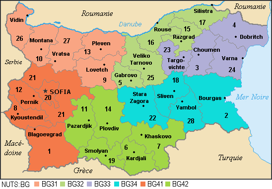
The provinces of Bulgaria ( bg, области на България, oblasti na Bǎlgarija) are the first-level administrative subdivisions of the country. Since 1999, Bulgaria has been divided into 28 provinces ( bg, области, links=no – ''oblasti;'' singular: – ''oblast''; also translated as "regions") which correspond approximately to the 28 districts (in bg, links=no, окръг – ''okrug, okrǎg'', plural: – ''okrǎzi''), that existed before 1987. The provinces are further subdivided into 265 municipalities (singular: – ''obshtina'', plural: – ''obshtini''). Sofia – the capital city of Bulgaria and the largest settlement in the country – is the administrative centre of both Sofia Province and Sofia City Province (Sofia-Grad (toponymy), grad). The capital is included (together with three other cities plus 34 villages) in Sofia Capital Municipality (over 90% of whose population lives in Sofia), which is the sole municipality comprising Sofia City ... [...More Info...] [...Related Items...] OR: [Wikipedia] [Google] [Baidu] |
Bulgaria
Bulgaria (; bg, България, Bǎlgariya), officially the Republic of Bulgaria,, ) is a country in Southeast Europe. It is situated on the eastern flank of the Balkans, and is bordered by Romania to the north, Serbia and North Macedonia to the west, Greece and Turkey to the south, and the Black Sea to the east. Bulgaria covers a territory of , and is the sixteenth-largest country in Europe. Sofia is the nation's capital and largest city; other major cities are Plovdiv, Varna and Burgas. One of the earliest societies in the lands of modern-day Bulgaria was the Neolithic Karanovo culture, which dates back to 6,500 BC. In the 6th to 3rd century BC the region was a battleground for ancient Thracians, Persians, Celts and Macedonians; stability came when the Roman Empire conquered the region in AD 45. After the Roman state splintered, tribal invasions in the region resumed. Around the 6th century, these territories were settled by the early Slavs. The Bulgars, led by Asp ... [...More Info...] [...Related Items...] OR: [Wikipedia] [Google] [Baidu] |
Eastern European Summer Time
Eastern European Summer Time (EEST) is one of the names of the UTC+03:00 time zone, which is 3 hours ahead of Coordinated Universal Time. It is used as a summer daylight saving time in some European and Middle Eastern countries, which makes it the same as Arabia Standard Time, East Africa Time, and Moscow Time. During the winter periods, Eastern European Time ( UTC+02:00) is used. Since 1996, European Summer Time has been applied from the last Sunday in March to the last Sunday in October. Previously, the rules were not uniform across the European Union. Usage The following countries and territories use Eastern European Summer Time during the summer: * Belarus, Moscow Summer Time in years 1981–89, regular EEST from 1991-2011 * Bulgaria, regular EEST since 1979 * Cyprus, regular EEST since 1979 ( Northern Cyprus stopped using EEST in September 2016, but returned to EEST in March 2018) * Estonia, Moscow Summer Time in years 1981–88, regular EEST since 1989 * Finland, regu ... [...More Info...] [...Related Items...] OR: [Wikipedia] [Google] [Baidu] |


