|
Degol Woyane
Degol Woyane is a ''tabia'' or municipality in the Dogu'a Tembien district of the Tigray Region of Ethiopia. It includes Dabba Selama, the oldest monastery of Ethiopia, and the most inaccessible in the world. The ''tabia'' centre is in Zala village, located approximately 10 km to the west of the ''woreda'' town Hagere Selam. Geography The ''tabia'' stretches down west of Melfa, along the westernmost ridge of Dogu'a Tembien. The highest peak is T'afa (2580 m a.s.l.) and the lowest place Addi Welo (1990 m a.s.l.). Geology From the higher to the lower locations, the following geological formations are present: * Lower basalt * Amba Aradam Formation * Adigrat Sandstone Springs As there are no permanent rivers, the presence of springs is of utmost importance for the local people. The following are the springs in the tabia: * May Dara in Zala * Addi Welo Livelihood The population lives essentially from crop farming, supplemented with off-season work in nearby towns. T ... [...More Info...] [...Related Items...] OR: [Wikipedia] [Google] [Baidu] |
Mesa
A mesa is an isolated, flat-topped elevation, ridge or hill, which is bounded from all sides by steep escarpments and stands distinctly above a surrounding plain. Mesas characteristically consist of flat-lying soft sedimentary rocks capped by a more resistant layer or layers of harder rock, e.g. shales overlain by sandstones. The resistant layer acts as a caprock that forms the flat summit of a mesa. The caprock can consist of either sedimentary rocks such as sandstone and limestone; dissected lava flows; or a deeply eroded duricrust. Unlike ''plateau'', whose usage does not imply horizontal layers of bedrock, e.g. Tibetan Plateau, the term ''mesa'' applies exclusively to the landforms built of flat-lying strata. Instead, flat-topped plateaus are specifically known as '' tablelands''.Duszyński, F., Migoń, P. and Strzelecki, M.C., 2019. ''Escarpment retreat in sedimentary tablelands and cuesta landscapes–Landforms, mechanisms and patterns.'' ''Earth-Science Reviews, no. ... [...More Info...] [...Related Items...] OR: [Wikipedia] [Google] [Baidu] |
Geomorphology
Geomorphology (from Ancient Greek: , ', "earth"; , ', "form"; and , ', "study") is the scientific study of the origin and evolution of topographic and bathymetric features created by physical, chemical or biological processes operating at or near Earth's surface. Geomorphologists seek to understand why landscapes look the way they do, to understand landform and terrain history and dynamics and to predict changes through a combination of field observations, physical experiments and numerical modeling. Geomorphologists work within disciplines such as physical geography, geology, geodesy, engineering geology, archaeology, climatology, and geotechnical engineering. This broad base of interests contributes to many research styles and interests within the field. Overview Earth's surface is modified by a combination of surface processes that shape landscapes, and geologic processes that cause tectonic uplift and subsidence, and shape the coastal geography. Surface processes co ... [...More Info...] [...Related Items...] OR: [Wikipedia] [Google] [Baidu] |
Aregen
Aregen is a ''tabia'' or municipality in the Dogu'a Tembien district of the Tigray Region of Ethiopia. The ''tabia'' centre is in Addi Gotet village, located approximately to the west-southwest of the ''woreda'' town Hagere Selam. Geography The ''tabia'' occupies an elongated ridge between the gorges of Upper Tanqwa and Tsech'i Rivers. The highest peak is near Aregen village ( a.s.l.) and the lowest place at the confluence of the two rivers ( a.s.l.). Geology From the higher to the lower locations, the following geological formations are present: * Lower basalt * Amba Aradam Formation * Antalo Limestone * Adigrat Sandstone Geomorphology and soils The main geomorphic units, with corresponding soil types are: * Hagere Selam Highlands, along the central basalt and sandstone ridge ** Associated soil types *** shallow soils with high stone contents (Skeletic Cambisol, Leptic Cambisol, Skeletic Regosol) *** moderately deep dark stony clays with good natural fertility (Ver ... [...More Info...] [...Related Items...] OR: [Wikipedia] [Google] [Baidu] |
Melfa (Dogu'a Tembien)
Dogu'a Tembien Melfa is a ''tabiya'' or municipality in the Dogu'a Tembien district of the Tigray Region of Ethiopia and ancient capital of Tembien. The ''tabia'' centre is Melfa village itself, located approximately 3 km to the west of the ''woreda'' town Hagere Selam. Geography The ''tabia'' stretches down from the ridge at 2700 m a.s.l. towards Zelekwa/Ruba Dirho River (2150 m a.s.l.). Geology From the higher to the lower locations, the following geological formations are present: * Upper basalt * Interbedded lacustrine deposits * Lower basalt * Amba Aradam Formation * Antalo Limestone Geomorphology and soils The main geomorphic unit is the Hagere Selam Highlands. Corresponding soil types are: * Associated soil types ** shallow soils with high stone contents (Skeletic Cambisol, Leptic Cambisol, Skeletic Regosol) ** moderately deep dark stony clays with good natural fertility (Vertic Cambisol) ** deep, dark cracking clays, temporarily waterlogged during th ... [...More Info...] [...Related Items...] OR: [Wikipedia] [Google] [Baidu] |
Mahbere Sillasie
Mahbere Sillasie is a ''tabia'' or municipality in the Dogu'a Tembien district of the Tigray Region of Ethiopia. The ''tabia'' centre is in Guderbo village, located approximately 2.5 km to the west-northwest of the ''woreda'' town Hagere Selam. Geography The ''tabia'' stretches down from the ridge west of Hagere Selam, northbound towards Tsaliet river. The highest peak is just south of Guderbo (2730 m a.s.l.) and the lowest place deep in the Tsaliet gorge (1780 m a.s.l.). Geology From the higher to the lower locations, the following geological formations are present: * Phonolite plugs * Upper basalt * Interbedded lacustrine deposits * Lower basalt * Amba Aradam Formation * Antalo Limestone * Adigrat Sandstone Climate The rainfall pattern shows a very high seasonality with 70 to 80% of the annual rain falling in July and August. Mean temperature in Guderbo is 17.4 °C, oscillating between average daily minimum of 9.6 °C and maximum of 24.8 ... [...More Info...] [...Related Items...] OR: [Wikipedia] [Google] [Baidu] |
Mekelle
Mekelle ( ti, መቐለ, am, መቀሌ, mäqälle, mek’elē) or Mekele is a List of zones of Ethiopia, special zone and capital city, capital of the Tigray Region of Ethiopia. Mekelle was formerly the capital of Enderta province, Enderta Awrajja, awraja in Tigray Province, Tigray. It is located around north of the Ethiopian capital Addis Ababa, with an elevation of above sea level. Administratively, Mekelle is considered a Special Zone, which is divided into seven sub-cities. It is the economic, cultural, and political hub of northern Ethiopia. Mekelle has grown rapidly since 1991 with a population of 61,000 in 1984, 97,000 inhabitants in 1994 (96.5% being Tigrinya-speakers), and 170,000 in 2006 (i.e. 4% of the population of Tigray). Mekelle is the second-largest city in Ethiopia after Addis Ababa, with a population of around 545,000. It is 2.6 times larger than Adigrat, the second-largest regional center. The majority of the population of Mekelle depends on government employm ... [...More Info...] [...Related Items...] OR: [Wikipedia] [Google] [Baidu] |
Abiy Addi
Abiy Addi (also spelled Abi Addi; Tigrigna ዓብዪ ዓዲ "Big town") is a town in central Tigray Region, Tigray, Ethiopia. Abiy Addi is at the southeastern edge of the Kola Tembien woreda, of which it is the capital. Overview The town is divided into two parts by the Tanqwa, Tanqwa River, the lower part being the more respectable part while the upper part "is where you'll find the marketplace ... and the seedier bars in which you're most likely to see Awri dancing as the ''tej'' hits the mark." Briggs notes that Abiy Addi is known in Tigray for the frenetic style of dancing called "Awri", as well as the quality of its honey. Having visited Abiy Abbi in the mid-1940s, David Roden Buxton, David Buxton thought that "perhaps the best thing about Abbi Addi was the panorama of the Semien Mountains, Simien mountains standing to the west beyond the deep valley of the Tekezé." Buxton notes that the entire height of that mountain range was visible, from the southern foothills to the ... [...More Info...] [...Related Items...] OR: [Wikipedia] [Google] [Baidu] |
Siwa (beer)
Siwa (or Suwa) ( ti, ሰዋ, translit=säwa), Amharic: ጠላ, is a beer originating from Tigray. Traditionally home-brewed, ''siwa'' remains locally popular during social events, after (manual) work, and as an incentive for farmers and labourers. Thousands of traditional beer houses (''Inda Siwa'') straddle the Tigrayan urban and rural landscapes. ''Siwa'', the traditional beer of Tigray In almost every rural household of Tigray, the woman knows how to prepare the local beer, ''siwa'' in Tigrinya language. Basic ingredients are water, a home-baked and toasted flat bread commonly made from barley in the highlands, and from sorghum, finger millet or maize in the lowlands, some yeast (''Saccharomyces cerevisiae''), and dried leaves of ''gesho'' (''Rhamnus prinoides'') that serve as a catalyser. The brew is allowed to ferment for a few days, after which it is served, sometimes with the pieces of bread floating on it (the customer will gently blow them to one side of the beaker). T ... [...More Info...] [...Related Items...] OR: [Wikipedia] [Google] [Baidu] |
Kola Tembien
Kola Tembien (, "Lower Tembien") is a woreda in Tigray Region, Ethiopia. It is named in part after the former province of Tembien. Part of the Mehakelegnaw Zone, Kola Tembien is bordered on the south by Abergele, on the west by the Tekezé River which separates it from the Semien Mi'irabawi (North Western) Zone, on the north by the Wari River which separates it from Naeder Adet and Werie Lehe, on the east by Misraqawi (Eastern) Zone, and on the southeast by Degua Tembien. Towns in Kola Tembien include Guya and Werkamba. The town of Abiy Addi is surrounded by Kola Tembien. Demographics Based on the 2007 national census conducted by the Central Statistical Agency of Ethiopia (CSA), this woreda has a total population of 134,336, an increase of 28.13% over the 1994 census, of whom 66,925 are men and 67,411 women; 0 or 0.00% are urban inhabitants. With an area of 2,538.39 square kilometers, Kola Tembien has a population density of 52.92, which is 56.29 than the Zone average ... [...More Info...] [...Related Items...] OR: [Wikipedia] [Google] [Baidu] |
Birdwatching
Birdwatching, or birding, is the observing of birds, either as a recreational activity or as a form of citizen science. A birdwatcher may observe by using their naked eye, by using a visual enhancement device like binoculars or a telescope, by listening for bird sounds, or by watching public webcams. Most birdwatchers pursue this activity for recreational or social reasons, unlike ornithologists, who engage in the study of birds using formal scientific methods. Birding, birdwatching, and twitching The first recorded use of the term ''birdwatcher'' was in 1901 by Edmund Selous; ''bird'' was introduced as a verb in 1918. The term ''birding'' was also used for the practice of ''fowling'' or hunting with firearms as in Shakespeare's '' The Merry Wives of Windsor'' (1602): "She laments sir... her husband goes this morning a-birding." The terms ''birding'' and ''birdwatching'' are today used by some interchangeably, although some participants prefer ''birding'', partly because it ... [...More Info...] [...Related Items...] OR: [Wikipedia] [Google] [Baidu] |
Tsaliet
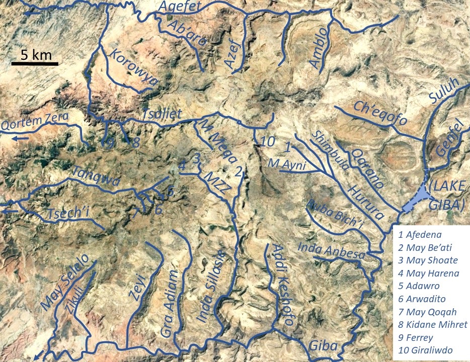
Tsaliet is a river in northern Ethiopia, belonging to the Nile basin. Rising in the mountains of Dogu’a Tembien, where it is first called May Leiba River and then Tinsehe River, it flows westward through a deep gorge, to become Tsaliet in its lower course, where it empties in Weri’i River, just upstream of the main Weri’i bridge along the road to Adwa. Characteristics It is mostly a confined river, locally meandering in its narrow alluvial plain, with an average slope gradient of 25 metres per kilometre. With its tributaries, the river has cut deep gorges. Along the middle of its course, it occupies sandy pediments in Addeha. Flash floods and flood buffering Runoff mostly happens in the form of high runoff discharge events that occur in a very short period (called flash floods). These are related to the steep topography, often little vegetation cover and intense convective rainfall. The peaks of such flash floods have often a 50 to 100 times larger discharge than the ... [...More Info...] [...Related Items...] OR: [Wikipedia] [Google] [Baidu] |
Atse Yohannes School (Zala)
The emperor of Ethiopia ( gez, ንጉሠ ነገሥት, nəgusä nägäst, "King of Kings"), also known as the Atse ( am, ዐፄ, "emperor"), was the hereditary ruler of the Ethiopian Empire, from at least the 13th century until the abolition of the monarchy in 1975. The emperor was the head of state and head of government, with ultimate executive, judicial and legislative power in that country. A ''National Geographic'' article from 1965 called imperial Ethiopia "nominally a constitutional monarchy; in fact t wasa benevolent autocracy". Title and style The title "King of Kings", often rendered imprecisely in English as "emperor", dates back to ancient Mesopotamia, but was used in Axum by King Sembrouthes (c. 250 AD). However, Yuri Kobishchanov dates this usage to the period following the Persian victory over the Romans in 296–297. The most notable pre-Solomonic usage of the title "Negusa Nagast" was by Ezana of Axum; despite this, prior to the beginning of the Solomonic Dy ... [...More Info...] [...Related Items...] OR: [Wikipedia] [Google] [Baidu] |


