|
Darkut Pass
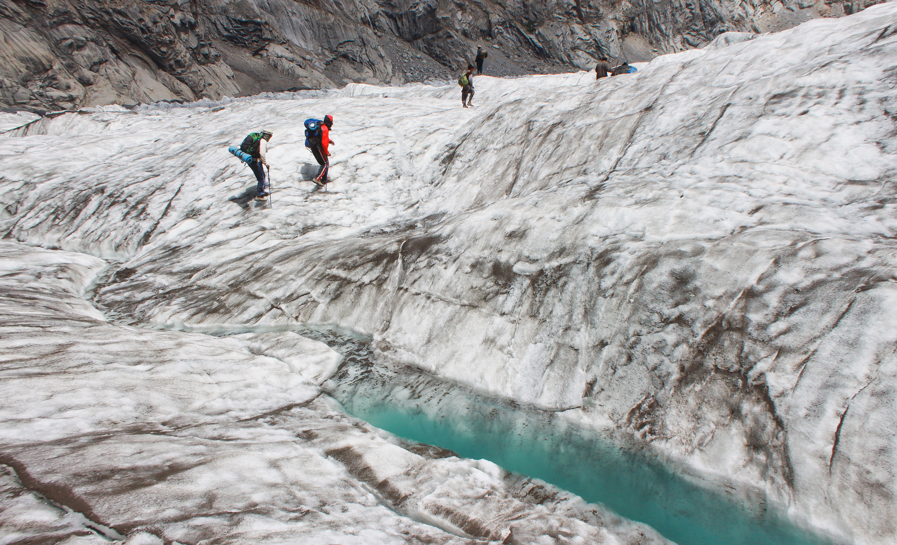
Darkot pass ( ur, {{nq, درۂ درکوٹ ) (el. 15,430 ft., open May through October) is a high mountain pass that connects Baroghil Valley in Chitral and Rawat valley of Ghizer District in Gilgit, Pakistan Pakistan ( ur, ), officially the Islamic Republic of Pakistan ( ur, , label=none), is a country in South Asia. It is the world's fifth-most populous country, with a population of almost 243 million people, and has the world's second-lar .... It is also known as "Darkut". The pass is about 10 miles to the east of Koyo Zom (Zum) (6872m), the highest peak in Ghizer District. The border between Chitral and Northern Areas runs through the pass over Darkot Glacier. Eight miles to the south is Darkot village on the River Darkot, a small tributary of Ghizer River). To the southwest of Darkot pass is Chitral. Ten miles to the northwest of the pass is Chilmarabad, a village one mile south of the Boroghil pass. See also * Chikaar * Baroghil Valley Mountain ... [...More Info...] [...Related Items...] OR: [Wikipedia] [Google] [Baidu] |
Gilgit-Baltistan
Gilgit-Baltistan (; ), formerly known as the Northern Areas, is a region administered by Pakistan as an administrative territory, and constituting the northern portion of the larger Kashmir region which has been the subject of a dispute between India and Pakistan since 1947, and between India and China from somewhat later.The application of the term "administered" to the various regions of Kashmir and a mention of the Kashmir dispute is supported by the tertiary sources (a) through (d), reflecting due weight in the coverage. Although "controlled" and "held" are also applied neutrally to the names of the disputants or to the regions administered by them, as evidenced in sources (e) through (g) below, "held" is also considered politicized usage, as is the term "occupied," (see (h) below): (a) (subscription required) Quote: "Kashmir, region of the northwestern Indian subcontinent ... has been the subject of dispute between India and Pakistan since the partition of the Indian ... [...More Info...] [...Related Items...] OR: [Wikipedia] [Google] [Baidu] |
Khyber Paktunkhwa
Khyber Pakhtunkhwa (; ps, خېبر پښتونخوا; Urdu, Hindko: خیبر پختونخوا) commonly abbreviated as KP or KPK, is one of the four provinces of Pakistan. Located in the northwestern region of the country, Khyber Pakhtunkhwa is the smallest province of Pakistan by land area and the third-largest province by population after Punjab and Sindh. It shares land borders with the Pakistani provinces of Balochistan to the south, Punjab to the south-east and province of Gilgit-Baltistan to the north and north-east, as well as Islamabad Capital Territory to the east, Autonomous Territory of Azad Jammu and Kashmir to the north-east. It shares an international border with Afghanistan to the west. Khyber Pakhtunkhwa is known as a tourist hot spot for adventurers and explorers and has a varied landscape ranging from rugged mountain ranges, valleys, plains surrounded by hills, undulating submontane areas and dense agricultural farms. While it is the third-largest Pakista ... [...More Info...] [...Related Items...] OR: [Wikipedia] [Google] [Baidu] |
Hindukush Mountains
The Hindu Kush is an mountain range in Central and South Asia to the west of the Himalayas. It stretches from central and western Afghanistan, Quote: "The Hindu Kush mountains run along the Afghan border with the North-West Frontier Province of Pakistan". into northwestern Pakistan and far southeastern Tajikistan. The range forms the western section of the ''Hindu Kush Himalayan Region'' (''HKH''); to the north, near its northeastern end, the Hindu Kush buttresses the Pamir Mountains near the point where the borders of China, Pakistan and Afghanistan meet, after which it runs southwest through Pakistan and into Afghanistan near their border. The eastern end of the Hindu Kush in the north merges with the Karakoram Range.Karakoram Range: MOUNTAINS, ASIA Encyclopædia Britannica Towards its sou ... [...More Info...] [...Related Items...] OR: [Wikipedia] [Google] [Baidu] |
Mountain Pass
A mountain pass is a navigable route through a mountain range or over a ridge. Since many of the world's mountain ranges have presented formidable barriers to travel, passes have played a key role in trade, war, and both Human migration, human and animal migration throughout history. At lower elevations it may be called a hill pass. A mountain pass is typically formed between two volcanic peaks or created by erosion from water or wind. Overview Mountain passes make use of a gap (landform), gap, saddle (landform), saddle, col or notch (landform), notch. A topographic saddle is analogous to the mathematical concept of a saddle surface, with a saddle point marking the highest point between two valleys and the lowest point along a ridge. On a topographic map, passes are characterized by contour lines with an hourglass shape, which indicates a low spot between two higher points. In the high mountains, a difference of between the summit and the mountain is defined as a mountain pas ... [...More Info...] [...Related Items...] OR: [Wikipedia] [Google] [Baidu] |
Baroghil Valley
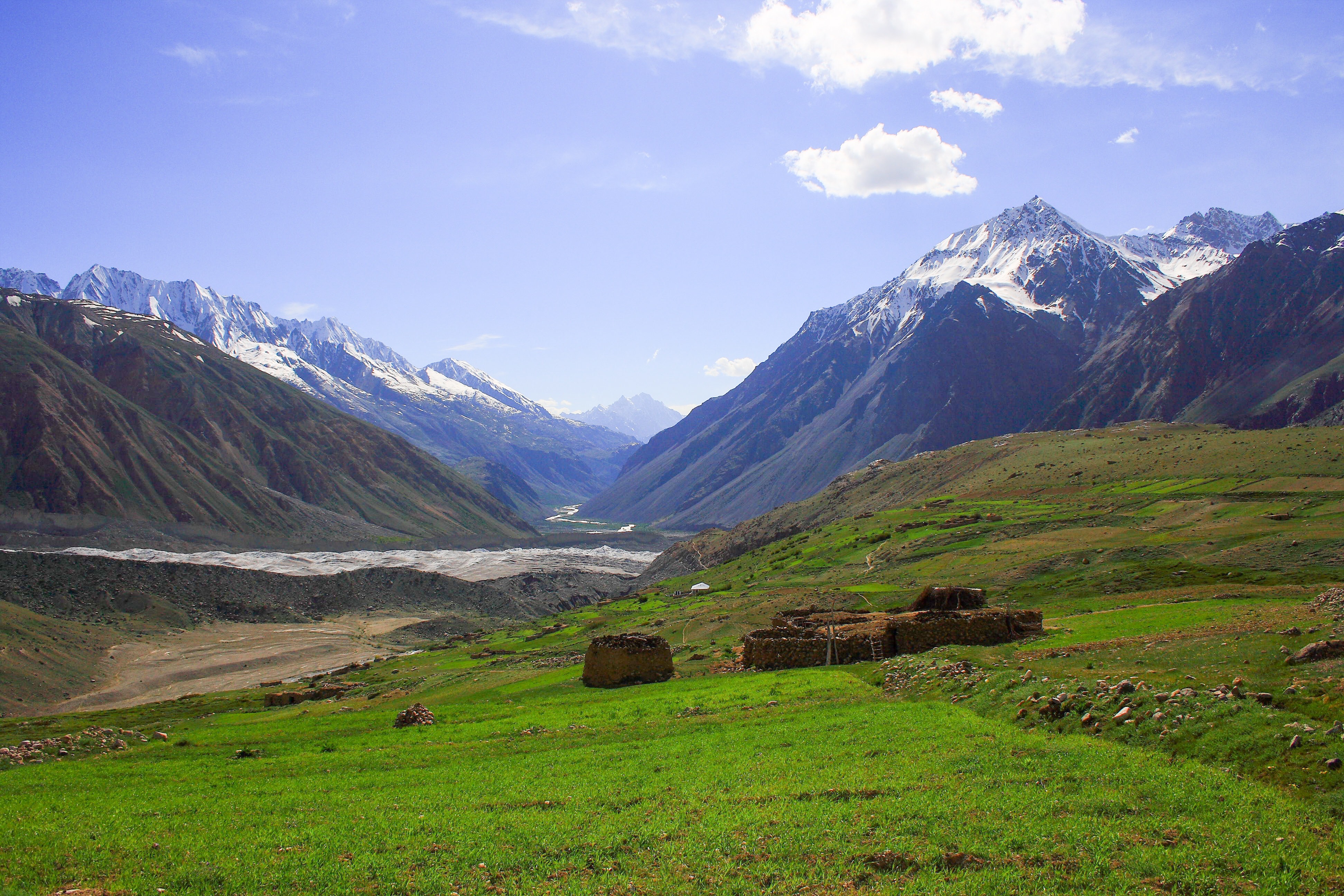
Broghil Valley National Park ( ur, بروغل) is located in the upper northern reaches of the Chitral District, Khyber Pakhtunkhwa, Pakistan, close to the Afghan-Pakistan border. Geography Broghil Valley is from the main town of Chitral and is the northernmost valley within the Chitral district. Broghil valley borders on the Afghan Wakhan corridor, which stretches between Tajikistan and Pakistan. The area is mostly mountainous. Elevations range from between at the village of Kishmanjah to at Karambar Lake in the northeast. The terrain is undulating with mountains, grassy plains, and valleys. It includes almost 3,400 ha of peatlands and lakes.Hydrological assessment of significant lakes in Broghil and Qurumbar Valleys, Northern Alpine Wetlands Complex. The valley features around 30 freshwater lakes and is surrounded by glaciers and mountains. Tourism The Broghil valley’s remote location makes it a hard-to-reach tourist destination. Many communities in Broghil lack ac ... [...More Info...] [...Related Items...] OR: [Wikipedia] [Google] [Baidu] |
Chitral
Chitral ( khw, , lit=field, translit=ćhitrār; ur, , translit=ćitrāl) is situated on the Chitral River in northern Khyber Pakhtunkhwa, Pakistan. It serves as the capital of the Chitral District and before that as the capital of Chitral princely state that encompassed the region until its direct incorporation into West Pakistan on 14 August 1947. It has a population of 49,780 per the 2017 census. History Gankoreneotek Grave This city was founded as the name of Qāshqār in ancient timesIt was famous Gandharan trade route at this time.Gankorineotek cemetery is also existed here. Early history The Kho Chitralis came to Chitral as part of the Indo-Aryan migration into South Asia. They settled in the northern parts of Chitral near the Torkhow and Mulkhow Region. Ancient era The existence of the Gandharan Grave Culture in Chitral, found in various grave sites scattered over its valleys, indicate its proximity towards the Gandharan culture alongside giving insigh ... [...More Info...] [...Related Items...] OR: [Wikipedia] [Google] [Baidu] |
Gupis-Yasin District
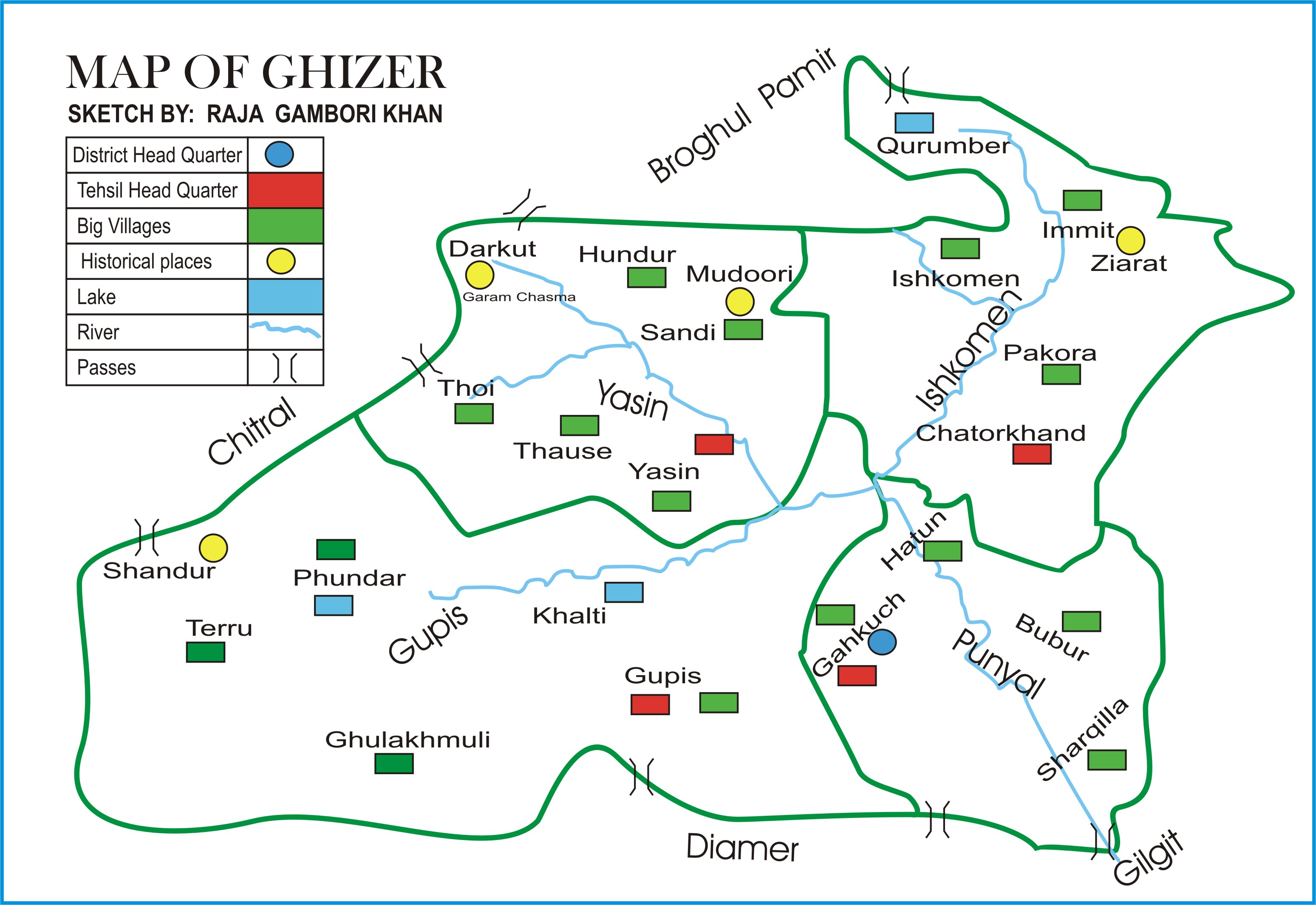
The Gupis-Yasin District ( ur, ) is the westernmost district of the 14 districts of Pakistan-administered territory of Gilgit-Baltistan. The Gupis-Yasin District was created in 2019 from the Gupis Tehsil and the Yasin Tehsil, which were the two western tehsils of the former, larger Ghizer District. Geography The Gupis-Yasin District is bounded on the north and west by the Upper Chitral District of Pakistan's Khyber Pakhtunkhwa Province, on the east by the Ghizer District, on the south by the Swat District of Pakistan's Khyber Pakhtunkhwa Province and the Upper Kohistan District of Pakistan's Khyber Pakhtunkhwa Province. The map of the former Ghizer District shows the Yasin Tehsil and the former, larger Gupis Tehsil, which was subsequently divided into two tehsils: the present, smaller Gupis Tehsil and the Phander Tehsil. The present Ghizer District consists of the Ishkoman Tehsil and the Punial Tehsil. Administration The Gupis-Yasin District consists of three tehsils: ... [...More Info...] [...Related Items...] OR: [Wikipedia] [Google] [Baidu] |
Gilgit Valley
Gilgit Valley () is a valley located in Gilgit District in Gilgit-Baltistan, northern Pakistan. The Gilgit River flows through the valley. 375 km of road connects it to the town of Chitral via the Shandur Pass Shandur Pass( ur, ) is a pass located in Ghizer, District of Gilgit Baltistan . It is often called 'Roof of the World. During the annual ' Shandur Polo Festival,' there are polo matches played in Shandur Polo Ground on Shandur Top, between the ... (3,800 m). The town of Gilgit lies in the valley. File:Gilgit Valley, 2006.jpg, Gilgit Valley Image:Gilgit Valley 3.JPG, Gilgit Valley Image:Gilgit Valley from Sonikot 3.Jpg, Gilgit Valley from Sonikot Image:Gilgit Valley 2.Jpg, Broad View Of Gilgit Valley References Valleys of Gilgit-Baltistan {{G-B-geo-stub ur:گلگت ... [...More Info...] [...Related Items...] OR: [Wikipedia] [Google] [Baidu] |
Pakistan
Pakistan ( ur, ), officially the Islamic Republic of Pakistan ( ur, , label=none), is a country in South Asia. It is the world's List of countries and dependencies by population, fifth-most populous country, with a population of almost 243 million people, and has the world's Islam by country#Countries, second-largest Muslim population just behind Indonesia. Pakistan is the List of countries and dependencies by area, 33rd-largest country in the world by area and 2nd largest in South Asia, spanning . It has a coastline along the Arabian Sea and Gulf of Oman in the south, and is bordered by India to India–Pakistan border, the east, Afghanistan to Durand Line, the west, Iran to Iran–Pakistan border, the southwest, and China to China–Pakistan border, the northeast. It is separated narrowly from Tajikistan by Afghanistan's Wakhan Corridor in the north, and also shares a maritime border with Oman. Islamabad is the nation's capital, while Karachi is its largest city and fina ... [...More Info...] [...Related Items...] OR: [Wikipedia] [Google] [Baidu] |
Ghizer River
The Gilgit River () is a tributary of the Indus River, and flows through the Gupis-Yasin, Ghizer and Gilgit districts of Gilgit-Baltistan. The Gilgit River starts from Shandur Lake, and joins the Indus River at near towns of Juglot and Bunji, where also the three mountain ranges of Hindu Kush, Himalaya and Karakoram ranges are believed to meet. The upper sections of the Gilgit river are called Gupis River and Ghizer River. See also *Shandur Pass Shandur Pass( ur, ) is a pass located in Ghizer, District of Gilgit Baltistan . It is often called 'Roof of the World. During the annual ' Shandur Polo Festival,' there are polo matches played in Shandur Polo Ground on Shandur Top, between the ... References Tributaries of the Indus River Rivers of Gilgit-Baltistan Karakoram Rivers of Pakistan {{Pakistan-river-stub ... [...More Info...] [...Related Items...] OR: [Wikipedia] [Google] [Baidu] |
Boroghil
Broghil, also spelled Broghol, elevation , is a high mountain pass along the Durand Line border that crosses the Hindu Kush mountain range and connects Wakhan District of Badakhshan Province, Afghanistan with Chitral District of Khyber Pakhtunkhwa, Pakistan. History Broghil is a relatively low pass. It was closed for about three months each winter because of snow, but for much of the rest of the year it was passable even for cart traffic. It is one of the four major mountain passes entering Chitral District; the others are the Dorah Pass from Badakshan Province of Afghanistan, Shandur Top from Gilgit, and Lowari Top from Upper Dir District. The area of Broghil is inhabited by Wakhi and Kyrgyz people. European migration According to the National Geographic Genographic Project, Broghol Pass appears to be the route used by the ancestors of all modern Western Europeans to reach Europe. Modern Europeans carrying the M45 genetic marker crossed Broghol and then turne ... [...More Info...] [...Related Items...] OR: [Wikipedia] [Google] [Baidu] |
Chikaar
Chikaar ( ur, ) is a high plain and gateway to Darkot Pass The border between Chitral District and Gupis-Yasin District of Gilgit-Baltistan. It is a small village of around 200 families. Landscape around the village offers superb scenery of clouds and sky piercing peaks. In the last decade it has got significant importance due to the relatively easy route that it offers towards Darkot Pass. Climbers and trekkers take porters from this point towards Darkot base camp. Though electricity is not available but few of the houses have solar panels to run home appliances. Usually trekkers take the benefit out of their hospitality and get their electronic equipment i.e. phone, camera etc. charged through solar panels. An upper and next stage is Darkoot base-camp (often quoted as Chikaar Base). Chikaar base-camp is located at the left side of the accumulation zone of the Darkoot glacier. Trekkers and climbers make stopovers here to start their journey towards Darkot pass from Darkot gl ... [...More Info...] [...Related Items...] OR: [Wikipedia] [Google] [Baidu] |


