|
Dalny, Chukotka Autonomous Okrug
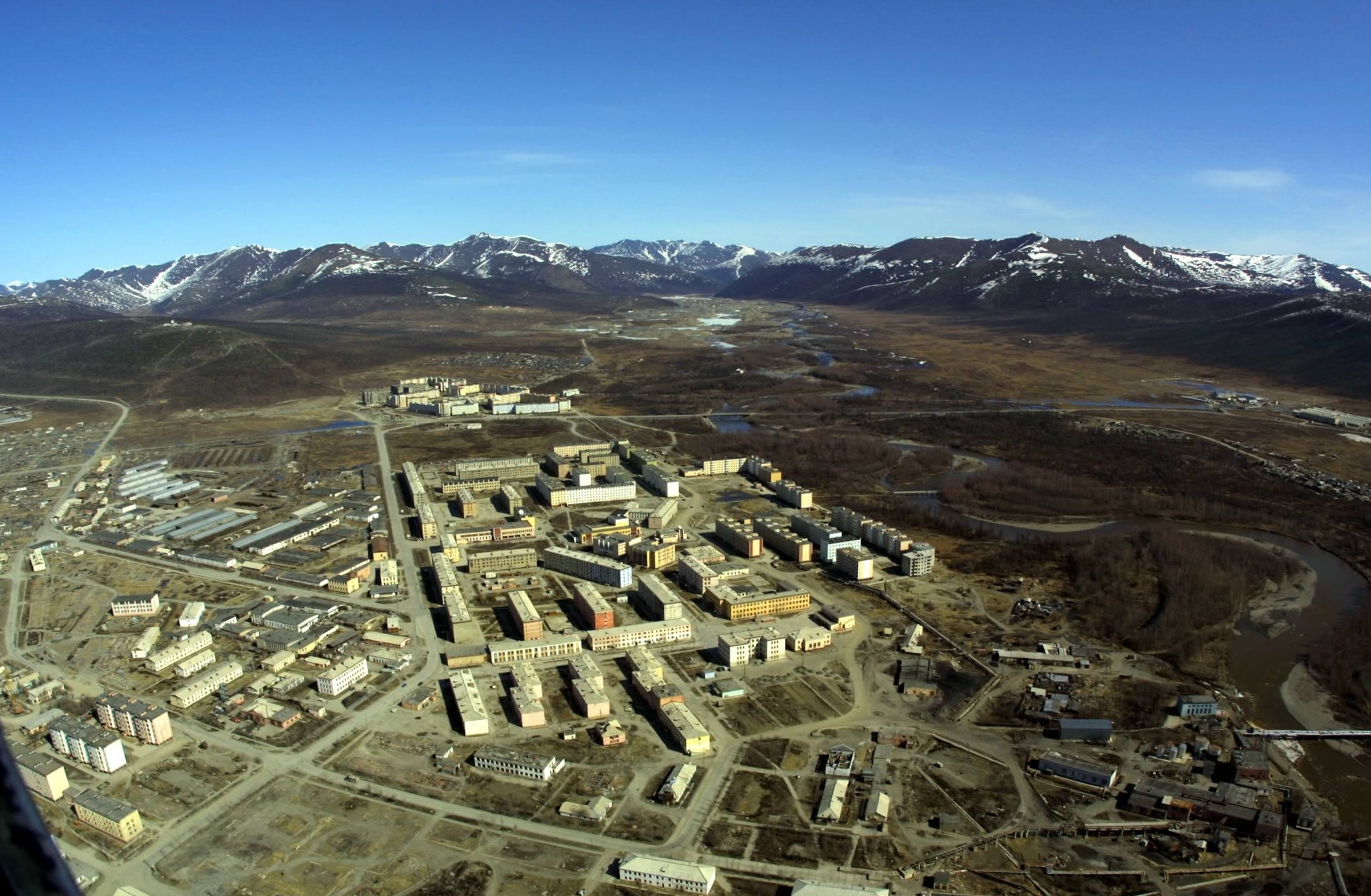
Dalny (russian: Да́льний , lit. ''remote'' or ''far'') is an urban locality (a work settlement) in Bilibinsky District of Chukotka Autonomous Okrug, Russia, located west of Bilibino. History The settlement was abandoned as a result of the extraction of gold no longer being economically viable. The mines were declared unprofitable and that there was no possibility of developing any other form of economy in 1999 and the settlement was closed along with a number of others in Chukotka.Постановление Правительства РФ от 2 февраля 1998 г. N 12 ... [...More Info...] [...Related Items...] OR: [Wikipedia] [Google] [Baidu] |
Chukotka Autonomous Okrug
Chukotka (russian: Чуко́тка), officially the Chukotka Autonomous Okrug,, ''Čukotkakèn avtonomnykèn okrug'', is the easternmost federal subjects of Russia, federal subject of Russia. It is an autonomous okrug situated in the Russian Far East, and shares a border with the Sakha, Sakha Republic to the west, Magadan Oblast to the south-west, and Kamchatka Krai to the south. Anadyr (town), Anadyr is the largest types of inhabited localities in Russia, town and the administrative center, capital, and the easternmost settlement to have town status in Russia. Chukotka is primarily populated by ethnic Russians, Chukchi people, Chukchi, and other Indigenous peoples of Siberia, indigenous peoples. It is the only autonomous okrug in Russia that is not included in, or subordinate to, another federal subject, having separated from Magadan Oblast in 1992. It is home to Lake Elgygytgyn, an impact crater lake, and Anyuyskiy, an extinct volcano. The village of Uelen is the easternmos ... [...More Info...] [...Related Items...] OR: [Wikipedia] [Google] [Baidu] |
Bilibinsky District
Bilibinsky District (russian: Били́бинский райо́н; , ''Bilibinkèn rajon'') is an administrativeLaw #33-OZ and municipalLaw #43-OZ district (raion), one of the six in Chukotka Autonomous Okrug, Russia. It is located in the west of the autonomous okrug and borders with Chaunsky District in the northeast, Anadyrsky District in the east, Koryak Okrug of Kamchatka Krai in the southeast, Magadan Oblast in the southwest, and the Sakha Republic in the west. The area of the district is .Official website of Bilibinsky DistrictGeneral information Its administrative center is the town of Bilibino. Population: The population of Bilibino accounts for 74.8% of the district's total population. Archeological finds indicate that the territory of what is now Bilibinsky District was first inhabited in the early Neolithic. Following the establishment of Anadyrsk by Semyon Dezhnyov in the 17th century, the Bolshoy Anyuy River, which flows through the modern district, was an importan ... [...More Info...] [...Related Items...] OR: [Wikipedia] [Google] [Baidu] |
Types Of Inhabited Localities In Russia
The classification system of inhabited localities in Russia and some other post-Soviet states has certain peculiarities compared with those in other countries. Classes During the Soviet time, each of the republics of the Soviet Union, including the Russian SFSR, had its own legislative documents dealing with classification of inhabited localities. After the dissolution of the Soviet Union, the task of developing and maintaining such classification in Russia was delegated to the federal subjects.Articles 71 and 72 of the Constitution of Russia do not name issues of the administrative and territorial structure among the tasks handled on the federal level or jointly with the governments of the federal subjects. As such, all federal subjects pass their own laws establishing the system of the administrative-territorial divisions on their territories. While currently there are certain peculiarities to classifications used in many federal subjects, they are all still largely ba ... [...More Info...] [...Related Items...] OR: [Wikipedia] [Google] [Baidu] |
Urban-type Settlement
Urban-type settlementrussian: посёлок городско́го ти́па, translit=posyolok gorodskogo tipa, abbreviated: russian: п.г.т., translit=p.g.t.; ua, селище міського типу, translit=selyshche mis'koho typu, abbreviated: uk, с.м.т., translit=s.m.t.; be, пасёлак гарадскога тыпу, translit=pasiolak haradskoha typu; pl, osiedle typu miejskiego; bg, селище от градски тип, translit=selishte ot gradski tip; ro, așezare de tip orășenesc. is an official designation for a semi-urban settlement (previously called a "town A town is a human settlement. Towns are generally larger than villages and smaller than cities, though the criteria to distinguish between them vary considerably in different parts of the world. Origin and use The word "town" shares an ori ..."), used in several Eastern European countries. The term was historically used in Bulgaria, Poland, and the Soviet Union, and remains in use ... [...More Info...] [...Related Items...] OR: [Wikipedia] [Google] [Baidu] |
Russia
Russia (, , ), or the Russian Federation, is a List of transcontinental countries, transcontinental country spanning Eastern Europe and North Asia, Northern Asia. It is the List of countries and dependencies by area, largest country in the world, with its internationally recognised territory covering , and encompassing one-eighth of Earth's inhabitable landmass. Russia extends across Time in Russia, eleven time zones and shares Borders of Russia, land boundaries with fourteen countries, more than List of countries and territories by land borders, any other country but China. It is the List of countries and dependencies by population, world's ninth-most populous country and List of European countries by population, Europe's most populous country, with a population of 146 million people. The country's capital and List of cities and towns in Russia by population, largest city is Moscow, the List of European cities by population within city limits, largest city entirely within E ... [...More Info...] [...Related Items...] OR: [Wikipedia] [Google] [Baidu] |
Bilibino
Bilibino (russian: Били́бино) is a town and the administrative center of Bilibinsky District in Chukotka Autonomous Okrug, Russia. It is located northwest of Anadyr, the administrative center of the autonomous okrug. It is the second largest town in the autonomous okrug after Anadyr. Population: Geography The town of Bilibino was built at the confluence of the Karalveyem and Bolshoy Keperveyem Rivers (Kolyma's basin). Bilibino is on the transition zone between the conifer forest and the tundra of the East Siberian Mountains, southeast of the Pyrkanay Range (Горы Пырканай), southwest of the Rauchuan Range (Раучуанский хребет) and north of the Kyrganay Range and the Chuvan Mountains. History As with much of the rest of Chukotka, the earliest human remains found in the region around Bilibino have been dated to the Early Neolithic, with camp sites having been excavated at Orlovka 2, a site on the banks of the Orlovka River, as well as a ... [...More Info...] [...Related Items...] OR: [Wikipedia] [Google] [Baidu] |
Kupol Gold Mine
Kupol Gold Mine is a combination underground and open pit gold and silver mine located in the Bilibinsky District of the Chukotka Autonomous Okrug of Russia, at the eastern end of the Anyuy Range. The mine, which produces gold and silver doré bars, is 100% owned by Toronto based Kinross Gold. The name Kupol (russian: купол), literally means "dome". History Development of the mine began in 2005 on a property owned by the Bema Gold Corporation. Bema Gold financed construction through a series of loans totaling $425 million. Bayerische Hypo und Vereinsbank and Société Générale provided $250 million, and $150 million was provided by an international consortium made up of Caterpillar, Export Development Canada, International Finance Corporation, and others. Bema Gold's corporate office loaned the remaining $25 million. In addition to the loans, the government of Chukotka Autonomous Okrug provided an additional $18 million to support construction. In 2007, Kinross purchased ... [...More Info...] [...Related Items...] OR: [Wikipedia] [Google] [Baidu] |
Subarctic Climate
The subarctic climate (also called subpolar climate, or boreal climate) is a climate with long, cold (often very cold) winters, and short, warm to cool summers. It is found on large landmasses, often away from the moderating effects of an ocean, generally at latitudes from 50° to 70°N, poleward of the humid continental climates. Subarctic or boreal climates are the source regions for the cold air that affects temperate latitudes to the south in winter. These climates represent Köppen climate classification ''Dfc'', ''Dwc'', ''Dsc'', ''Dfd'', ''Dwd'' and ''Dsd''. Description This type of climate offers some of the most extreme seasonal temperature variations found on the planet: in winter, temperatures can drop to below and in summer, the temperature may exceed . However, the summers are short; no more than three months of the year (but at least one month) must have a 24-hour average temperature of at least to fall into this category of climate, and the coldest month should ave ... [...More Info...] [...Related Items...] OR: [Wikipedia] [Google] [Baidu] |
Boreal Ecosystem
A boreal ecosystem is an ecosystem with a subarctic climate located in the Northern Hemisphere, approximately between 50° to 70°N latitude. These ecosystems are commonly known as taiga and are located in parts of North America, Europe, and Asia. The ecosystems that lie immediately to the south of boreal zones are often called hemiboreal. There are a variety of processes and species that occur in these areas as well. The Köppen symbols of boreal ecosystems are Dfc, Dwc, Dfd, and Dwd. Boreal Species The species within boreal ecosystems varies as it consists of both terrestrial and aquatic habitats. The species composition include many generalized and less specialized feeders. From the equator to the poles, species richness decreases, and there is a negative relationship with species richness changes as climate changes. However, despite not being as biodiverse as tropical systems, this area has a variety of species. Boreal ecosystems are filled with a multitude of flora specie ... [...More Info...] [...Related Items...] OR: [Wikipedia] [Google] [Baidu] |
Taiga
Taiga (; rus, тайга́, p=tɐjˈɡa; relates to Mongolic and Turkic languages), generally referred to in North America as a boreal forest or snow forest, is a biome characterized by coniferous forests consisting mostly of pines, spruces, and larches. The taiga or boreal forest has been called the world's largest land biome. In North America, it covers most of inland Canada, Alaska, and parts of the northern contiguous United States. In Eurasia, it covers most of Sweden, Finland, much of Russia from Karelia in the west to the Pacific Ocean (including much of Siberia), much of Norway and Estonia, some of the Scottish Highlands, some lowland/coastal areas of Iceland, and areas of northern Kazakhstan, northern Mongolia, and northern Japan (on the island of Hokkaidō). The main tree species, depending on the length of the growing season and summer temperatures, vary across the world. The taiga of North America is mostly spruce, Scandinavian and Finnish taiga consists of ... [...More Info...] [...Related Items...] OR: [Wikipedia] [Google] [Baidu] |


