|
Devil's Chimney (Isle Of Wight)
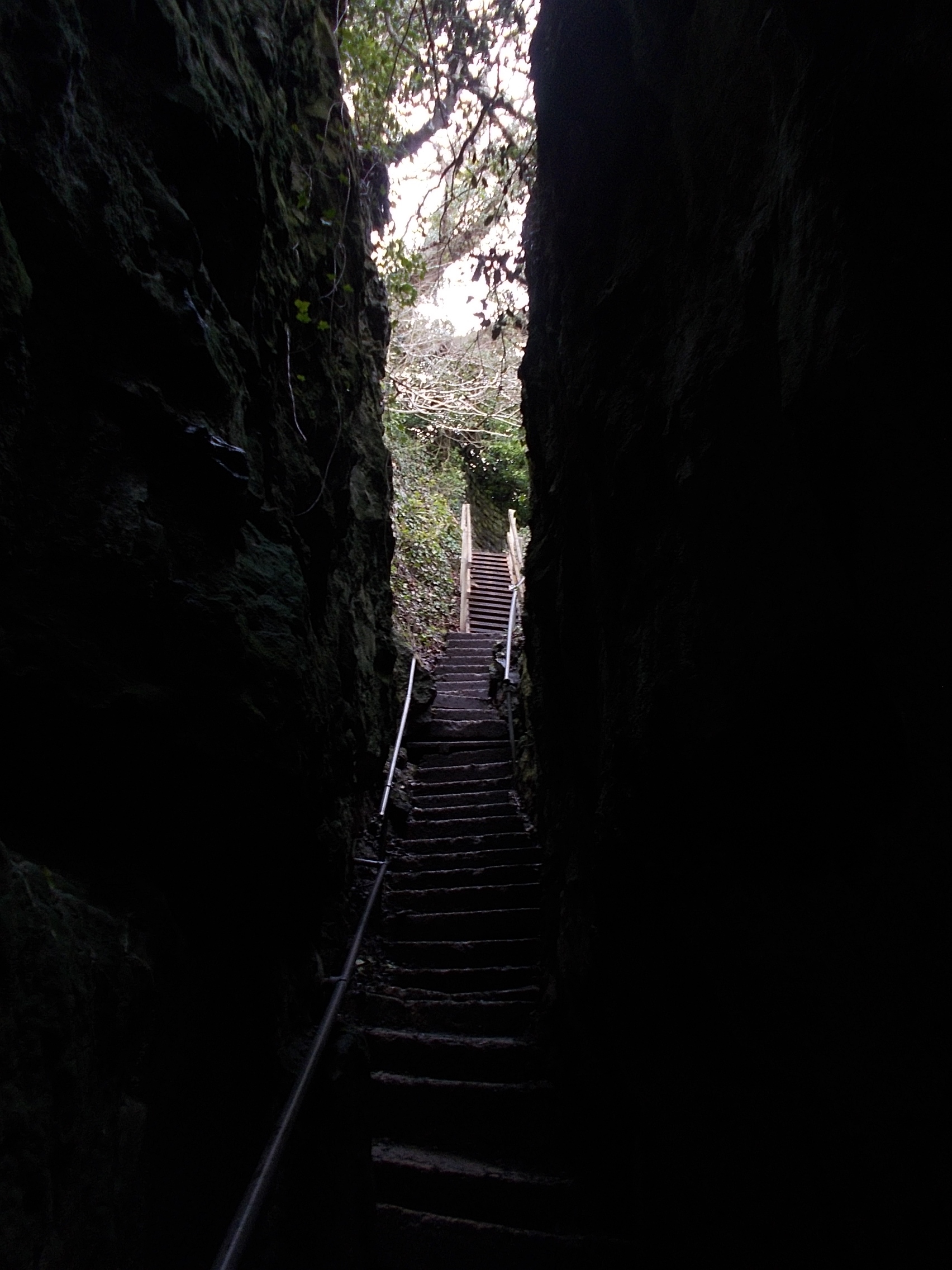
The Devil's Chimney is a scenic rock cleft with steps descending into the Bonchurch Landslips between Bonchurch and Luccombe, Isle of Wight. Its upper end is at the Smuggler's Haven Tearooms on St Boniface Down, at the southern end of clifftop parkland accessed from the Leeson Road car park on the A3055 road, where there is a Southern Vectis bus route 3 stop. One of several such paths connecting the clifftop to the Isle of Wight Undercliff, the Devil's Chimney follows a joint through the Upper Greensand Greensand or green sand is a sand or sandstone which has a greenish color. This term is specifically applied to shallow marine sediment that contains noticeable quantities of rounded greenish grains. These grains are called ''glauconies'' and c ... crags capping the cliffs above the Landslip. The path continues down through the Landslip as footpath V65C, meeting the coastal path V65A at its foot. A similar rock cleft, the Chink, is about 200 yards north. The featu ... [...More Info...] [...Related Items...] OR: [Wikipedia] [Google] [Baidu] |
Bonchurch Landslips
Bonchurch Landslips is a site of special scientific interest which is located north-east of Ventnor, Isle of Wight. A wooded coastal landslip zone, the site was notified in 1977 for both its biological and geological features. Part of the Isle of Wight Undercliff, it is accessed by several footpaths, including V65C, that descends into the landslip via the Devil's Chimney rock cleft; V65, descending via another rock chimney called ' The Chink'; V65b from Ventnor; and V65a from Luccombe. Significance The Bonchurch Landslip (also called East End Landslip) involves a coastal Cretaceous sequence where harder Upper Greensand rocks overlie softer Gault clay. It has SSSI status for its geomorphological interest (the Undercliff itself, and the landslips and mud flows below) and its botanical assemblage. The Gault clay supports established woodland of ash, oak and beech, with unusual lichen species. The lower slips, comprising mixed clay and sandy habitats, support a complex mix of ac ... [...More Info...] [...Related Items...] OR: [Wikipedia] [Google] [Baidu] |
Bonchurch
Bonchurch is a small village to the east of Ventnor, now largely connected to the latter by suburban development, on the southern part of the Isle of Wight, England. One of the oldest settlements on the Isle of Wight, it is situated on Undercliff (Isle of Wight), The Undercliff adjacent to the Bonchurch Landslips (or "The Landslip") Site of Special Scientific Interest. The main village is backed by a cliff to the north, with the Upper Bonchurch section on the clifftop halfway up St Boniface Down on the main A3055 road. Geography Bonchurch is situated on a stable section of former landslip, its main street (Bonchurch Village Road) running east–west in a valley sheltered to the north by cliffs, and to the south by The Mount, a ridge of slipped rock. Bonchurch Village Road has an adjacent landscaped pond, fed by a Spring (hydrology), spring, on the site of former withy beds. The Shanklin-Ventnor route originally passed through Bonchurch, descending the cliff by the steep Bonchurch ... [...More Info...] [...Related Items...] OR: [Wikipedia] [Google] [Baidu] |
Luccombe, Isle Of Wight
Luccombe is a hamlet a short distance south of Shanklin, on the south coast of the Isle of Wight, England. There is some indication of Bronze Age settlements on the top of the nearby hill of Luccombe Down. The Luccombe area features spectacular cliffs and scenery. It is a popular site for hang gliding and paragliding if there is an easterly wind of around 12 mph and it is low water, and on good days flights to Sandown and back can be achieved. Luccombe forms the east end of the Ventnor Undercliff region, which extends for 12 kilometers from Blackgang to Luccombe, also encompassing the town of Ventnor and the villages of Bonchurch, St Lawrence, and Niton. There is some concern that the Ventnor Undercliff area is experiencing substantial coastal erosion. [...More Info...] [...Related Items...] OR: [Wikipedia] [Google] [Baidu] |
Isle Of Wight
The Isle of Wight ( ) is a county in the English Channel, off the coast of Hampshire, from which it is separated by the Solent. It is the largest and second-most populous island of England. Referred to as 'The Island' by residents, the Isle of Wight has resorts that have been popular holiday destinations since Victorian times. It is known for its mild climate, coastal scenery, and verdant landscape of fields, downland and chines. The island is historically part of Hampshire, and is designated a UNESCO Biosphere Reserve. The island has been home to the poets Algernon Charles Swinburne and Alfred, Lord Tennyson. Queen Victoria built her summer residence and final home, Osborne House at East Cowes, on the Isle. It has a maritime and industrial tradition of boat-building, sail-making, the manufacture of flying boats, hovercraft, and Britain's space rockets. The island hosts annual music festivals, including the Isle of Wight Festival, which in 1970 was the largest rock music ... [...More Info...] [...Related Items...] OR: [Wikipedia] [Google] [Baidu] |
St Boniface Down
St Boniface Down is a chalk down near Ventnor, on the Isle of Wight, England. Its summit, , is the highest point on the island, with views stretching from Beachy Head to the east, Portsmouth to the north and the Isle of Portland to the west. It is north of the town. There is reputed to be a wishing well on its southern slope, which requires the wisher to climb up from the south without looking back. In 1545, a French invasion force attempted this against a force of the Isle of Wight Militia commanded by Sir John Fyssher – which allegedly included several women archers- and were routed. In 1940, the radar station was bombed by Ju 87 Stuka dive bombers, which is reconstructed in the film "The Battle of Britain". The top is surmounted by a round barrow. At the eastern foot of the down, on the A3055 road between Bonchurch and Luccombe, a path descends into Bonchurch Landslips via a scenic rock cleft, the Devil's Chimney. Wildlife St Boniface Down is home to the largest c ... [...More Info...] [...Related Items...] OR: [Wikipedia] [Google] [Baidu] |
A3055 Road
The A3055 is an A-Class Road on the Isle of Wight in Southern England. It forms the Southern portion of the ''circular'' around-the-Island A-class loop, the northern section being the A3054. The stretch along the south-west coast of the Island is formed by the Military Road. Because of the road's relatively short length, there are no confirmatory signs with distances, although on a few direction signs at junctions there are distances to the next town. The final destination of the road (Freshwater/Totland or Ryde), in common with most UK roads, is not signed along the whole length of the route. As well as fitting with national practice, this is also because anybody wishing to travel from Totland to Ryde by road would do so via the North coast A3054, as it is much more direct. Numerous landslips have affected the road in recent history, particularly around Undercliff Drive between Ventnor and Niton, which has resulted in sections being closed for repair on several occasions. ... [...More Info...] [...Related Items...] OR: [Wikipedia] [Google] [Baidu] |
Southern Vectis
Southern Vectis is a bus operator on the Isle of Wight. The company was founded in 1921 as "Dodson and Campbell" and became the "Vectis Bus Company" in 1923. The company was purchased by the Southern Railway (Great Britain), Southern Railway before being nationalised in 1969. In 1987, the company was re-privatised. In July 2005, it became a subsidiary of Go-Ahead Group. History 1921–1928 In 1921 in Cowes, the company was founded as "Dodson & Campbell". In 1923, the company was renamed the "Vectis Bus Company". "Vectis" is the Roman name for the Isle of Wight. The buses were built by the London bus body builder, Christopher Dodson. 1929–1985 In 1929, the company was purchased by Southern Railway (Great Britain), Southern Railway and was Incorporation (business), incorporated as "The Southern Vectis Omnibus Company Limited". [...More Info...] [...Related Items...] OR: [Wikipedia] [Google] [Baidu] |
Undercliff (Isle Of Wight)
The Undercliff, Isle of Wight, England is a tract of semi-rural land, around long by wide, skirting the southern coast of the island from Niton to Bonchurch. Named after its position below the escarpment that backs this coastal section, its undulating terrain comprises a mix of rough pasture, secondary woodland, parkland, grounds of large isolated houses, and suburban development. Its sheltered south-facing location gives rise to a microclimate considerably warmer than elsewhere on the island. Although inhabited, the Undercliff is an area prone to landslips and subsidence, with accompanying loss of property over time. Settlements along the Undercliff, from west to east, are: lower Niton (also called Niton Undercliff), Puckaster, St Lawrence, Steephill, the town of Ventnor, and Bonchurch. Geology The Undercliff is a landslide complex in Cretaceous soft rocks, a bench of slipped clays and sands above a low sea-cliff, backed by higher () Upper Greensand and Chalk cliffs. ... [...More Info...] [...Related Items...] OR: [Wikipedia] [Google] [Baidu] |
Greensand (geology)
Greensand or green sand is a sand or sandstone which has a greenish color. This term is specifically applied to shallow marine sediment that contains noticeable quantities of rounded greenish grains. These grains are called ''glauconies'' and consist of a mixture of mixed-layer clay minerals, such as smectite and glauconite. Greensand is also loosely applied to any glauconitic sediment. Formation Greensand forms in anoxic marine environments that are rich in organic detritus and low in sedimentary input. Having accumulated in marine environments, greensands can be fossil-rich, such as in the late-Cretaceous deposits of New Jersey. Occurrence Important exposures are known from both northern and western Europe, North America, southeastern Brazil and north Africa. Well known and important greensands are the Upper and Lower Greensands of England and occur within Eocene and Cretaceous sedimentary strata underlying the coastal plains of New Jersey and Delaware. Although greensand has ... [...More Info...] [...Related Items...] OR: [Wikipedia] [Google] [Baidu] |
Chink (Isle Of Wight)
The Chink is a scenic rock cleft between Bonchurch and Luccombe, Isle of Wight, with steps descending from St Boniface Down to the Bonchurch Landslips below. Its upper end is at the northern end of clifftop parkland accessed from the Leeson Road ( A3055) car park, where there is a Southern Vectis bus route 3 stop. The Chink was known in Victorian times as part of the development of the Bonchurch Landslips as a picturesque woodland walk.Historic Environment Action Plan: The Undercliff Isle of Wight County Archaeology and Historic Environment Service, October 2008 (retrieved 13 July 2013) One of several such paths with carved steps connecting the clifftop to the [...More Info...] [...Related Items...] OR: [Wikipedia] [Google] [Baidu] |
Landforms Of The Isle Of Wight
A landform is a natural or anthropogenic land feature on the solid surface of the Earth or other planetary body. Landforms together make up a given terrain, and their arrangement in the landscape is known as topography. Landforms include hills, mountains, canyons, and valleys, as well as shoreline features such as bays, peninsulas, and seas, including submerged features such as mid-ocean ridges, volcanoes, and the great ocean basins. Physical characteristics Landforms are categorized by characteristic physical attributes such as elevation, slope, orientation, stratification, rock exposure and soil type. Gross physical features or landforms include intuitive elements such as berms, mounds, hills, ridges, cliffs, valleys, rivers, peninsulas, volcanoes, and numerous other structural and size-scaled (e.g. ponds vs. lakes, hills vs. mountains) elements including various kinds of inland and oceanic waterbodies and sub-surface features. Mountains, hills, plateaux, and plains are the fou ... [...More Info...] [...Related Items...] OR: [Wikipedia] [Google] [Baidu] |


.jpg)