|
Côte Vermeille
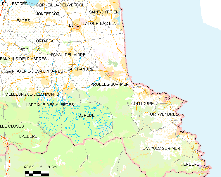
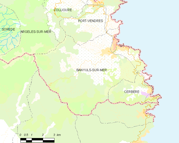
The Côte Vermeille ( ca, Costa Vermella, meaning "vermilion coast") is a region in the French Departments of France, department of Pyrénées-Orientales on the Mediterranean Coast near the border with Spain. The Côte Vermeille stretches from Argelès-sur-Mer to the border village of Cerbère. The towns of Collioure, Port-Vendres and Banyuls-sur-Mer are nested along a 20 km stretch of beaches, small bays, creeks and coves. See also * Paulilles * Natura 2000 * Route départementale 914 Landforms of Pyrénées-Orientales Protected areas of France Northern Catalonia Coasts of France, Vermeille {{Europe-protected-area-stub ... [...More Info...] [...Related Items...] OR: [Wikipedia] [Google] [Baidu] |
Departments Of France
In the administrative divisions of France, the department (french: département, ) is one of the three levels of government under the national level ("territorial collectivities"), between the administrative regions and the communes. Ninety-six departments are in metropolitan France, and five are overseas departments, which are also classified as overseas regions. Departments are further subdivided into 332 arrondissements, and these are divided into cantons. The last two levels of government have no autonomy; they are the basis of local organisation of police, fire departments and, sometimes, administration of elections. Each department is administered by an elected body called a departmental council ( ing. lur.. From 1800 to April 2015, these were called general councils ( ing. lur.. Each council has a president. Their main areas of responsibility include the management of a number of social and welfare allowances, of junior high school () buildings and technical staff, ... [...More Info...] [...Related Items...] OR: [Wikipedia] [Google] [Baidu] |
Pyrénées-Orientales
Pyrénées-Orientales (; ca, Pirineus Orientals ; oc, Pirenèus Orientals ; ), also known as Northern Catalonia, is a department of the region of Occitania, Southern France, adjacent to the northern Spanish frontier and the Mediterranean Sea. It also surrounds the tiny Spanish exclave of Llívia, and thus has two distinct borders with Spain. In 2019, it had a population of 479,979.Populations légales 2019: 66 Pyrénées-Orientales INSEE Some parts of the Pyrénées-Orientales (like the ) are part of the . It is na ... [...More Info...] [...Related Items...] OR: [Wikipedia] [Google] [Baidu] |
Argelès-sur-Mer
Argelès-sur-Mer (, literally ''Argelès on Sea''; ca, Argelers de la Marenda or ; oc, Argelers de Mar), commonly known as Argelès, is a commune in the Pyrénées-Orientales department in the administrative region of Occitania, France. It is about 25 km from Perpignan. Geography Argelès-sur-Mer is located in the canton of La Côte Vermeille and in the arrondissement of Céret. Argelès-sur-Mer is on the Côte Vermeille at the foot of the Albères mountain range, close to the Spanish border. It has the longest beach in the Pyrenées Orientales. History During World War II, Argelès-sur-Mer was the location of a concentration camp, where up to 100,000 defeated Spanish Republicans were interned next to a windy beach in abysmal sanitary conditions by the French government after the defeat of the Spanish Republic. The refugees streamed to the camp from the winter of 1938/39 after the collapse of the Catalan front following the rebel offensive. Government and politics ... [...More Info...] [...Related Items...] OR: [Wikipedia] [Google] [Baidu] |
Cerbère
Cerbère (; ca, Cervera de la Marenda) is a commune and railway town in the Pyrénées-Orientales department in southern France.Commune de Cerbère (66048) INSEE Its inhabitants are called ''Cerbériens'' (''Cerverins'' / ''Cerverines'' in Catalan). The village is best known for the border railway station, , on the French side of the on the railway line between Perpignan and |
Collioure
Collioure (; ca, Cotlliure, ) is a commune in the southern French department of Pyrénées-Orientales. Geography The town of Collioure is on the Côte Vermeille (Vermilion Coast), in the canton of La Côte Vermeille and in the arrondissement of Céret. Toponymy Collioure is named ''Cotlliure'' in Catalan. History There is a record of the castle at "Castrum Caucoliberi" having been mentioned as early as 673, indicating that the settlement here was of strategic and commercial importance during the Visigoth ascendancy. Collioure used to be divided into two villages separated by the river Douy, the old town to the south named ''Port d'Avall'' (in French known as ''Le Faubourg'') and the upstream port, ''Port d'Amunt'' (in French known as ''Le Mouré''). Collioure was taken in 1642 by the French troops of Maréchal de la Meilleraye. A decade later, the town was officially surrendered to France by the 1659 Treaty of Pyrenees. Because of its highly strategic importance, the t ... [...More Info...] [...Related Items...] OR: [Wikipedia] [Google] [Baidu] |
Port-Vendres
Port-Vendres (; ca, Portvendres) is a commune in the Pyrénées-Orientales department, southwestern France. A typical Mediterranean fishing port, situated near the Spanish border on the Côte Vermeille in southwestern France, Port-Vendres is renowned for its numerous fish and sea food restaurants. Geography Port-Vendres is located in the canton of La Côte Vermeille and in the arrondissement of Céret. Port-Vendres is one of the few deep-water ports in this part of the French Mediterranean coast. It takes freighters and cruise ships, as well as large and small fishing boats which may be seen arriving with their daily catch. The geomorphology of Port-Vendres meant that it developed in a different way from the nearby port of Collioure. Whereas Collioure has two beaches which slowly descend into a relatively shallow sandy-bottomed harbour, Port-Vendres is deeper and rockier. Collioure and Port-Vendres have therefore been used for different purposes - Collioure for small com ... [...More Info...] [...Related Items...] OR: [Wikipedia] [Google] [Baidu] |
Banyuls-sur-Mer
Banyuls-sur-Mer (; ) is a commune in the Pyrénées-Orientales department in southern France. It was first settled by Greeks starting in 400 BCE. Geography Location Banyuls-sur-Mer is located in the canton of La Côte Vermeille and in the arrondissement of Céret. Banyuls-sur-Mer is neighbored by Cerbère, Port-Vendres, Argelès-sur-Mer and Collioure on its French borders, and by Espolla, Rabós, Colera and Portbou on its Spanish borders. The foothills of Pyrenees, the ''Monts Albères'', run into the Mediterranean Sea in Banyuls-sur-Mer, creating a steep cliff line. Toponymy Banyuls-sur-Mer was first mentioned in 981 as ''Balneum'' or ''Balneola''. In 1074, the town started being called ''Bannils de Maritimo'' in order to distinguish it from Banyuls-dels-Aspres, which lies away. In 1197, the town was mentioned as ''Banullis de Maredine'' and in 1674. In Catalan, it has been called ''Banyuls de la Marenda'' since the 19th century. The name Banyuls indicates the presence ... [...More Info...] [...Related Items...] OR: [Wikipedia] [Google] [Baidu] |
Panorama Côte Vermeille
A panorama (formed from Greek πᾶν "all" + ὅραμα "view") is any wide-angle view or representation of a physical space, whether in painting, drawing, photography, film, seismic images, or 3D modeling. The word was originally coined in the 18th century by the English (Irish descent) painter Robert Barker to describe his panoramic paintings of Edinburgh and London. The motion-picture term ''panning'' is derived from ''panorama''. A panoramic view is also purposed for multimedia, cross-scale applications to an outline overview (from a distance) along and across repositories. This so-called "cognitive panorama" is a panoramic view over, and a combination of, cognitive spaces used to capture the larger scale. History The device of the panorama existed in painting, particularly in murals, as early as 20 A.D., in those found in Pompeii, as a means of generating an immersive "panoptic" experience of a vista. Cartographic experiments during the Enlightenment era precede ... [...More Info...] [...Related Items...] OR: [Wikipedia] [Google] [Baidu] |
Paulilles
Paulilles is a protected area on the Mediterranean Sea, located between the towns of Port-Vendres, and Banyuls-sur-Mer in Pyrénées-Orientales, North Catalonia, France. History The Dynamite Factory Paulilles Recreational Park occupies a rehabilitated dynamite factory site protected as an ecological network by the Natura 2000 European organisation. Originally serving as the French Nobel Dynamite Factory, it was created by Nobel's associate in France, Paul François Barbe, and built in 1870. Several accidents over the years caused multiple deaths: the most important ones killed 20 workers in 1882 and 5 in 1885. Protecting the environment In July 1991, the installations were closed by the Société nationale des poudres et des explosifs (SNPE), and later sold to the Conservatoire du littoral in 1998 to protect the area from real estate developers. In 2005, the General Council of the Pyrénées-Orientales launched the renovation to ready 9 buildings, destroy nearly 70, and lan ... [...More Info...] [...Related Items...] OR: [Wikipedia] [Google] [Baidu] |
Natura 2000
Natura 2000 is a network of nature protection areas in the territory of the European Union. It is made up of Special Areas of Conservation and Special Protection Areas designated under the Habitats Directive and the Birds Directive, respectively. The network includes both terrestrial and Marine Protected Areas. History In May 1992, the governments of the European Communities adopted legislation designed to protect the most seriously threatened habitats and species across Europe. The Habitats Directive complements the Birds Directive adopted earlier in 1979 and together they make up the Natura 2000 network of protected areas. The Birds Directive requires the establishment of Special Protection Areas for birds. The Habitats Directive similarly requires Sites of Community Importance which upon the agreement of the European Commission become Special Areas of Conservation to be designated for species other than birds, and for habitat types (e.g. particular types of forest, grassland ... [...More Info...] [...Related Items...] OR: [Wikipedia] [Google] [Baidu] |
Route Départementale 914
The Route Départementale 914 or RD 914 is the scenic route by the Mediterranean Sea, between Perpignan and Cerbère, at the Spanish border. Formerly named Route Nationale 114, or RN 114 before being handed to the département of Pyrénées-Orientales, on December 9 2005. It becomes the Spanish National Road N-260 or Eix Pirenenc (in Catalan) as it crosses the border toward Portbou. The N-260 is about to be upgraded into a highway, the "Autovía del Eje Pirenaico" (in Spanish) or "Autovia del Eix Pirenenc" (in Catalan), the Autovía A-26.See the Route Départementale 914 on GoogleMaps From Perpignan to Cerbère * Perpignan ''(km 0)'' * Corneilla-del-Vercol * Elne ''(km 13)'' * Argelès-sur-Mer ''(km 21)'' * Collioure ''(km 27)'' * Port-Vendres ''(km 30)'' * ''Paulilles'' ''(km 33)'' * Banyuls-sur-Mer ''(km 36)'' * Cerbère ''(km 45)'' * ''Col des Balistres'' See also * Côte Vermeille 914 __NOTOC__ Year 914 ( CMXIV) was a common year starting on Saturday (link wi ... [...More Info...] [...Related Items...] OR: [Wikipedia] [Google] [Baidu] |
Landforms Of Pyrénées-Orientales
A landform is a natural or anthropogenic land feature on the solid surface of the Earth or other planetary body. Landforms together make up a given terrain, and their arrangement in the landscape is known as topography. Landforms include hills, mountains, canyons, and valleys, as well as shoreline features such as bays, peninsulas, and seas, including submerged features such as mid-ocean ridges, volcanoes, and the great ocean basins. Physical characteristics Landforms are categorized by characteristic physical attributes such as elevation, slope, orientation, stratification, rock exposure and soil type. Gross physical features or landforms include intuitive elements such as berms, mounds, hills, ridges, cliffs, valleys, rivers, peninsulas, volcanoes, and numerous other structural and size-scaled (e.g. ponds vs. lakes, hills vs. mountains) elements including various kinds of inland and oceanic waterbodies and sub-surface features. Mountains, hills, plateaux, and plains are ... [...More Info...] [...Related Items...] OR: [Wikipedia] [Google] [Baidu] |


.jpg)