|
Cyclone Viyaru
Cyclonic Storm Viyaru, operationally known as Cyclonic Storm Mahasen, was a relatively weak tropical cyclone that caused loss of life across six countries in Southern and Southeastern Asia. Originating from an area of low pressure over the southern Bay of Bengal in early May 2013, Viyaru slowly consolidated into a depression on May 10. The depression gained forward momentum and attained gale-force winds on May 11 and was designated as Cyclonic Storm Viyaru, the first named storm of the season. Owing to adverse atmospheric conditions, the depression struggled to maintain organized convection as it moved closer to eastern India. On May 14, the exposed circulation of Viyaru turned northeastward. The following day, conditions again allowed for the storm to intensify. Early on May 16, the cyclone attained its peak intensity with winds of and a barometric pressure of 990 mbar (hPa; ). Shortly thereafter Viyaru made landfall near Chittagong, Bangladesh. On May 17, ... [...More Info...] [...Related Items...] OR: [Wikipedia] [Google] [Baidu] |
Bangladesh
Bangladesh (}, ), officially the People's Republic of Bangladesh, is a country in South Asia. It is the eighth-most populous country in the world, with a population exceeding 165 million people in an area of . Bangladesh is among the most densely populated countries in the world, and shares land borders with India to the west, north, and east, and Myanmar to the southeast; to the south it has a coastline along the Bay of Bengal. It is narrowly separated from Bhutan and Nepal by the Siliguri Corridor; and from China by the Indian state of Sikkim in the north. Dhaka, the capital and largest city, is the nation's political, financial and cultural centre. Chittagong, the second-largest city, is the busiest port on the Bay of Bengal. The official language is Bengali, one of the easternmost branches of the Indo-European language family. Bangladesh forms the sovereign part of the historic and ethnolinguistic region of Bengal, which was divided during the Partition of India in ... [...More Info...] [...Related Items...] OR: [Wikipedia] [Google] [Baidu] |
Bangladeshi Taka
The Bangladeshi taka ( bn, টাকা, currency sign, sign: , ISO 4217, code: BDT, Short form (linguistics), short form: Tk) is the currency of the Bangladesh, People's Republic of Bangladesh. In Unicode, it is encoded at . Issuance of bank notes 10 and larger is controlled by Bangladesh Bank, while the 2 and 5 banknotes are the responsibility of the Ministry of Finance (Bangladesh), ministry of finance of the government of Bangladesh. The banknotes of Tk. 2 and Tk.5 have mostly been replaced by coins while lower denomination coins (including all poysha coins) up to Tk. 1 have almost gone out of circulation due to inflation. The most commonly used symbol for the taka is "" and "Tk", used on receipts while purchasing goods and services. It was formerly divided into 100 paisa, poysha, but poysha coins are no longer in circulation. Etymology According to ''The American Heritage Dictionary of the English Language'' and ''Banglapedia'', the word ''taka'' came from the Sanskrit ... [...More Info...] [...Related Items...] OR: [Wikipedia] [Google] [Baidu] |
Tropical Cyclone Formation Alert
A Tropical Cyclone Formation Alert (TCFA) is a bulletin released by the U.S. Navy-operated Joint Typhoon Warning Center in Honolulu, Hawaii or the Fleet Weather Center in Norfolk, Virginia, warning of the possibility of a tropical cyclone forming from a tropical disturbance that has been monitored. Such alerts are generally always issued when it is fairly certain that a tropical cyclone will form and are not always released before cyclone genesis, particularly if the cyclone appears suddenly. The TCFA consists of several different checks that are performed by the on-duty meteorologist of the system and its surroundings. If the condition being checked is met, a certain number of points are given to the system. Parts of the TCFA Section 1 The first section of the TCFA contains information on the area of the alert as well as the estimated center of the circulation. The estimated maximum sustained winds are provided as well. Section 2 The second section generally contains more specif ... [...More Info...] [...Related Items...] OR: [Wikipedia] [Google] [Baidu] |
Joint Typhoon Warning Center
The Joint typhoon Warning Center (JTWC) is a joint United States Navy – United States Air Force command in Pearl Harbor, Hawaii. The JTWC is responsible for the issuing of tropical cyclone warnings in the North-West Pacific Ocean, South Pacific Ocean, and Indian Ocean for all branches of the U.S. Department of Defense and other U.S. government agencies. Their warnings are intended for the protection of primarily military ships and aircraft as well as military installations jointly operated with other countries around the world. Its U.S. Navy components are aligned with the Naval Meteorology and Oceanography Command. History The origins of the Joint Typhoon Warning Center (JTWC) can be traced back to June 1945, when the Fleet Weather Center/Typhoon Tracking Center was established on the island of Guam, after multiple typhoons, including Typhoon Cobra of December 1944 and Typhoon Connie in June 1945, had caused a significant loss of men and ships. At this time the center ... [...More Info...] [...Related Items...] OR: [Wikipedia] [Google] [Baidu] |
Tropical Storm Jamala (2013)
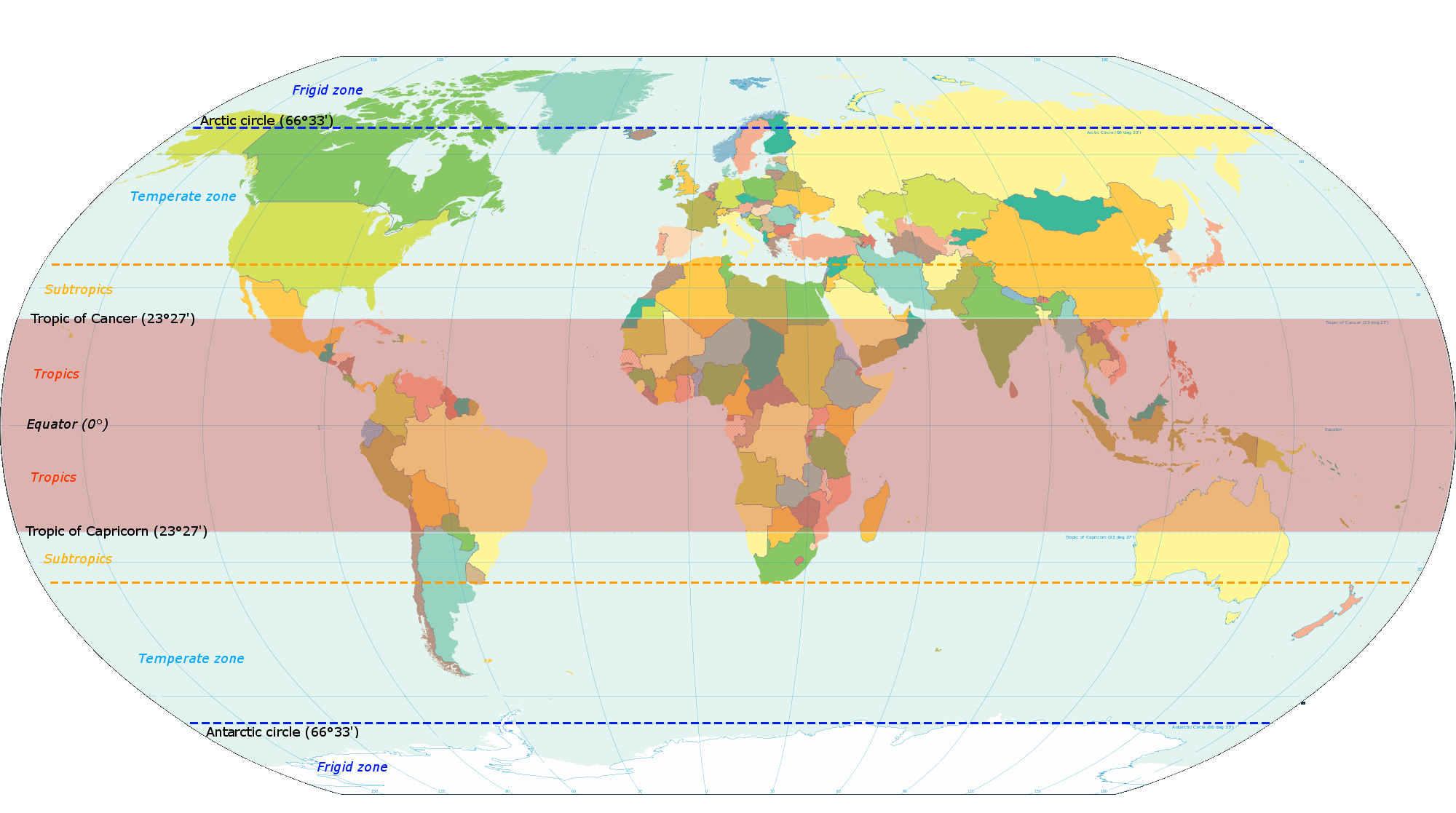
The tropics are the regions of Earth surrounding the Equator. They are defined in latitude by the Tropic of Cancer in the Northern Hemisphere at N and the Tropic of Capricorn in the Southern Hemisphere at S. The tropics are also referred to as the tropical zone and the torrid zone (see geographical zone). In terms of climate, the tropics receive sunlight that is more direct than the rest of Earth and are generally hotter and wetter as they aren't affected as much by the solar seasons. The word "tropical" sometimes refers to this sort of climate in the zone rather than to the geographical zone itself. The tropical zone includes deserts and snow-capped mountains, which are not tropical in the climatic sense. The tropics are distinguished from the other climatic and biomatic regions of Earth, which are the middle latitudes and the polar regions on either side of the equatorial zone. The tropics constitute 40% of Earth's surface area and contain 36% of Earth's landmass. , the ... [...More Info...] [...Related Items...] OR: [Wikipedia] [Google] [Baidu] |
Kelvin Wave
A Kelvin wave is a wave in the ocean or atmosphere that balances the Earth's Coriolis force against a topographic boundary such as a coastline, or a waveguide such as the equator. A feature of a Kelvin wave is that it is non-dispersive, i.e., the phase speed of the wave crests is equal to the group speed of the wave energy for all frequencies. This means that it retains its shape as it moves in the alongshore direction over time. A Kelvin wave (fluid dynamics) is also a long scale perturbation mode of a vortex in superfluid dynamics; in terms of the meteorological or oceanographical derivation, one may assume that the meridional velocity component vanishes (i.e. there is no flow in the north–south direction, thus making the momentum and continuity equations much simpler). This wave is named after the discoverer, Lord Kelvin (1879). Coastal Kelvin wave In a stratified ocean of mean depth ''H'', perturbed by some amount ''η'', free waves propagate along coastal boundaries (and ... [...More Info...] [...Related Items...] OR: [Wikipedia] [Google] [Baidu] |
Madden–Julian Oscillation
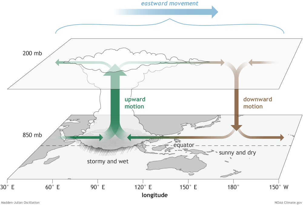
The Madden–Julian oscillation (MJO) is the largest element of the intraseasonal (30- to 90-day) variability in the tropical atmosphere. It was discovered in 1971 by Roland Madden and Paul Julian of the American National Center for Atmospheric Research (NCAR). It is a large-scale coupling between atmospheric circulation and tropical deep atmospheric convection. Unlike a standing pattern like the El Niño–Southern Oscillation (ENSO), the Madden–Julian oscillation is a traveling pattern that propagates eastward, at approximately , through the atmosphere above the warm parts of the Indian and Pacific oceans. This overall circulation pattern manifests itself most clearly as anomalous rainfall. The Madden–Julian oscillation is characterized by an eastward progression of large regions of both enhanced and suppressed tropical rainfall, observed mainly over the Indian and Pacific Ocean. The anomalous rainfall is usually first evident over the western Indian Ocean, and remains evi ... [...More Info...] [...Related Items...] OR: [Wikipedia] [Google] [Baidu] |
Sea Surface Temperature
Sea surface temperature (SST), or ocean surface temperature, is the ocean temperature close to the surface. The exact meaning of ''surface'' varies according to the measurement method used, but it is between and below the sea surface. Air masses in the Earth's atmosphere are highly modified by sea surface temperatures within a short distance of the shore. Localized areas of heavy snow can form in bands downwind of warm water bodies within an otherwise cold air mass. Warm sea surface temperatures are known to be a cause of tropical cyclogenesis over the Earth's oceans. Tropical cyclones can also cause a cool wake, due to turbulent mixing of the upper of the ocean. SST changes diurnally, like the air above it, but to a lesser degree. There is less SST variation on breezy days than on calm days. In addition, ocean currents such as the Atlantic Multidecadal Oscillation (AMO), can affect SST's on multi-decadal time scales, a major impact results from the global thermohaline ci ... [...More Info...] [...Related Items...] OR: [Wikipedia] [Google] [Baidu] |
Outflow (meteorology)
Outflow, in meteorology, is air that flows outwards from a storm system. It is associated with ridging, or anticyclonic flow. In the low levels of the troposphere, outflow radiates from thunderstorms in the form of a wedge of rain-cooled air, which is visible as a thin rope-like cloud on weather satellite imagery or a fine line on weather radar imagery. For observers on the ground, a thunderstorm outflow boundary often approaches in otherwise clear skies as a low, thick cloud that brings with it a gust front. Low-level outflow boundaries can disrupt the center of small tropical cyclones. However, outflow aloft is essential for the strengthening of a tropical cyclone. If this outflow is restricted or undercut, the tropical cyclone weakens. If two tropical cyclones are in close proximity, the upper-level outflow from the upwind system can limit the development of the other system. Thunderstorms For thunderstorms, outflow tends to indicate the development of a system. Large quan ... [...More Info...] [...Related Items...] OR: [Wikipedia] [Google] [Baidu] |
Wind Shear
Wind shear (or windshear), sometimes referred to as wind gradient, is a difference in wind speed and/or direction over a relatively short distance in the atmosphere. Atmospheric wind shear is normally described as either vertical or horizontal wind shear. Vertical wind shear is a change in wind speed or direction with a change in altitude. Horizontal wind shear is a change in wind speed with a change in lateral position for a given altitude. Wind shear is a microscale meteorological phenomenon occurring over a very small distance, but it can be associated with mesoscale or synoptic scale weather features such as squall lines and cold fronts. It is commonly observed near microbursts and downbursts caused by thunderstorms, fronts, areas of locally higher low-level winds referred to as low-level jets, near mountains, radiation inversions that occur due to clear skies and calm winds, buildings, wind turbines, and sailboats. Wind shear has significant effects on the control of a ... [...More Info...] [...Related Items...] OR: [Wikipedia] [Google] [Baidu] |
Rainband
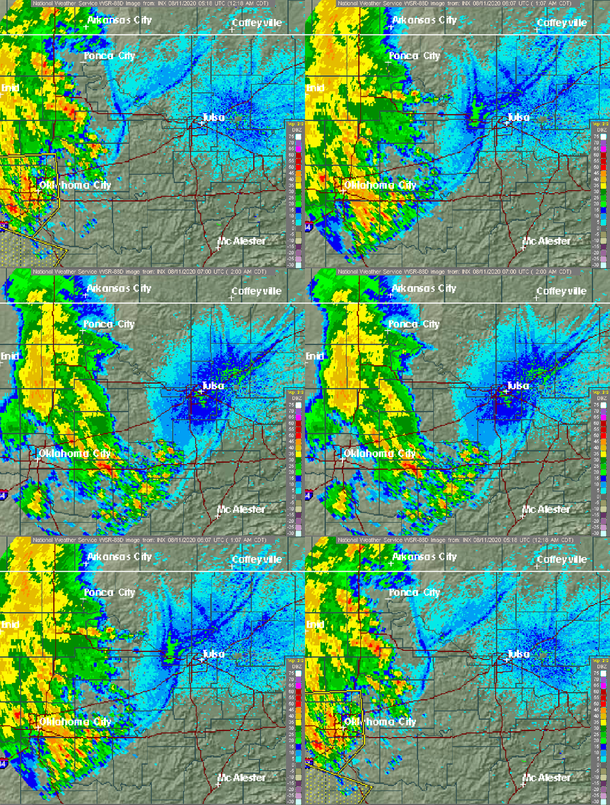
A rainband is a cloud and precipitation structure associated with an area of rainfall which is significantly elongated. Rainbands can be stratiform or convective, and are generated by differences in temperature. When noted on weather radar imagery, this precipitation elongation is referred to as banded structure. Rainbands within tropical cyclones are curved in orientation. Rainbands of tropical cyclones contain showers and thunderstorms that, together with the eyewall and the eye, constitute a hurricane or tropical storm. The extent of rainbands around a tropical cyclone can help determine the cyclone's intensity. Rainbands spawned near and ahead of cold fronts can be squall lines which are able to produce tornadoes. Rainbands associated with cold fronts can be warped by mountain barriers perpendicular to the front's orientation due to the formation of a low-level barrier jet. Bands of thunderstorms can form with sea breeze and land breeze boundaries, if enough moisture ... [...More Info...] [...Related Items...] OR: [Wikipedia] [Google] [Baidu] |
Low-pressure Area
In meteorology, a low-pressure area, low area or low is a region where the atmospheric pressure is lower than that of surrounding locations. Low-pressure areas are commonly associated with inclement weather (such as cloudy, windy, with possible rain or storms), while high-pressure areas are associated with lighter winds and clear skies. Winds circle anti-clockwise around lows in the northern hemisphere, and clockwise in the southern hemisphere, due to opposing Coriolis force, Coriolis forces. Low-pressure systems form under areas of wind divergence that occur in the upper levels of the Atmosphere of Earth, atmosphere (aloft). The formation process of a low-pressure area is known as cyclogenesis. In Meteorology#Dynamic meteorology, meteorology, atmospheric divergence aloft occurs in two kinds of places: * The first is in the area on the east side of upper Trough (meteorology), troughs, which form half of a Rossby wave within the Westerlies (a trough (meteorology), trough with la ... [...More Info...] [...Related Items...] OR: [Wikipedia] [Google] [Baidu] |


