|
Cyclone Kimi
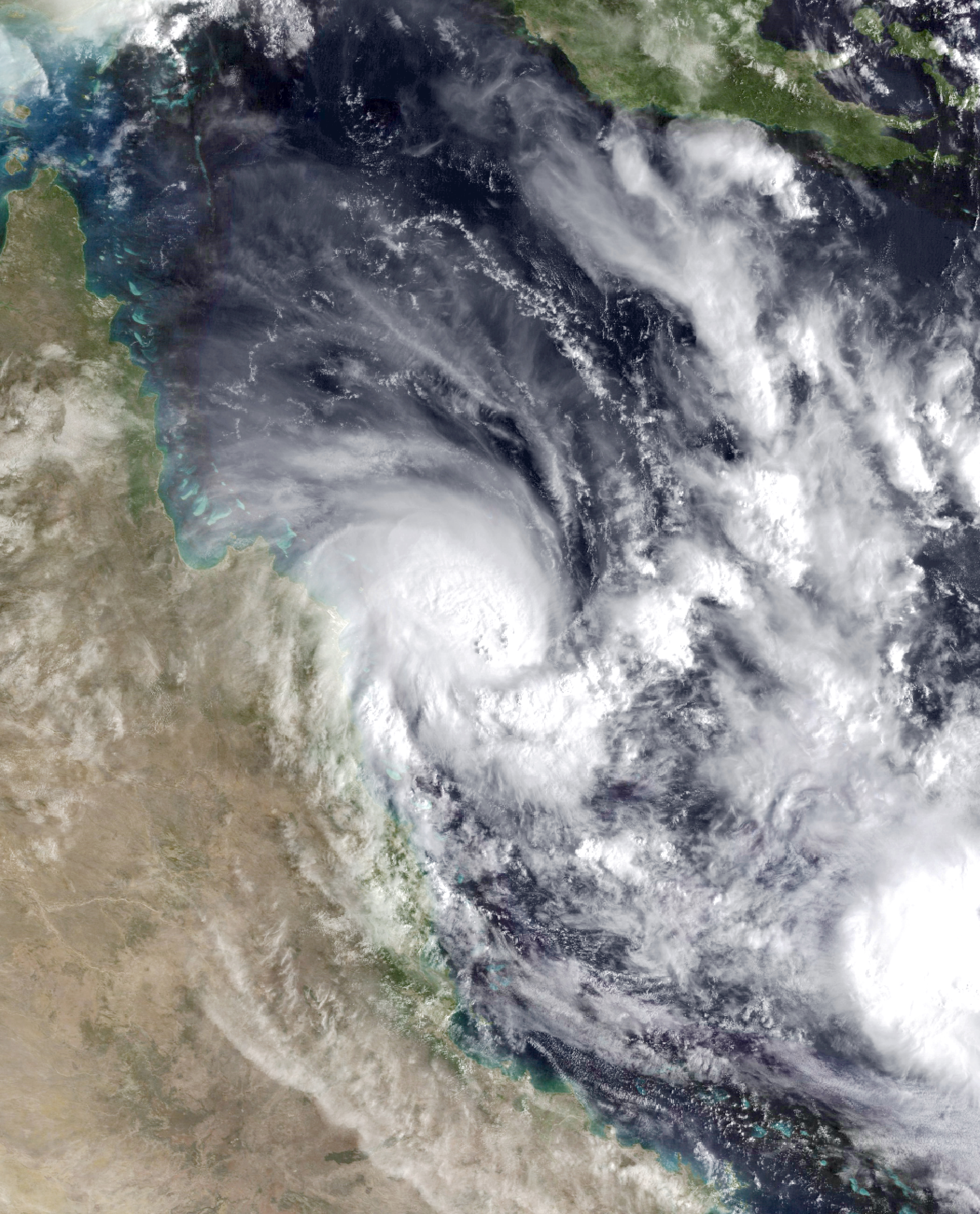
Tropical Cyclone Kimi was a small tropical cyclone which briefly threatened the Eastern Coast of North Queensland in January 2021. The tenth tropical low and third tropical cyclone of the 2020–21 Australian region cyclone season, Kimi originated from a weak tropical low which formed northeast of Queensland on 16 January. The low strengthened into Tropical Cyclone Kimi early the next day, as it slowly moved towards the coastline of northeastern Australia. Despite most forecasts depicting a track south into the coast, a vigorous increase in wind shear made the storm shift west away from the coastline just hours ahead of a potential landfall and caused Kimi to significantly weaken, becoming a tropical low by 18 January and dissipating entirely the next day. Preparations of the storm begun shortly after formation, with watches and warnings being issued for the land in the path of Kimi. Impacts were anticipated to be significant, with the effects of the previous storm to hit the stat ... [...More Info...] [...Related Items...] OR: [Wikipedia] [Google] [Baidu] |
Coral Sea
The Coral Sea () is a marginal sea of the South Pacific off the northeast coast of Australia, and classified as an interim Australian bioregion. The Coral Sea extends down the Australian northeast coast. Most of it is protected by the French Natural Park of the Coral Sea (french: Parc Naturel de la Mer de Corail) and the Australian Coral Sea Marine Park. The sea was the location for the Battle of the Coral Sea, a major confrontation during World War II between the navies of the Empire of Japan, and the United States and Australia. The sea contains numerous islands and reefs, as well as the world's largest reef system, the Great Barrier Reef (GBR), which was declared a World Heritage Site by UNESCO in 1981. All previous oil exploration projects were terminated at the GBR in 1975, and fishing is restricted in many areas. The reefs and islands of the Coral Sea are particularly rich in birds and aquatic life and are a popular tourist destination, both domestically and internat ... [...More Info...] [...Related Items...] OR: [Wikipedia] [Google] [Baidu] |
Cape Melville
Cape Melville is a headland on the eastern coast of the Cape York Peninsula in Australia. To its west lies Princess Charlotte Bay. It is part of the Cape Melville National Park. Cape Melville was named Stoney Cape in 1815 by Lieutenant Charles Jeffreys on the HM Kangaroo but later renamed by him as Cape Melville Pipon Island is about six km north of the cape and Hales Island about two km east, both part of the Great Barrier Reef Marine Park. King Island lies several kilometres to the north west of the cape. The highest peak on the cape is Abbey Peak, which named in 1901 by Commander Munro. R.N., while aboard . The cape consists of granite outcrops which formed 250 million years ago. Unique ecosystem The headland has been described as a "lost world". Several animal species have existed in an isolated section of rainforest for millions of years. A field of granite boulders has prevented bushfires from affecting the area and kept moisture in. In March 2013, ... [...More Info...] [...Related Items...] OR: [Wikipedia] [Google] [Baidu] |
Half Moon Bay, Auckland
Half Moon Bay, an affluent coastal suburb of Auckland, New Zealand, lies immediately south of Bucklands Beach. It formed part of Manukau City until the amalgamation of the entire Auckland Region in 2010 under one governing authority, Auckland Council. It is well known for the Half Moon Bay Marina, home to over 500 boats. It is located on the Tamaki Estuary in the Hauraki Gulf. Half Moon Bay is the location of a long-established ferry terminal for vehicle and passenger traffic to Waiheke Island and for a regular passenger ferry service to downtown Auckland. Demographics Half Moon Bay covers and had an estimated population of as of with a population density of people per km2. Half Moon Bay had a population of 8,106 at the 2018 New Zealand census, an increase of 300 people (3.8%) since the 2013 census, and an increase of 681 people (9.2%) since the 2006 census. There were 2,604 households, comprising 4,074 males and 4,035 females, giving a sex ratio of 1.01 males pe ... [...More Info...] [...Related Items...] OR: [Wikipedia] [Google] [Baidu] |
Innisfail, Queensland
Innisfail (from Irish: Inis Fáil) is a regional town and locality in the Cassowary Coast Region, Queensland, Australia. The town was originally called Geraldton until 1910. In the , the town of Innisfail had a population of 7,236 people, while the locality of Innisfail had a population of 1,145 people. Innisfail is the major township of the Cassowary Coast Region and is known for its sugar and banana industries, as well as for being one of Australia's wettest towns. In March 2006, Innisfail gained worldwide attention when severe Tropical Cyclone Larry passed over causing extensive damage. Geography Innisfail's town centre is situated at the junction of the Johnstone River and South Johnstone River, approximately from the coast. It is located near large tracts of old-growth tropical rainforest surrounded by vast areas of extensive farmlands. Queensland's highest mountain, Mount Bartle Frere; part of Australia's Great Dividing Range, is to the north. The town's central bu ... [...More Info...] [...Related Items...] OR: [Wikipedia] [Google] [Baidu] |
Port Douglas
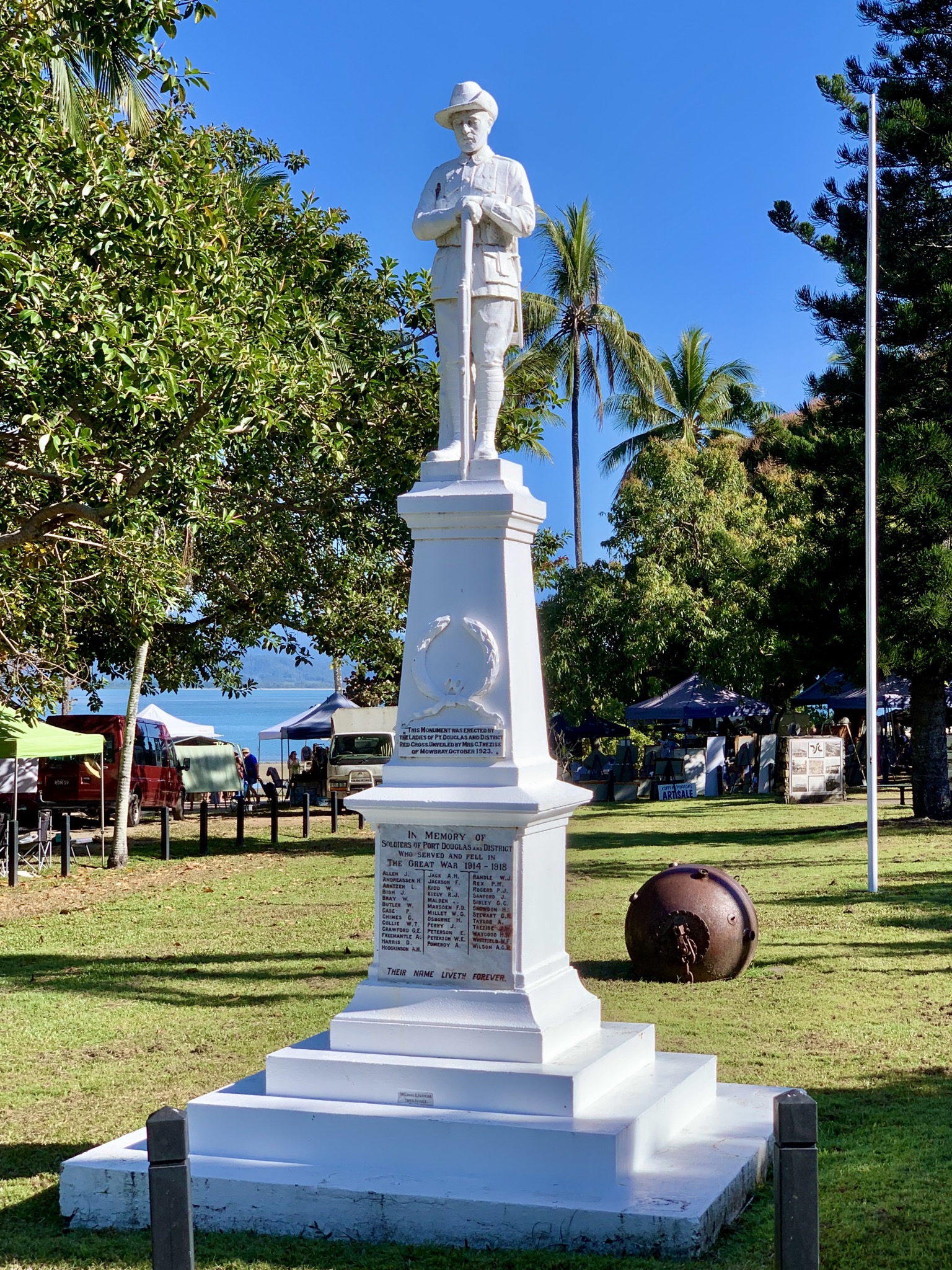
Port Douglas is a coastal town and locality in the Shire of Douglas, Queensland, Australia, approximately 60 km north of Cairns. In the , Port Douglas had a population of 3,504 people. The town's population can often double, however, with the influx of tourists during the peak tourism season from May to September. The town is named in honour of a former Premier of Queensland, John Douglas. Port Douglas developed quickly based on the mining industry. Other parts of the area were established with timber cutting occurring in the area surrounding the Daintree River and with settlement starting to occur on lots around the Mossman River by 1880. Previous names for the town included Terrigal, Island Point, Port Owen and Salisbury. The town is situated adjacent to two World Heritage areas, the Great Barrier Reef and the Daintree Rainforest. Port Douglas was No. 3 on Australian Traveller magazine's list of 100 Best Towns in Australia."100 Best Towns in Australia". Retrieved 21 July 201 ... [...More Info...] [...Related Items...] OR: [Wikipedia] [Google] [Baidu] |
Fitzroy Island (Queensland)
Fitzroy Island (originally ''Koba'' or ''Gabar'') is a continental island offshore from Cape Grafton, 29 km (18 miles) south-east of Cairns, Queensland, Australia. It is a locality in the Cairns Region. In the Fitzroy Island had a population of 44 people. Geography Fitzroy Island is a large tropical island, with a rainforest covering and its own fringe coral reef system. The island has a total area of 339 hectares (838 acres). The highest point of the island is 269 metres (883') above sea level. Fitzroy Island is a 45-minute ferry ride (about 30 km; 20 miles) from Cairns and is surrounded by a reef system that forms part of the Great Barrier Reef Marine Park. Nearly all of the continental island is protected within the Fitzroy Island National Park. It is covered in tropical rainforest. Four walking tracks have been established. Climate Fitzroy enjoys a typical North Queensland tropical climate but with the added advantage of the cooling effects of the ... [...More Info...] [...Related Items...] OR: [Wikipedia] [Google] [Baidu] |
Daintree River Ferry
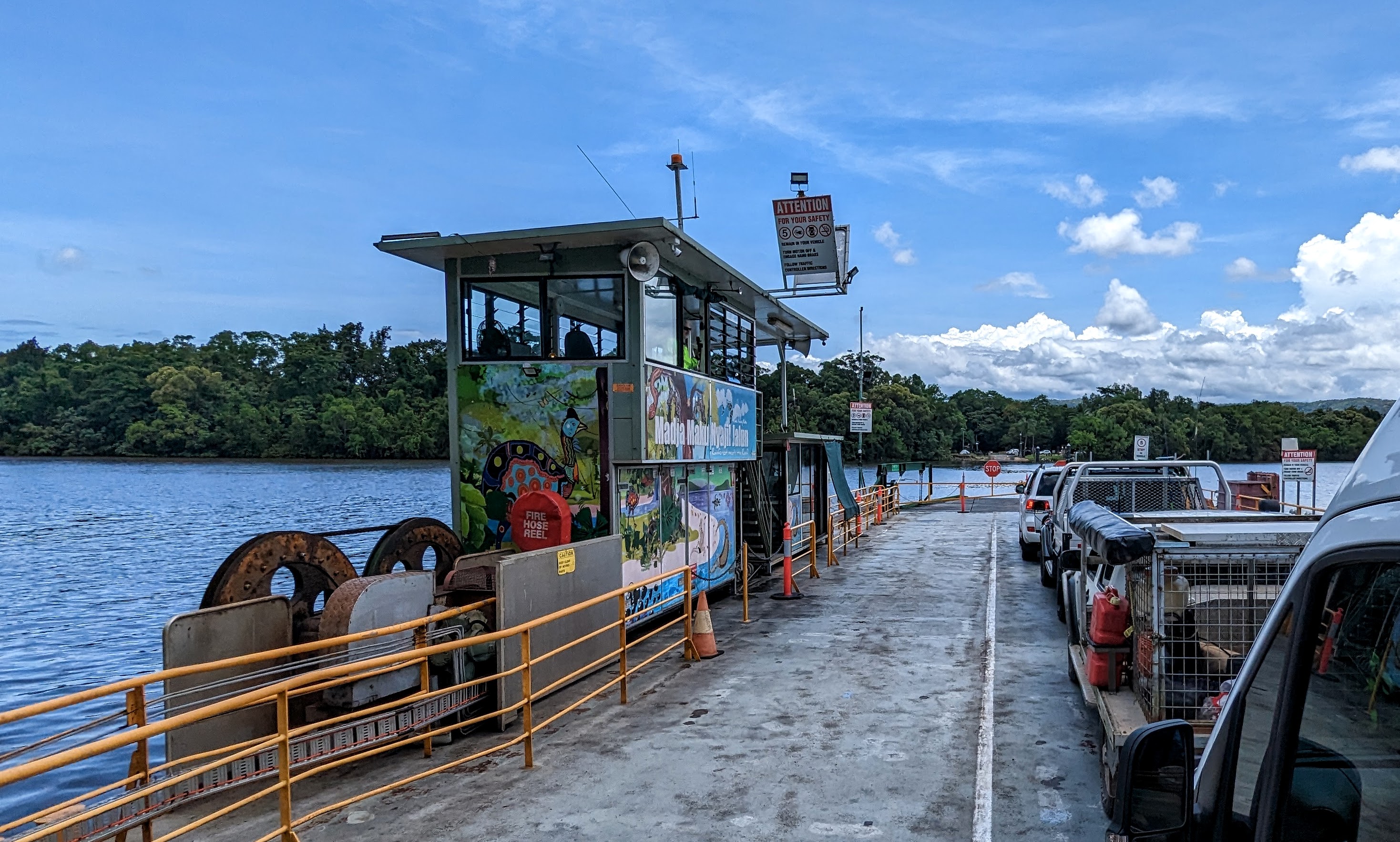
The Daintree River Ferry is a cable ferry across the Daintree River in Queensland, Australia. The ferry is situated some north of Port Douglas, and gives access to the northern section of the Daintree National Park and to Cape Tribulation. The ferry provides the only sealed road access to this area. The 43.2m ferry carries a maximum of 27 vehicles, and takes about 5 minutes to cross the river. It operates from early morning until midnight, seven days a week, with limited hours on Christmas Day. The ferry is operated by a commercial contractor on behalf of the Douglas Shire Council. A toll Toll may refer to: Transportation * Toll (fee) a fee charged for the use of a road or waterway ** Road pricing, the modern practice of charging for road use ** Road toll (historic), the historic practice of charging for road use ** Shadow toll, ... is charged for the crossing, $30.- return for a car in 2019 but this toll keeps rising every year, managed through the local council's Fer ... [...More Info...] [...Related Items...] OR: [Wikipedia] [Google] [Baidu] |
Flecker Botanical Gardens
Flecker Botanic Gardens is a heritage-listed botanic garden at Collins Avenue, Edge Hill, Queensland, Australia. It was built from 1886 to 1960s. It is now known as Cairns Botanic Gardens, and also known as Edge Hill Nursery, and Fitzalan's Botanical Gardens. It was added to the Queensland Heritage Register on 2 February 2007. History The Flecker Botanic Gardens, a public reserve south of Mt Islay in the Mt Whitfield Range, was established in the mid-1880s as part of a recreation reserve, just a decade after the town of Cairns was first surveyed in 1876 as a port to service the Hodgkinson goldfield. Although never officially gazetted for botanic garden purposes, botanic gardens were developed in the recreation reserve at its inception. The work of botanist Eugene Fitzalan in the 1880s and 1890s, Cairns City Council nurserymen and curators from the 1920s and naturalist Dr Hugo Flecker from the 1930s to the 1950s, has contributed to the development of the gardens as a signi ... [...More Info...] [...Related Items...] OR: [Wikipedia] [Google] [Baidu] |
Cairns Central
Cairns Central Shopping Centre is in Cairns City, Cairns, Far North Queensland, Australia. It is Cairns' biggest shopping centre. The centre was opened in late 1997 and is the second multi-story shopping centre in northern Queensland. The shopping centre is built over the Cairns railway station, which is incorporated with the centre. Pedestrian access to the station is through the car park on the bottom floor, or a pedestrian walkway on the second floor. Construction of the shopping centre was delayed temporarily due to damage suffered from Tropical Cyclone Justin in early 1997. Cairns Central currently contains 5 anchor stores including: * 1 Floor Myer department Store. * Target discount department store. The store temporarily pulled out of the centre in April 2021 to swap locations with Kmart. The store opened in November 2021. * Kmart discount department store. It originally opened in the former Bi-Lo supermarket until it was moved into the former Target space in 2021. ... [...More Info...] [...Related Items...] OR: [Wikipedia] [Google] [Baidu] |
Flood Watch
Flood alerts are issued by weather agencies to alert residents that flood conditions are a possibility. Types of flood alerts in the United States In the United States, a flash flood watch is issued by the National Weather Service (NWS) when weather conditions are favorable for very heavy rain that could cause flooding or flash flooding. A watch does not mean that flooding is occurring, only that weather conditions have created or will create a significant risk for it. If flooding occurs, a flood warning or flash flood warning would be issued and immediate action should be taken. A flood warning or flash flood warning is issued when flooding is imminent or already occurring. When flood warnings are issued, it means that area waterways will likely soon be in flood. Not all flood watches suggest that large-scale flooding, such as during landfalling tropical cyclones, is possible. Flood alerts in other countries In Canada, a heavy rainfall warning, which indicates rainfall amounts t ... [...More Info...] [...Related Items...] OR: [Wikipedia] [Google] [Baidu] |
Bowen, Queensland
Bowen is a coastal town and locality in the Whitsunday Region, Queensland, Australia. In the , the locality of Bowen had a population of 10,377 people. The locality contains two other towns: * Heronvale () * Merinda (). The Abbot Point coal shipping port is also within the locality (). Geography Bowen is located on the north-east coast in North Queensland, at exactly twenty degrees south of the equator. Bowen is halfway between Townsville and Mackay, and by road from Brisbane. Bowen sits on a square peninsula, with the Coral Sea to the north, east, and south. To the south-east is Port Denison and Edgecumbe Bay. On the western side, where the peninsula connects with the mainland, the Don River's alluvial plain provides fertile soil that supports a prosperous farming industry. Merinda is a hinterland town west of the town of Bowen. The Bruce Highway enters the locality from the east, approaches but does not enter the town of Bowen itself, but then turns west to pass thr ... [...More Info...] [...Related Items...] OR: [Wikipedia] [Google] [Baidu] |
Ayr, Queensland
Ayr is a rural town and locality in the Shire of Burdekin, Queensland, Australia. It is the centre of a sugarcane-growing region and the administrative centre for the Burdekin Shire Council. In the , the locality of Ayr had a population of 8,738 people. Geography Ayr is located south of Townsville on the Bruce Highway and away from the (smaller) town of Home Hill. It is north of Bowen and north of Mackay. Ayr is located near the delta of the Burdekin River. It is within the Burdekin Shire, which produces the most sugar cane per square kilometre in Australia, accessing underground water supplies and water from the Burdekin Dam to irrigate crops when rains fail. Mirrigan is a neighbourhood within the locality (). It takes its name from the former Mirrigan railway station () which was assigned by the Queensland Railways Department on 10 September 1914. It is an Aboriginal name meaning star. Parkside is a neighbourhood within the south-east of the town (). Ayr railway stati ... [...More Info...] [...Related Items...] OR: [Wikipedia] [Google] [Baidu] |


