|
Cyclone Alessia
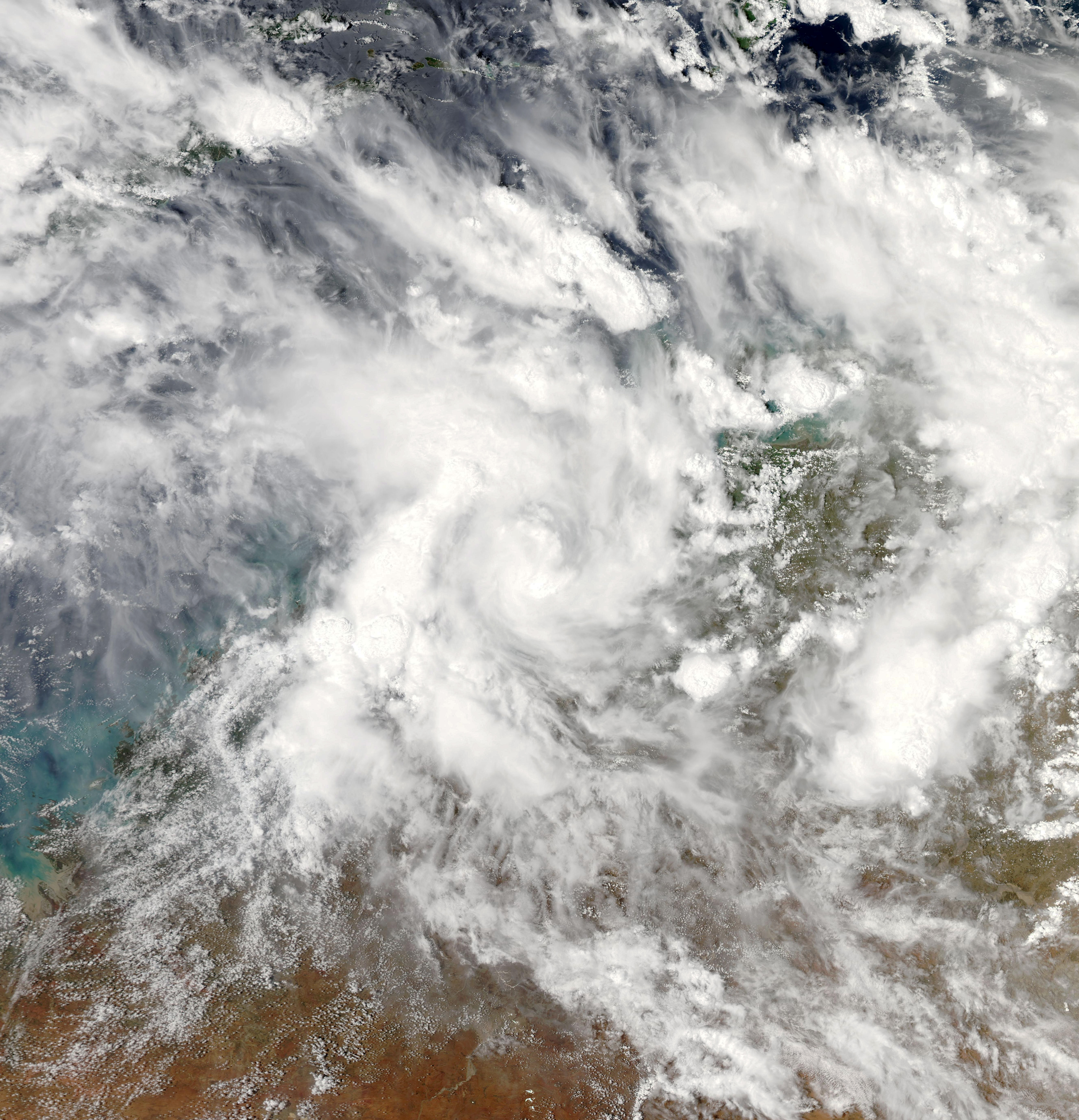
Tropical Cyclone Alessia was the first tropical cyclone to affect the Northern Territory of Australia in November since Cyclone Joan in 1975. The storm was first identified as a tropical low on 20 November 2013 well to the northwest of Australia. Tracking generally west to west-southwest, the small system steadily organized into a tropical cyclone by 22 November. Maintaining a small central dense overcast, Alessia brushed the Kimberley (Western Australia), Kimberley region before making landfall in the Top End region with winds of on 23 and 24 November respectively. Some weakening took place as the system moved over land; however, reorganization occurred as it neared the Gulf of Carpentaria. After moving over water on 26 November, it redeveloped gale-force winds. Alessia reached its peak intensity on 27 November with winds of and a barometric pressure of 991 Bar (unit), mbar (Pascal (unit), hPa; 29.26 Inches of Mercury, inHg) and subsequently m ... [...More Info...] [...Related Items...] OR: [Wikipedia] [Google] [Baidu] |
Gulf Of Carpentaria
The Gulf of Carpentaria (, ) is a large, shallow sea enclosed on three sides by northern Australia and bounded on the north by the eastern Arafura Sea (the body of water that lies between Australia and New Guinea). The northern boundary is generally defined as a line from Slade Point, Queensland (the northwestern corner of Cape York Peninsula) in the northeast, to Cape Arnhem on the Gove Peninsula, Northern Territory (the easternmost point of Arnhem Land) in the west. At its mouth, the Gulf is wide, and further south, . The north-south length exceeds . It covers a water area of about . The general depth is between and does not exceed . The tidal range in the Gulf of Carpentaria is between . The Gulf and adjacent Sahul Shelf were dry land at the peak of the last ice age 18,000 years ago when global sea level was around below its present position. At that time a large, shallow lake occupied the centre of what is now the Gulf. The Gulf hosts a submerged coral reef provinc ... [...More Info...] [...Related Items...] OR: [Wikipedia] [Google] [Baidu] |
Centre Island, Australia
Centre Island is a small, uninhabited island in the Sir Edward Pellew Group of Islands in the Gulf of Carpentaria within the Northern Territory of Australia. An automated weather station run by the Bureau of Meteorology The Bureau of Meteorology (BOM or BoM) is an executive agency of the Australian Government responsible for providing weather services to Australia and surrounding areas. It was established in 1906 under the Meteorology Act, and brought together ... has been operating on the island since 1968. Temperatures range from 23.8 °C to 31.2 °C and the average annual rainfall is 1053.4 mm. References Islands of the Northern Territory Gulf of Carpentaria Uninhabited islands of Australia {{NorthernTerritory-geo-stub ... [...More Info...] [...Related Items...] OR: [Wikipedia] [Google] [Baidu] |
Joint Typhoon Warning Center
The Joint typhoon Warning Center (JTWC) is a joint United States Navy – United States Air Force command in Pearl Harbor, Hawaii. The JTWC is responsible for the issuing of tropical cyclone warnings in the North-West Pacific Ocean, South Pacific Ocean, and Indian Ocean for all branches of the U.S. Department of Defense and other U.S. government agencies. Their warnings are intended for the protection of primarily military ships and aircraft as well as military installations jointly operated with other countries around the world. Its U.S. Navy components are aligned with the Naval Meteorology and Oceanography Command. History The origins of the Joint Typhoon Warning Center (JTWC) can be traced back to June 1945, when the Fleet Weather Center/Typhoon Tracking Center was established on the island of Guam, after multiple typhoons, including Typhoon Cobra of December 1944 and Typhoon Connie in June 1945, had caused a significant loss of men and ships. At this time the center ... [...More Info...] [...Related Items...] OR: [Wikipedia] [Google] [Baidu] |
Area Of Responsibility
Area of responsibility (AOR) is a pre-defined geographic region assigned to Combatant commanders of the Unified Command Plan (UCP), that are used to define an area with specific geographic boundaries where they have the authority to plan and conduct operations; for which a force, or component commander bears a certain responsibility. The term may also be used in other countries worldwide but it originated within the United States Armed Forces. This system is designed to allow a single commander to exercise command and control of all military forces in the AOR, regardless of their branch of service. The President of the United States signed the U.S. Unified Command Plan (UCP) 2008 on 17 December 2008, establishing the up-to-date boundaries for the newest Command, United States Africa Command (USAFRICOM), and all changes to boundaries of the other Commands.DefenseLINK-Unified Command Plan"The World with Commanders' Area of Responsibility". Retrieved 29 December 2009. U.S Unified Co ... [...More Info...] [...Related Items...] OR: [Wikipedia] [Google] [Baidu] |
Bureau Of Meteorology (Australia)
The Bureau of Meteorology (BOM or BoM) is an executive agency of the Australian Government responsible for providing weather services to Australia and surrounding areas. It was established in 1906 under the Meteorology Act, and brought together the state meteorological services that existed before then. The states officially transferred their weather recording responsibilities to the Bureau of Meteorology on 1 January 1908. History The Bureau of Meteorology was established on 1 January 1908 following the passage of the ''Meteorology Act 1906''. Prior to Federation in 1901, each colony had had its own meteorological service, with all but two colonies also having a subsection devoted to astronomy. In August 1905, federal home affairs minister Littleton Groom surveyed state governments for their willingness to cede control, finding South Australia and Victoria unwilling. However, at a ministerial conference in April 1906 the state governments agreed to transfer responsibility for m ... [...More Info...] [...Related Items...] OR: [Wikipedia] [Google] [Baidu] |
Westerlies
The westerlies, anti-trades, or prevailing westerlies, are prevailing winds from the west toward the east in the middle latitudes between 30 and 60 degrees latitude. They originate from the high-pressure areas in the horse latitudes and trend towards the poles and steer extratropical cyclones in this general manner. Tropical cyclones which cross the subtropical ridge axis into the westerlies recurve due to the increased westerly flow. The winds are predominantly from the southwest in the Northern Hemisphere and from the northwest in the Southern Hemisphere. The westerlies are strongest in the winter hemisphere and times when the pressure is lower over the poles, while they are weakest in the summer hemisphere and when pressures are higher over the poles. The westerlies are particularly strong, especially in the Southern Hemisphere (called also 'Brave West winds' at striking Chile, Tasmania and New Zealand), in areas where land is absent, because land amplifies the flow pattern, ... [...More Info...] [...Related Items...] OR: [Wikipedia] [Google] [Baidu] |
Outflow (meteorology)
Outflow, in meteorology, is air that flows outwards from a storm system. It is associated with ridging, or anticyclonic flow. In the low levels of the troposphere, outflow radiates from thunderstorms in the form of a wedge of rain-cooled air, which is visible as a thin rope-like cloud on weather satellite imagery or a fine line on weather radar imagery. For observers on the ground, a thunderstorm outflow boundary often approaches in otherwise clear skies as a low, thick cloud that brings with it a gust front. Low-level outflow boundaries can disrupt the center of small tropical cyclones. However, outflow aloft is essential for the strengthening of a tropical cyclone. If this outflow is restricted or undercut, the tropical cyclone weakens. If two tropical cyclones are in close proximity, the upper-level outflow from the upwind system can limit the development of the other system. Thunderstorms For thunderstorms, outflow tends to indicate the development of a system. Large quan ... [...More Info...] [...Related Items...] OR: [Wikipedia] [Google] [Baidu] |
Sea Surface Temperatures
Sea surface temperature (SST), or ocean surface temperature, is the ocean temperature close to the surface. The exact meaning of ''surface'' varies according to the measurement method used, but it is between and below the sea surface. Air masses in the Earth's atmosphere are highly modified by sea surface temperatures within a short distance of the shore. Localized areas of heavy snow can form in bands downwind of warm water bodies within an otherwise cold air mass. Warm sea surface temperatures are known to be a cause of tropical cyclogenesis over the Earth's oceans. Tropical cyclones can also cause a cool wake, due to turbulent mixing of the upper of the ocean. SST changes diurnally, like the air above it, but to a lesser degree. There is less SST variation on breezy days than on calm days. In addition, ocean currents such as the Atlantic Multidecadal Oscillation (AMO), can affect SST's on multi-decadal time scales, a major impact results from the global thermohaline cir ... [...More Info...] [...Related Items...] OR: [Wikipedia] [Google] [Baidu] |
Wind Shear
Wind shear (or windshear), sometimes referred to as wind gradient, is a difference in wind speed and/or direction over a relatively short distance in the atmosphere. Atmospheric wind shear is normally described as either vertical or horizontal wind shear. Vertical wind shear is a change in wind speed or direction with a change in altitude. Horizontal wind shear is a change in wind speed with a change in lateral position for a given altitude. Wind shear is a microscale meteorological phenomenon occurring over a very small distance, but it can be associated with mesoscale or synoptic scale weather features such as squall lines and cold fronts. It is commonly observed near microbursts and downbursts caused by thunderstorms, fronts, areas of locally higher low-level winds referred to as low-level jets, near mountains, radiation inversions that occur due to clear skies and calm winds, buildings, wind turbines, and sailboats. Wind shear has significant effects on the control of a ... [...More Info...] [...Related Items...] OR: [Wikipedia] [Google] [Baidu] |
Tropical Cyclogenesis
Tropical cyclogenesis is the development and strengthening of a tropical cyclone in the atmosphere. The mechanisms through which tropical cyclogenesis occurs are distinctly different from those through which temperate cyclogenesis occurs. Tropical cyclogenesis involves the development of a warm-core cyclone, due to significant convection in a favorable atmospheric environment. Tropical cyclogenesis requires six main factors: sufficiently warm sea surface temperatures (at least ), atmospheric instability, high humidity in the lower to middle levels of the troposphere, enough Coriolis force to develop a low-pressure center, a pre-existing low-level focus or disturbance, and low vertical wind shear. Tropical cyclones tend to develop during the summer, but have been noted in nearly every month in most basins. Climate cycles such as ENSO and the Madden–Julian oscillation modulate the timing and frequency of tropical cyclone development. There is a limit on tropical cyclone i ... [...More Info...] [...Related Items...] OR: [Wikipedia] [Google] [Baidu] |
Rainband
A rainband is a cloud and precipitation structure associated with an area of rainfall which is significantly elongated. Rainbands can be stratiform or convective, and are generated by differences in temperature. When noted on weather radar imagery, this precipitation elongation is referred to as banded structure. Rainbands within tropical cyclones are curved in orientation. Rainbands of tropical cyclones contain showers and thunderstorms that, together with the eyewall and the eye, constitute a hurricane or tropical storm. The extent of rainbands around a tropical cyclone can help determine the cyclone's intensity. Rainbands spawned near and ahead of cold fronts can be squall lines which are able to produce tornadoes. Rainbands associated with cold fronts can be warped by mountain barriers perpendicular to the front's orientation due to the formation of a low-level barrier jet. Bands of thunderstorms can form with sea breeze and land breeze boundaries, if enough moisture ... [...More Info...] [...Related Items...] OR: [Wikipedia] [Google] [Baidu] |
RAAF Learmonth
RAAF Base Learmonth, also known as Learmonth Airport , is a joint use Royal Australian Air Force base and civil airport. It is located near the town of Exmouth on the north-west coast of Western Australia. RAAF Base Learmonth is one of the RAAF's three bare bases. No RAAF units are currently based at Learmonth and it is maintained by a small caretaker staff during peacetime. The RAAF also operates the Learmonth Air Weapons Range which covers about and is located south-west of the airbase. History During World War II a little-known landing field was constructed on the western shore of Exmouth Gulf. It was code-named "Potshot" and maintained by No. 76 Operational Base Unit, in support of Operation Potshot. In the 1950s the landing field was further developed as a military base and named RAAF Learmonth in honour of Wing Commander Charles Learmonth DFC and Bar, who, while leading No. 14 Squadron, was killed in a flying accident off Rottnest Island, Western Australia on 6 Janu ... [...More Info...] [...Related Items...] OR: [Wikipedia] [Google] [Baidu] |


