|
Crane Island (Washington)
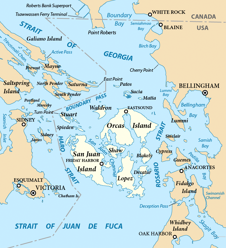
Crane Island is one of the San Juan Islands in San Juan County, Washington, United States. It lies just off the southwestern shore of Orcas Island, between it and the northwest corner of Shaw Island. Crane Island has a land area of 0.956 km² (0.369 sq mi, or 236.27 acres). The 2000 census reported a population of 20 permanent residents. many of the original full-time residents of Crane Island have moved off the island and have been replaced by younger, part-time residents. The number of permanent residents on Crane Island may be as few as four persons. Crane Island is the largest of a group of islands known as the Wasp Islands. The name was given by Charles Wilkes during the Wilkes Expedition of 1838-1842, in honor of the sloop Wasp, a sloop-of-war commanded by Jacob Jones during the War of 1812. The Wasp Islands are often locally called "the rock pile" due to the large number of rocks near the shorelines of the various islands. The Washington State ferry passes south ... [...More Info...] [...Related Items...] OR: [Wikipedia] [Google] [Baidu] |
San Juan Islands
The San Juan Islands are an archipelago in the Pacific Northwest of the United States between the U.S. state of Washington and Vancouver Island, British Columbia, Canada. The San Juan Islands are part of Washington state, and form the core of San Juan County. In the archipelago, four islands are accessible to vehicular and foot traffic via the Washington State Ferries system.San Juan Islands Route Map , Washington State Ferries 
History [...More Info...] [...Related Items...] OR: [Wikipedia] [Google] [Baidu] |
San Juan County, Washington
San Juan County is a county located in the Salish Sea in the far northwestern corner of the U.S. state of Washington. As of the 2020 census, its population was 17,788. The county seat and only incorporated city is Friday Harbor, located on San Juan Island. The county was formed on October 31, 1873, from Whatcom County and is named for the San Juan Islands, which are in turn named for Juan Vicente de Güemes, 2nd Count of Revillagigedo, the Viceroy of New Spain. Although the islands themselves have no state highways, the ferry routes serving the islands are designated as part of the state highway system. History The San Juan Islands were the subject of a territorial dispute between Great Britain and the United States from 1846 to 1872, leading to the Pig War in 1859. The bloodless conflict ended through arbitration led by Kaiser Wilhelm I, which awarded the islands to the United States. San Juan County was home to Henry Cayou, one of the first elected officials of Native ... [...More Info...] [...Related Items...] OR: [Wikipedia] [Google] [Baidu] |
Orcas Island
Orcas Island () is the largest of the San Juan Islands of the Pacific Northwest, which are in the northwestern corner of San Juan County, Washington. History and naming of the island The name "Orcas" is a shortened form of ''Horcasitas,'' from Juan Vicente de Güemes Padilla Horcasitas y Aguayo, 2nd Count of Revillagigedo, the Viceroy of New Spain who sent an exploration expedition under Francisco de Eliza to the Pacific Northwest in 1791. During the voyage, Eliza explored part of the San Juan Islands. He did not apply the name Orcas specifically to Orcas Island, but rather to part of the archipelago. In 1847, Henry Kellett assigned the name to Orcas Island during his reorganization of the British Admiralty charts. Kellett's work eliminated the patriotically American names that Charles Wilkes had given to many features of the San Juans during the Wilkes Expedition of 1838–1842. Wilkes had named Orcas Island "Hull Island" after Commodore Isaac Hull. Other features of Orcas Is ... [...More Info...] [...Related Items...] OR: [Wikipedia] [Google] [Baidu] |
Shaw Island
Shaw Island is the smallest of the four San Juan Islands served by the Washington State Ferries. The island has a land area of and a small year-round population of 240 ( 2010 census). During the summer time, weekends swell with other residents and the occasional tourist. The island is within the historical territory of the Lummi Nation. The United States obtained Shaw Island and the rest of the San Juan archipelago by treaty in 1855, but Lummi retained certain cultural and resource rights, including fishing. The Wilkes Expedition, in 1841, named the island after John Shaw, a United States Naval Officer. According to Bill Tsilixw James, hereditary chief of the Lummi Nation, the Lummi know the island as Sq'emenen. A San Juan Island resident proposed to the state Board of Geographic Names in 2015 that Squaw Bay be renamed Sq'emenen Bay; that proposal generated a compromise proposal from the Shaw Island Historical Society to rename the bay Reef Net Bay, in recognition of th ... [...More Info...] [...Related Items...] OR: [Wikipedia] [Google] [Baidu] |
Acre
The acre is a unit of land area used in the imperial Imperial is that which relates to an empire, emperor, or imperialism. Imperial or The Imperial may also refer to: Places United States * Imperial, California * Imperial, Missouri * Imperial, Nebraska * Imperial, Pennsylvania * Imperial, Texa ... and United States customary units#Units of area, US customary systems. It is traditionally defined as the area of one Chain (unit), chain by one furlong (66 by 660 feet), which is exactly equal to 10 square chains, of a square mile, 4,840 square yards, or 43,560 square feet, and approximately 4,047 m2, or about 40% of a hectare. Based upon the International yard and pound, international yard and pound agreement of 1959, an acre may be declared as exactly 4,046.8564224 square metres. The acre is sometimes abbreviated ac but is usually spelled out as the word "acre".National Institute of Standards and Technolog(n.d.) General Tables of Units of Measurement . Traditionally, i ... [...More Info...] [...Related Items...] OR: [Wikipedia] [Google] [Baidu] |
United States Census, 2000
The United States census of 2000, conducted by the Census Bureau, determined the resident population of the United States on April 1, 2000, to be 281,421,906, an increase of 13.2 percent over the 248,709,873 people enumerated during the 1990 census. This was the twenty-second federal census and was at the time the largest civilly administered peacetime effort in the United States. Approximately 16 percent of households received a "long form" of the 2000 census, which contained over 100 questions. Full documentation on the 2000 census, including census forms and a procedural history, is available from the Integrated Public Use Microdata Series. This was the first census in which a state – California – recorded a population of over 30 million, as well as the first in which two states – California and Texas – recorded populations of more than 20 million. Data availability Microdata from the 2000 census is freely available through the Integrated Public Use Microdata Serie ... [...More Info...] [...Related Items...] OR: [Wikipedia] [Google] [Baidu] |
Charles Wilkes
Charles Wilkes (April 3, 1798 – February 8, 1877) was an American naval officer, ship's captain, and explorer. He led the United States Exploring Expedition (1838–1842). During the American Civil War (1861–1865), he commanded ' during the Trent Affair in which he stopped a Royal Mail ship and removed two Confederate diplomats, which almost led to war between the United States and the United Kingdom. Early life and career Wilkes was born in New York City, on April 3, 1798, as the great nephew of the former Lord Mayor of London John Wilkes. His mother was Mary Seton, who died in 1802 when Charles was just three years old. As a result, Charles was raised by his aunt, Elizabeth Ann Seton, who would later convert to Roman Catholicism and become the first American-born woman canonized a saint by the Catholic Church. When Elizabeth was left widowed with five children, Charles was sent to a boarding school, and later attended Columbia College, which is the present-day Columbia Uni ... [...More Info...] [...Related Items...] OR: [Wikipedia] [Google] [Baidu] |
Wilkes Expedition
The United States Exploring Expedition of 1838–1842 was an exploring and surveying expedition of the Pacific Ocean and surrounding lands conducted by the United States. The original appointed commanding officer was Commodore Thomas ap Catesby Jones. Funding for the original expedition was requested by President John Quincy Adams in 1828; however, Congress would not implement funding until eight years later. In May 1836, the oceanic exploration voyage was finally authorized by Congress and created by President Andrew Jackson. The expedition is sometimes called the U.S. Ex. Ex. for short, or the Wilkes Expedition in honor of its next appointed commanding officer, United States Navy Lieutenant Charles Wilkes. The expedition was of major importance to the growth of science in the United States, in particular the then-young field of oceanography. During the event, armed conflict between Pacific islanders and the expedition was common and dozens of natives were killed in action, ... [...More Info...] [...Related Items...] OR: [Wikipedia] [Google] [Baidu] |
Sloop-of-war
In the 18th century and most of the 19th, a sloop-of-war in the Royal Navy was a warship with a single gun deck that carried up to eighteen guns. The rating system covered all vessels with 20 guns and above; thus, the term ''sloop-of-war'' encompassed all the unrated combat vessels, including the very small gun-brigs and cutters. In technical terms, even the more specialised bomb vessels and fireships were classed as sloops-of-war, and in practice these were employed in the sloop role when not carrying out their specialised functions. In World War I and World War II, the Royal Navy reused the term "sloop" for specialised convoy-defence vessels, including the of World War I and the highly successful of World War II, with anti-aircraft and anti-submarine capability. They performed similar duties to the American destroyer escort class ships, and also performed similar duties to the smaller corvettes of the Royal Navy. Rigging A sloop-of-war was quite different from a civilian ... [...More Info...] [...Related Items...] OR: [Wikipedia] [Google] [Baidu] |
Wasp Islands
The Wasp Islands are a group of small islands in the San Juan Islands of the U.S. state of Washington. The name was given by Charles Wilkes during the Wilkes Expedition of 1838–1842, in honor of the sloop ''Wasp'', a sloop of war commanded by Johnathan Blakeley during the War of 1812 The War of 1812 (18 June 1812 – 17 February 1815) was fought by the United States of America and its indigenous allies against the United Kingdom and its allies in British North America, with limited participation by Spain in Florida. It bega .... References External links * San Juan Islands {{SanJuanCountyWA-geo-stub ... [...More Info...] [...Related Items...] OR: [Wikipedia] [Google] [Baidu] |
Pig War (1859)
The Pig War was a confrontation in 1859 between the United States and the United Kingdom of Great Britain and Ireland, United Kingdom over the Canada–United States border, British–U.S. border in the San Juan Islands, between Vancouver Island (present-day Canada) and the Washington (state), State of Washington. The Pig War, so called because it was triggered by the shooting of a domestic pig, pig, is also called the Pig Episode, the Pig and Potato War, the San Juan Boundary Dispute, and the Northwestern Boundary Dispute. Despite being referred to as a "war" there were no casualties on either side, aside from the pig. Background Border ambiguity The Oregon Treaty of June 15, 1846, resolved the Oregon boundary dispute by dividing the Oregon Country/Columbia District between the United States and Britain "along the 49th parallel north, forty-ninth parallel of north latitude to the middle of the channel which separates the continent from Vancouver Island, and thence southerly ... [...More Info...] [...Related Items...] OR: [Wikipedia] [Google] [Baidu] |


.jpg)

