|
Covert Sites Of The Laotian Civil War
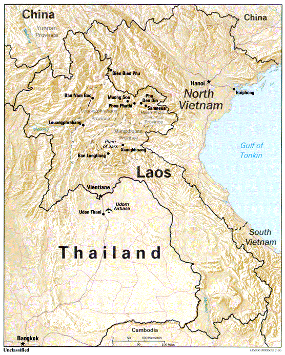
Covert sites of the Laotian Civil War were clandestine U.S. military installations for conducting covert paramilitary and combat operations in the Kingdom of Laos. Airstrips within the Kingdom of Laos were originally designated by Air America as "Site XX" (with XX being a number). In September 1961, the designation changed to "VS XX", meaning "Victor Site XX". On 16 May 1964, the airstrips received their final designation; the site names then used the abbreviation "LS"—Lima Site—for unimproved strips, or "L"—Lima—for paved runways. The terms "Victor" and "Lima" were taken from the existing military phonetic code. These sites typically were centered on a dirt landing strip for STOL aircraft such as the Air America Helio Courier or Pilatus Porter. These strips were often carved out along ridge lines, and were seldom flat, straight, or of sufficient length. However, they were crucial for resupply and personnel transport, including medical evacuations. To quote one source: "Som ... [...More Info...] [...Related Items...] OR: [Wikipedia] [Google] [Baidu] |
Kingdom Of Laos
The Kingdom of Laos was a landlocked country in Southeast Asia at the heart of the Indochinese Peninsula. It was bordered by Burma and China to the northwest, North Vietnam to the east, Cambodia to the southeast, and Thailand to the west and southwest. The country was governed as a constitutional monarchy that ruled Laos beginning with its independence on 9 November 1953. It survived until December 1975, when its last king, Sisavang Vatthana, surrendered the throne to the Pathet Lao during the civil war in Laos, who abolished the monarchy in favour of a Marxist–Leninist state called the Lao People's Democratic Republic, which has controlled Laos ever since. Given self-rule with the new Constitution in 1947 as part of the French Union and a federation with the rest of French Indochina, the 1953 Franco-Lao Treaty finally established a sovereign, independent Laos, but did not stipulate who would rule the country. In the years that followed, three groups led by the so-call ... [...More Info...] [...Related Items...] OR: [Wikipedia] [Google] [Baidu] |
Lima Site 36
Lima Site 36 (also known as LS-36) was an Air America and U.S. Air Force facility built in the village of Na Khang, near the Plain of Jars in Laos, during the Vietnam War. It was the scene of several clashes in 1966, 1967 and 1968 and was finally captured by the People's Army of Vietnam forces in 1969. History From 1965 LS-36 was used as a forward base for U.S. Air Force combat search and rescue helicopters of the 38th Air Rescue Squadron. Two squadron helicopters would deploy at dawn from Udorn Royal Thai Air Force Base to LS-36 and the crews would then pass the time awaiting distress calls from aircraft on missions over Laos or North Vietnam. At the end of the day the helicopters would return to Udorn. After overrunning Lima Site 27 on the night of 12 February 1966, on the early morning of 17 February 1966, Pathet Lao and People's Army of Vietnam (PAVN) forces attacked LS-36. The attackers had a strength of 600–1000 men and included elements of the PAVN 5th Battalion, ... [...More Info...] [...Related Items...] OR: [Wikipedia] [Google] [Baidu] |
North Vietnamese Invasion Of Laos
North Vietnam supported the Pathet Lao to fight against the Kingdom of Laos between 1958–1959. Control over Laos allowed for the eventual construction of the Ho Chi Minh Trail that would serve as the main supply route for enhanced NLF (the National Liberation Front, the Vietcong) and NVA (North Vietnamese Army) activities in the Republic of Vietnam. As such, the support for Pathet Lao to fight against Kingdom of Laos by North Vietnam would prove decisive in the eventual communist victory over South Vietnam in 1975 as the South Vietnamese and American forces could have prevented any NVA and NLF deployment and resupply if these only happened over the 17th Parallel, also known as the Demilitarized Zone (DMZ), a narrow strip of land between North and South Vietnam that was closely guarded by both sides. It also helped the Pathet Lao win against the Kingdom of Laos, even though the Kingdom of Laos had American support. Prelude to conflict Souvanna Phouma announced that, with t ... [...More Info...] [...Related Items...] OR: [Wikipedia] [Google] [Baidu] |
Laotian Civil War
The Laotian Civil War (1959–1975) was a civil war in Laos which was waged between the Communist Pathet Lao and the Royal Lao Government from 23 May 1959 to 2 December 1975. It is associated with the Cambodian Civil War and the Vietnam War, with both sides receiving heavy external support in a proxy war between the global Cold War superpowers. It is called the Secret War among the American CIA Special Activities Center, and Hmong and Mien veterans of the conflict. The Kingdom of Laos was a covert theater for other belligerents during the Vietnam War. The Franco–Lao Treaty of Amity and Association (signed 22 October 1953) transferred remaining French powers to the Royal Lao Government (except control of military affairs), establishing Laos as an independent member of the French Union. However, this government did not include representatives from the Lao Issara anti-colonial armed nationalist movement. The following years were marked by a rivalry between the neutralists ... [...More Info...] [...Related Items...] OR: [Wikipedia] [Google] [Baidu] |
Xiangkhouang
Xiangkhouang (Lao alphabet, Lao: wikt:ຊຽງຂວາງ, ຊຽງຂວາງ, meaning 'Horizontal City') is a province of Laos on the Xiangkhoang Plateau, in the nation's northeast. The province has the distinction of being the most heavily bombed place on Earth. The province was originally known as the Principality of ''Muang Phuan'' (Muang Phouan / Xieng Khouang). Its present capital is Phonsavan. The population of the province as of the 2015 census was 244,684. Xiangkhouang province covers an area of and is mountainous. Apart from floodplains, the largest area of level land in the country is on the province's Xiangkhoang Plateau. The plateau is characterized by rolling hills and grassland whose elevation averages . The country's highest peak, Phou Bia (), rises at the south side of the plateau. Nam Et-Phou Louey is a National Biodiversity Conservation Area (NBCA) in the province, covering an area of 5,959 km2, and overlaps into Houaphanh province, Houaphanh and L ... [...More Info...] [...Related Items...] OR: [Wikipedia] [Google] [Baidu] |
Ban Xong-Na Xu
Ban, or BAN, may refer to: Law * Ban (law), a decree that prohibits something, sometimes a form of censorship, being denied from entering or using the place/item ** Imperial ban (''Reichsacht''), a form of outlawry in the medieval Holy Roman Empire * Ban (medieval), the sovereign's power to command ** King's ban (''Königsbann''), a royal command or prohibition in the medieval Holy Roman Empire * Herem (other), a Hebrew word usually translated as "the ban" * A ban could be served on people in apartheid-era South Africa People * Ban (surname), a Chinese surname * Ban (Korean name), a Korean surname and element in given names ** Ban Ki-moon, United Nations Secretary-General * King Ban, a king from the Matter of Britain * Ban (title), a noble title used in Central and Southeastern Europe (Romania, Croatia, Bosnia and Hungary) ** Banate of Bosnia ** Ban of Croatia * Matija Ban, a Croatian poet * Oana Ban, a Romanian artistic gymnast * Shigeru Ban, a Japanese archi ... [...More Info...] [...Related Items...] OR: [Wikipedia] [Google] [Baidu] |
Ban Houei Sane
The Battle of Ban Houei Sane was a battle of the Vietnam War that began on the night of 23 January 1968, when the 24th Regiment of the People's Army of Vietnam (PAVN) 304th Division overran the small Royal Lao Army outpost at Ban Houei Sane. The fighting at Ban Houei Sane was one in a series of battles fought between North Vietnamese and Allied forces during the Tet Offensive. The small outpost, defended by the 700 man Bataillon Volontaire (BV-33), was attacked and overwhelmed by the vastly superior PAVN and their PT-76 light tanks. The failure of BV-33 to defend their outpost at Ban Houei Sane had negative consequences only a few weeks later, when the PAVN struck again at Lang Vei. Background During the First Indochina War the Viet Minh constructed a pathway in neighbouring Laos in order to transport vital military supplies to southern Vietnam. Over time that pathway, now known as the Ho Chi Minh Trail, grew in importance as the government of the Democratic Republic of Vietnam ... [...More Info...] [...Related Items...] OR: [Wikipedia] [Google] [Baidu] |
Muang Soui
Muang Soui(In Lao: ເມືອງສຸຍ) (also called Muang Souy or Muong Soui) is a small town in Xiangkhouang Province Laos. It is located on Route 7 of Laos, so east of Phoukhoune district, northwest of Phonsavan, and Ban Phou Pheung Noi, but north of Sam Thong, and Long Tieng. History Muang Soui (in Lao:''ເມືອງ ສຸຍ'') or Muang Souy was a small town which was located in the Xiangkhouang Province, Laos. Its population was around 10,000 in 1965. It was a small town among many like the cities of Phonsavan, Plain of Jars, Lathuang, Nong Het, Long Tieng, Sam Thong and many others. These towns were all located in Xiangkhouang Province. They were all well known during and before the Vietnam War 1961–1975. Muang Soui was created shortly before 1960 when Captain Kong Le overthrew the Royal Lao Government in a coup, 1960 Laotian coups, on August 10, 1960. Before this town was created and called Muang Soui, the old name of that town was ''Ban NongTang'' (in lao ... [...More Info...] [...Related Items...] OR: [Wikipedia] [Google] [Baidu] |
Battle Of Lima Site 85
The Battle of Lima Site 85, also called Battle of Phou Pha Thi, was fought as part of a military campaign waged during the Vietnam War and Laotian Civil War by the North Vietnamese People's Army of Vietnam (PAVN) and the Pathet Lao, against airmen of the United States Air Force (USAF)'s 1st Combat Evaluation Group, elements of the Royal Lao Army, Royal Thai Border Patrol Police, and the Central Intelligence Agency-led Hmong Clandestine Army. The battle was fought on Phou Pha Thi mountain in Houaphanh Province, Laos, on 10 March 1968, and derives its name from the mountaintop where it was fought or from the designation of a landing strip in the valley below, and was the largest single ground combat loss of United States Air Force members during the Vietnam War. During the Vietnam War and the Laotian Civil War, Phou Pha Thi mountain was an important strategic outpost which had served both sides at various stages of the conflict. In 1966, the United States Ambassador ... [...More Info...] [...Related Items...] OR: [Wikipedia] [Google] [Baidu] |
Phou Pha Thi
Phou Pha Thi (Phathi) is a "sacred mountain" in Laos "believed...inhabited by great "phi", or spirits and used for the clandestine Lima Site 85 military installation during the Vietnam War. The lightly defended installation was destroyed by North Vietnamese attackers in the 10-11 March 1968 Battle of Lima Site 85. From 1994 to 2004, searches for USAF remains were conducted at the mountain, but few bodies were located. The mountain is "100 miles south of Dien Bien Phu, 160 miles west of Hanoi, and just 25 miles from the capital of Samneua Xam Neua (ຊຳເໜືອ , sometimes transcribed as ''Sam Neua'' or ''Samneua'', literally 'northern swamp'), is the capital of Houaphanh Province, Laos, in northeast Laos. Demographics Residents are mostly Lao, Vietnamese, and Hmong, with so ...". The site had been used as a military site by French colonialists until seized by the North Vietnamese in 1962, and the Hmong "Secret Army" recaptured the area and a Central Intelligence Agency a ... [...More Info...] [...Related Items...] OR: [Wikipedia] [Google] [Baidu] |
Lima Site 85
Lima Site 85 (LS-85 alphanumeric code of the phonetic 1st letter used to conceal this covert operation) was a clandestine military installation in the Royal Kingdom of Laos guarded by the Hmong "Secret Army", the Central Intelligence Agency, and the United States Air Force used for Vietnam War covert operations against communist targets in ostensibly neutral Laos under attack by the Vietnam People's Army. Initially created for a CIA command post to support a local stronghold, the site was expanded with a 1966 TACAN area excavated on the mountaintop where a 1967 command guidance radar was added for Commando Club bombing of northern areas of North Vietnam. The site ended operations with the Battle of Lima Site 85 when most of the U.S. technicians on the mountaintop were killed, including CMSgt Richard Etchberger. For his heroism and sacrifice, Etchberger received the Air Force Cross posthumously. The operation remained classified, however, and the existence of the award was no ... [...More Info...] [...Related Items...] OR: [Wikipedia] [Google] [Baidu] |
Muang Phalan TACAN Site
Muang Phalan TACAN Site (also known as Lima Site 61 or LS 61) was a U.S. Air Force facility built in the village of Muang Phalan, Laos, during the Vietnam War. History Muang Phalan TACAN Site was established by the U.S. Air Force in April 1967 as part of Operation Bright Light to create a network of TACAN sites to support air operations over southern Laos and Vietnam. The site operated as TACAN Channel 77. On 25 December 1967 the site was attacked by the People's Army of Vietnam who overran the facility killing the two "sheep-dipped" technicians from the 1st Mobile Communications Group. A replacement TACAN site was installed at Mukdahan, Thailand. Current use The site is abandoned and turned over to farmland and housing. See also *Lima Site 85 Lima Site 85 (LS-85 alphanumeric code of the phonetic 1st letter used to conceal this covert operation) was a clandestine military installation in the Royal Kingdom of Laos guarded by the Hmong "Secret Army", the Central Intelli ... [...More Info...] [...Related Items...] OR: [Wikipedia] [Google] [Baidu] |


