|
Cooke's Range
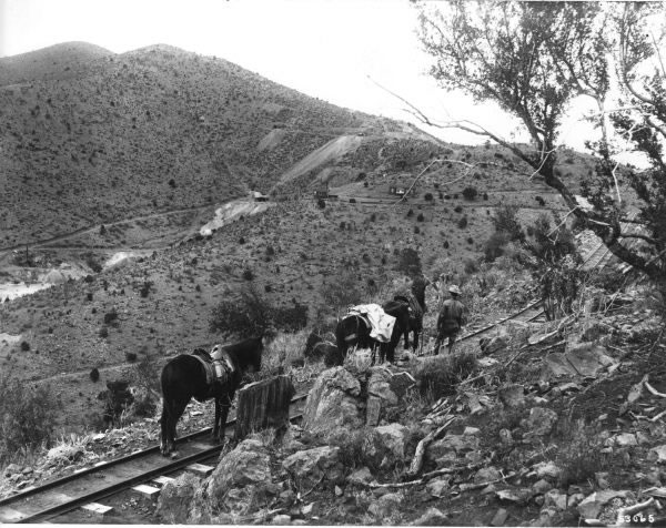
The Cookes Range (Cooke's Range, Cooks Range or Cook's Range) is a small, 17-mi (27 km) long mountain range in northern Luna County, New Mexico, which extends slightly north into southeastern Grant County. The range is a southern continuation of the Mimbres Mountains, itself the southeast portion of the extensive north–south running Black Range. The Cookes Range is surrounded by lower elevation areas of the northwest Chihuahuan Desert. Description Cookes Range is about 17 mi long, and about 8 mi at its widest. The range is a basin and range north-south trending uplift with a center-north section intruded by granodiorite which forms Cookes Peak, . Cookes Peak is at the head of OK Canyon, which exits the range eastwards. South of OK Canyon is a transverse ridgeline, across the range west to east, named Rattlesnake Ridge. One other larger peak occurs in the mountains and hills in the southern part of the range, Massacre Peak, at . Other outlying lower elevation hi ... [...More Info...] [...Related Items...] OR: [Wikipedia] [Google] [Baidu] |
Chihuahuan Desert
The Chihuahuan Desert ( es, Desierto de Chihuahua, ) is a desert ecoregion designation covering parts of northern Mexico and the southwestern United States. It occupies much of far West Texas, the middle to lower Rio Grande Valley and the lower Pecos Valley in New Mexico, and a portion of southeastern Arizona, as well as the central and northern portions of the Mexican Plateau. It is bordered on the west by the Sonoran Desert, the Colorado Plateau, and the extensive Sierra Madre Occidental range, along with northwestern lowlands of the Sierra Madre Oriental range. Its largest, continual expanse is located in Mexico, covering a large portion of the state of Chihuahua, along with portions of Coahuila, north-eastern Durango, the extreme northern part of Zacatecas, and small western portions of Nuevo León. With an area of about , it is the largest desert in North America. The desert is fairly young, existing for only 8000 years. Geography There are several larger mountain ranges ... [...More Info...] [...Related Items...] OR: [Wikipedia] [Google] [Baidu] |
Grant County, New Mexico
Grant County is a county located in the U.S. state of New Mexico. At the 2020 census, the population was 28,185. Its county seat is Silver City. The county was founded in 1868 and named for Ulysses S. Grant, the 18th President of the United States. Grant County comprises the Silver City, NM, Micropolitan Statistical Area. It is part of the Southwest New Mexico Council of Governments. Geography According to the U.S. Census Bureau, the county has a total area of , of which is land and (0.1%) is water. Adjacent counties * Catron County - north * Sierra County - east * Luna County - southeast * Hidalgo County - south * Greenlee County, Arizona - west National protected area * Gila National Forest (part) Demographics 2000 census At the 2000 census, there were 31,002 people, 12,146 households and 8,514 families living in the county. The population density was . There were 14,066 housing units at an average density of . The racial make-up was 75.67% White, 0.52% Black or ... [...More Info...] [...Related Items...] OR: [Wikipedia] [Google] [Baidu] |
Mountain Ranges Of New Mexico
A mountain is an elevated portion of the Earth's crust, generally with steep sides that show significant exposed bedrock. Although definitions vary, a mountain may differ from a plateau in having a limited summit area, and is usually higher than a hill, typically rising at least 300 metres (1,000 feet) above the surrounding land. A few mountains are isolated summits, but most occur in mountain ranges. Mountains are formed through tectonic forces, erosion, or volcanism, which act on time scales of up to tens of millions of years. Once mountain building ceases, mountains are slowly leveled through the action of weathering, through slumping and other forms of mass wasting, as well as through erosion by rivers and glaciers. High elevations on mountains produce colder climates than at sea level at similar latitude. These colder climates strongly affect the ecosystems of mountains: different elevations have different plants and animals. Because of the less hospitable terrain a ... [...More Info...] [...Related Items...] OR: [Wikipedia] [Google] [Baidu] |
Battle Of Cookes Canyon
The Battle of Cookes Canyon was a military engagement fought between settlers from Confederate Arizona and Chiricahua Apaches in August 1861. It occurred about northwest of Mesilla, in Cookes Canyon. The exact date of the battle is unknown. The battle occurred in the larger context of both the Apache Wars and the American Civil War. Background In early August, a group of Arizonan refugees from the Tubac area abandoned their village after the withdrawal of U.S. troops from Fort Buchanan and the Siege of Tubac which left their homes burned. The bunch was known as the Ake Party, and their destination was the Rio Grande near Mesilla. The wagon train consisted of six double wagons, two buggies, and one single wagon when it reached Tucson from the surrounding region. At Tucson, several other people joined the procession, which including Moses Carson, the half-brother of the famous scout and soldier Kit Carson. The party was composed of 24 men, 16 women, and 7 children, along ... [...More Info...] [...Related Items...] OR: [Wikipedia] [Google] [Baidu] |
Cookes Range Wilderness Study Area , surname
{{surname ...
Cookes is a surname. Notable people with the surname include: *Thomas Cookes (MP) (1804–1900), British politician *Sir Thomas Cookes, 2nd Baronet (bap. 1648–1701), English philanthropist *Cookes baronets See also *Cooks (surname) *Cooke Cooke is a surname derived from the occupation of cook. Notable people with the surname include: * Alexander Cooke (died 1614), English actor * Alfred Tyrone Cooke, of the Indo-Pakistani wars * Alistair Cooke KBE (1908–2004), British-American j ... [...More Info...] [...Related Items...] OR: [Wikipedia] [Google] [Baidu] |
Butterfield Trail
Butterfield Overland Mail (officially the Overland Mail Company)Waterman L. Ormsby, edited by Lyle H. Wright and Josephine M. Bynum, "The Butterfield Overland Mail", The Huntington Library, San Marino, California, 1991. was a stagecoach service in the United States operating from 1858 to 1861. It carried passengers and U.S. Mail from two eastern termini, Memphis, Tennessee, and St. Louis, Missouri, to San Francisco, California. The routes from each eastern terminus met at Fort Smith, Arkansas, and then continued through Indian Territory (Oklahoma), Texas, New Mexico, Arizona, Mexico, and California ending in San Francisco.Goddard Bailey, Special Agent to Hon. A.V. Brown. P.M., Washington, D.C., The Senate of the United States, Second Session, Thirty-Fifth Congress, 1858–'59, Postmaster General, Appendix, "Great Overland Mail", Washington, D. C., October 18, 1858.https://babel.hathitrust.org/cgi/pt?id=uc1.c109481050;view=1up;seq=745 On March 3, 1857, Congress authorized the U.S. p ... [...More Info...] [...Related Items...] OR: [Wikipedia] [Google] [Baidu] |
Mormon Battalion
The Mormon Battalion was the only religious unit in United States military history in federal service, recruited solely from one religious body and having a religious title as the unit designation. The volunteers served from July 1846 to July 1847 during the Mexican–American War of 1846–1848. The battalion was a volunteer unit of between 534 and 559 Latter-day Saint men, led by Mormon company officers commanded by regular U.S. Army officers. During its service, the battalion made a grueling march of nearly 2,100 miles from Council Bluffs, Iowa, to San Diego, California. The Battalion’s march and service supported the eventual cession of much of the American Southwest from Mexico to the United States, especially the Gadsden Purchase of 1853 of southern Arizona and New Mexico. The march also opened a southern wagon route to California. Veterans of the Battalion played significant roles in America's westward expansion in California, Utah, Nevada, Arizona and other parts of ... [...More Info...] [...Related Items...] OR: [Wikipedia] [Google] [Baidu] |
Basin And Range Topography
Basin and range topography is characterized by alternating parallel mountain ranges and valleys. It is a result of crustal extension due to mantle upwelling, gravitational collapse, crustal thickening, or relaxation of confining stresses. The extension results in the thinning and deformation of the upper crust, causing it to fracture and create a series of long parallel normal faults. This results in block faulting, where the blocks of rock between the normal faults either subside, uplift, or tilt. The movement of these blocks results in the alternating valleys and mountains. As the crust thins, it also allows heat from the mantle to more easily melt rock and form magma, resulting in increased volcanic activity. Types of faulting Symmetrical faulting: horst and graben With crustal extension, a series of normal faults which occur in groups, form in close proximity and dipping in opposite directions. As the crust extends it fractures in series of fault planes, some bl ... [...More Info...] [...Related Items...] OR: [Wikipedia] [Google] [Baidu] |
Black Range
Black is a color which results from the absence or complete absorption of visible light. It is an achromatic color, without hue, like white and grey. It is often used symbolically or figuratively to represent darkness. Black and white have often been used to describe opposites such as good and evil, the Dark Ages versus Age of Enlightenment, and night versus day. Since the Middle Ages, black has been the symbolic color of solemnity and authority, and for this reason it is still commonly worn by judges and magistrates. Black was one of the first colors used by artists in Neolithic cave paintings. It was used in ancient Egypt and Greece as the color of the underworld. In the Roman Empire, it became the color of mourning, and over the centuries it was frequently associated with death, evil, witches, and magic. In the 14th century, it was worn by royalty, clergy, judges, and government officials in much of Europe. It became the color worn by English romantic poets, businessmen ... [...More Info...] [...Related Items...] OR: [Wikipedia] [Google] [Baidu] |
Mountain Range
A mountain range or hill range is a series of mountains or hills arranged in a line and connected by high ground. A mountain system or mountain belt is a group of mountain ranges with similarity in form, structure, and alignment that have arisen from the same cause, usually an orogeny. Mountain ranges are formed by a variety of geological processes, but most of the significant ones on Earth are the result of plate tectonics. Mountain ranges are also found on many planetary mass objects in the Solar System and are likely a feature of most terrestrial planets. Mountain ranges are usually segmented by highlands or mountain passes and valleys. Individual mountains within the same mountain range do not necessarily have the same geologic structure or petrology. They may be a mix of different orogenic expressions and terranes, for example thrust sheets, uplifted blocks, fold mountains, and volcanic landforms resulting in a variety of rock types. Major ranges Most geolo ... [...More Info...] [...Related Items...] OR: [Wikipedia] [Google] [Baidu] |
Luna County, New Mexico
Luna County is a county located in the U.S. state of New Mexico. As of the 2010 census, the population was 25,095. Its county seat is Deming. This county abuts the Mexican border. Luna County comprises the Deming, NM Micropolitan Statistical Area. History Luna County was formed from parts of Grant County and Doña Ana County by the New Mexico Legislature on March 16, 1901. It was named for Solomon Luna, a politician who advocated for independence of the county, following a strong rivalry between the cities of Deming and Silver City, both of which were at the time in Grant County. Before dawn on March 16, 1916, Mexican revolutionary Pancho Villa led several hundred of his rebel soldiers across the Mexican border into the southern county village of Columbus. The invaders raided and burned much of the town, causing many residents to flee to the desert. Although the raid completely surprised everyone in the town, it also awakened 350 United States Army soldiers at Camp Furlon ... [...More Info...] [...Related Items...] OR: [Wikipedia] [Google] [Baidu] |


