|
Chota Nagpur States
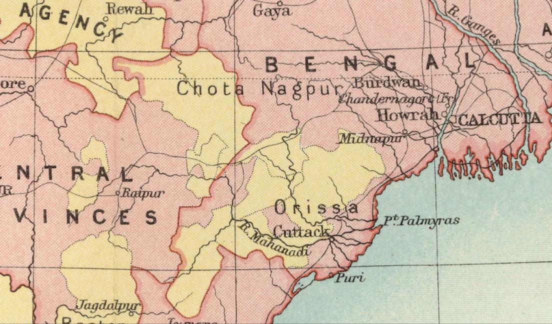
The Chota Nagpur Tributary States or Chota Nagpur States were a group of non-salute states (minor princely states) at the time of British Raj, located on the Chhota Nagpur Plateau. British suzerainty over the states was exercised through the government of the Bengal Presidency. These states were nine in number and they became part of the Indian states of Madhya Pradesh, Bihar and Odisha following Indian Independence. History In the 18th century, the states came within the sphere of influence of the Maratha Empire, but they became tributary states of British India as a result of the Anglo-Maratha Wars in the early 19th century. In October 1905, the exercise of British influence over the predominantly Hindi-speaking states of Chang Bhakar, Jashpur, Koriya, Surguja, and Udaipur was transferred from the Bengal government to that of the Central Provinces, while the two Oriya-speaking state Gangpur and Bonai were attached to the Orissa Tributary States, leaving only Kharsawan ... [...More Info...] [...Related Items...] OR: [Wikipedia] [Google] [Baidu] |
British India
The provinces of India, earlier presidencies of British India and still earlier, presidency towns, were the administrative divisions of British governance on the Indian subcontinent. Collectively, they have been called British India. In one form or another, they existed between 1612 and 1947, conventionally divided into three historical periods: *Between 1612 and 1757 the East India Company set up Factory (trading post), factories (trading posts) in several locations, mostly in coastal India, with the consent of the Mughal emperors, Maratha Empire or local rulers. Its rivals were the merchant trading companies of Portugal, Denmark, the Netherlands, and France. By the mid-18th century, three ''presidency towns'': Madras, Bombay and Calcutta, had grown in size. *During the period of Company rule in India (1757–1858), the company gradually acquired sovereignty over large parts of India, now called "presidencies". However, it also increasingly came under British government over ... [...More Info...] [...Related Items...] OR: [Wikipedia] [Google] [Baidu] |
Sphere Of Influence
In the field of international relations, a sphere of influence (SOI) is a spatial region or concept division over which a state or organization has a level of cultural, economic, military or political exclusivity. While there may be a formal alliance or other treaty obligations between the influenced and influencer, such formal arrangements are not necessary and the influence can often be more of an example of soft power. Similarly, a formal alliance does not necessarily mean that one country lies within another's sphere of influence. High levels of exclusivity have historically been associated with higher levels of conflict. In more extreme cases, a country within the "sphere of influence" of another may become a subsidiary of that state and serve in effect as a satellite state or ''de facto'' colony. This was the case with the Soviet Union and its Eastern Bloc after World War II. The system of spheres of influence by which powerful nations intervene in the affairs of others co ... [...More Info...] [...Related Items...] OR: [Wikipedia] [Google] [Baidu] |
Gangpur State
Gangpur State, also known as Gangpore State, was one of the princely states of India during the period of the British Raj. Until 1905 it was one of the Chhota Nagpur States under the Eastern States Agency. Covering an area of 6454 km2, in 1941 Gangpur had a population of 398,171. The population was predominantly Odia speaking. It was made part of India on 1 January 1948. The capital of Gangpur State was modern Sundargarh of Odisha. History According to traditions, the dynasty was established by Gangadhar Sekhar Deo, a scion of the Sekhar dynasty from Sikharbhum near the Singhbhum region of Eastern India with the help of the dominant local Bhuyan clans. Written archival records point to the reign of Indra Shekhar Deo under whom the region formally became a part of the British Empire after the defeat of the Marathas in the Second Anglo-Maratha War. Gangpur was a feudatory estate of Sambalpur. In 1821 the British authorities canceled the feudatory rights of Sambalpur ove ... [...More Info...] [...Related Items...] OR: [Wikipedia] [Google] [Baidu] |
Bonai State
Bonai State ( or, ବଣାଇ), was a princely state during the British Raj in what is today India. It was one of the Chota Nagpur States and had its capital at Bonaigarh,Malleson, G. B.: An historical sketch of the native states of India, London 1875, Reprint Delhi 1984 located in the present-day Sundergarh district of Odisha. It had an area of and a population of 24,026 in 1892 with an average revenue of Rs.60,000 in 1901. History Origins of the Kadamba dynasty of Bonai As per legends, the founders of the dynasty claimed numerous obscure origins but lack of written archival records dispute them as untenable due to the mythical legends which shrouds the ancestry of the founding clans. Most research into the origins of the dynasty points that the founders of the Bonai State belonged to the head of the Bhuyan clans of the region which was later acquired mythical characteristics. The founding of the Bonai State led to the establishment of the Kadamba dynasty, named after the flow ... [...More Info...] [...Related Items...] OR: [Wikipedia] [Google] [Baidu] |
Orissa States Agency
The Eastern States Agency was an agency or grouping of princely states in eastern India, during the latter years of the Indian Empire. It was created in 1933, by the unification of the former Chhattisgarh States Agency and the Orissa States Agency; the agencies remained intact within the grouping. In 1936, the Bengal States Agency was added. History Since the 19th century the princely states and the tributary states of Orissa and Chhota Nagpur were not part of Bengal, but British relations with them were managed by its government through the Bengal Presidency. The Eastern States Agency was created on 1 April 1933. This agency dealt with forty-two princely states in eastern India, located in the present-day Indian states of Chhattisgarh, Jharkhand, Odisha, West Bengal and Tripura. Before the creation of the Eastern States Agency in 1933, twenty-three native states of the former Orissa Tributary States and Chhota Nagpur States were under the suzerainty of the British province ... [...More Info...] [...Related Items...] OR: [Wikipedia] [Google] [Baidu] |
Orissa, India
Odisha (English: , ), formerly Orissa ( the official name until 2011), is an Indian state located in Eastern India. It is the 8th largest state by area, and the 11th largest by population. The state has the third largest population of Scheduled Tribes in India. It neighbours the states of Jharkhand and West Bengal to the north, Chhattisgarh to the west, and Andhra Pradesh to the south. Odisha has a coastline of along the Bay of Bengal in Indian Ocean. The region is also known as Utkala and is also mentioned in India's national anthem, "Jana Gana Mana". The language of Odisha is Odia, which is one of the Classical Languages of India. The ancient kingdom of Kalinga, which was invaded by the Mauryan Emperor Ashoka (which was again won back from them by King Kharavela) in 261 BCE resulting in the Kalinga War, coincides with the borders of modern-day Odisha. The modern boundaries of Odisha were demarcated by the British Indian government when Orissa Province was established ... [...More Info...] [...Related Items...] OR: [Wikipedia] [Google] [Baidu] |
Dominion Of India
The Dominion of India, officially the Union of India,* Quote: “The first collective use (of the word "dominion") occurred at the Colonial Conference (April to May 1907) when the title was conferred upon Canada and Australia. New Zealand and Newfoundland were afforded the designation in September of that same year, followed by South Africa in 1910. These were the only British possessions recognized as Dominions at the outbreak of war. In 1922, the Irish Free State was given Dominion status, followed by the short-lived inclusion of India and Pakistan in 1947 (although India was officially recognized as the Union of India). The Union of India became the Republic of India in 1950, while the became the Islamic Republic of Pakistan in 1956.” was an independent dominion in the British Commonwealth of Nations existing between 15 August 1947 and 26 January 1950. Until its independence, India had been ruled as an informal empire by the United Kingdom. The empire, also called the Britis ... [...More Info...] [...Related Items...] OR: [Wikipedia] [Google] [Baidu] |
Eastern States Agency
The Eastern States Agency was an agency or grouping of princely states in eastern India, during the latter years of the Indian Empire. It was created in 1933, by the unification of the former Chhattisgarh States Agency and the Orissa States Agency; the agencies remained intact within the grouping. In 1936, the Bengal States Agency was added. History Since the 19th century the princely states and the tributary states of Orissa and Chhota Nagpur were not part of Bengal, but British relations with them were managed by its government through the Bengal Presidency. The Eastern States Agency was created on 1 April 1933. This agency dealt with forty-two princely states in eastern India, located in the present-day Indian states of Chhattisgarh, Jharkhand, Odisha, West Bengal and Tripura. Before the creation of the Eastern States Agency in 1933, twenty-three native states of the former Orissa Tributary States and Chhota Nagpur States were under the suzerainty of the British provi ... [...More Info...] [...Related Items...] OR: [Wikipedia] [Google] [Baidu] |
Imperial Gazetteer Of India
''The Imperial Gazetteer of India'' was a gazetteer of the British Indian Empire, and is now a historical reference work. It was first published in 1881. Sir William Wilson Hunter made the original plans of the book, starting in 1869. ''dutchinkerala.com''. Retrieved 29 August 2021. The 1908, 1909 and 1931 "New Editions" have four encyclopedic volumes covering the geography, history, economics, and administration of India; 20 volumes of the alphabetically arranged gazetteer, listing places' names and providing statistics and summary information; and one volume each comprising the index and atlas. The New Editions were all published by the |
Orissa Tributary States
The Orissa Tributary States, also known as the Garhjats and as the Orissa Feudatory States, were a group of princely states of British India now part of the present-day Indian state of Odisha. The Orissa Tributary States were located in the Garhjat Hills, the hilly and former heavily forested region of eastern Orissa, on the border with present-day Chhattisgarh and Jharkhand states. History In the 18th century, the entire region came under the control of the Maratha Empire, in particular the Bhonsle maharajas of Nagpur. Meanwhile, the British had become established in Bengal, and were expanding their influence into the lowland tracts of Orissa. The British and the Marathas came into conflict in the late 18th century, and at the conclusion of the Second Anglo-Maratha War in 1803, the Maharaja of Nagpur ceded Orissa to the British. Some of the former Maratha territory was ruled directly by the British, and attached to the Bengal Presidency; other territories became princely sta ... [...More Info...] [...Related Items...] OR: [Wikipedia] [Google] [Baidu] |
Oriya Language
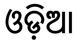
Odia (, ISO: , ; formerly rendered Oriya ) is an Indo-Aryan language spoken in the Indian state of Odisha. It is the official language in Odisha (formerly rendered Orissa), where native speakers make up 82% of the population, and it is also spoken in parts of West Bengal, Jharkhand, Andhra Pradesh and Chhattisgarh. Odia is one of the many official languages of India; it is the official language of Odisha and the second official language of Jharkhand. The language is also spoken by a sizeable population of 700,000 people in Chhattisgarh. Odia is the sixth Indian language to be designated a classical language, on the basis of having a long literary history and not having borrowed extensively from other languages. The earliest known inscription in Odia dates back to the 10th century CE. History Odia is an Eastern Indo-Aryan language belonging to the Indo-Aryan language family. It descends from Odra Prakrit, which evolved from Magadhi Prakrit, which was spoken in east India ... [...More Info...] [...Related Items...] OR: [Wikipedia] [Google] [Baidu] |
Central Provinces
The Central Provinces was a province of British India. It comprised British conquests from the Mughals and Marathas in central India, and covered parts of present-day Madhya Pradesh, Chhattisgarh and Maharashtra states. Its capital was Nagpur. Its Summer Capital was Pachmarhi. It became the Central Provinces and Berar in 1903. The Central Provinces was formed in 1861 by the merger of the Saugor and Nerbudda Territories and Nagpur Province. The district of Nimar which was administered by the Central India Agency was added in 1864. It was almost an island encircled by a sea of "native States" such as Bhopal State and Rewa State to the north, the Chota Nagpur States and Kalahandi State to the east, and the Nizam's territories of Hyderabad to the south and Berar to the west. Geography The Central Provinces was landlocked, occupying the mountain ranges, plateaus, and river valleys in the centre of the Indian Subcontinent. The northernmost portion of the state extended onto the Bun ... [...More Info...] [...Related Items...] OR: [Wikipedia] [Google] [Baidu] |


.jpg)

