|
Chorlton-cum-Hardy Railway Station
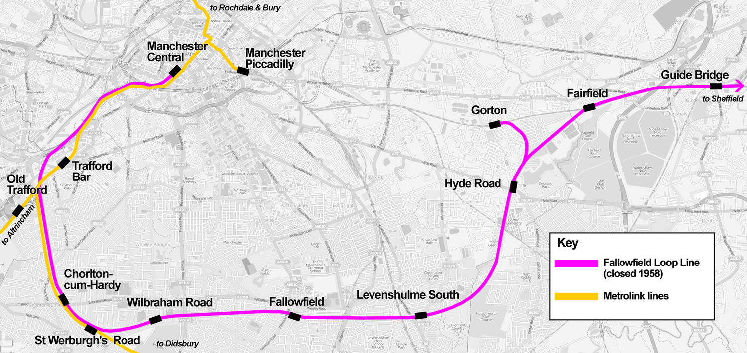
Chorlton is a stop on the South Manchester Line (SML) and Airport Line of the Metrolink light-rail system in Chorlton-cum-Hardy, Manchester, England. It was built as part of Phase 3a of the network's expansion, and opened on 7 July 2011 on a section of the former Cheshire Lines Committee railway. History Railway station Chorlton-cum-Hardy railway station opened on 1 January 1880 by the Midland Railway on the Manchester South District Railway. It later became Cheshire Lines Committee and closed on 2 January 1967 as part of the Beeching Axe, though the line through Fallowfield remained open to freight until the 1980s. Until the mid-20th century the station yard supplied coal to the district. Land to the north-east of the track originally acquired for the purpose of doubling it was eventually sold off for development. The station was mentioned in the 1964 song " Slow Train" by Flanders and Swann, which was written to lament the loss of stations resulting from the Beeching cuts: ... [...More Info...] [...Related Items...] OR: [Wikipedia] [Google] [Baidu] |
Manchester Metrolink
Manchester Metrolink (branded locally simply as Metrolink) is a tram/ light rail system in Greater Manchester, England. The network has 99 stops along of standard-gauge route, making it the most extensive light rail system in the United Kingdom. Metrolink is owned by the public body Transport for Greater Manchester (TfGM) and operated and maintained under contract by a Keolis/ Amey consortium. In 2021/22, 26 million passenger journeys were made on the system. The network consists of eight lines which radiate from Manchester city centre to termini at Altrincham, Ashton-under-Lyne, Bury, East Didsbury, Eccles, Manchester Airport, Rochdale and Trafford Centre. It runs on a mixture of on-street track shared with other traffic; reserved track sections segregated from other traffic, and converted former railway lines. Metrolink is operated by a fleet of 147 high-floor Bombardier M5000 light rail vehicles. Each service runs to a 12-minute headway; stops with more than one serv ... [...More Info...] [...Related Items...] OR: [Wikipedia] [Google] [Baidu] |
Morrisons
Wm Morrison Supermarkets, trading as Morrisons, is the fifth largest supermarket chain in the United Kingdom. As of 2021, the company had 497 supermarkets across England, Wales and Scotland, as well as one in Gibraltar. The company is headquartered in Bradford, England. Founded in 1899 by William Morrison, hence the abbreviation Wm Morrison, it began as an egg and butter stall in Rawson Market, Bradford, England. Until 2004, Morrisons store locations were focused primarily in the North of England but, with the takeover of Safeway in that year, the company's presence increased significantly in the South of England, Wales and Scotland. As of February 2021, Morrisons employed 110,000 employees and served around 11 million customers each week. The company was listed on the London Stock Exchange until it was acquired by Clayton, Dubilier & Rice in October 2021. Morrisons' UK market share in September 2022 was 9.1% – behind Tesco (26.9%), Sainsbury's (14.6%), Asda (14.1%) an ... [...More Info...] [...Related Items...] OR: [Wikipedia] [Google] [Baidu] |
Manchester Airport Station
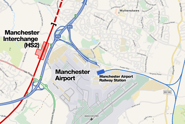
Manchester Airport station is a railway, tram, bus and coach station at Manchester Airport, England which opened at the same time as the second air terminal in 1993. The station is south of Manchester Piccadilly, at the end of a short branch from the Styal Line via a triangular junction between Heald Green and Styal stations. Manchester Metrolink tram services were extended to the airport in 2014 and operate to Manchester Victoria. Description The station is south of at the end of a short branch from the Styal Line constructed by British Rail in 1993. A branch of Manchester Metrolink runs into it. It is accessed via a triangular junction located between and . The station platforms are connected by escalator, lift, ramps and an elevated covered walkway (known as the "Sky Link") to the airport terminal buildings in which is a staffed railway ticket office. Throughout the airport complex, the railway station is known as "The Station" and is signposted as such. History New ... [...More Info...] [...Related Items...] OR: [Wikipedia] [Google] [Baidu] |
Manchester Victoria Station
Manchester Victoria station in Manchester, England is a combined mainline railway station and Metrolink tram stop. Situated to the north of the city centre on Hunts Bank, close to Manchester Cathedral, it adjoins Manchester Arena which was constructed on part of the former station site in the 1990s. Opened in 1844 and part of the Manchester station group, Victoria is Manchester's third busiest railway station after Piccadilly and Oxford Road and the second busiest station managed by Northern after Oxford Road. The station hosts local and regional services to destinations in Northern England, such as , , Bradford, , , , Halifax, Wigan, , Blackpool (Sundays only) and Liverpool using the original Liverpool to Manchester line. Most trains calling at Victoria are operated by Northern. TransPennine Express services call at the station from Liverpool to Newcastle/Scarborough and services towards Manchester Airport (via the Ordsall Chord) from Middlesbrough/Redcar/Newcastle. Manche ... [...More Info...] [...Related Items...] OR: [Wikipedia] [Google] [Baidu] |
Shaw And Crompton Tram Stop
Shaw and Crompton is a tram stop on the Oldham and Rochdale Line (ORL) of Greater Manchester's light-rail Metrolink system. It opened to passengers on 16 December 2012 and is located in Shaw and Crompton, a part of the Metropolitan Borough of Oldham, England. The station sits adjacent to the site of the original Shaw and Crompton railway station, a regional rail station which opened (initially for haulage) on 2 November 1863 and closed on 3 October 2009 for conversion to Metrolink. Known as Shaw railway station between 1974 and 1989, it was along the Oldham Loop Line, which operated from Manchester to Rochdale via Oldham and thus was almost identical to the current Metrolink route. History The railway line between and was first proposed in 1845, but not authorised until 1859. The line was opened to freight trains on 12 August 1863, and for passengers on 2 November. One of the four new stations opened that day was Shaw, from Oldham Mumps. The new line from Oldham Mumps ... [...More Info...] [...Related Items...] OR: [Wikipedia] [Google] [Baidu] |
East Didsbury Tram Stop
East Didsbury is a tram stop on Greater Manchester's light rail Metrolink system and the terminus of the system's South Manchester Line (SML). It is on the east side of Kingsway in East Didsbury, close to Manchester's boundary with Heaton Mersey in the Metropolitan Borough of Stockport. It was built as part of Phase 3b of the network's expansion and opened on 23 May 2013. History East Didsbury tram stop was built on the Midland Railway's former Manchester South District line from Manchester Central Station. East Didsbury Metrolink station is north-east of East Didsbury railway station, which is a National Rail station on the Styal Line. Together with West Didsbury and Didsbury Village Metrolink stops, East Didsbury had been a feature of proposals to extend the Metrolink system since 1983. In 2006, it was announced that the CLC line would be re-opened as part of an expansion project, and that the extension would initially go only as far as St Werburgh's Road in a project ... [...More Info...] [...Related Items...] OR: [Wikipedia] [Google] [Baidu] |
Rochdale Town Centre Tram Stop
Rochdale Town Centre is a tram stop and the terminus on the Oldham and Rochdale Line (ORL) of Greater Manchester's light-rail Manchester Metrolink, Metrolink system. It was constructed as part of Phase 3b of the system's expansion, and is located on Smith Street, adjacent to Rochdale Interchange and Number One Riverside, in central Rochdale, England. It opened on 31 March 2014. Services Services are mostly every 12 minutes on all routes. References * https://web.archive.org/web/20120211143030/http://www.lrta.org/Manchester/Oldham_Rochdale.html External links Rochdale Town Centre Metrolink station stop information Tram stops in the Metropolitan Borough of Rochdale Tram stops on the East Didsbury to Rochdale line Rochdale {{UK-tram-stub ... [...More Info...] [...Related Items...] OR: [Wikipedia] [Google] [Baidu] |
Greater Manchester Transport Innovation Fund
The Greater Manchester Transport Innovation Fund was a failed bid by the Greater Manchester Passenger Transport Authority (GMPTA) and Association of Greater Manchester Authorities (AGMA) to secure £1.5 billion from the Transport Innovation Fund (TIF), a major public transport funding mechanism in England, for the metropolitan county of Greater Manchester. There would have been an additional £1.2 billion borrowed and paid back through a mixture of public transport revenues and weekday, peak-time only Greater Manchester congestion charge. If approved, the funds would have been spent on modernising Greater Manchester's transport network, with large-scale extensions of the Manchester Metrolink system, as well as increased bus and rail services, investment in existing stations and improvements to cycling and road networks. Other changes would have been the introduction of the Readycard, an Integrated Transport Smartcard Organisation, Integrated Transport Smartcard similar to the O ... [...More Info...] [...Related Items...] OR: [Wikipedia] [Google] [Baidu] |
St Werburgh's Road Metrolink Station
St Werburgh's Road is a tram stop on the South Manchester Line (SML) and Airport Line of Greater Manchester's light-rail Metrolink system in Chorlton-cum-Hardy, Manchester. It was built as part of Phase 3a of the network's expansion and opened on 7 July 2011. Consisting of an island platform to the east of St Werburgh's Road, the stop is built largely on the site of the former Chorlton Junction Signal Box and its surroundings. It serves as an interchange for passengers travelling towards either Manchester Airport or . History St Werburgh's Road stop is on a re-opened railway line, the Cheshire Lines Committee line, which closed to passenger service in 1967. It was planned to reopen the line as part of the expansion of the Manchester Metrolink tram network. Proposals to re-open the line have been put forward since the 1980s, - publicity brochure but remained unfunded until the 2000s. The line extension which was originally proposed would take over the disused trackbed of the Ch ... [...More Info...] [...Related Items...] OR: [Wikipedia] [Google] [Baidu] |
National Cycle Network
The National Cycle Network (NCN) is the national cycling route network of the United Kingdom, which was established to encourage cycling and walking throughout Britain, as well as for the purposes of bicycle touring. It was created by the charity Sustrans who were aided by a £42.5 million National Lottery grant. However Sustrans themselves only own around 2% of the paths on the network, these rest being made of existing public highways and rights of way, and permissive paths negotiated by Sustrans with private landowners, which Sustrans have then labelled as part of their network. In 2017, the Network was used for over 786 million cycling and walking trips, made by 4.4 million people. In 2020, around a quarter the NCN was scrapped on safety grounds, leaving of signed routes. These are made up of of traffic-free paths with the remaining on-road. It uses shared use paths, disused railways, minor roads, canal towpaths and traffic-calmed routes in towns and cit ... [...More Info...] [...Related Items...] OR: [Wikipedia] [Google] [Baidu] |
Sustrans
Sustrans is a United Kingdom-based walking, wheeling and cycling charity, and the custodian of the National Cycle Network. Its flagship project is the National Cycle Network, which has created of signed cycle routes throughout the United Kingdom including of traffic-free paths. The rest of the network is on previously existing and mostly minor roads, in which motor traffic will be encountered. Sustrans works with schools to encourage active travel (cycling, walking or scooting) among students. It also works with employers and local authorities. It administers several thousand volunteers who contribute their time to the charity in numerous ways, such as cleaning and maintaining the National Cycle Network, enhancing biodiversity along the routes, leading walks and rides and supporting communities to improve their air quality. In Scotland, Sustrans has established partnership teams, embedding officers in local councils as well as NHS Scotland, the Scottish Environment Protecti ... [...More Info...] [...Related Items...] OR: [Wikipedia] [Google] [Baidu] |
Cycle Track
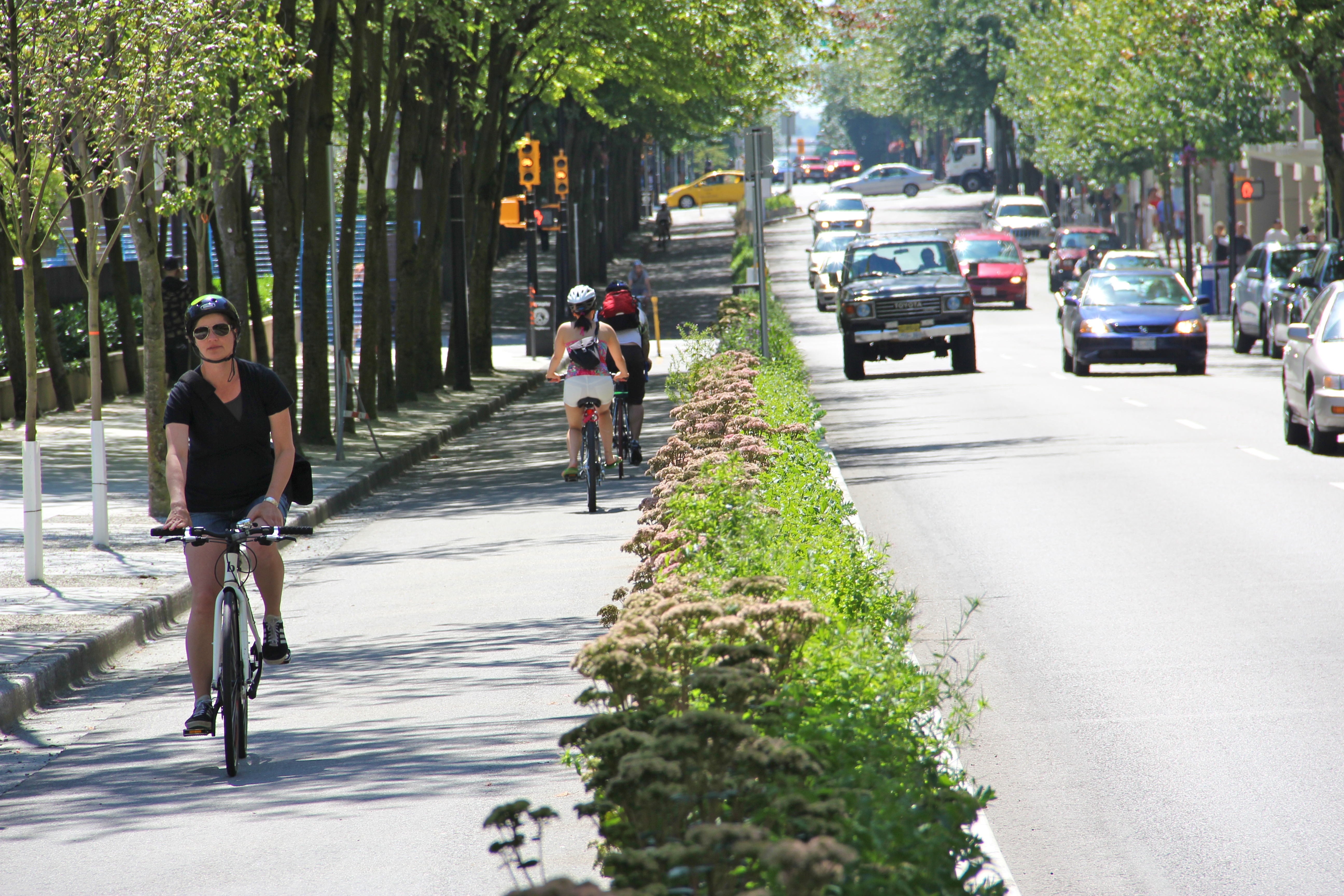
A cycle track, separated bike lane or protected bike lane (sometimes historically referred to as a sidepath) is an exclusive bikeway that has elements of a separated path and on-road bike lane. A cycle track is located within or next to the roadway, but is made distinct from both the sidewalk and general purpose roadway by vertical barriers or elevation differences. In urban planning, cycle tracks are designed to encourage bicycling in an effort to relieve automobile congestion and reduce pollution, reduce bicycling fatalities and injuries by eliminating the need for cars and bicycles to jockey for the same road space, and to reduce overall confusion and tension for all users of the road. Cycle tracks may be one-way or two-way, and may be at road level, at sidewalk level, or at an intermediate level. They all have in common some separation from motor traffic with bollards, car parking, barriers or boulevards. Barriers may include curbs, concrete berms, posts, planting/median ... [...More Info...] [...Related Items...] OR: [Wikipedia] [Google] [Baidu] |

.jpg)


