|
Chiaha
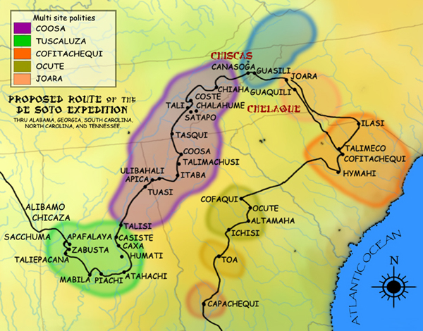
Chiaha was a Native American chiefdom located in the lower French Broad River valley in modern East Tennessee, in the southeastern United States. They lived in raised structures within boundaries of several stable villages. These overlooked the fields of maize, beans, squash, and tobacco, among other plants which they cultivated. Chiaha was the northern extreme of the paramount Coosa chiefdom's sphere of influence in the 16th century when the Spanish expeditions of Hernando de Soto and Juan Pardo passed through the area. The Chiaha chiefdom included parts of modern Jefferson and Sevier counties, and may have extended westward into Knox, Blount and Monroe counties. The Spanish explorers' accounts of Chiaha provide a rare first-hand glimpse of life in a Dallas phase Mississippian-era village. The Dallas culture, named after Dallas Island near Chattanooga, where its distinct characteristics were first observed, dominated much of East Tennessee between approximately 1300 and ... [...More Info...] [...Related Items...] OR: [Wikipedia] [Google] [Baidu] |
Joara
Joara was a large Native American settlement, a regional chiefdom of the Mississippian culture, located in what is now Burke County, North Carolina, about 300 miles from the Atlantic coast in the foothills of the Blue Ridge Mountains. Joara is notable as a significant archaeological and historic site, where Mississippian culture-era and European artifacts have been found, in addition to an earthwork platform mound and remains of a 16th-century Spanish fort. The first European encounters came in the mid-16th century. In 1540 the party of Spanish conquistador Hernando De Soto recorded visiting this place. A later expedition in 1567 under Juan Pardo, another Spanish explorer, founded the first European settlement in the interior of the continent, establishing Fort San Juan at this site, followed by other forts to the west. [...More Info...] [...Related Items...] OR: [Wikipedia] [Google] [Baidu] |
Cherokee
The Cherokee (; chr, ᎠᏂᏴᏫᏯᎢ, translit=Aniyvwiyaʔi or Anigiduwagi, or chr, ᏣᎳᎩ, links=no, translit=Tsalagi) are one of the indigenous peoples of the Southeastern Woodlands of the United States. Prior to the 18th century, they were concentrated in their homelands, in towns along river valleys of what is now southwestern North Carolina, southeastern Tennessee, edges of western South Carolina, northern Georgia, and northeastern Alabama. The Cherokee language is part of the Iroquoian language group. In the 19th century, James Mooney, an early American ethnographer, recorded one oral tradition that told of the tribe having migrated south in ancient times from the Great Lakes region, where other Iroquoian peoples have been based. However, anthropologist Thomas R. Whyte, writing in 2007, dated the split among the peoples as occurring earlier. He believes that the origin of the proto-Iroquoian language was likely the Appalachian region, and the split betw ... [...More Info...] [...Related Items...] OR: [Wikipedia] [Google] [Baidu] |
East Tennessee
East Tennessee is one of the three Grand Divisions of Tennessee defined in state law. Geographically and socioculturally distinct, it comprises approximately the eastern third of the U.S. state of Tennessee. East Tennessee consists of 33 counties, 30 located within the Eastern Time Zone and three counties in the Central Time Zone, namely Bledsoe, Cumberland, and Marion. East Tennessee is entirely located within the Appalachian Mountains, although the landforms range from densely forested mountains to broad river valleys. The region contains the major cities of Knoxville and Chattanooga, Tennessee's third and fourth largest cities, respectively, and the Tri-Cities, the state's sixth largest population center. During the American Civil War, many East Tennesseans remained loyal to the Union even as the state seceded and joined the Confederacy. Early in the war, Unionist delegates unsuccessfully attempted to split East Tennessee into a separate state that would remain as part ... [...More Info...] [...Related Items...] OR: [Wikipedia] [Google] [Baidu] |
Sevier County, Tennessee
Sevier County ( ) is a county of the U.S. state of Tennessee. As of the 2020 census, the population was 98,380. Its county seat and largest city is Sevierville. Sevier County comprises the Sevierville, TN Micropolitan Statistical Area, which is included in the Knoxville- Morristown-Sevierville, TN Combined Statistical Area. History Prior to the arrival of white settlers in present-day Sevier County in the mid-18th century, the area had been inhabited for as many as 20,000 years by nomadic and semi-nomadic Native Americans. In the mid-16th century, Spanish expeditions led by Hernando de Soto (1540) and Juan Pardo (1567) passed through what is now Sevier County, reporting that the region was part of the domain of Chiaha, a minor Muskogean chiefdom centered around a village located on a now-submerged island just upstream from modern Douglas Dam. By the late 17th-century, however, the Cherokee, whose ancestors were living in the mountains at the time of the Spaniards' visit, ha ... [...More Info...] [...Related Items...] OR: [Wikipedia] [Google] [Baidu] |
Juan Pardo (explorer)
Juan Pardo was a Spanish explorer who was active in the later half of the sixteenth century. He led a Spanish expedition from the Atlantic coast through what is now North and South Carolina and into eastern Tennessee on the orders of Pedro Menéndez de Avilés, in an attempt to find an inland route to a silver-producing town in Mexico. Menéndez had built Fort San Felipe (1566), and established Santa Elena, on present-day Parris Island; these were the first Spanish settlements in what is now South Carolina. While leading his expedition deeper into the interior, Pardo founded Fort San Juan at Joara, the first European settlement (1567–1568) in the interior of North Carolina, and five additional forts in what are the modern US states of North Carolina, Tennessee, and South Carolina. These five forts were Fort San Pedro near Chiaha, Fort San Pablo on the French Broad River, Fort Santiago near modern Salisbury, North Carolina, Fort Santo Tomás near Cofitachequi, and Fuerta de N ... [...More Info...] [...Related Items...] OR: [Wikipedia] [Google] [Baidu] |
Dallas Phase
The Dallas phase (c. 1300–1600 CE) is an archaeological phase, within the Mississippian III period, in the South Appalachian Geologic province in North America.Sullivan and Prezzano 281 Geography Dallas peoples moved into what is now southwest Virginia from northeastern Tennessee in the early 13th century.Sullivan and Prezzano 220 Dallas phase settlements ranged from along the Holston River to Cobb Island, and up the Nolichucky River and Little Pigeon Creek in Tennessee, and along the Clinch River in Virginia.Sullivan and Prezzano 208 Characteristics The Dallas phase settlements typically have one to three platform mounds; however, some (40Un11 and 40An44) have no mounds at all. Their society was hierarchical. It is characterized by distinctions between nobles and commoners in burial practices. Elites were buried in mounds, unlike the remaining population. Artifacts included shell gorgets, ear pins, and beads. Dallas peoples built "large log houses." Their towns had central ... [...More Info...] [...Related Items...] OR: [Wikipedia] [Google] [Baidu] |
Douglas Dam
Douglas Dam is a hydroelectric dam on the French Broad River in Sevier County, Tennessee, in the southeastern United States. The dam is operated by the Tennessee Valley Authority (TVA), which built the dam in record time in the early 1940s to meet emergency energy demands at the height of World War II. Douglas Dam is a straight reinforced concrete gravity-type dam 1705 feet (520 m) long and 202 feet (62 m) high, impounding the Douglas Lake. The dam was named for Douglas Bluff, a cliff overlooking the dam site prior to construction.Tennessee Valley Authority, ''The Douglas Project: A Comprehensive Report on the Planning, Design, Construction, and Initial Operations of the Douglas Project'', Technical Report No. 10 (Washington, D.C.: U.S. Government Printing Office, 1949), pp. 1–12, 28. Location and access The French Broad River winds its way westward from the Appalachian Mountains, gaining considerable strength after absorbing the Pigeon River and Nolichucky River near Ne ... [...More Info...] [...Related Items...] OR: [Wikipedia] [Google] [Baidu] |
Cofitachequi
Cofitachequi was a paramount chiefdom founded about 1300 AD and encountered by the Hernando de Soto expedition in South Carolina in April 1540. Cofitachequi was later visited by Juan Pardo during his two expeditions (1566–1568) and by Henry Woodward in 1670. Cofitachequi ceased to exist as a political entity prior to 1701. The town and ceremonial center of Cofitachequi was located near the present-day city of Camden, South Carolina. Cofitachequi ruled a large number of towns in an area of several thousand square miles in the northeastern part of South Carolina. It was the easternmost manifestation of the Mississippian culture that extended over much of the southern part of the future United States. Location The hunt for the location of Cofitachequi has been stimulated by the century-old search for the route of Hernando de Soto in his 4-year traverse of much of the southeastern United States. The Spaniards described Cofitachequi as about 10 days travel eastward from Ocute ... [...More Info...] [...Related Items...] OR: [Wikipedia] [Google] [Baidu] |
Georgia (U
Georgia most commonly refers to: * Georgia (country), a country in the Caucasus region of Eurasia * Georgia (U.S. state), a state in the Southeast United States Georgia may also refer to: Places Historical states and entities * Related to the country in the Caucasus ** Kingdom of Georgia, a medieval kingdom ** Georgia within the Russian Empire ** Democratic Republic of Georgia, established following the Russian Revolution ** Georgian Soviet Socialist Republic, a constituent of the Soviet Union * Related to the US state ** Province of Georgia, one of the thirteen American colonies established by Great Britain in what became the United States ** Georgia in the American Civil War, the State of Georgia within the Confederate States of America. Other places * 359 Georgia, an asteroid * New Georgia, Solomon Islands * South Georgia and the South Sandwich Islands Canada * Georgia Street, in Vancouver, British Columbia, Canada * Strait of Georgia, British Columbia, Canada United K ... [...More Info...] [...Related Items...] OR: [Wikipedia] [Google] [Baidu] |
Paramount Chiefdom
A paramount chief is the English-language designation for the highest-level political leader in a regional or local polity or country administered politically with a chief-based system. This term is used occasionally in anthropological and archaeological theory to refer to the rulers of multiple chiefdoms or the rulers of exceptionally powerful chiefdoms that have subordinated others. Paramount chiefs were identified by English-speakers as existing in Native American confederacies and regional chiefdoms, such as the Powhatan Confederacy and Piscataway Native Americans encountered by European colonists in the Chesapeake Bay region of North America. During the Victoria era, paramount chief was a formal title created by British colonial administrators in the British Empire and applied in Britain's colonies in Asia and Africa. They used it as a substitute for the word "king" to ensure that only the British monarch held that title.Government Documents. Great Britain. Foreign Offic ... [...More Info...] [...Related Items...] OR: [Wikipedia] [Google] [Baidu] |


