|
Charles E. Bell
Charles Emlen Bell (1858–1932), often known as C.E. Bell, was an American architect of Council Bluffs, Iowa and Minneapolis, Minnesota. He worked alone and in partnership with John H. Kent and Menno S. Detweiler. He also worked as part of Bell, Tyrie and Chapman. A number of his works are listed on the U.S. National Register of Historic Places. Biography and career Bell was born in McLean County, Illinois on March 31, 1858, and was educated at West Town Boarding School, Philadelphia, Pennsylvania, U.S. In 1880, he married Helen Louise "Nellie" Wickham (1858–1913), and they moved to Council Bluffs, Iowa in 1884. Bell began his career as a carpenter and worked on the construction of the post office in Council Bluffs. He and John Kent established a partnership, and won the competition to design the Montana State Capitol. They opened an office in Helena, Montana for the project. Bell moved to Minneapolis, Minnesota and set up a partnership with Menno Detweiler. From 1904 unt ... [...More Info...] [...Related Items...] OR: [Wikipedia] [Google] [Baidu] |
Cass County Court House, Jail, And Sheriff's House
Cass County Court House, Jail, and Sheriff's House is a property in Fargo, North Dakota that was listed on the National Register of Historic Places in 1983. It was built in 1904 in Late 19th and 20th Century Revivals architecture style, and was designed by architect Charles E. Bell. The listing included three contributing buildings In the law regulating historic districts in the United States, a contributing property or contributing resource is any building, object, or structure which adds to the historical integrity or architectural qualities that make the historic distric ... on an area of less than . Its buildings served historically as a courthouse, as a correctional facility, and as a single dwelling. The courthouse "is significant architecturally as Fargo's premier example of Renaissance Revival style architecture". and The property was covered in a study of North Dakota county courthouses. References Jails on the National Register of Historic Places in N ... [...More Info...] [...Related Items...] OR: [Wikipedia] [Google] [Baidu] |
Fairmont, Minnesota
Fairmont is a city in and the county seat of Martin County, Minnesota, United States. The population was 10,487 at the 2020 census. History Fairmont was platted in 1857. The city was so named on account of its elevated town site. A post office has been in operation at Fairmont since 1858. Fairmont was incorporated as a city in 1902. Geography According to the United States Census Bureau, the city has a total area of , of which is land and is water. The city of Fairmont itself has been built around a chain of five lakes: Lake George, Sisseton Lake, Budd Lake, Hall Lake, and Amber Lake. All except Amber Lake are connected by channels and are used extensively for recreational boating and fishing. Interstate 90 and Minnesota State Highway 15 are two of the main routes in the city. Demographics 2010 census As of the census of 2010, there were 10,666 people, 4,812 households, and 2,816 families living in the city. The population density was . There were 5,251 housing units at a ... [...More Info...] [...Related Items...] OR: [Wikipedia] [Google] [Baidu] |
Britton, South Dakota
Britton is a city in and the county seat of Marshall County, South Dakota, United States. The population was 1,215 at the 2020 census. A weekly newspaper, the ''Britton Journal,'' is published in Britton. History Britton was founded in 1884 as a stop on the Chicago, Milwaukee, St. Paul and Pacific Railroad. In 1885, the town was designated county seat of the newly formed Marshall County. It received its city rights in 1906. The city is named after Isaac Britton, a railroad official. Geography Britton is located at (45.792817, -97.752912). According to the United States Census Bureau, the city has a total area of , all land. Britton has been assigned the ZIP code 57430 and the FIPS place code 07380. Climate Demographics 2010 census As of the census of 2010, there were 1,241 people, 574 households, and 313 families living in the city. The population density was . There were 658 housing units at an average density of . The racial makeup of the city was 97.8% White, 0.5% ... [...More Info...] [...Related Items...] OR: [Wikipedia] [Google] [Baidu] |
Marshall County Courthouse (South Dakota)
The Marshall County Courthouse in Britton, in the state of South Dakota in the Midwestern United States, was built in 1908. It was listed on the National Register of Historic Places The National Register of Historic Places (NRHP) is the United States federal government's official list of districts, sites, buildings, structures and objects deemed worthy of preservation for their historical significance or "great artistic v ... in 2006. It is a three-and-a-half-story building. It replaced use of the former Arlington Hotel as county courthouse, and solidified the selection of Britton as the county seat of Marshall County. References Courthouses on the National Register of Historic Places in South Dakota Renaissance Revival architecture in South Dakota Government buildings completed in 1908 Buildings and structures in Marshall County, South Dakota County courthouses in South Dakota National Register of Historic Places in Marshall County, South Dakota 1908 establi ... [...More Info...] [...Related Items...] OR: [Wikipedia] [Google] [Baidu] |
International Falls, Minnesota
International Falls (sometimes referred to as I-Falls) is a city in and the county seat of Koochiching County, Minnesota. The population was 5,802 at the time of the 2020 census. International Falls is located on the Rainy River directly across from Fort Frances, Ontario, Canada. The two cities are connected by the Fort Frances–International Falls International Bridge. Voyageurs National Park is located 11 miles east of International Falls. There is a major U.S. Customs and Border Protection Port of Entry on the International Falls side of the toll bridge and a Canadian Customs entry point on the north side of the bridge. International Falls is nicknamed the "Icebox of the Nation,” with an average of 109.4 days per year with a high temperature below . History The area now known as International Falls was inhabited by many indigenous peoples. The International Falls area was well known to explorers, missionaries, and voyagers as early as the 17th century. It was not until ... [...More Info...] [...Related Items...] OR: [Wikipedia] [Google] [Baidu] |
Koochiching County Courthouse
The Koochiching County Courthouse is a Classical Revival brick building in International Falls, Minnesota, United States. It was designed by Charles E. Bell Charles Emlen Bell (1858–1932), often known as C.E. Bell, was an American architect of Council Bluffs, Iowa and Minneapolis, Minnesota. He worked alone and in partnership with John H. Kent and Menno S. Detweiler. He also worked as part of Be ... and completed in 1909. See also * National Register of Historic Places listings in Koochiching County, Minnesota References External links Koochiching County District Court {{National Register of Historic Places in Minnesota County courthouses in Minnesota Courthouses on the National Register of Historic Places in Minnesota Government buildings completed in 1909 National Register of Historic Places in Koochiching County, Minnesota ... [...More Info...] [...Related Items...] OR: [Wikipedia] [Google] [Baidu] |
Harlan, Iowa
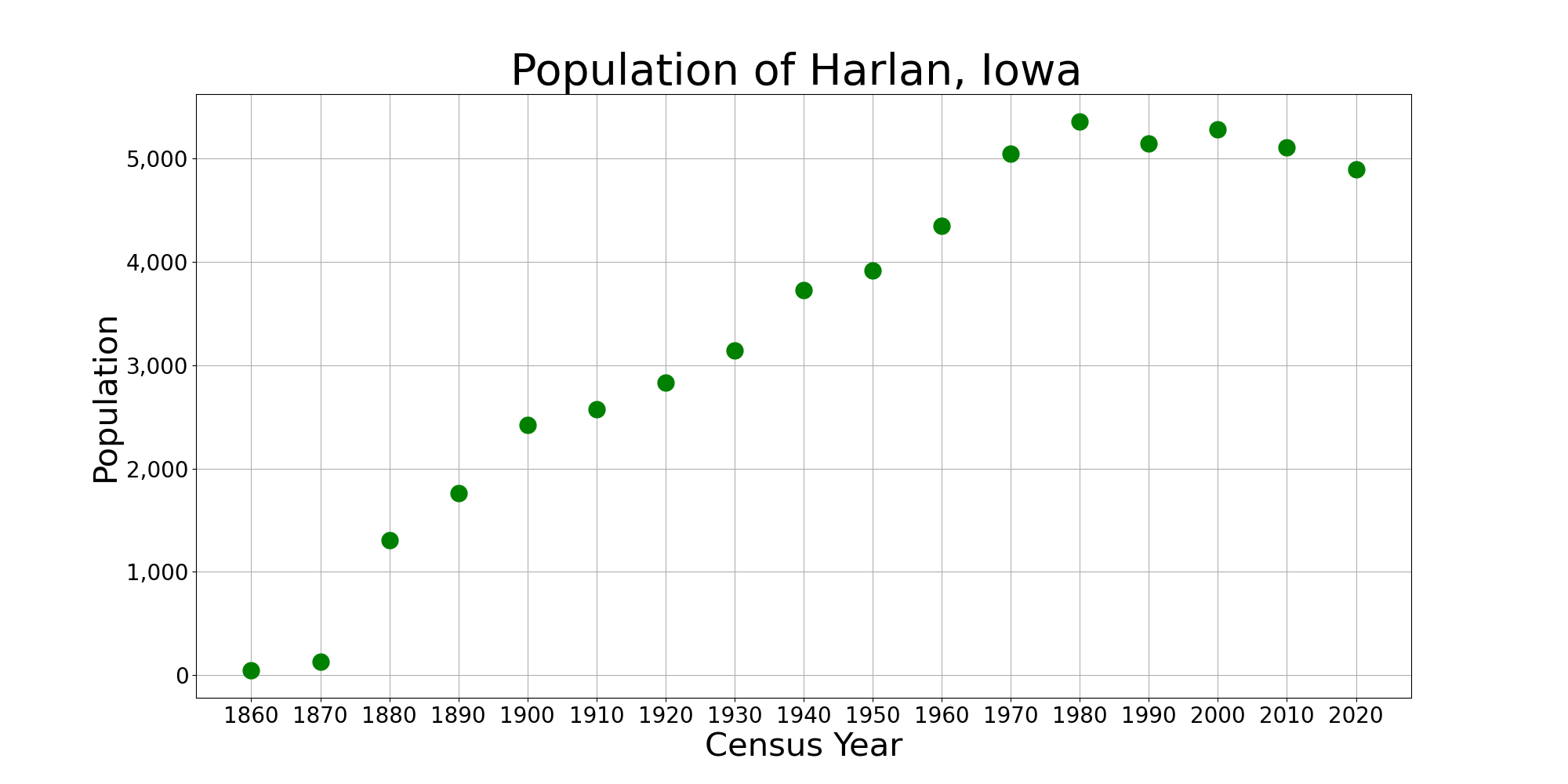
Harlan is a city in Shelby County, Iowa, along the West Nishnabotna River. The population was 4,893 at the time of the 2020 census. It is the county seat of Shelby County. History Harlan was platted in 1858. It was named for one of Iowa's early U.S. Senators, James Harlan. Harlan was designated county seat in 1859. The town was incorporated on May 2, 1879. Geography Harlan's longitude and latitude coordinates in decimal form are 41.654609, -95.322019. According to the United States Census Bureau, the city has a total area of , all of it land. Climate Demographics 2020 census At the 2020 census there were 4,893 people, 2,288 households, and 1,275 families living in the city. The population density was . There were 2,348 housing units at an average density of . The racial makeup of the city was 90.8% White, 0.8% African American, 0.5% Native American, 0.8% Asian, 2.5% from other races, and 4.3% from two or more races. Hispanic or Latino of any race were 4.6%. Of the 2,288 ... [...More Info...] [...Related Items...] OR: [Wikipedia] [Google] [Baidu] |
Harlan Courthouse Square Commercial District
Harlan Courthouse Square Commercial District is a nationally recognized historic district located in Harlan, Iowa, United States. It was listed on the National Register of Historic Places in 1994. At the time of its nomination the district consisted of 54 resources, including 38 contributing buildings, one contributing site, one contributing object, 13 noncontributing buildings, and one noncontributing object. with Cross-shaped in plan, the historic district covers most of the city's central business district in the original town plat. Most of the buildings are two-story, brick, commercial buildings. Commercial Italianate and Queen Anne styles are dominant. The Shelby County Courthouse (1893) is a stone Richardsonian Romanesque Richardsonian Romanesque is a style of Romanesque Revival architecture named after the American architect Henry Hobson Richardson (1838–1886). The revival style incorporates 11th and 12th century southern French, Spanish, and Italian Romanesque ... [...More Info...] [...Related Items...] OR: [Wikipedia] [Google] [Baidu] |
Milbank, South Dakota
Milbank is a city in Grant County, South Dakota, United States, located along the South Fork of the Whetstone River. The population was 3,544 at the 2020 census. It is the county seat of Grant County. Milbank is the birthplace of American Legion Baseball. The program was created in Milbank in 1925 and is now enjoyed by high school aged youth on more than five thousand teams in all fifty states. History The city was founded in 1880 when the Chicago, Milwaukee and St. Paul Railway first laid rails into South Dakota, and was named in honor of railroad director Jeremiah Milbank. The city was incorporated in 1881. Geography Milbank is located at (45.218583, -96.633721). According to the United States Census Bureau, the city has a total area of , of which is land and is water. Milbank has been assigned the ZIP code range 57252-57253 and the FIPS place code 42260. Demographics 2010 census As of the census of 2010, there were 3,353 people, 1,508 households, and 898 families ... [...More Info...] [...Related Items...] OR: [Wikipedia] [Google] [Baidu] |
Grant County Courthouse (South Dakota)
The Grant County Courthouse is an historic building located at Park Avenue and Main Street in Milbank, South Dakota. It was built in 1915 in the Classical Revival style and was designed by architects Bell & Bentley of Minneapolis, who also designed the South Dakota State Capitol in Pierre. On February 10, 1993, it was added to the National Register of Historic Places The National Register of Historic Places (NRHP) is the United States federal government's official list of districts, sites, buildings, structures and objects deemed worthy of preservation for their historical significance or "great artistic v .... References County courthouses in South Dakota Buildings and structures in Grant County, South Dakota Courthouses on the National Register of Historic Places in South Dakota National Register of Historic Places in Grant County, South Dakota {{SouthDakota-NRHP-stub ... [...More Info...] [...Related Items...] OR: [Wikipedia] [Google] [Baidu] |
Clark, South Dakota
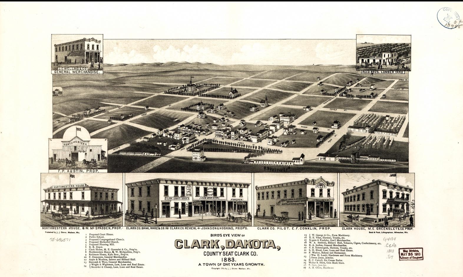
Clark is a city in and county seat of Clark County, South Dakota, United States. The population was 1,148 at the 2020 census. History A post office was established at Clark in 1880. Clark was platted in 1882. The city took its name from Clark County. An early variant name was Clark Center. In 1882, railroad tracks were first built through the middle of Clark. The Burlington Northern railroad and County Highway 212 ran parallel to one another and divided Clark into halves - the north half and the south half. Highway 212 similarly runs through the middle of Clark, and provides a direct travel route starting in Minneapolis, Minnesota, into Clark, then went to the Black Hills and to Yellowstone National Park. Clark was officially founded in 1886, three years before South Dakota became a state. Not long after in June 1899, the local government took action, and the Clark City Council passed Ordinance No. 26. Serving as one of the first regulations enacted in Clark, Ordinance No. ... [...More Info...] [...Related Items...] OR: [Wikipedia] [Google] [Baidu] |


