|
Central Polynesian Tropical Moist Forests
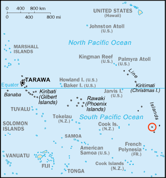
The Central Polynesian tropical moist forests is a tropical and subtropical moist broadleaf forests ecoregion in Polynesia. It includes the northern group of the Cook Islands, the Line Islands in Kiribati, and Johnston Atoll, Jarvis Island, Palmyra Atoll, and Kingman Reef which are possessions of the United States. Geography All the islands in the ecoregion are atolls, low islands of coral sand surrounding a central lagoon. There are eight inhabited and nine uninhabited atolls. The Line Islands run north-northwest to south-southeast for 2,350 miles, crossing the equator. The northernmost, Kingman Reef, is at 6°24′N latitude and 162°24′W longitude. The southernmost is Flint Island at 11°26′S latitude and 151° 48′W longitude. Teraina, Tabuaeran, Kiritimati, Malden, Starbuck, Vostok, Caroline, and Flint are part of Kiribati. Kingman Reef, Palmyra Atoll, and Jarvis Island are territories of the United States. Kiritimati is the largest island in the 388 square kilome ... [...More Info...] [...Related Items...] OR: [Wikipedia] [Google] [Baidu] |
Black Noddy
The black noddy or white-capped noddy (''Anous minutus'') is a seabird from the family Laridae. It is a medium-sized species of tern with black plumage and a white cap. It closely resembles the lesser noddy (''Anous tenuirostris'') with which it was at one time considered conspecific. The black noddy has slightly darker plumage and dark rather than pale lores. Taxonomy The black noddy was first formally described by German naturalist and lawyer Friedrich Boie in 1844 under its current binomial name. The genus name ''Anous'' is ancient Greek for "stupid" or "foolish". The specific name ''minutus'' is the Latin for "small". There are seven subspecies: *''A. m. worcesteri'' (McGregor, 1911) – Cavilli Island and Tubbataha Reef ( Sulu Sea) *''A. m. minutus'' Boie, 1844 – northeast Australia and New Guinea to Tuamotu Archipelago *''A. m. marcusi'' (Bryan, 1903) – Marcus and Wake Islands through Micronesia to the Caroline Islands *''A. m. melanogenys'' Gray, 1846 – Hawaiian I ... [...More Info...] [...Related Items...] OR: [Wikipedia] [Google] [Baidu] |
Flint Island
Flint Island is an uninhabited coral island in the central Pacific Ocean, part of the Southern Line Islands under the jurisdiction of Kiribati. In 2014 the Kiribati government established a exclusion zone around each of the southern Line Islands (Caroline (commonly called Millennium), Flint, Vostok, Malden, and Starbuck). Geography Flint Island is located about northwest of Tahiti, south-southeast of Vostok Island, and southwest of Caroline Island. The island is about long and wide at its widest point (). It has a land area of and rises to a height of above sea level. The island is surrounded by a narrow fringing reef and with no safe anchorage, landing is difficult. According to the U.S. Exploring Expedition (February 5, 1841), the island was thickly wooded with primeval forest, however the island is now mostly covered with planted coconut palms. History Flint island was discovered by the Spanish expedition of Ferdinand Magellan on 4 February 1521, and charted as ... [...More Info...] [...Related Items...] OR: [Wikipedia] [Google] [Baidu] |
Suwarrow
200px, Map of Cook Islands with Suwarrow near the middle Suwarrow (also called Suvorov, Suvarou, or Suvarov) is an island in the northern group of the Cook Islands in the south Pacific Ocean. It is about south of the equator and north-northwest of the capital island of Rarotonga. Geography 200px, Anchorage Island Suwarrow is a roughly quadrilateral-shaped coral atoll, in circumference, with over 20 small islets (motu) surrounding a central lagoon . Cyclones have often created storm surges which sweep over the atoll since its small component of land is extremely low-lying. Table of Islets History Although Suwarrow was inhabited by Polynesians during prehistory it was uninhabited when discovered by the Russian-American Company ship ''Suvorov'', which reportedly followed clouds of birds to the atoll on September 17, 1814. (The ship was named after Russian general Alexander Suvorov, who appears as "Suwarrow" in Lord Byron's epic poem ''Don Juan'' and also in Alaric Alex ... [...More Info...] [...Related Items...] OR: [Wikipedia] [Google] [Baidu] |
Penrhyn Atoll
Penrhyn (also called Tongareva, Māngarongaro, Hararanga, and Te Pitaka) is an atoll in the northern group of the Cook Islands in the south Pacific Ocean. The northernmost island in the group, it is located at north-north-east of the capital island of Rarotonga, 9 degrees south of the equator. Its nearest neighbours are Rakahanga and Manihiki, approximately to the southwest. Once one of the most heavily populated atolls, it was almost completely depopulated by Peruvian slavers in 1864. Geography Penrhyn is a roughly circular coral atoll with a circumference of approximately , enclosing a lagoon with an area of . The atoll is atop the highest submarine volcano in the Cook Islands, rising from the ocean floor. The atoll is low-lying, with a maximum elevation of less than . The total land area is . The atoll rim consists of 18 major islets. Clockwise, from the Northwest, these are: * Tokerau * Painko * Ruahara * Takuua * Veseru * Tuirai * Pokerekere Islet * Kavea * ... [...More Info...] [...Related Items...] OR: [Wikipedia] [Google] [Baidu] |
Manihiki
250px, Map of Manihiki Atoll Manihiki is an atoll in the northern group of the Cook Islands known informally as the "Island of Pearls". It is located in the Northern Cook Island chain, approximately north of the capital island of Rarotonga, making it one of the most remote inhabitations in the Pacific Ocean. Its name has two possible meanings: It's believed that the original name of the island was Manuhiki, inspired by the aboriginal discovers ''Manu'' coming from the word Rua Manu (a kind of canoe) and ''Hiki'' meaning ''ashore'', so the literal translation would be ''canoe carried ashore''. The second interpretation is that the original discoverers were from Manihi, an island in Tuamotus, so the name of the island would mean ''Little Manihi''. Geography Manihiki is a roughly triangular-shaped coral atoll, consisting of approximately 43 islets (''motu'') surrounding a deep, nine kilometer wide lagoon, which is almost completely enclosed by the surrounding reef. The atoll is l ... [...More Info...] [...Related Items...] OR: [Wikipedia] [Google] [Baidu] |
Rakahanga
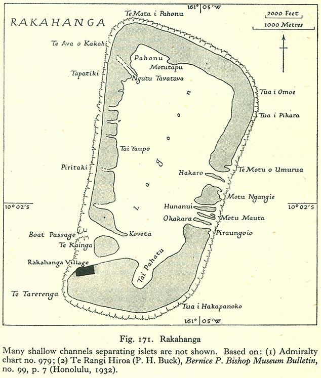
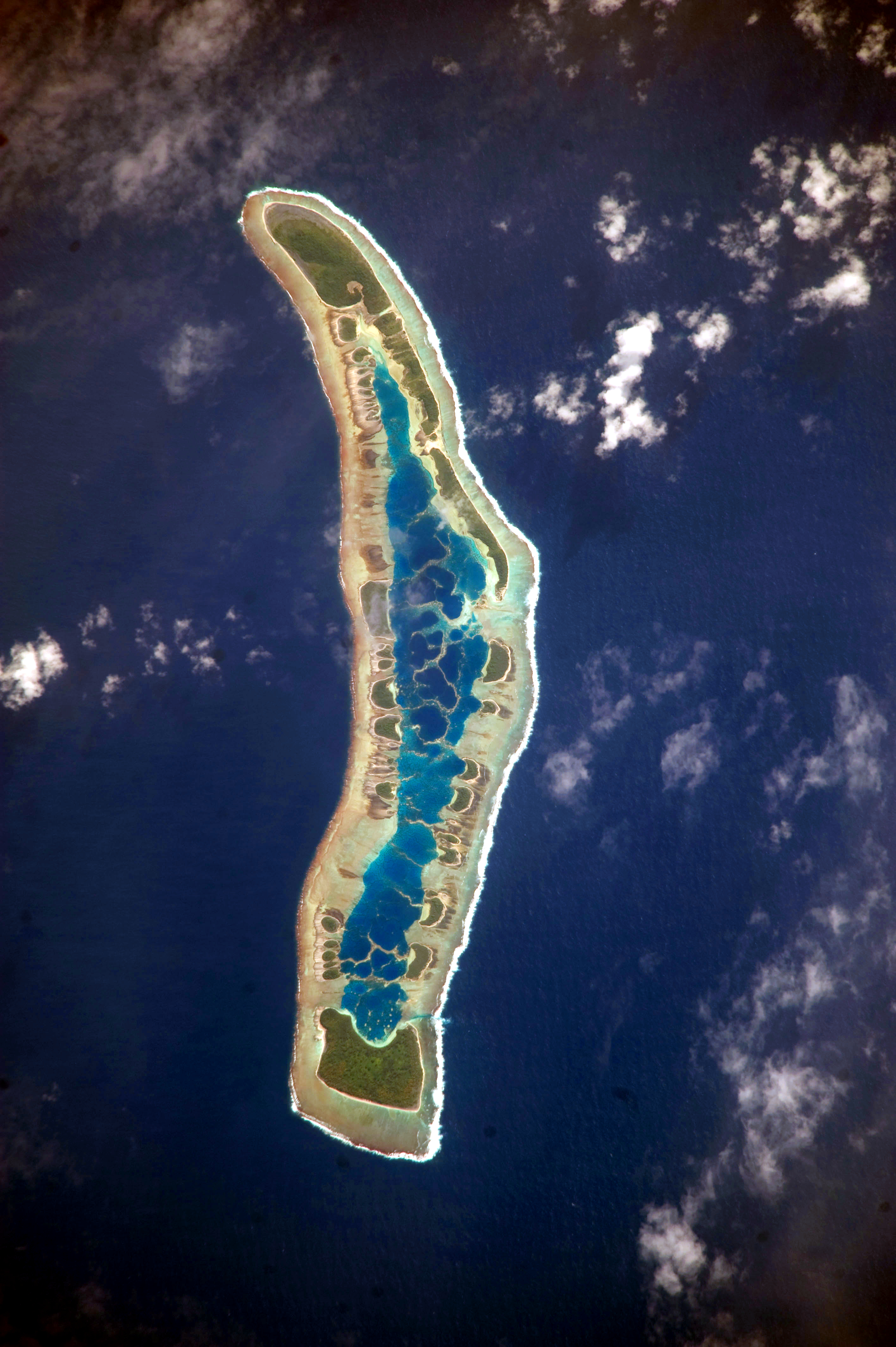
Rakahanga is part of the Cook Islands, situated in the central-southern Pacific Ocean. The unspoilt atoll is from the Cook Islands' capital, Rarotonga, and lies south of the equator. Its nearest neighbour is Manihiki which is just away. Rakahanga's area is . Its highest point is approximately 5 metres above sea level. The population was 83 in the 2016 Census of Population & Dwellings. Since 2014 Rakahanga's power has been 100% solar generated. The Rakahanga-Manihiki language differs from Cook Islands Maori. Geography There are four main islands and seven motus or islets in the Rakahanga lagoon. The northern island is divided into three: Tetukono in the north and northeast, Tetaha Kiraro in the west, and Paerangi in the southwest; while the southern island is Rakahanga. The motus are: on the east, Te Motu o Umurua, Akaro, Motu Ngangie, Huananui, Motu Mahuta and Motu Okakara; while on the southwest side the islet of Te Kainga guards the widest passage into the lagoon. Th ... [...More Info...] [...Related Items...] OR: [Wikipedia] [Google] [Baidu] |
Pukapuka
Pukapuka, formerly Danger Island, is a coral atoll in the northern group of the Cook Islands in the Pacific Ocean. It is one of most remote islands of the Cook Islands, situated about northwest of Rarotonga. On this small island, an ancient culture and distinct language has been maintained over many centuries. The traditional name for the atoll is ''Te Ulu-o-Te-Watu'' ('the head of the stone'), and the northern islet where the people normally reside is affectionately known as Wale ('Home'). Geography Pukapuka is shaped like a three bladed fan. There are three islets on the roughly triangular reef, with a total land area of approximately . Motu Kō, the biggest island is to the southeast; Motu Kotawa (Frigatebird Island) is to the southwest; and the main island Wale is to the north. Kō and Motu Kotawa are uninhabited food reserves, with taro and pulaka gardens and coconut plantations. Pukapuka Airport (ICAO airport code: NCPK) is on Kō. The three villages are located on ... [...More Info...] [...Related Items...] OR: [Wikipedia] [Google] [Baidu] |
Hawaiian Islands
The Hawaiian Islands ( haw, Nā Mokupuni o Hawai‘i) are an archipelago of eight major islands, several atolls, and numerous smaller islets in the North Pacific Ocean, extending some from the island of Hawaii in the south to northernmost Kure Atoll. Formerly the group was known to Europeans and Americans as the Sandwich Islands, a name that James Cook chose in honor of the 4th Earl of Sandwich, the then First Lord of the Admiralty. Cook came across the islands by chance when crossing the Pacific Ocean on his Third Voyage in 1778, on board HMS ''Resolution''; he was later killed on the islands on a return visit. The contemporary name of the islands, dating from the 1840s, is derived from the name of the largest island, Hawaii Island. Hawaii sits on the Pacific Plate and is the only U.S. state that is not geographically connected to North America. It is part of the Polynesia subregion of Oceania. The state of Hawaii occupies the archipelago almost in its entirety (includin ... [...More Info...] [...Related Items...] OR: [Wikipedia] [Google] [Baidu] |
Caroline Island
Caroline Island (also known as Caroline Atoll or Millennium Island) is the easternmost of several uninhabited coral atolls comprising the southern Line Islands in the central Pacific Ocean nation of Kiribati. The atoll was first sighted by Europeans in 1606 and was claimed by the United Kingdom of Great Britain and Ireland in 1868. It has been part of the Republic of Kiribati since the island nation's independence in 1979. Caroline Island has remained relatively untouched and is one of the world's most pristine tropical islands, despite guano mining, copra (coconut meat) harvesting, and human habitation in the 19th and 20th centuries. It is home to one of the world's largest populations of the coconut crab and is an important breeding site for seabirds, most notably the sooty tern. The atoll is known as the first place on Earth to see sunrise each day during much of the year, and for its role in the millennium celebrations of 2000. A 1995 realignment of the International D ... [...More Info...] [...Related Items...] OR: [Wikipedia] [Google] [Baidu] |
Vostok Island
Vostok Island is an uninhabited coral island in the central Pacific Ocean, part of the Line Islands belonging to Kiribati. Other names for the island include Anne Island, Bostock Island, Leavitts Island, Reaper Island, Wostock Island or Wostok Island. The island was first sighted in 1820 by the Russian explorer Fabian Gottlieb von Bellingshausen, who named the island for his ship ''Vostok.'' Geography, flora and fauna Vostok covers a land area of . Its nearest neighbors are Flint Island, south-southeast; Caroline Atoll, to the east; and Penrhyn atoll, Penrhyn, to the west. It is in length, and is triangular-shaped. Beaches on the island range between wide, composed of coral sand and rubble. There is no lagoon or fresh water on the island, and no known freshwater lens. Vostok's major portion is covered with a pure stand of ''Pisonia grandis, Pisonia'' trees rooted in moist peat soil one meter thick. These trees, with heights of up to , grow so densely that no other plan ... [...More Info...] [...Related Items...] OR: [Wikipedia] [Google] [Baidu] |
Starbuck Island
Starbuck Island (or Volunteer Island) is an uninhabited coral island in the central Pacific, and is part of the Central Line Islands of Kiribati. Former names include "Barren Island", "Coral Queen Island", "Hero Island", "Low Island", and "Starve Island". Geography, flora and fauna Located at , just east from the geographic center of the Pacific Ocean (), and measuring east-to-west and north-to-south, Starbuck Island has a land area of . It is a low, dry, coral limestone island with a steep beach backed by a bank composed of large coral fragments. Several hypersaline lagoons form on the island's eastern side. These occasionally dry up, and are said to be dangerous to approach: one worker during the island's guano-mining days sank up to his neck in salty mud before being rescued. There is no freshwater on the island, which is one of the drier atolls in the Line Island group. Annual yearly rainfall averages approximately . Little vegetation exists on Starbuck; stunted ' ... [...More Info...] [...Related Items...] OR: [Wikipedia] [Google] [Baidu] |
Malden Island
Malden Island, sometimes called Independence Island in the 19th century, is a low, arid, uninhabited atoll in the central Pacific Ocean, about in area. It is one of the Line Islands belonging to the Republic of Kiribati. The lagoon is entirely enclosed by land, though it is connected to the sea by underground channels, and is quite salty. The island is chiefly notable for its ancient stone architecture, its once-extensive deposits of phosphatic guano (exploited by Australian interests from 1860–1927), its former use as the site of the first British H-bomb tests (Operation Grapple, 1957), and its current importance as a protected area for breeding seabirds. The island is designated as the ''Malden Island Wildlife Sanctuary''. In 2014 the Kiribati government established a fishing exclusion zone around each of the southern Line Islands ( Caroline (commonly called Millennium), Flint, Vostok, Malden, and Starbuck). Geography Malden Island is located south of the equator, ... [...More Info...] [...Related Items...] OR: [Wikipedia] [Google] [Baidu] |


