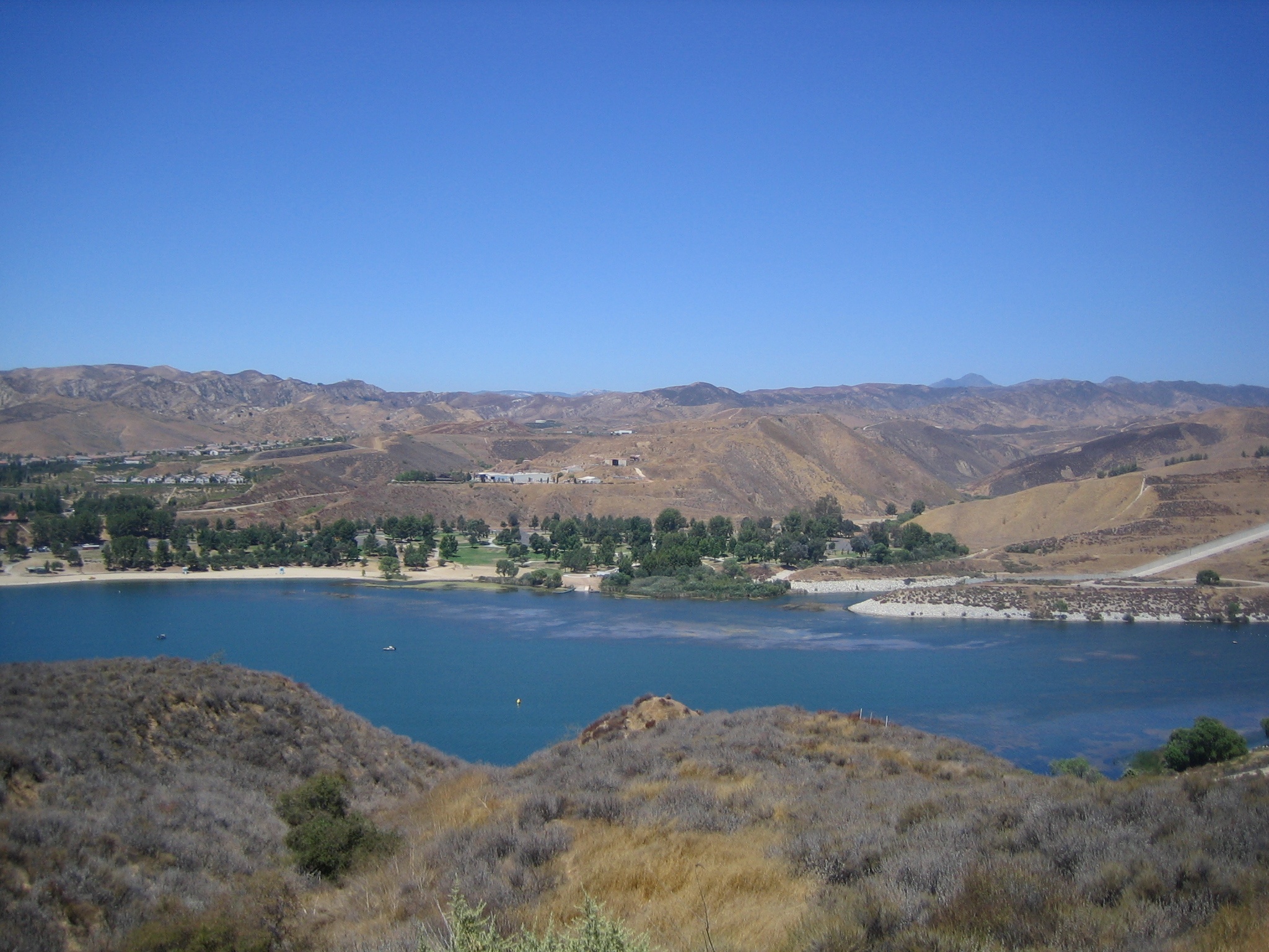
Castaic Lake
   HOME
*


picture info

Castaic Lake
Castaic Lake (Chumash: ''Kaštiq'') is a reservoir formed by Castaic Dam on Castaic Creek, in the Sierra Pelona Mountains of northwestern Los Angeles County, California, United States, near the town of Castaic. The California Office of Environmental Health Hazard Assessment has issued a safety advisory for any fish caught in Castaic Lake and Castaic Lagoon due to elevated levels of mercury and PCBs. Description The lake, with a surface elevation of approximately above sea level, is the terminus of the West Branch California Aqueduct, though some comes from the Castaic Creek watershed above the dam. Castaic Lake is bisected by the Elderberry Forebay Dam, which creates the adjacent Elderberry Forebay. The aqueduct water comes from Pyramid Lake through the Angeles Tunnel and is used to power Castaic Power Plant, a pumped-storage hydroelectric facility on the northern end of the forebay. Water is mostly powering the turbines, rather than being pumped by them. Castaic Lake ...
[...More Info...]      
[...Related Items...]     OR:     [Wikipedia]   [Google]   [Baidu]  


Castaic Dam
Castaic Dam is an embankment dam in northwestern Los Angeles County, California, in the unincorporated area of Castaic. Although located on Castaic Creek, a major tributary of the Santa Clara River, Castaic Creek provides little of its water. The lake is the terminus of the West Branch of the California Aqueduct, part of the State Water Project. The dam was built by the California Department of Water Resources and construction was completed in 1973. The lake has a capacity of and stores drinking water for the western portion of the Greater Los Angeles Area. Dimensions Castaic is an earth-fill dam with its surfaces covered with boulders and cobble-sized rocks to prevent erosion. The dam is high above the streambed, above the foundations, and long, containing of material. The maximum thickness of the base is . Flood waters are released through an ungated, concrete overflow spillway on the west side of the dam, emptying into a stilling basin called Castaic Lagoon (colloquiall ...
[...More Info...]      
[...Related Items...]     OR:     [Wikipedia]   [Google]   [Baidu]  


picture info

Castaic, California
Castaic () (Chumash: ''Kaštiq''; Spanish: ''Castéc'') is an unincorporated community in the northwestern part of Los Angeles County, California. As of the 2010 census it had a population of 19,015. For statistical purposes the Census Bureau has defined Castaic as a census-designated place (CDP). Tens of thousands of motorists pass through Castaic daily as they drive to or from Los Angeles on Interstate 5 (the Golden State Freeway). Castaic Lake is part of the California Water Project and is the site of a hydro-electric power plant. Castaic is northwest of Los Angeles Union Station and northwest of the city of Santa Clarita. The Castaic Range War went on for decades in the late 19th and early 20th centuries resulting in dozens of deaths before hostilities ceased in 1916. Name The name is derived from the Chumash word ''Kaštiq'', meaning "the eye".John R. Johnson, "The Trail to Kashtiq," ''The Journal of California Anthropology,'' vol 5, no 2, pp 188–198SCVHistory.com/ref> ...
[...More Info...]      
[...Related Items...]     OR:     [Wikipedia]   [Google]   [Baidu]  


picture info

Angeles Tunnel
The Angeles Tunnel is a , water tunnel located in the Sierra Pelona Mountains in Los Angeles County, California, about north of Los Angeles."Angeles Tunnel", U.S. Geological Survey.''Pyramid Lake'' 2000, p. 1.American Society 1970, p. 131. It was constructed between 1967 and 1970 as part of the California State Water Project and serves as the final leg of the west branch of the California Aqueduct, which carries Northern California water to Southern California residents.Roach 2008, p. 235. The tunnel also supplies water to the adjacent Castaic Power Plant, a pumped-storage hydroelectricity generation facility.''Castaic Lake'' 2007."South SWP Hydropower", Calif. Dept. of Water Resources. To facilitate power generation, the tunnel's flow is bidirectional. During on-peak energy-demand hours, water flows downhill through the tunnel, starting at an elevation of in Pyramid Lake, and then falling over to the turbines of the Castaic Power Plant at ."Castaic Powerplant", U.S. Geologic ...
[...More Info...]      
[...Related Items...]     OR:     [Wikipedia]   [Google]   [Baidu]  


picture info

The Amazing Race 26
''The Amazing Race 26'' is the twenty-sixth season of the American reality television show ''The Amazing Race''. In this season, eleven teams of dating couples (six existing couples and five blind date teams who met for the first time at the start of the race) competed in a race around the world. The season premiered on CBS with a special 90-minute episode on February 25, 2015, and the season finale aired on May 15, 2015. All three of the final teams were couples matched up as blind dates at the start of the race. Laura Pierson and Tyler Adams were the winners of this season, while Jelani Roy and Jenny Wu finished in second place, and Hayley Keel and Blair Townsend finished in third. Production Development and filming This season covered , five continents, and eight countries, including a first-time visit to Monaco. On some legs, teams could receive special Date Night rewards, which were inserted randomly in clue envelopes. These allowed the lucky team an opportunity to part ...
[...More Info...]      
[...Related Items...]     OR:     [Wikipedia]   [Google]   [Baidu]  


Mighty Morphin Power Rangers
''Mighty Power Rangers'' (''MMPR'') is a superhero television series that premiered on August 28, 1993, on the Fox Kids programming block. It is the first entry of the ''Power Rangers'' franchise, and became a 1990s pop culture phenomenon along with a large line of toys, action figures, and other merchandise. The show adapted stock footage from the Japanese TV series ''Kyōryū Sentai Zyuranger'' (1992–1993), which was the 16th installment of Toei's ''Super Sentai'' franchise. The second and third seasons of the show drew elements and stock footage from ''Gosei Sentai Dairanger'' and ''Ninja Sentai Kakuranger'', respectively, though the ''Zyuranger'' costumes were still used for the lead cast in these two seasons. Only the mecha and the Kiba Ranger (White Ranger) costume from ''Dairanger'' were featured in the second season while only the ''Kakuranger'' mecha was featured in the third season, though the ''Kakuranger'' costumes were later used for the mini-series ''Mighty Morph ...
[...More Info...]      
[...Related Items...]     OR:     [Wikipedia]   [Google]   [Baidu]  


picture info

Santa Clara River (California)
The Santa Clara River ( es, Río Santa Clara) is an longU.S. Geological Survey. National Hydrography Dataset high-resolution flowline dataThe National Map accessed March 16, 2011 river in Southern California. It drains parts of four ranges in the Transverse Ranges System north and northwest of Los Angeles, then flows west onto the Oxnard Plain and into the Santa Barbara Channel of the Pacific Ocean. The watershed has provided habitat for a wide array of native plants and animals and has historically supplied humans with water, fish, and fertile farmland. The northern portion of the watershed was home to the Tataviam people while the southern portion was occupied by the Chumash people. Much of the Santa Clara River Valley is used for agriculture which has limited the use of structural levees to separate the natural floodplain from the river. Although it is one of the least altered rivers in Southern California, some levees exist where the river flows through areas of significant ...
[...More Info...]      
[...Related Items...]     OR:     [Wikipedia]   [Google]   [Baidu]  


picture info

Greater Los Angeles Area
Greater Los Angeles is the second-largest metropolitan region in the United States with a population of 18.5 million in 2021, encompassing five counties in Southern California extending from Ventura County in the west to San Bernardino County and Riverside County in the east, with Los Angeles County in the center and Orange County to the southeast. According to the U.S. Census Bureau, the Los Angeles–Anaheim–Riverside combined statistical area covers , making it the largest metropolitan region in the United States by land area. Of this, the contiguous urban area is , the remainder mostly consisting of mountain and desert areas. In addition to being the nexus of the global entertainment industry (films, television, and recorded music), Greater Los Angeles is also an important center of international trade, education, media, business, tourism, technology, and sports. It is the 3rd largest metropolitan area by nominal GDP in the world with an economy exceeding $1 trillion ...
[...More Info...]      
[...Related Items...]     OR:     [Wikipedia]   [Google]   [Baidu]  


picture info

Interstate 5 In California
Interstate 5 (I-5) is a major north–south route of the Interstate Highway System in the United States, stretching from the Mexican border at the San Ysidro crossing to the Canadian border near Blaine, Washington. The segment of I-5 in California runs across the length of the state from San Ysidro to the Oregon state line south of the Medford- Ashland metropolitan area. It is the longest interstate in California, and accounts for more than half of I-5's total length. It is the more important and most-used of the two major north–south routes on the Pacific Coast, the other being U.S. Route 101 (US 101), which is primarily coastal. I-5 links the major California cities of San Diego, Santa Ana, Los Angeles, Stockton, Sacramento, and Redding. The San Francisco Bay Area is about west of the highway. I-5 is known colloquially as "the 5" to Southern California residents and "5" to Northern California residents due to varieties in California English. I-5 als ...
[...More Info...]      
[...Related Items...]     OR:     [Wikipedia]   [Google]   [Baidu]  


picture info

Angeles National Forest
The Angeles National Forest (ANF) of the United States Forest Service, U.S. Forest Service is located in the San Gabriel Mountains and Sierra Pelona Mountains, primarily within Los Angeles County, California, Los Angeles County in southern California. The ANF manages a majority of the San Gabriel Mountains National Monument. The national forest was established in 1908, incorporating the first San Bernardino National Forest and parts of the former Santa Barbara National Forest, Santa Barbara and San Gabriel National Forests. Angeles National Forest headquarters are located in Arcadia, California. Geography The Angeles National Forest covers a total of , protecting large areas of the San Gabriel Mountains and Sierra Pelona Mountains. It is located just north of the densely inhabited metropolitan area of Greater Los Angeles Area, Greater Los Angeles. While primarily within Los Angeles County, a small part extends eastward into southwestern San Bernardino County, California, San Be ...
[...More Info...]      
[...Related Items...]     OR:     [Wikipedia]   [Google]   [Baidu]  


California Department Of Parks And Recreation
The California Department of Parks and Recreation, more commonly known as California State Parks, manages the California state parks system. The system administers 279 separate park units on 1.4 million acres (570,000 hectares), with over 280 miles (450 km) of coastline; 625 miles (1,000 km) of lake and river frontage; nearly 15,000 campsites; and 3,000 miles (4,800 km) of hiking, biking, and equestrian trails. Headquartered in Sacramento, park administration is divided into 21 districts. The California State Parks system is the largest state park system in the United States. History California's first state park was the Yosemite Grant, which today constitutes part of Yosemite National Park. In 1864, the federal government set aside Yosemite Valley for preservation and ceded the land to the state, which managed the famous glacial valley until 1906. California's oldest state park, Big Basin Redwoods State Park, was founded in 1902. Until 1921, each park was mana ...
[...More Info...]      
[...Related Items...]     OR:     [Wikipedia]   [Google]   [Baidu]  


picture info

Santa Clarita, California
Santa Clarita (; Spanish for "Little St. Clare") is a city in northwestern Los Angeles County in the U.S. state of California. With a 2020 census population of 228,673, it is the third-largest city by population in Los Angeles County, the 17th-largest in California, and the 99th-largest city in the United States. It is located about northwest of downtown Los Angeles, and occupies of land in the Santa Clarita Valley, along the Santa Clara River. It is a notable example of a U.S. edge city, satellite city, or boomburb. Human settlement of the Santa Clarita Valley dates back to the arrival of the Chumash people, who were displaced by the Tataviam circa 450 AD. After Spanish colonists arrived in Alta California, the Rancho San Francisco was established, covering much of the Santa Clarita Valley. Henry Mayo Newhall purchased the Rancho San Francisco in 1875 and established the towns of Saugus and Newhall. The Newhall Land and Farming Company played a major role in the city's de ...
[...More Info...]      
[...Related Items...]     OR:     [Wikipedia]   [Google]   [Baidu]  


picture info

State Park
State parks are parks or other protected areas managed at the sub-national level within those nations which use "state" as a political subdivision. State parks are typically established by a state to preserve a location on account of its natural beauty, historic interest, or recreational potential. There are state parks under the administration of the government of each U.S. state, some of the political divisions of Mexico#States, Mexican states, and in Brazil. The term is also used in the Australian states of template:state parks of Victoria, Victoria and state parks of New South Wales, New South Wales. The equivalent term used in Canada, Argentina, South Africa, and Belgium, is provincial park. Similar systems of local government maintained parks exist in other countries, but the terminology varies. State parks are thus similar to national parks, but under state rather than federal administration. Similarly, local government entities below state level may maintain parks, e.g., r ...
[...More Info...]      
[...Related Items...]     OR:     [Wikipedia]   [Google]   [Baidu]