|
Cape Wickham
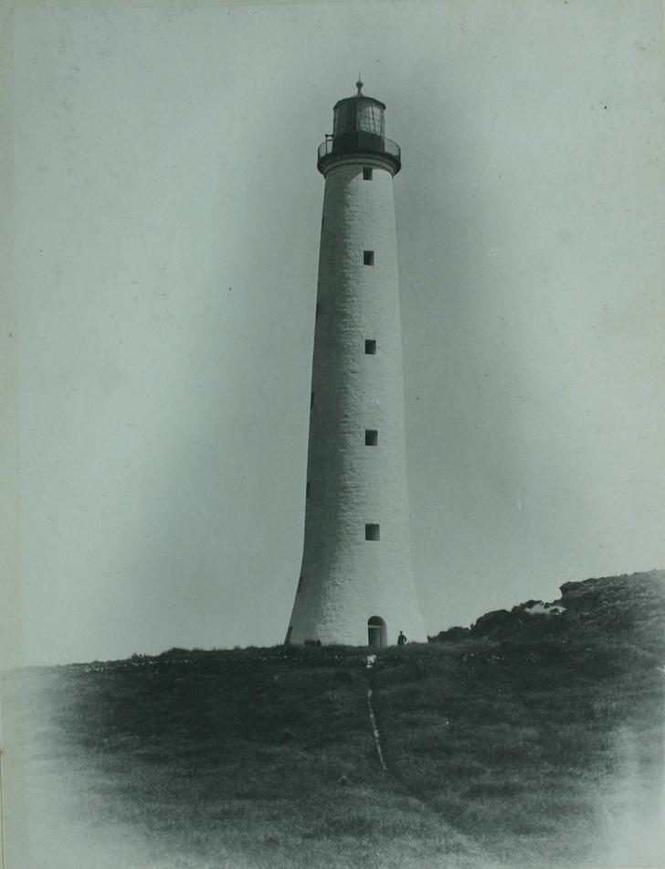
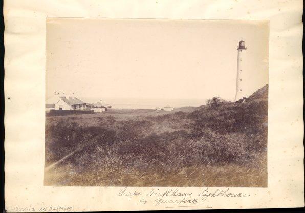
Cape Wickham is the most northerly point of King Island, Tasmania, Australia. From here, it is to Cape Otway on the Australian mainland. In the 19th century, ships coming from Europe would sometimes attempt to sail between Cape Wickham and Cape Otway to cut down on the required travelling time to Sydney, however the trip was dangerous and the price of failure high; usually shipwreck on the unforgiving King Island coast. The Cape Wickham lighthouse The Cape Wickham Lighthouse is a lighthouse situated at Cape Wickham on King Island, Tasmania. At tall, it is Australia's tallest lighthouse. The lighthouse is listed on the Commonwealth Heritage Register. There are eleven timber flights o ... situated on the cape had its 150th anniversary in 2011 The lighthouse was constructed in the 1860s when the island was still known as ''King's Island''. On 30 October 2015, Cape Wickham Links, and 18-hole golf course, opened to the public. See also *Cape Wickham Lighthouse Reference ... [...More Info...] [...Related Items...] OR: [Wikipedia] [Google] [Baidu] |
Cape (geography)
In geography, a cape is a headland or a promontory of large size extending into a body of water, usually the sea.Whittow, John (1984). ''Dictionary of Physical Geography''. London: Penguin, 1984, p. 80. . A cape usually represents a marked change in trend of the Coast, coastline, often making them important landmarks in sea navigation. This also makes them prone to natural forms of erosion, mainly tidal actions, which results in them having a relatively short geological lifespan. Capes can be formed by glaciers, volcanoes, and changes in sea level. Erosion plays a large role in each of these methods of formation. List of some well-known capes Gallery File:Cape Cornwall.jpg, Cape Cornwall, England File:Nasa photo cape fear.jpg, Satellite image of Cape Fear, North Carolina File:Cape McLear, Malawi (2499273862).jpg, Cape MacLear, Malawi File:Cape horn.png, Map depicting Cape Horn at the southernmost portion of South America File:Spain.Santander.Cabo.Mayor.jpeg, Photograph o ... [...More Info...] [...Related Items...] OR: [Wikipedia] [Google] [Baidu] |
King Island (Tasmania)
King Island is an island in the Bass Strait, belonging to the Australian state of Tasmania. It is the largest of three islands known as the New Year Group, and the second-largest island in Bass Strait (after Flinders Island). The island's population at the was 1,585 people, up from 1,566 in 2011. The local government area of the island is the King Island Council. The island forms part of the official land divide between the Great Australian Bight and Bass Strait, off the north-western tip of Tasmania and about halfway to the mainland state of Victoria. The southernmost point is Stokes Point and the northernmost point is Cape Wickham. There are three small islands immediately offshore: New Year Island and Christmas Island situated to the northwest, and a smaller island Councillor Island to the east, opposite Sea Elephant Beach. King Island was first visited by Europeans in the late 18th century. It was named after Philip Gidley King, Colonial Governor of New South Wales, who ... [...More Info...] [...Related Items...] OR: [Wikipedia] [Google] [Baidu] |
Tasmania
) , nickname = , image_map = Tasmania in Australia.svg , map_caption = Location of Tasmania in AustraliaCoordinates: , subdivision_type = Country , subdivision_name = Australia , established_title = Before federation , established_date = Colony of Tasmania , established_title2 = Federation , established_date2 = 1 January 1901 , named_for = Abel Tasman , demonym = , capital = Hobart , largest_city = capital , coordinates = , admin_center = 29 local government areas , admin_center_type = Administration , leader_title1 = Monarch , leader_name1 = Charles III , leader_title2 = Governor , leader_name2 ... [...More Info...] [...Related Items...] OR: [Wikipedia] [Google] [Baidu] |
Australia
Australia, officially the Commonwealth of Australia, is a Sovereign state, sovereign country comprising the mainland of the Australia (continent), Australian continent, the island of Tasmania, and numerous List of islands of Australia, smaller islands. With an area of , Australia is the largest country by area in Oceania and the world's List of countries and dependencies by area, sixth-largest country. Australia is the oldest, flattest, and driest inhabited continent, with the least fertile soils. It is a Megadiverse countries, megadiverse country, and its size gives it a wide variety of landscapes and climates, with Deserts of Australia, deserts in the centre, tropical Forests of Australia, rainforests in the north-east, and List of mountains in Australia, mountain ranges in the south-east. The ancestors of Aboriginal Australians began arriving from south east Asia approximately Early human migrations#Nearby Oceania, 65,000 years ago, during the Last Glacial Period, last i ... [...More Info...] [...Related Items...] OR: [Wikipedia] [Google] [Baidu] |
Cape Otway
Cape Otway is a cape and a bounded locality of the Colac Otway Shire in southern Victoria, Australia on the Great Ocean Road; much of the area is enclosed in the Great Otway National Park. History Cape Otway was originally inhabited by the Gadubanud people; evidence of their campsites is contained in the middens throughout the region. The traditional Gadubanud name for the cape is ''Bangurac''. The cape was charted by the British when Lieutenant James Grant sailed through Bass Strait in in December 1800. Grant named it Cape Albany Otway after Captain William Albany Otway. This was later shortened to Cape Otway. The British started to colonise the region in 1837 when Joseph Gellibrand and George Hesse became lost in the Otways on an expedition. It was found that Hesse probably died of exposure, while Gellibrand was initially cared for by a local Aboriginal clan but later killed by members of another clan visiting from the Apollo Bay area. The ship ''Joanna'' was wrecked near t ... [...More Info...] [...Related Items...] OR: [Wikipedia] [Google] [Baidu] |
Sydney
Sydney ( ) is the capital city of the state of New South Wales, and the most populous city in both Australia and Oceania. Located on Australia's east coast, the metropolis surrounds Sydney Harbour and extends about towards the Blue Mountains to the west, Hawkesbury to the north, the Royal National Park to the south and Macarthur to the south-west. Sydney is made up of 658 suburbs, spread across 33 local government areas. Residents of the city are known as "Sydneysiders". The 2021 census recorded the population of Greater Sydney as 5,231,150, meaning the city is home to approximately 66% of the state's population. Estimated resident population, 30 June 2017. Nicknames of the city include the 'Emerald City' and the 'Harbour City'. Aboriginal Australians have inhabited the Greater Sydney region for at least 30,000 years, and Aboriginal engravings and cultural sites are common throughout Greater Sydney. The traditional custodians of the land on which modern Sydney stands are ... [...More Info...] [...Related Items...] OR: [Wikipedia] [Google] [Baidu] |
Cape Wickham Lighthouse
The Cape Wickham Lighthouse is a lighthouse situated at Cape Wickham on King Island, Tasmania. At tall, it is Australia's tallest lighthouse. The lighthouse is listed on the Commonwealth Heritage Register. There are eleven timber flights of stairs in the lighthouse, with twenty steps each, which must be climbed in order to reach the top. Surrounding the lighthouse are the remains of a number of associated buildings, including a small church. There are also a number of gravestones, many belonging to those who were shipwrecked in the area after the lighthouse was built. History The lighthouse was originally established in 1861, in response to the sinking of the barque '' Cataraqui'' sixteen years earlier, a disaster which had resulted in the deaths of 400 people. While it was being constructed, some worried that the lighthouse would cause more shipwrecks than it prevented, as lighthouses usually showed the way to safety rather than warning of danger as the Cape Wickham li ... [...More Info...] [...Related Items...] OR: [Wikipedia] [Google] [Baidu] |
Australian Maritime Safety Authority
Australian Maritime Safety Authority (AMSA) is an Australian statutory authority responsible for the regulation and safety oversight of Australia's shipping fleet and management of Australia's international maritime obligations. The authority has jurisdiction over Australia's exclusive economic zone which covers an area of . AMSA maintains Australia's shipping registries: the generalAMSARegister a vessel/ref> and the international shipping registers.AMSAAustralian international shipping register/ref> AMSA was established in 1990 under the ''Australian Maritime Safety Authority Act 1990'' and governed by the ''Commonwealth Authorities and Companies Act 1997''. AMSA is an agency within the Department of Infrastructure and Transport. Directors are appointed by the minister. The international treaties which AMSA administers include the ''Navigation Act 2012'' and the ''Protection of the Sea (Prevention of Pollution from Ships) Act 1983''. Organised sea rescue in Australia was ... [...More Info...] [...Related Items...] OR: [Wikipedia] [Google] [Baidu] |
1842 - 1899)
__NOTOC__ Year 184 ( CLXXXIV) was a leap year starting on Wednesday (link will display the full calendar) of the Julian calendar. At the time, it was known as the Year of the Consulship of Eggius and Aelianus (or, less frequently, year 937 ''Ab urbe condita''). The denomination 184 for this year has been used since the early medieval period, when the Anno Domini calendar era became the prevalent method in Europe for naming years. Events By place China * The Yellow Turban Rebellion and Liang Province Rebellion break out in China. * The Disasters of the Partisan Prohibitions ends. * Zhang Jue leads the peasant revolt against Emperor Ling of Han of the Eastern Han Dynasty. Heading for the capital of Luoyang, his massive and undisciplined army (360,000 men), burns and destroys government offices and outposts. * June – Ling of Han places his brother-in-law, He Jin, in command of the imperial army and sends them to attack the Yellow Turban rebels. * Winter – Zha ... [...More Info...] [...Related Items...] OR: [Wikipedia] [Google] [Baidu] |
Cape Wickham Links
Cape Wickham Links is an 18-hole golf course that was constructed on the northern tip of King Island, north of Currie, on Tasmania. It opened to the public on 30 October 2015. A par 72 course, it is long. Critically acclaimed, it has been ranked third in the Australian ''Golf Digest'' Top 100 Courses rankings, and 24th in the world. History Andrew Purchase bought the land in 2011. Extra land was required, which resulted in Victorian course owner Duncan Andrews investing in the project, and the Tasmanian Government making some public land available for lease. Golf course designer Mike De Vries designed the course, nine holes of which straddle the coastline. The windy climate necessitated the use of multiple types of fescue grasses for the greens. The course has cost $8 million to buy and construct. Covering around , the course encroached on the nesting burrows of short-tailed shearwaters. Some of these were destroyed in the course's creation, however, the construction took place ... [...More Info...] [...Related Items...] OR: [Wikipedia] [Google] [Baidu] |


