|
Cape Town Railway Station
Cape Town railway station is the main railway station of the city of Cape Town, South Africa. It is located along Adderley and Strand Streets in the city's central business district. Lines Metrorail lines Cape Town station is the hub of the Metrorail Western Cape commuter rail network, which is operated by the Metrorail division of the Passenger Rail Agency of South Africa (PRASA). The network consists of four lines, all of which originate from Cape Town: the Southern Line via the Southern Suburbs to Simon's Town; the Cape Flats Line via Athlone to Retreat; the Central Line via Langa to Mitchell's Plain, Khayelitsha and Bellville; and the Northern Line via Bellville to Paarl, Stellenbosch and Somerset West. Shosholoza Meyl Shosholoza Meyl, the inter-city rail division of PRASA, operates several long-distance passenger rail services from Cape Town: a daily service to and from Johannesburg via Kimberley; a weekly service to and from Durban via Kimberley, Bloemfontein an ... [...More Info...] [...Related Items...] OR: [Wikipedia] [Google] [Baidu] |
Cape Town
Cape Town ( af, Kaapstad; , xh, iKapa) is one of South Africa's three capital cities, serving as the seat of the Parliament of South Africa. It is the legislative capital of the country, the oldest city in the country, and the second largest (after Johannesburg). Colloquially named the ''Mother City'', it is the largest city of the Western Cape province, and is managed by the City of Cape Town metropolitan municipality. The other two capitals are Pretoria, the executive capital, located in Gauteng, where the Presidency is based, and Bloemfontein, the judicial capital in the Free State, where the Supreme Court of Appeal is located. Cape Town is ranked as a Beta world city by the Globalization and World Cities Research Network. The city is known for its harbour, for its natural setting in the Cape Floristic Region, and for landmarks such as Table Mountain and Cape Point. Cape Town is home to 66% of the Western Cape's population. In 2014, Cape Town was named the best place ... [...More Info...] [...Related Items...] OR: [Wikipedia] [Google] [Baidu] |
Southern Line (Cape Town)
The Southern Line is a commuter rail line operated by Metrorail Western Cape, connecting Cape Town station in central Cape Town, South Africa with the Southern Suburbs and the towns on the west coast of False Bay, terminating in Simon's Town. History The Wynberg Railway Company was established in 1861 to build a railway line from Salt River Junction to Wynberg, which opened on 19 December 1864. In 1876 the company was taken over by the Cape Government Railways, and the line, which had originally been built to the standard gauge, was rebuilt to Cape gauge. The extension to Muizenberg opened on 15 December 1882, and a further extension to Kalk Bay on 5 May 1883. The final extension, to the naval base at Simon's Town, opened on 1 December 1890. The line was electrified with overhead catenary in 1928. Operation The line runs on "Cape gauge" track, and is electrified with 3,000 V DC overhead catenary. Service on the line is provided by Electric Multiple Units of Class 5M2A and ... [...More Info...] [...Related Items...] OR: [Wikipedia] [Google] [Baidu] |
Stellenbosch
Stellenbosch (; )A Universal Pronouncing Gazetteer. Thomas Baldwin, 1852. Philadelphia: Lippincott, Grambo & Co.A Grammar of Afrikaans. Bruce C. Donaldson. 1993. Berlin: Walter de Gruyter. is a town in the Western Cape province of South Africa, situated about east of Cape Town, along the banks of the Eerste River at the foot of the Stellenbosch Mountain. The town became known as the City of Oaks or ''Eikestad'' in Afrikaans and Dutch language, Dutch due to the large number of oak trees that were planted by its founder, Simon van der S ... [...More Info...] [...Related Items...] OR: [Wikipedia] [Google] [Baidu] |
Paarl
Paarl (; Afrikaans: ; derived from ''Parel'', meaning "pearl" in Dutch) is a town with 112,045 inhabitants in the Western Cape province of South Africa. It is the third-oldest city and European settlement in the Republic of South Africa (after Cape Town and Stellenbosch) and the largest town in the Cape Winelands. Due to the growth of the Mbekweni township, it is now a de facto urban unit with Wellington. It is situated about northeast of Cape Town in the Western Cape Province and is known for its scenic environment and viticulture and fruit-growing heritage. Paarl is the seat of the Drakenstein Local Municipality; although not part of the Cape Town metropolitan area, it falls within its economic catchment. Paarl is unusual among South African place-names, in being pronounced differently in English than in Afrikaans; likewise unusual about the town's name is Afrikaners customary attachment to it, saying not ''in Paarl'', but rather ''in die Paarl'', or ''in die Pêrel'' (lite ... [...More Info...] [...Related Items...] OR: [Wikipedia] [Google] [Baidu] |
Northern Line (Cape Town)
The Northern Line is a commuter rail service in South Africa that in the Cape Town metropolitan area and its surroundings and is operated by Metrorail Western Cape. Northern Line services operate from central Cape Town to Bellville, Cape Town, Bellville, and then from Bellville along three different routes. The first route runs along the main Cape Town–De Aar railway line to Paarl and Wellington, Western Cape, Wellington. The second route passes through Stellenbosch to terminate at Muldersvlei railway station, Muldersvlei station on the main line, while the third also passes through Somerset West to terminate in Strand, Western Cape, Strand. Since March 2020 most of this line has not been operated. Maintenance has not been carried out and parts of the line are stolen or vandalised and not replaced. Communication by the operator is scarce, but when given often overly optimistic on its ability to return the service to its former shape. For all intends and purposes - this line ... [...More Info...] [...Related Items...] OR: [Wikipedia] [Google] [Baidu] |
Bellville, Cape Town
Bellville is a town in the Western Cape province of South Africa. It is situated adjacent to the Koelberg Mountains and also the University of Western Cape where it has its own campus. Established It was founded as "12 Mile Post" (Afrikaans: "12-Myl-Pos") because it is located 12 miles (20 km) from Cape Town city centre. It was first known as "Hardekraaltjie". Founded as a Bellville railway station, railway station on the line from Cape Town to Stellenbosch and Strand, Western Cape, Strand, it was renamed Bellville in 1861 after the surveyor-general Charles Davidson Bell, Charles Bell. The motor registration number bears the number CY. Hospitals and educational institutes The Karl Bremer Hospital functioned as the Academic Hospital for the University of Stellenbosch Medical School, but now the adjacent Tygerberg Hospital houses the medical school. Other hospitals in Bellville are: Mediclinic International Louis Leipoldt and Melomed. The Cape Peninsula University of ... [...More Info...] [...Related Items...] OR: [Wikipedia] [Google] [Baidu] |
Khayelitsha
Khayelitsha () is a township in Western Cape, South Africa, on the Cape Flats in the City of Cape Town Metropolitan Municipality. The name is Xhosa for ''New Home''. It is reputed to be the largestNew, Assertive Women's Voices in Local Election by Erna Curry, 29 January 2011 and fastest-growing township in South Africa. History initially opposed implementing the passed in 1950, and residential areas in the city remained unsegregated until the first Group Areas were declared in the city in 1957.[...More Info...] [...Related Items...] OR: [Wikipedia] [Google] [Baidu] |
Mitchell's Plain
Mitchells Plain is a large township located within the City of Cape Town, Western Cape, South Africa and situated about from the Cape Town city centre. It is one of South Africa's largest residential areas and contains multiple smaller suburbs. It is located on the Cape Flats on the False Bay coast between Muizenberg and Khayelitsha. Conceived of as a "model suburb" by the apartheid government, it was built during the 1970s to provide housing for Coloured victims of forced removal due to the implementation of the Group Areas Act. At an estimated population of 290,000–305,000 people, it comprises a number of sub-sections which reflect the diverse class backgrounds of the population. It was once a major stronghold of the United Democratic Front, the broad-based ANC-sponsored anti-apartheid body. It also has one of greater Cape Town's biggest shopping centres, known as the Liberty Promenade. History Mitchells Plain was created by the apartheid government in the early 1970s a ... [...More Info...] [...Related Items...] OR: [Wikipedia] [Google] [Baidu] |
Langa, Cape Town
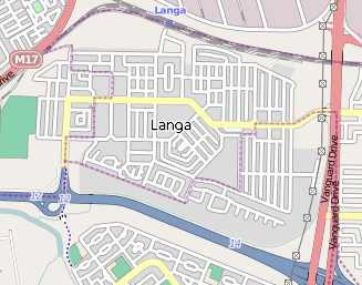
Langa is a township in Cape Town, South Africa. Its name in Xhosa means "sun". The township was initially built in phases before being formally opened in 1927. It was developed as a result of South Africa's 1923 Urban Areas Act (more commonly known as the "pass laws"), which was designed to force Africans to move from their homes into segregated locations. Similar to Nyanga, Langa is one of the many areas in South Africa that were designated for Black Africans before the apartheid era. It is the oldest of such suburbs in Cape Town and was the location of much resistance to apartheid. Langa is also where several people were killed on 21 March 1960, the same day as the Sharpeville massacre, during the anti-pass campaign. On 21 March 2010, now 50 years later, a monument was unveiled by the government in remembrance of the people who died while on the protest march. Location Langa is bordered by the M17 (Jan Smuts Drive) to the west, the N2 to the south, and the M7 to the east ... [...More Info...] [...Related Items...] OR: [Wikipedia] [Google] [Baidu] |
Central Line (Cape Town)
The Central Line is a commuter rail service in Cape Town, South Africa, operated by Metrorail Western Cape. Central Line services operate along two routes from central Cape Town to Langa, and then along three branches from Langa to various areas in the south-east of the city. The first branch runs to Mitchell's Plain, the second to Khayelitsha, and the third passes through Belhar to terminate in Bellville. Route Central Line trains depart from Cape Town station on one of two routes. The first route runs along the original Cape Town–Bellville main line through Salt River to Maitland, and then branches south to pass around the western and southern edge of Pinelands to Langa station. The other route runs along the relief main line past Paarden Eiland and then branches south through Kensington to Mutual station; from Mutual it runs along the eastern edge of Pinelands to Langa. From Langa station all trains pass through Bonteheuwel station; some continue east through B ... [...More Info...] [...Related Items...] OR: [Wikipedia] [Google] [Baidu] |
Retreat, Cape Town
Retreat is a suburb in Cape Town, South Africa. Geography Retreat is bordered by Steenberg and Lavender Hill to the south, Tokai, Bergvliet and Kirstenhof to the West and Heathfield to the north. Retreat railway station is on the main line from Cape Town to Simon's Town. Main Road (which runs from Central Cape Town through to Simon's Town) runs along the west of Retreat. History The suburb of Retreat in Cape Town was so named because the Dutch retreated to that area when they were losing the Battle of Muizenberg The Invasion of the Cape Colony, also known as the Battle of Muizenberg, was a British military expedition launched in 1795 against the Dutch Cape Colony at the Cape of Good Hope. The Dutch colony at the Cape, established and controlled by th .... The Dutch landed there after the Retreat and declared the area to be 'Terugtrekking van de nederlandse 1795' or in English, Retreat of the Netherlands 1795. The signage with 'Terugtrekking van de nederlandse 1795' writt ... [...More Info...] [...Related Items...] OR: [Wikipedia] [Google] [Baidu] |
Athlone, Cape Town
Athlone is a suburb of Cape Town located to the east of the city centre on the Cape Flats, south of the N2 highway. Two of the suburb's main landmarks are Athlone Stadium and the decommissioned coal-burning Athlone Power Station. Athlone is mainly residential and is served by a railway station of the same name. It however includes industrial (Athlone Industria 1 & 2) and commercial zones (Athlone CBD and Gatesville). There are many "sub-areas" within Athlone, including Gatesville, Rylands, Belgravia Estate, Bridgetown and Hazendal. Colloquially other areas around Athlone are also often included in the greater Athlone area even though the City of Cape Town might classify them as separate neighborhoods such as Rondebosch East, Crawford, and Manenberg. History Originally known as West London the area was renamed Athlone after Alexander Cambridge, 1st Earl of Athlone who was Governor-General of the Union of South Africa from 1924 to 1930. During Apartheid the area was designated ... [...More Info...] [...Related Items...] OR: [Wikipedia] [Google] [Baidu] |


.jpg)


.jpg)