|
Campamento (San Roque)
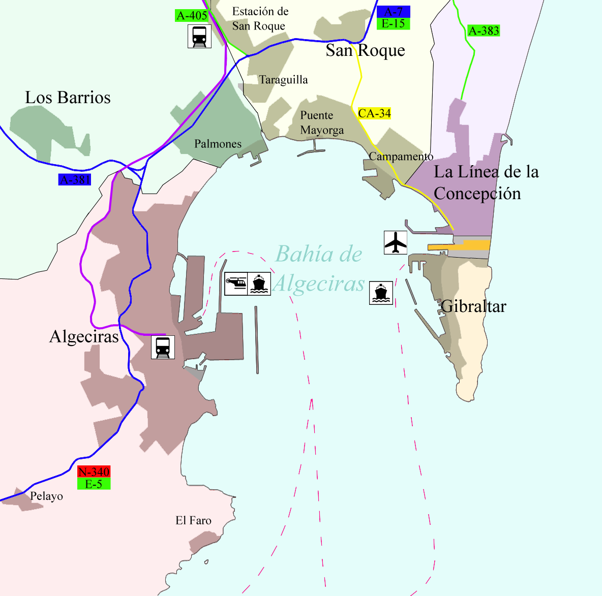
Campamento is a coastal village and district of the municipality of San Roque of the Province of Cádiz, Andalucia, Spain. Although it belongs administratively to San Roque, it is four kilometres south of the centre and is located on the Bay of Algeciras, to the northwest of Gibraltar, and is effectively a northwestern suburb of La Línea de la Concepción. As of 2011 it had 1836 inhabitants. Campamento lies along the motorway Autovía CA-34. The highway CA-2321 links with Guadarranque. A regular bus runs between Campamento and the towns of San Roque and La Línea de la Concepción. History This neighborhood is named after Spanish troops setting up camp during the Great Siege of Gibraltar. In the seventeenth century the cortijo A ''cortijo'' is a type of traditional rural dwelling (akin to the German ''Bauernhof'', also known as a Farmhouse in English) in the southern half of Spain, including all of Andalusia and parts of Extremadura and Castile-La Mancha.Antonio Alc ... [...More Info...] [...Related Items...] OR: [Wikipedia] [Google] [Baidu] |
Province Of Cádiz
Cádiz is a Provinces of Spain, province of southern Spain, in the southwestern part of the Autonomous communities of Spain, autonomous community of Andalusia. It is the southernmost part of mainland Spain, as well as the southernmost part of continental Europe. It is bordered by the Spanish provinces of Province of Huelva, Huelva, Province of Seville, Seville, and Province of Málaga, Málaga, as well as the Atlantic Ocean, the Mediterranean Sea, the Strait of Gibraltar and the British overseas territory of Gibraltar. Its area is . Its Capital city, capital is the city of Cádiz, which has a population of 114,244. As of 2021, the largest city is Jerez de la Frontera with 212,801 inhabitants. Algeciras, which surpassed Cádiz with 122,982 inhabitants is the second most populated city. The entire province had a population of 1,245,960 (as of 2021), of whom about 600,000 live in the Bay of Cádiz (comarca), Bay of Cádiz area (including Jerez), making it the third most populous provi ... [...More Info...] [...Related Items...] OR: [Wikipedia] [Google] [Baidu] |
List Of Postal Codes In Spain
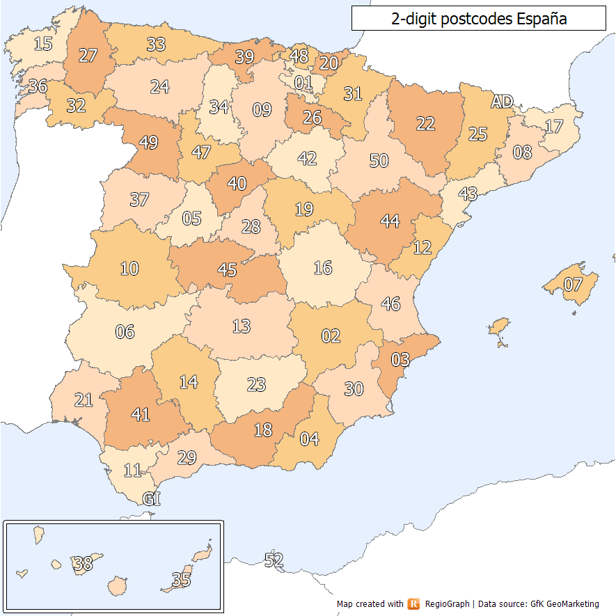
Spanish postal codes were introduced on 1 July 1984, when the introduced automated mail sorting. They consist of five numerical digits, where the first two digits, ranging 01 to 52, correspond either to one of the 50 provinces of Spain or to one of the two autonomous cities on the African coast. Two-digit prefixes The first two digits of a Spanish postal code identify the province or autonomous city it belongs to. The numbers were assigned to the 50 provinces of Spain ordered alphabetically at the time of implementation. The official names of some of the provinces have since changed, either to the regional language version of the name (e.g. from the Spanish to the Basque ) or to adopt the name of the autonomous community instead of the provincial capital (e.g. Santander to Cantabria). In these cases, the originally assigned code has been maintained, resulting in some exceptions to the alphabetical order. In addition, Ceuta and Melilla were originally included within the ... [...More Info...] [...Related Items...] OR: [Wikipedia] [Google] [Baidu] |
Cortijo
A ''cortijo'' is a type of traditional rural dwelling (akin to the German ''Bauernhof'', also known as a Farmhouse in English) in the southern half of Spain, including all of Andalusia and parts of Extremadura and Castile-La Mancha.Antonio Alcalá Venceslada, ''Vocabulario Andaluz'', El Mundo-Unidad Editorial, Barcelona 1999, p. 173 ''Cortijos'' may have their origins in ancient Roman villas, for the word is derived from the Latin ''cohorticulum'', a diminutive of ''cohors'', meaning 'courtyard' or inner enclosure. They are often isolated structures associated with a large family farming or livestock operation in the vast and empty adjoining lands. Description A ''cortijo'' would usually include a large house, together with accessory buildings such as workers' quarters, sheds to house livestock, granaries, oil mills, barns and often a wall limiting the enclosure where there were no buildings surrounding it.Antonio López Ontiveros et al. ''Geografía de Andalucía'', Ed. Arie ... [...More Info...] [...Related Items...] OR: [Wikipedia] [Google] [Baidu] |
Great Siege Of Gibraltar
The Great Siege of Gibraltar was an unsuccessful attempt by Spain and France to capture Gibraltar from the British during the War of the American Revolution. It was the largest battle in the war by number of combatants. The American war had ended with the British defeat at Yorktown in October 1781, but the Bourbon defeat in their great final assault on Gibraltar would not come until September 1782. The siege was suspended in February 1783 at the beginning of peace talks with the British. On 16 June 1779, Spain entered the war on the side of France and as co-belligerents of the revolutionary United Colonies—the British base at Gibraltar was Spain's primary war aim. The vulnerable Gibraltar garrison under George Augustus Eliott was blockaded from June 1779 to February 1783, initially by the Spanish alone, led by Martín Álvarez de Sotomayor. The blockade proved to be a failure because two relief convoys entered unmolested—the first under Admiral George Rodney in 1780 and th ... [...More Info...] [...Related Items...] OR: [Wikipedia] [Google] [Baidu] |
Autovía CA-34
The Autovía CA-34 is an autovía in the province of Cádiz, Andalusia, Spain, providing a link between the Autovía A-7 and Gibraltar. It runs for 3 km (2 miles) between the A-7 at San Roque and the village of Campamento. Thereafter, it continues for a further 4 km (2.5 miles) as a national road, the N-351, through Campamento and along the west side of La Línea de la Concepción La Línea de la Concepción (, more often referred to as La Línea) is a municipality of Spain belonging to the province of Cádiz, Andalusia. The city lies on the sandy isthmus which is part of the eastern flank of the Bay of Gibraltar, an ... to the checkpoint at the border with Gibraltar. Once pass checkpoint vehicles enter Gibraltar onto Winston Churchill Avenue. {{DEFAULTSORT:Autovia CA-34 Autopistas and autovías in Spain Transport in Andalusia ... [...More Info...] [...Related Items...] OR: [Wikipedia] [Google] [Baidu] |
La Línea De La Concepción
La Línea de la Concepción (, more often referred to as La Línea) is a municipality of Spain belonging to the province of Cádiz, Andalusia. The city lies on the sandy isthmus which is part of the eastern flank of the Bay of Gibraltar, and it limits with the Gibraltar–Spain border to the south. La Línea has close economic and social links with the British overseas territory of Gibraltar. The first dwellings, which date back to the 18th century, were behind the Spanish lines, being part of the municipality of San Roque until 1870, when La Línea became a standalone municipality. The people of La Línea have traditionally found work in Gibraltar, from the days in the 18th century when Gibraltar was an important naval port. This stopped with the total closure of the border by the Spanish government between 9 June 1969 and 15 December 1982 as a result of the dispute between Spain and Britain regarding the sovereignty of Gibraltar. The border was fully reopened on 5 Febr ... [...More Info...] [...Related Items...] OR: [Wikipedia] [Google] [Baidu] |
Gibraltar
) , anthem = " God Save the King" , song = " Gibraltar Anthem" , image_map = Gibraltar location in Europe.svg , map_alt = Location of Gibraltar in Europe , map_caption = United Kingdom shown in pale green , mapsize = , image_map2 = Gibraltar map-en-edit2.svg , map_alt2 = Map of Gibraltar , map_caption2 = Map of Gibraltar , mapsize2 = , subdivision_type = Sovereign state , subdivision_name = , established_title = British capture , established_date = 4 August 1704 , established_title2 = , established_date2 = 11 April 1713 , established_title3 = National Day , established_date3 = 10 September 1967 , established_title4 = Accession to EEC , established_date4 = 1 January 1973 , established_title5 = Withdrawal from the EU , established_date5 = 31 January 2020 , official_languages = English , languages_type = Spoken languages , languages = , capital = Westside, Gibraltar (de facto) , coordinates = , largest_settlement_type = largest district , l ... [...More Info...] [...Related Items...] OR: [Wikipedia] [Google] [Baidu] |
Bay Of Algeciras
The Bay of Gibraltar ( es, Bahía de Algeciras), is a bay at the southern end of the Iberian Peninsula. It is around long by wide, covering an area of some , with a depth of up to in the centre of the bay. It opens to the south into the Strait of Gibraltar and the Mediterranean Sea. The shoreline is densely settled. From west to east, the shore is divided between the Spanish municipalities of Algeciras, Los Barrios, San Roque, La Línea de la Concepción and the British Overseas Territory of Gibraltar. The larger part of the shoreline is Spanish territory, with part of the eastern half of the bay belonging to Gibraltar. The east and west entrances to the bay are marked respectively by the Europa Point Lighthouse at Europa Point, Gibraltar and the Punta Carnero Lighthouse in Punta Carnero to the west of Algeciras. History The area around the Bay of Gibraltar has been inhabited for millennia and the bay itself has been used by merchant shipping for at least 3,000 ye ... [...More Info...] [...Related Items...] OR: [Wikipedia] [Google] [Baidu] |
Telephone Numbers In Spain
The Spanish telephone numbering plan is the allocation of telephone numbers in Spain. It was previously regulated by the Comisión del Mercado de las Telecomunicaciones (CMT), but is now regulated by the Comisión Nacional de los Mercados y la Competencia (CNMC). History Before 1998, local telephone calls could be made using only the subscriber's number without the area code, while the trunk code '9' was omitted when calling from outside Spain, e.g.: xx xx xx (within the same province) 9xx xxx xxx (within Spain) +34 xx xxx xxx (outside Spain) International calls were made by dialling the international access code 07, waiting for a tone, and then dialling the country code. [...More Info...] [...Related Items...] OR: [Wikipedia] [Google] [Baidu] |
Central European Summer Time
Central European Summer Time (CEST), sometimes referred to as Central European Daylight Time (CEDT), is the standard clock time observed during the period of summer daylight-saving in those European countries which observe Central European Time (CET; UTC+01:00) during the other part of the year. It corresponds to UTC+02:00, which makes it the same as Eastern European Time, Central Africa Time, South African Standard Time, Egypt Standard Time and Kaliningrad Time in Russia. Names Other names which have been applied to Central European Summer Time are Middle European Summer Time (MEST), Central European Daylight Saving Time (CEDT), and Bravo Time (after the second letter of the NATO phonetic alphabet). Period of observation Since 1996, European Summer Time has been observed between 01:00 UTC (02:00 CET and 03:00 CEST) on the last Sunday of March, and 01:00 UTC on the last Sunday of October; previously the rules were not uniform across the European Union. There were proposals ... [...More Info...] [...Related Items...] OR: [Wikipedia] [Google] [Baidu] |
Autonomous Communities Of Spain
eu, autonomia erkidegoa ca, comunitat autònoma gl, comunidade autónoma oc, comunautat autonòma an, comunidat autonoma ast, comunidá autónoma , alt_name = , map = , category = Autonomous administrative division , territory = , upper_unit = , start_date = 1979–1983 , legislation_begin = Spanish Constitution of 1978 , legislation_end = , end_date = , current_number = 17 autonomous communities 2 autonomous cities , number_date = , type = , status = , exofficio = , population_range = Autonomous communities:319,914 (La Rioja) – 8,464,411 (Andalusia)Autonomous cities:84,202 (Ceuta) – 87,076 ( Melilla) , area_range = Autonomous communities:4,992 km2 ( Balearic Islands) – 94,223 km2 ( Castile and León)Autonomous cities:12.3 km2 ( Melilla) – 18.5 km2 (Ceuta) , government = Autonomous government , subdivision = Prov ... [...More Info...] [...Related Items...] OR: [Wikipedia] [Google] [Baidu] |


