|
California's 24th State Senate District
California's 24th State Senate district is one of 40 California State Senate districts. It is currently represented by Democrat Maria Elena Durazo of Los Angeles. District profile The district encompasses central Los Angeles and its immediate environs, most notably East Los Angeles. The district is heavily Latino with a sizable Asian population. Los Angeles County – ''9.5%'' * East Los Angeles * Los Angeles – ''21.3%'' ** Arlington Heights – ''partial'' ** Arts District ** Atwater Village – ''partial'' ** Boyle Heights ** Chinatown ** Cypress Park ** Eagle Rock ** East Hollywood ** Echo Park ** El Sereno ** Elysian Valley ** Glassell Park ** Harvard Heights ** Hermon ** Highland Park ** Koreatown ** Larchmont – ''partial'' ** Lincoln Heights ** Little Armenia ** Little Tokyo ** Los Feliz – ''partial'' ** Montecito Heights ** Mount Washington ** Silver Lake ** Thai Town ** Westlake Election results from statewide races List of senators Due t ... [...More Info...] [...Related Items...] OR: [Wikipedia] [Google] [Baidu] |
California
California is a U.S. state, state in the Western United States, located along the West Coast of the United States, Pacific Coast. With nearly 39.2million residents across a total area of approximately , it is the List of states and territories of the United States by population, most populous U.S. state and the List of U.S. states and territories by area, 3rd largest by area. It is also the most populated Administrative division, subnational entity in North America and the 34th most populous in the world. The Greater Los Angeles area and the San Francisco Bay Area are the nation's second and fifth most populous Statistical area (United States), urban regions respectively, with the former having more than 18.7million residents and the latter having over 9.6million. Sacramento, California, Sacramento is the state's capital, while Los Angeles is the List of largest California cities by population, most populous city in the state and the List of United States cities by population, ... [...More Info...] [...Related Items...] OR: [Wikipedia] [Google] [Baidu] |
El Sereno, Los Angeles
El Sereno (Spanish for "The Serene") is a Los Angeles neighborhood in the Eastside Los Angeles region of Los Angeles County, California. History Native American era The Native American village of Otsungna was situated in today's El Sereno on the banks of a stream that was later named Arroyo Rosa de Castilla, which ran east of present-day Guardia and Farnsworth avenues. A trail connected Otsungna to the village of Yangna on the Los Angeles River, then on to the village of Sibagna, near the eventual site of the Mission San Gabriel. The route later became Mission Road. Spanish Period (1769—1821) The El Sereno area was first visited by Europeans in 1769, when the Spanish overland Portola Expedition passed just south of present-day El Sereno. In 1771, Mission San Gabriel Arcángel was founded, including the area that became El Sereno area of its lands was used for cattle grazing, and an adobe was constructed there in 1776. In 1784, three years after the pueblo was founded, Spani ... [...More Info...] [...Related Items...] OR: [Wikipedia] [Google] [Baidu] |
Mount Washington, Los Angeles
Mount Washington is a historic neighborhood in the San Rafael Hills of Northeast Los Angeles, California. Founded in 1909, it includes the Southwest Museum, the world headquarters of the Self-Realization Fellowship, and Eldred Street, one of the three steepest streets in Los Angeles. History In the 19th century the area was part of Rancho San Rafael. Mount Washington was founded in 1909 as a subdivision laid out by real estate developer Robert Marsh. Marsh built the Mount Washington Hotel at the summit of Mount Washington, and the Los Angeles and Mount Washington Railway Company was soon established as a funicular railway up the hill as an alternative to constructing roads up the area's steep hillsides. The railway operated until January 1919. By the late 2000s, the neighborhood attracted middle- and upper-income residents, mostly whites, Latinos, and Asians. The district is generally considered the most affluent area of the East Side, and also contains the region's largest c ... [...More Info...] [...Related Items...] OR: [Wikipedia] [Google] [Baidu] |
Montecito Heights, Los Angeles
Montecito Heights is a neighborhood in the Northeast Los Angeles region of Los Angeles, California. The population in 2000 was estimated at 16,768. Geography and transportation Montecito Heights' boundaries are roughly the Pasadena Freeway ( SR 110) or the Arroyo Seco on the northwest, Pasadena Avenue on the west, Avenue 35 to the south, Huntington Drive to the southeast, and Monterey Road to the east. Neighboring districts include Monterey Hills on the northeast, El Sereno on the southeast, Lincoln Heights on the southwest, Mount Washington on the northwest, and Highland Park on the north. Owing to the rugged terrain, no major thoroughfares run through the area, besides Griffin Avenue (Los Angeles). The district is largely in ZIP code 90031. Most of the homes on the hills were built after the 1950s when engineering technology enabled builders to construct on the steep hillsides. Neighborhood Annexed to the City of Los Angeles in 1912, Montecito Heights is known by the res ... [...More Info...] [...Related Items...] OR: [Wikipedia] [Google] [Baidu] |
Los Feliz, Los Angeles
Los Feliz (, ; Spanish for "The Feliz amily, ) is a hillside neighborhood in the greater Hollywood area of Los Angeles, California, abutting Hollywood and encompassing part of the Santa Monica Mountains. The neighborhood is named after the Feliz family of Californios who had owned the area since 1795, when José Vicente Feliz was granted Rancho Los Feliz. History Indigenous era Long before the Spanish settlers arrived to settle near the banks of the Los Angeles River, Native Americans were the only inhabitants. It is estimated that the first Native Americans came to the area approximately 10,000 years ago. The Native Americans established villages, throughout the countryside. One of these settlements was within the boundaries of what was to become Rancho Los Feliz. Archeological surveys have found evidence of a substantial rancheria that existed in the mouth of Fern Dell Canyon in Griffith Park. The traditional name of this village is not known, but the inhabitants were Tongva ... [...More Info...] [...Related Items...] OR: [Wikipedia] [Google] [Baidu] |
Little Tokyo, Los Angeles
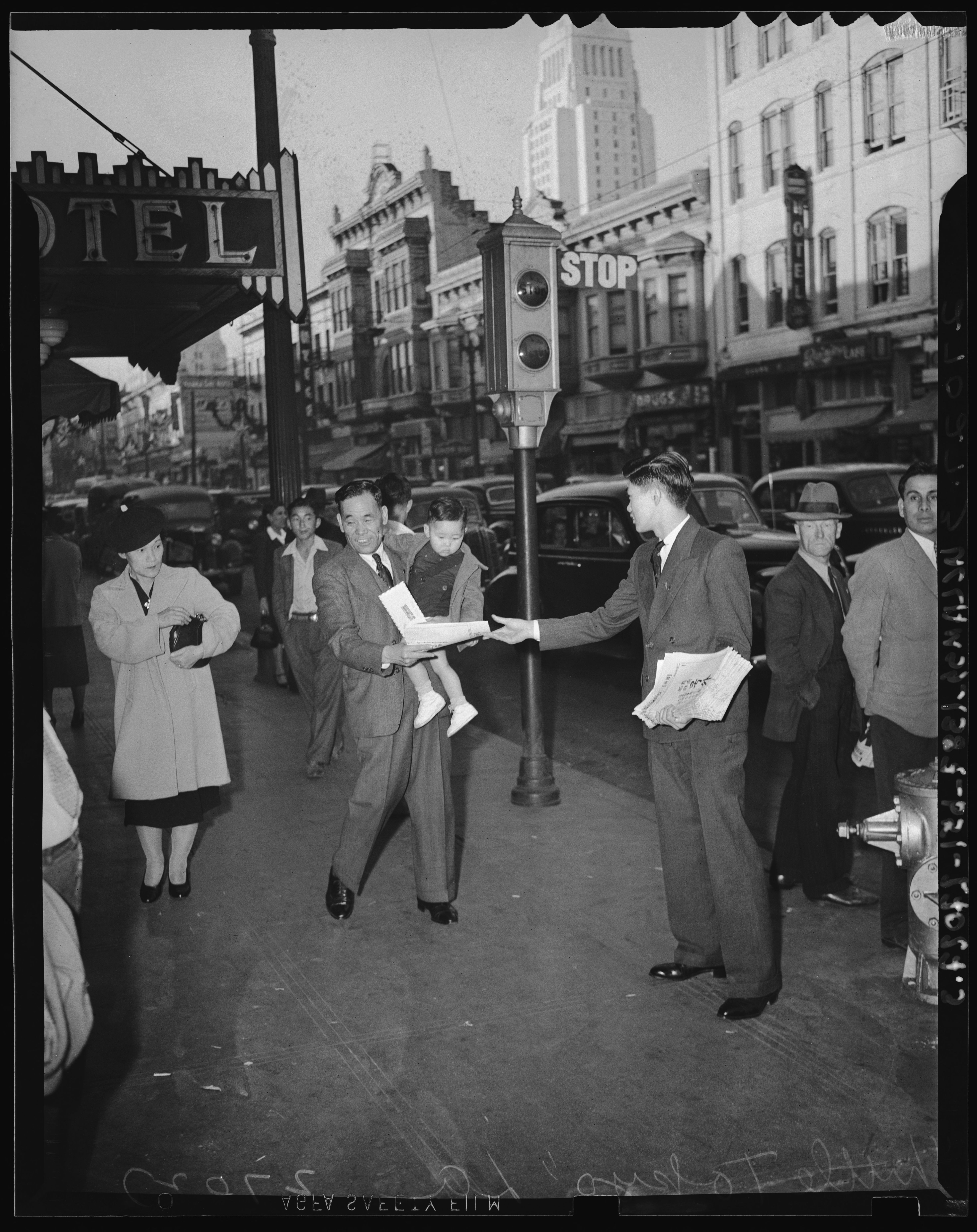
Little Tokyo ( ja, リトル・トーキョー) also known as Little Tokyo Historic District, is an ethnically Japanese American district in downtown Los Angeles and the heart of the largest Japanese-American population in North America. It is the largest and most populous of only three official Japantowns in the United States, all of which are in California (the other two are Japantown, San Francisco and Japantown, San Jose). Founded around the beginning of the 20th century, the area, sometimes called Lil' Tokyo, J-Town, 小東京 (Shō-tōkyō), is the cultural center for Japanese Americans in Southern California. It was declared a National Historic Landmark District in 1995. History In 1905 the area of "Little Tokyo" was described as "bounded by San Pedro, First and Requena streets and Central avenue. The ''Los Angeles Times'' added: "It has a population of about 3,500 Japanese, with quite a colony of Jews and Russians and a few Americans. . . . there are 10,000 Japanese i ... [...More Info...] [...Related Items...] OR: [Wikipedia] [Google] [Baidu] |
Little Armenia, Los Angeles
Little Armenia ( arm, Փոքր Հայաստան) is a neighborhood in Central Los Angeles, California. It is named after the Armenians who escaped genocide and made their way to Los Angeles during the early part of the 20th century. The area is served by the Metro B Line at the Hollywood/Western, Vermont/Sunset and Vermont/Santa Monica stations. History The context behind early ethnic-Armenian immigration to Hollywood and the surrounding areas was due to political strife abroad. Some immigrants came from Romania fleeing the Ceaușescu regime, from Lebanon due to the Lebanese Civil War, from Soviet Armenia inadvertently as a result of US's Jackson-Vanik amendment, from Iran as a result of the Iranian revolution as well as from other countries like Syria, Turkey and other countries. In 1999, the Honorary Mayor of Little Armenia, Garbis Keurjikian, also known as Garo, had a vision to establish an area in East Hollywood representing the Armenians who migrated to America. H ... [...More Info...] [...Related Items...] OR: [Wikipedia] [Google] [Baidu] |
Lincoln Heights, Los Angeles
Lincoln Heights is one of the oldest neighborhoods in Los Angeles, California, United States. It was originally called "East Los Angeles" from 1873 to 1917. It is a densely populated, mostly Latino and Asian neighborhood. It includes many historic landmarks and was known as "the Bedroom of the Pueblo". History Yaangna Village was located on what is now the current day site of Downey Park on Albion and Avenue 17. Lincoln Heights is considered to be one of the oldest neighborhoods outside of La Placita / Sonoratown dating to the 1870s and is found wholly within the original Spanish four leagues pueblo of the Los Angeles land grant. Located on bluffs overlooking the Los Angeles River and immersed in the floodplain, Lincoln Heights river adjacent land became the city's first Industrial Corridor. Aided by slave labor of the Kizh, it later became the home to some of the city's most notable downtown industrialists, who built numerous Victorian homes, some of which have been preserved u ... [...More Info...] [...Related Items...] OR: [Wikipedia] [Google] [Baidu] |
Larchmont, Los Angeles
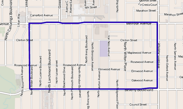
Larchmont is a half-square-mile neighborhood in the Central Los Angeles, central region of the City of Los Angeles, California. It has three schools and one small park. It has been the site of early and recent motion picture shoots. Geography According to the Greater Wilshire Neighborhood Council and the Larchmont Village Neighborhood Association, Larchmont's boundaries are Melrose Avenue on the north, Wilton Place on the east, Beverly Boulevard on the south, and Arden Boulevard on the west.Thomas Guide, Los Angeles County, 2004, pages 593 and 633 Adjacent neighborhoods are Hollywood, Los Angeles, Hollywood to the north, Wilshire Center, Los Angeles, Wilshire Center to the east, Windsor Square, Los Angeles, Windsor Square to the south, and Hancock Park, Los Angeles, Hancock Park to the west. According to the Mapping L.A. project of the ''Los Angeles Times,'' Larchmont is flanked by Hollywood, Los Angeles, Hollywood to the north, East Hollywood, Los Angeles, East Hollywood to the ... [...More Info...] [...Related Items...] OR: [Wikipedia] [Google] [Baidu] |
Koreatown, Los Angeles
Koreatown ( ko, 코리아타운) is a neighborhood in central Los Angeles, California, centered near Eighth Street and Irolo Street. Koreans began immigrating in larger numbers in the 1960s and found housing in the Mid-Wilshire area. Many opened businesses as they found rent and tolerance toward the growing Korean population. Many of the historic Art deco buildings with terra cotta façades have been preserved because the buildings remained economically viable for the new businesses.Hawthorne, Christopher (November 29, 2014"KOREATOWN'S COOL OLD BUILDINGS POINT TO L.A.'S FUTURE"''Los Angeles Times'' (online). Despite the name evoking a traditional ethnic enclave, the community is complex and has an impact on areas outside the traditional boundaries. While the neighborhood culture was historically oriented to the Korean immigrant population, Korean business owners are creating stronger ties to the Latino community in Koreatown. The community is highly diverse ethnically, with h ... [...More Info...] [...Related Items...] OR: [Wikipedia] [Google] [Baidu] |
Highland Park, Los Angeles
Highland Park is a neighborhood in Los Angeles, California, located in the city's Northeast Los Angeles, Northeast region. It was one of the first subdivisions of Los Angeles and is inhabited by a variety of ethnic and socioeconomic groups. History The area was settled thousands of years ago by Paleo-Indians, and would later be settled by the Kizh. After the founding of Los Angeles in 1781, the Corporal of the Guard at the Mission San Gabriel Arcángel, Jose Maria Verdugo, was granted the 36,403 acre Rancho San Rafael which included present day Highland Park. Drought in the mid-19th century resulted in economic hardship for the Verdugo family, which eventually compelled them to auction off Rancho San Rafael in 1869 for $3,500 over an unpaid loan. The San Rafael tract was purchased by Andrew Glassell and Albert J. Chapman, who leased it out to sheep herders. In 1885, during the 1880s land boom, it was sold to George Morgan and Albert Judson, who combined it with other parcels th ... [...More Info...] [...Related Items...] OR: [Wikipedia] [Google] [Baidu] |
Hermon, Los Angeles
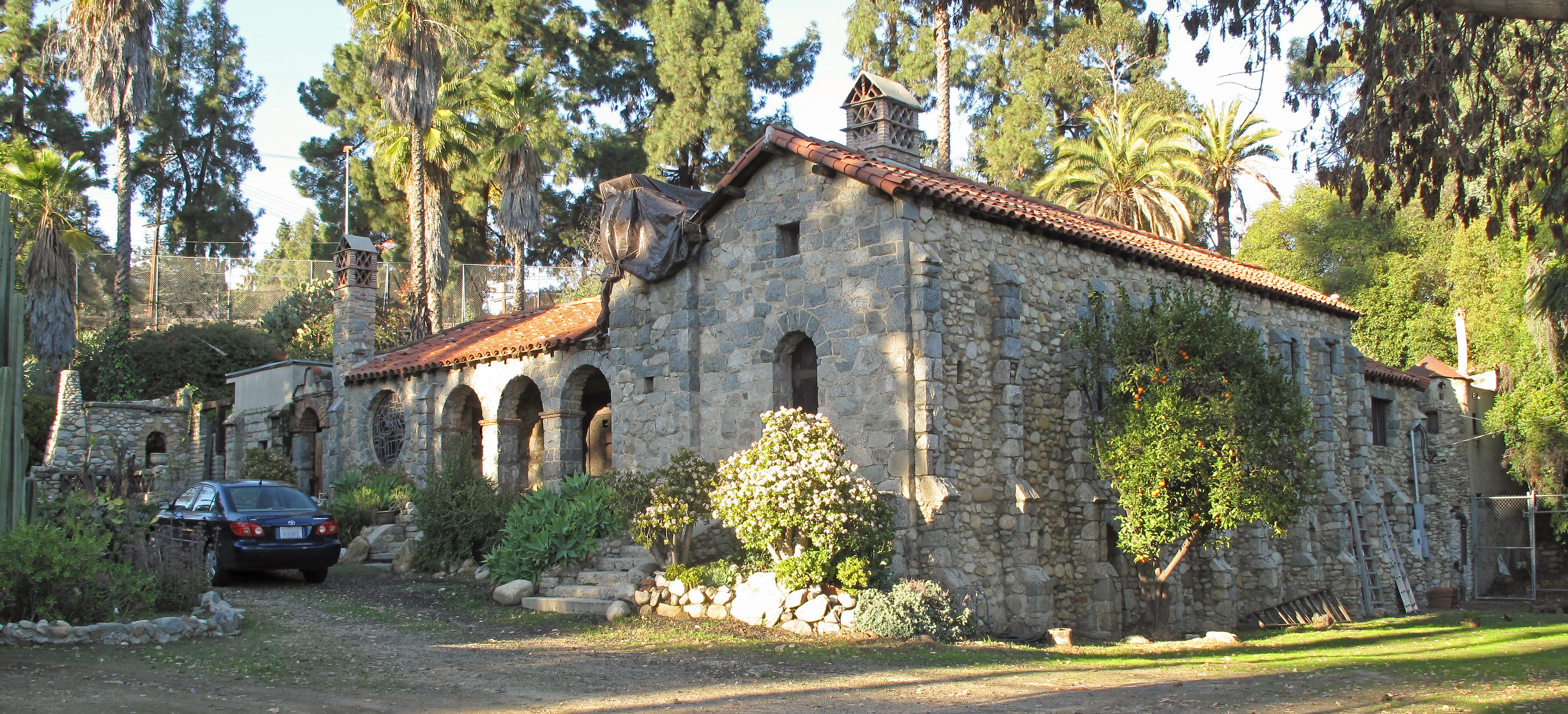
Hermon is a neighborhood in the northeast area of Los Angeles. It was established in 1903 and became part of Los Angeles in 1912. History Hermon was established in 1903, when the Free Methodist church group obtained the isolated valley from owner Ralph Rogers to establish a school. Rogers provided an additional one hundred building lots to sell for operating funds. The community of Hermon was organized around the campus, named after the biblical Mt. Hermon, and largely populated by families whose children attended the school. The school grew to become Los Angeles Pacific College in 1934, then closed in 1965 after the buildings were found to be too damaged to bring up to code. Up until 2003, the school campus held a private college prep high school, Pacific Christian. It is now owned by Bethesda Christian University and has been leased to Los Angeles College Prep Academy (LACPA) (formerly L.A. International Charter High School). Hermon was annexed into Los Angeles in 1912. Be ... [...More Info...] [...Related Items...] OR: [Wikipedia] [Google] [Baidu] |

.jpg)


