|
├śvre Eiker
├śvre Eiker is a municipality in Buskerud county, Norway. It is part of the traditional region of Eiker. The administrative centre of the municipality is the village of Hokksund. The old municipality of Eiker was divided into ''├śvre Eiker'' (upper Eiker) and '' Nedre Eiker'' (lower) on 1 July 1885. As of 2015, more employees worked for the unicipalgovernment and in the service sector, than in any other field of employment; even fewerŌĆö16 %ŌĆöare employed in construction or in lectricalpower companies and water companies; 3%work in the manufacturing sector. General information Name The Old Norse form of the name was ''Eikjar''. The name is the plural form of ''eiki'' which means "oak wood". The meaning of ''├śvre Eiker'' is "(the) upper (part of) Eiker". (The municipality of Eiker was divided in 1885.) Coat-of-arms The coat-of-arms is from modern times. They were granted on 24 October 1981. The arms show three silver oak leaves and two acorns on a blue background. T ... [...More Info...] [...Related Items...] OR: [Wikipedia] [Google] [Baidu] |
Eiker
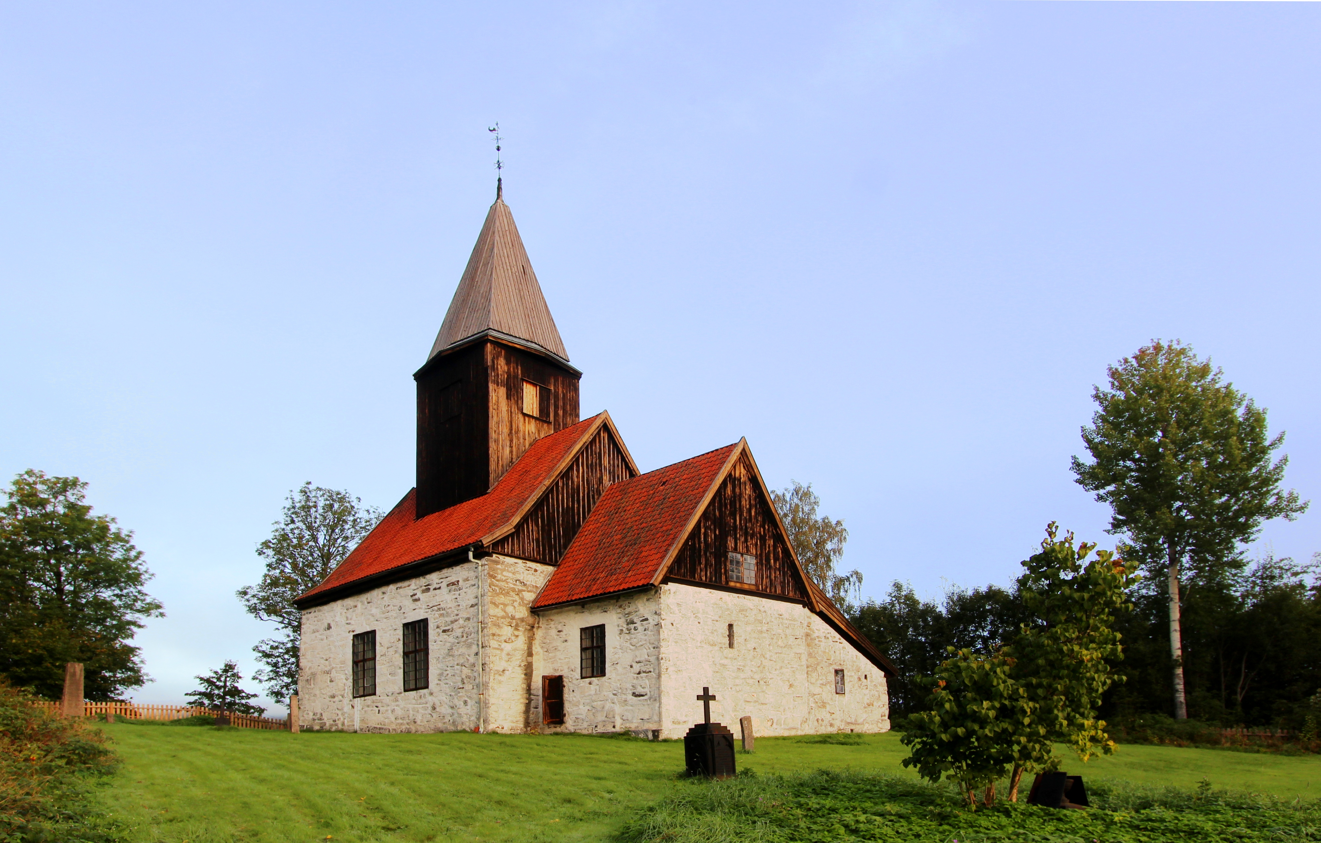
Eiker is a traditional district in the county of Buskerud, Norway. History Eiker consists of the municipalities of Nedre Eiker and ├śvre Eiker. The area is located in the southern part of Buskerud county. Eiker is an agricultural area with a long history. The area was first inhabited around 8000 BC. During the early Viking Age, Eiker was the western extension of the kingdom of Vingulmark. Somewhat later, it became part of the kingdom of Vestfold. The parish of ''Eker'' was established as a municipality on 1 January 1838 (see formannskapsdistrikt). It was divided into Nedre Eiker and ├śvre Eiker on 1 July 1885. Fiskum Old Church Fiskum Old Church (''Fiskum gamle kirke'') is located in ├śvre Eiker near the village of Darbu. It is a medieval era, Romanesque church dating from approximately 1200 A.D. The church was dedicated to Saint Olav. Fiskum Old Church was constructed in a rectangular shape and has 150 seats. The church was built of stone fracture in lime mortar and p ... [...More Info...] [...Related Items...] OR: [Wikipedia] [Google] [Baidu] |
Norwegian Language
Norwegian ( ) is a North Germanic language from the Indo-European language family spoken mainly in Norway, where it is an official language. Along with Swedish and Danish, Norwegian forms a dialect continuum of more or less mutually intelligible local and regional varieties; some Norwegian and Swedish dialects, in particular, are very close. These Scandinavian languages, together with Faroese and Icelandic as well as some extinct languages, constitute the North Germanic languages. Faroese and Icelandic are not mutually intelligible with Norwegian in their spoken form because continental Scandinavian has diverged from them. While the two Germanic languages with the greatest numbers of speakers, English and German, have close similarities with Norwegian, neither is mutually intelligible with it. Norwegian is a descendant of Old Norse, the common language of the Germanic peoples living in Scandinavia during the Viking Age. Today there are two official forms of ''written'' ... [...More Info...] [...Related Items...] OR: [Wikipedia] [Google] [Baidu] |
Holmestrand
is a List of towns and cities in Norway, town in Holmestrand Municipality in Vestfold county, Norway. The town is the administrative centre of the municipality. It is located along the shore of the Ytre Oslofjord, about northwest of the Horten (town), town of Horten and about south of the village of Sande i Vestfold. The large Drammen (town), town of Drammen lies about to the north. The town has a population (2024) of 8,258 and a population density of . History Located around the Oslofjord, Holmestrand developed as a timber/lumber port starting around 1550, when the Dutch people, Dutch came here for timber. In 1663, the place became a customs office under the nearby city of T├Ėnsberg. In 1716, the northern part of Holmestrand was reduced to ashes after a large fire spread through the area. In 1744, King Christian VI of Denmark, Christian VI designated it a ladested. In 1752, the new King Frederick V of Denmark, Frederik V granted it kj├Ėpstad (town) status. In the era of ... [...More Info...] [...Related Items...] OR: [Wikipedia] [Google] [Baidu] |
Metre
The metre (or meter in US spelling; symbol: m) is the base unit of length in the International System of Units (SI). Since 2019, the metre has been defined as the length of the path travelled by light in vacuum during a time interval of of a second, where the second is defined by a hyperfine transition frequency of caesium. The metre was originally defined in 1791 by the French National Assembly as one ten-millionth of the distance from the equator to the North Pole along a great circle, so the Earth's polar circumference is approximately . In 1799, the metre was redefined in terms of a prototype metre bar. The bar used was changed in 1889, and in 1960 the metre was redefined in terms of a certain number of wavelengths of a certain emission line of krypton-86. The current definition was adopted in 1983 and modified slightly in 2002 to clarify that the metre is a measure of proper length. From 1983 until 2019, the metre was formally defined as the length of the pat ... [...More Info...] [...Related Items...] OR: [Wikipedia] [Google] [Baidu] |
Lake
A lake is often a naturally occurring, relatively large and fixed body of water on or near the Earth's surface. It is localized in a basin or interconnected basins surrounded by dry land. Lakes lie completely on land and are separate from the ocean, although they may be connected with the ocean by rivers. Lakes, as with other bodies of water, are part of the water cycle, the processes by which water moves around the Earth. Most lakes are fresh water and account for almost all the world's surface freshwater, but some are salt lakes with salinities even higher than that of seawater. Lakes vary significantly in surface area and volume of water. Lakes are typically larger and deeper than ponds, which are also water-filled basins on land, although there are no official definitions or scientific criteria distinguishing the two. Lakes are also distinct from lagoons, which are generally shallow tidal pools dammed by sandbars or other material at coastal regions of ocean ... [...More Info...] [...Related Items...] OR: [Wikipedia] [Google] [Baidu] |
Eikeren
Eikeren or Eikern is a long, deep lake in eastern Norway. The lake is located on the border of ├śvre Eiker Municipality in Buskerud county and Holmestrand Municipality in Vestfold county (the majority of the lake is in Buskerud). It is the largest lake in all of Vestfold county, measuring about long and wide, and reaching a depth of . The village of Eidsfoss lies at the southeastern end of the lake. At Eidsfoss, water flows into the lake from the nearby lakes Bergsvann, Vikevann, Haugestadvann and Hillestadvann. Eikeren lake also receives water flowing into it from the rivers Hakavikelva and Steinbruelva. The lake flows out through a narrow strait (''Sundet'') on the north end of the lake. The strait flows into a smaller lake Fiskumvannet. Through this strait, water flows at an average rate of . From Fiskumvannet, water runs out into the river Vestfosselva to the village of Vestfossen. The river then goes on to the town of Hokksund, where it splits into two rivers that bot ... [...More Info...] [...Related Items...] OR: [Wikipedia] [Google] [Baidu] |
Drammen
Drammen () is a city and municipality in Buskerud county, Norway. The port and river city of Drammen is centrally located in the south-eastern and most populated part of Norway. Drammen municipality also includes smaller towns and villages such as Konnerud, Svelvik, Mj├Ėndalen and Skoger. Location Drammen is located west of the Oslofjord inlet, situated approximately 44 km (27 mi) southwest of the capital city of Oslo. There are more than 100,000 inhabitants in the municipality, though the city is the regional capital of an area with around 82,000 residents. Drammen, and its adjacent communities, are experiencing more socioeconomic and population growth than ever before. The city makes good use of the Drammensfjord, a waterway utilised for recreation, fishing and other activities, as well as waterfront housing. Name and coat of arms The Old Norse form of the city's name was ''Drafn'', and this was originally the name of the inner part of Drammensfjord. The fjord is, howev ... [...More Info...] [...Related Items...] OR: [Wikipedia] [Google] [Baidu] |
Modum
Modum is a municipality in Buskerud county, Norway. The administrative centre of the municipality is the town of Vikersund. The municipality of Modum was established on 1 January 1838 (see formannskapsdistrikt). The area has a long tradition of skiing with several famous skiers. Modum is home to one of the largest ski jumping hills in the world, Vikersundbakken which is situated in Heggen, outside Geithus. The hill record, established in 2017 is a jump of . General information Name The municipality (originally the parish) is named after the old ''Modum'' farm (Old Norse: ''M├│├░heimr''), since the first church was built here. The first element is ''m├│├░a'' which means "river" (here the Drammenselva river) and the last element is ''heimr'' which means "home", " homestead", or "farm". The name of the farm was later changed to ''Buskerud''. Coat-of-arms The coat-of-arms is from modern times. They were granted on 15 March 1985. The arms show three wavy silver lines ŌĆ£ party ... [...More Info...] [...Related Items...] OR: [Wikipedia] [Google] [Baidu] |
Drammenselva
Drammenselva () is a river in Buskerud Counties of Norway, county, southeastern Norway. Location Drammenselva is one of the largest rivers in Norway, with a drainage basin of about and a Discharge (hydrology), discharge of per second. Drammen River's total length is making it the fifth longest river in Norway. Its 48 km course runs from Tyrifjorden in the north to Drammensfjord in the south, where it cuts through the centre of the city of Drammen (town), Drammen. The Drammen River gathers inflow from several streams and rivers. The largest include the Simoa River. The whole Drainage system (geomorphology), drainage system which includes the Drammenselva as the lowest part is known as Drammensvassdraget and is located in the counties of Innlandet and Buskerud. Development and usage For centuries the river was used for log driving, transporting timber from the forests in Eiker to the many paper mills and other industry along the river. From the 1850s onwards, many steam-po ... [...More Info...] [...Related Items...] OR: [Wikipedia] [Google] [Baidu] |
Coat Of Arms Of Tingvoll
Tingvoll is a municipality in M├Ėre og Romsdal county, Norway. It is part of the Nordm├Ėre region. The administrative centre is the village of Tingvollv├źgen. Other villages include Meisingset, Kvisvik, Grimstad, and Torjulv├źgen. The municipality encompasses a peninsula on the mainland as well as a few surrounding islands. Norwegian National Road 70 and European route E39 both run through the municipality. The municipality is the 253rd largest by area out of the 357 municipalities in Norway. Tingvoll Municipality is the 226th most populous municipality in Norway with a population of 3,041. The municipality's population density is and its population has decreased by 0.8% over the previous 10-year period. General information The parish of Tingvoll was established as a municipality on 1 January 1838 (see formannskapsdistrikt law). On 1 January 1866, the northern part of the municipality (population: 1,222) was separated to form the new Straumsnes Municipality. On 1 January ... [...More Info...] [...Related Items...] OR: [Wikipedia] [Google] [Baidu] |


