|
Temperate Southern Africa
Temperate Southern Africa is a biogeography, biogeographic region of the Earth's seas, comprising the temperate waters of southern Africa, where the Atlantic Ocean and Indian Ocean meet. It includes the coast of South Africa and Namibia, and reaches into southern Angola. It also includes the remote islands of Île Amsterdam, Amsterdam and Île Saint-Paul, Saint-Paul, to the east in the southern Indian Ocean. Temperate Southern Africa is a marine realm, one of the great biogeographic divisions of the world's ocean basins. The boundary between the Temperate Southern Africa and Western Indo-Pacific marine realms is near Lake St. Lucia, in South Africa near the border with Mozambique. The realm extends up the Atlantic coast of Africa to Tômbua in southern Angola, where it transitions to the Tropical Atlantic realm. Subdivisions The Temperate Southern Africa realm is further subdivided into three marine provinces. Benguela province includes the Atlantic portion of the realm, influenc ... [...More Info...] [...Related Items...] OR: [Wikipedia] [Google] [Baidu] |
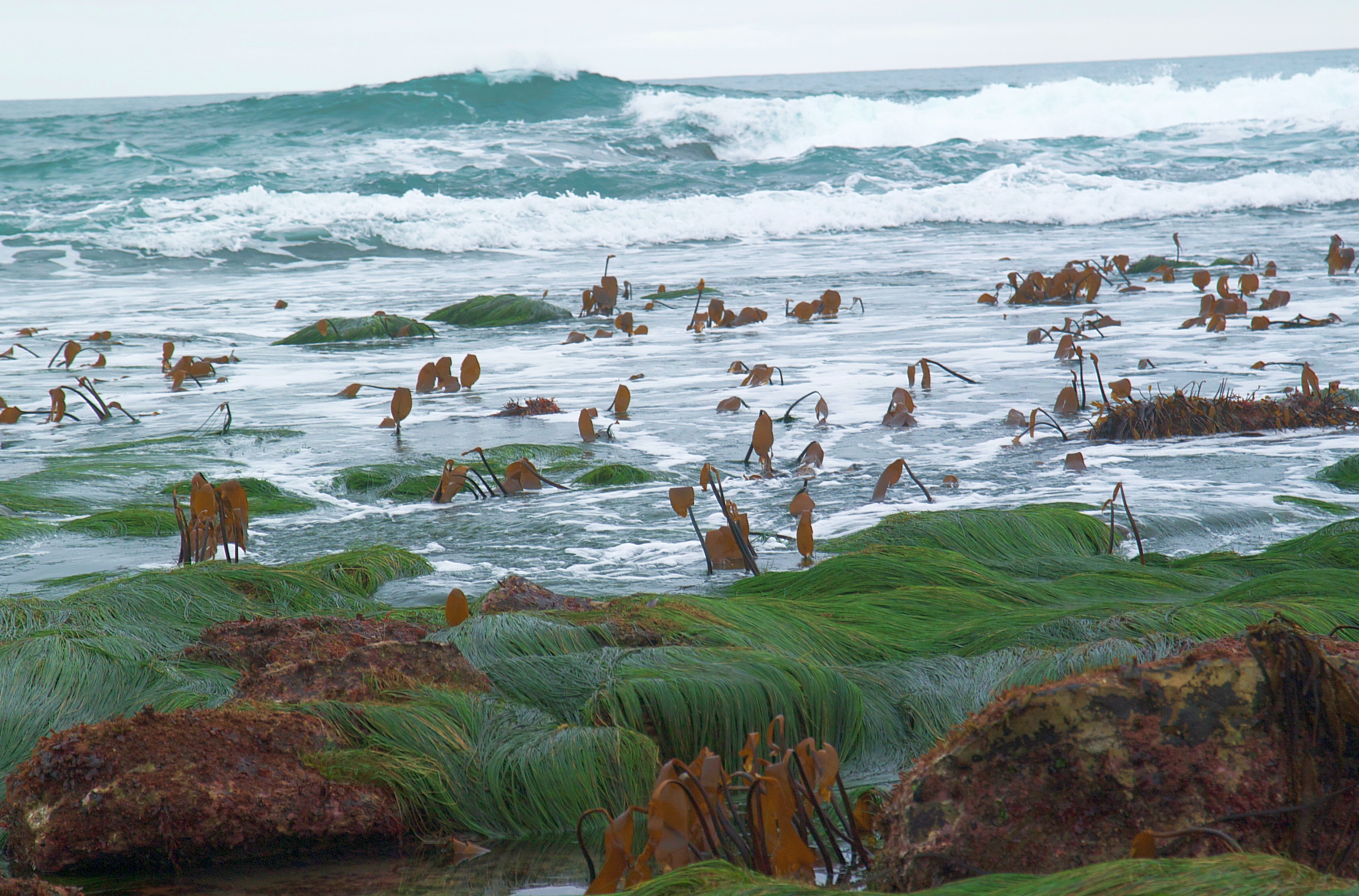
Laminaria Kelp On Top Of The Pinnacle At 13th Apostle PA031640
''Laminaria'' is a genus of brown algae, brown seaweed in the order Kelp, Laminariales (kelp), comprising 31 species native to the north Atlantic and northern Pacific Oceans. This economically important genus is characterized by long, leathery Lamina (algae), laminae and relatively large size. Some species are called Devil's apron, due to their shape, or sea colander, due to the perforations present on the Lamina (algae), lamina. Others are referred to as ''tangle''. ''Laminaria'' form a habitat for many fish and invertebrates. The life cycle of ''Laminaria'' has wikt:heteromorphic, heteromorphic alternation of generations which differs from ''Fucus''. At meiosis the male and female zoospores are produced separately, then germinate into male and female gametophytes. The female egg matures in the oogonium until the male sperm fertilizes it. Life-Cycle: The most apparent form of ''Laminaria'' is its sporophyte phase, a structure composed of the holdfast (biology), holdfast, the Sti ... [...More Info...] [...Related Items...] OR: [Wikipedia] [Google] [Baidu] |
Mozambique
Mozambique (), officially the Republic of Mozambique ( pt, Moçambique or , ; ny, Mozambiki; sw, Msumbiji; ts, Muzambhiki), is a country located in southeastern Africa bordered by the Indian Ocean to the east, Tanzania to the north, Malawi and Zambia to the northwest, Zimbabwe to the west, and Eswatini and South Africa to the southwest. The sovereign state is separated from the Comoros, Mayotte and Madagascar by the Mozambique Channel to the east. The capital and largest city is Maputo. Notably Northern Mozambique lies within the monsoon trade winds of the Indian Ocean and is frequentely affected by disruptive weather. Between the 7th and 11th centuries, a series of Swahili port towns developed on that area, which contributed to the development of a distinct Swahili culture and language. In the late medieval period, these towns were frequented by traders from Somalia, Ethiopia, Egypt, Arabia, Persia, and India. The voyage of Vasco da Gama in 1498 marked the arrival of t ... [...More Info...] [...Related Items...] OR: [Wikipedia] [Google] [Baidu] |
Temperate Southern Africa
Temperate Southern Africa is a biogeography, biogeographic region of the Earth's seas, comprising the temperate waters of southern Africa, where the Atlantic Ocean and Indian Ocean meet. It includes the coast of South Africa and Namibia, and reaches into southern Angola. It also includes the remote islands of Île Amsterdam, Amsterdam and Île Saint-Paul, Saint-Paul, to the east in the southern Indian Ocean. Temperate Southern Africa is a marine realm, one of the great biogeographic divisions of the world's ocean basins. The boundary between the Temperate Southern Africa and Western Indo-Pacific marine realms is near Lake St. Lucia, in South Africa near the border with Mozambique. The realm extends up the Atlantic coast of Africa to Tômbua in southern Angola, where it transitions to the Tropical Atlantic realm. Subdivisions The Temperate Southern Africa realm is further subdivided into three marine provinces. Benguela province includes the Atlantic portion of the realm, influenc ... [...More Info...] [...Related Items...] OR: [Wikipedia] [Google] [Baidu] |
Marine Ecoregions Of The South African Exclusive Economic Zone
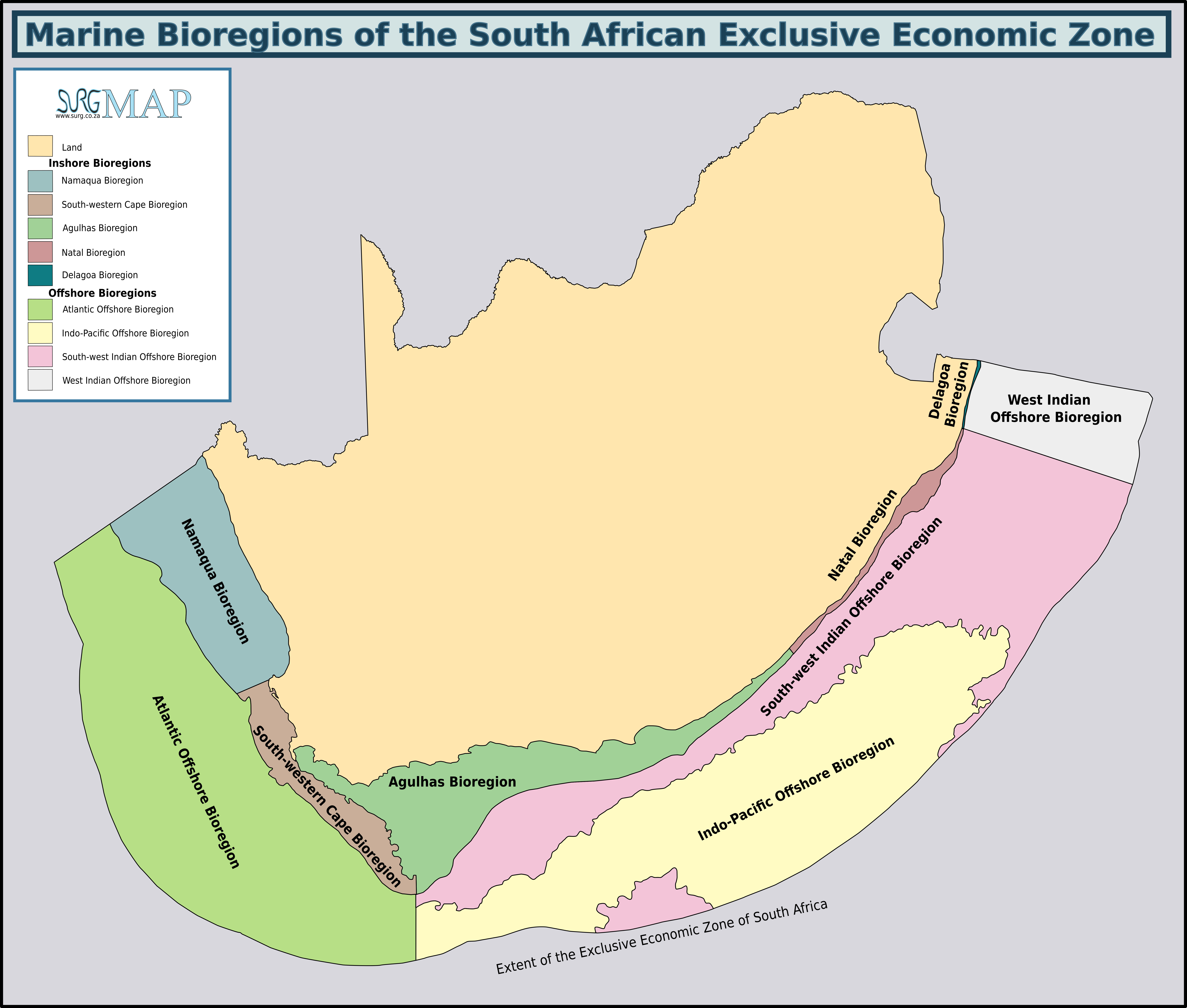
The marine ecoregions of the South African exclusive economic zone are a set of geographically delineated regions of similar ecological characteristics on a fairly broad scale, covering the exclusive economic zone along the South African coast. There were originally five inshore bioregions defined over the continental shelf and four offshore bioregions covering the continental slope and abyssal regions. These bioregions were used for conservation research and planning. They were defined in the South African National Spatial Biodiversity Assessment of 2004. The South African National Spatial Biodiversity Assessment of 2011 amended this to reduce the number of regions to four inshore and two offshore and rename them as ecoregions. The exclusive economic zone An exclusive economic zone (EEZ) is a sea zone prescribed by the United Nations Convention on the Law of the Sea over which a state has special rights regarding the exploration and use of marine resources, including energy ... [...More Info...] [...Related Items...] OR: [Wikipedia] [Google] [Baidu] |
Natal Marine Ecoregion
The marine ecoregions of the South African exclusive economic zone are a set of geographically delineated regions of similar ecological characteristics on a fairly broad scale, covering the exclusive economic zone along the South African coast. There were originally five inshore bioregions defined over the continental shelf and four offshore bioregions covering the continental slope and abyssal regions. These bioregions were used for conservation research and planning. They were defined in the South African National Spatial Biodiversity Assessment of 2004. The South African National Spatial Biodiversity Assessment of 2011 amended this to reduce the number of regions to four inshore and two offshore and rename them as ecoregions. The exclusive economic zone An exclusive economic zone (EEZ) is a sea zone prescribed by the United Nations Convention on the Law of the Sea over which a state has special rights regarding the exploration and use of marine resources, including energy ... [...More Info...] [...Related Items...] OR: [Wikipedia] [Google] [Baidu] |
Namaqua Marine Ecoregion
The marine ecoregions of the South African exclusive economic zone are a set of geographically delineated regions of similar ecological characteristics on a fairly broad scale, covering the exclusive economic zone along the South African coast. There were originally five inshore bioregions defined over the continental shelf and four offshore bioregions covering the continental slope and abyssal regions. These bioregions were used for conservation research and planning. They were defined in the South African National Spatial Biodiversity Assessment of 2004. The South African National Spatial Biodiversity Assessment of 2011 amended this to reduce the number of regions to four inshore and two offshore and rename them as ecoregions. The exclusive economic zone An exclusive economic zone (EEZ) is a sea zone prescribed by the United Nations Convention on the Law of the Sea over which a state has special rights regarding the exploration and use of marine resources, including energy ... [...More Info...] [...Related Items...] OR: [Wikipedia] [Google] [Baidu] |
Cape Of Good Hope
The Cape of Good Hope ( af, Kaap die Goeie Hoop ) ;''Kaap'' in isolation: pt, Cabo da Boa Esperança is a rocky headland on the Atlantic coast of the Cape Peninsula in South Africa. A common misconception is that the Cape of Good Hope is the southern tip of Africa, based on the misbelief that the Cape was the dividing point between the Atlantic and Indian oceans, and have nothing to do with north or south. In fact, by looking at a map, the southernmost point of Africa is Cape Agulhas about to the east-southeast. The currents of the two oceans meet at the point where the warm-water Agulhas current meets the cold-water Benguela current and turns back on itself. That oceanic meeting point fluctuates between Cape Agulhas and Cape Point (about east of the Cape of Good Hope). When following the western side of the African coastline from the equator, however, the Cape of Good Hope marks the point where a ship begins to travel more eastward than southward. Thus, the first mode ... [...More Info...] [...Related Items...] OR: [Wikipedia] [Google] [Baidu] |
Agulhas Current
The Agulhas Current () is the western boundary current of the southwest Indian Ocean. It flows south along the east coast of Africa from 27°S to 40°S. It is narrow, swift and strong. It is suggested that it is the largest western boundary current in the world ocean, with an estimated net transport of 70 sverdrups (70 million cubic metres per second), as western boundary currents at comparable latitudes transport less — Brazil Current (16.2 Sv), Gulf Stream (34 Sv), Kuroshio (42 Sv). Physical properties The sources of the Agulhas Current are the East Madagascar Current (25 Sv), the Mozambique Current (5 Sv) and a recirculated part of the south-west Indian subgyre south of Madagascar (35 Sv). The net transport of the Agulhas Current is estimated as 100 Sv. The flow of the Agulhas Current is directed by the topography. The current follows the continental shelf from Maputo to the tip of the Agulhas Bank (250 km south of Cape Agulhas). Here the momentum of the current ... [...More Info...] [...Related Items...] OR: [Wikipedia] [Google] [Baidu] |
Tropical Atlantic
The Tropical Atlantic realm is one of twelve marine realms that cover the world's coastal seas and continental shelves. The Tropical Atlantic covers both sides of the Atlantic. In the western Atlantic, it extends from Bermuda, southern Florida, and the southern Gulf of Mexico through the Caribbean and along South America's Atlantic coast to Cape Frio in Brazil's Rio de Janeiro state. In the Eastern Atlantic, it extends along the African coast from Cape Blanco in Mauritania to the Tigres Peninsula on the coast of Angola. It also includes the seas around St. Helena and Ascension islands. The Tropical Atlantic is bounded on the north and south by temperate ocean realms. The Temperate Northern Atlantic realm lies to the north on both the North American and African-European shores of the Atlantic. To the south, the ocean realms conform to the continental margins, not the ocean basins; the Temperate South America realm lies to the south along the South American coast, and the Temper ... [...More Info...] [...Related Items...] OR: [Wikipedia] [Google] [Baidu] |
Tômbua
Tômbua, formerly known as Porto Alexandre, is a city and municipality in Angola, in Namibe Province. The municipality has a population of 55,494 and the city has a population of 46,573 in 2014. It is located on the shore of Porto Alexandre, an important harbor on the South Atlantic Ocean for oil production and fishing. The villages of Yona and Saint Martin of the Tigers are part of the municipality of Tômbua. Economy The port had refrigeration facilities installed with European Union assistance at the Tombwe canning factory. It was during Portuguese Angola the largest fishing port of Angola and one of the largest in West Africa. It was established by fishermen from Olhão, Algarve around 1863 in a sheltered bay, and joined by the fishermen of Póvoa de Varzim Póvoa de Varzim (, ) is a Portuguese city in Northern Portugal and sub-region of Greater Porto, from its city centre. It sits in a sandy coastal plain, a cuspate foreland, halfway between the Minho and Douro rivers. ... [...More Info...] [...Related Items...] OR: [Wikipedia] [Google] [Baidu] |
Lake St
Lake Street may refer to: *Lake Street (Chicago) *Lake Street (Minneapolis) Lake Street is a major east-west thoroughfare between 29th and 31st streets in Minneapolis, Minnesota United States. From its western most end at the city's limits, Lake Street reaches the Chain of Lakes, passing over a small channel linking B ... See also * Lake Street station (other) {{dab, road ... [...More Info...] [...Related Items...] OR: [Wikipedia] [Google] [Baidu] |


