|
Teltow-FlûÊming
Teltow-FlûÊming () is a ''Kreis'' (district) in the southwestern part of Brandenburg, Germany. Neighboring districts are (from the east clockwise) Dahme-Spreewald, Elbe-Elster, the districts Wittenberg (district), Wittenberg in Saxony-Anhalt, the district Potsdam-Mittelmark, and the ''Bundesland'' Berlin. Geography The district is named after the two main regions. The Teltow (region), Teltow is an agricultural belt south of Berlin. The FlûÊming is a wooded hill chain in the south; the portion located in this district is called the Lower FlûÊming, while the Higher FlûÊming is situated in Potsdam-Mittelmark. History The district was formed in December 1993 by merging the previous districts Luckenwalde, Jû¥terbog and Zossen, but also including small parts from other former districts such as Luckau. Demography File:BevûÑlkerungsentwicklung Landkreis Teltow-FlûÊming.pdf, Development of Population since 1875 within the Current Boundaries (Blue Line: Population; Dotted Line: Comparis ... [...More Info...] [...Related Items...] OR: [Wikipedia] [Google] [Baidu] |
Ludwigsfelde
Ludwigsfelde is a town in the north of the district Teltow-FlûÊming in Brandenburg. Geography Location The town is located south of Berlin in the district Teltow-FlûÊming on the plateau of Teltow. In earlier times, it was part of the district Zossen. Parts of the town Since 1997/2003 the following villages are part of the city: * Ahrensdorf *Genshagen (with Genshagen Palace) *GrûÑben * Groû Schulzendorf * Jû¥tchendorf * Kerzendorf * LûÑwenbruch * Mietgendorf * Schiaû * Siethen * Wietstock Demography File:BevûÑlkerungsentwicklung Ludwigsfelde.pdf, Development of Population since 1875 within the Current Boundaries (Blue Line: Population; Dotted Line: Comparison to Population Development of Brandenburg state; Grey Background: Time of Nazi rule; Red Background: Time of Communist rule) File:BevûÑlkerungsprognosen Ludwigsfelde.pdf, Recent Population Development and Projections (Population Development before Census 2011 (blue line); Recent Population Development according to the ... [...More Info...] [...Related Items...] OR: [Wikipedia] [Google] [Baidu] |
Blankenfelde-Mahlow
Blankenfelde-Mahlow is a municipality in the Teltow-FlûÊming district of Brandenburg, Germany. It is situated approximately south of Berlin. History The municipality shared its borders with the former West Berlin, and so during the period 1961-1990 it was separated. Blankenfelde Blankenfelde was first mentioned in documents in 1375. However, a substantial part of this district, the so-called Gagfah settlement, did not develop until the 1930s, after the Sû¥d-Berlin Bodenaktiengesellschaft had acquired and parceled out the area. As a result, the population increased significantly - from 766 inhabitants in 1930 to 6228 inhabitants in 1939. Mahlow Mahlow was first mentioned in documents in 1287. After the place had received a station in 1875, the immigration of wealthy Berliners. Its constituency is under Teltow from 1945 until its dissolution in 1952. As early as 1950, the community Glasow was merged with the community Mahlow. The construction of the Berlin Wall from 13 August ... [...More Info...] [...Related Items...] OR: [Wikipedia] [Google] [Baidu] |
Baruth/Mark
Baruth/Mark is a town in the Teltow-FlûÊming district of Brandenburg, Germany. It is situated 24 km east of Luckenwalde, and 53 km south of Berlin. Geography Baruth/Mark is structured in the following parts of town,Main constitution of the town of Baruth/MarPDF which are all villages and mainly former municipalities: * Baruth/Mark ** Klein Ziescht * Dornswalde * Groû Ziescht ** Kemlitz * Horstwalde * Klasdorf ** Glashû¥tte * Lieûen * Merzdorf * Mû¥ckendorf * Paplitz * Petkus ** Charlottenfelde * Radeland * SchûÑbendorf Demography File:BevûÑlkerungsentwicklung Baruth.pdf, Development of Population since 1875 within the Current Boundaries (Blue Line: Population; Dotted Line: Comparison to Population Development of Brandenburg state; Grey Background: Time of Nazi rule; Red Background: Time of Communist rule) File:BevûÑlkerungsprognosen Baruth.pdf, Recent Population Development and Projections (Population Development before Census 2011 (blue line); Recent Populati ... [...More Info...] [...Related Items...] OR: [Wikipedia] [Google] [Baidu] |
Luckenwalde
Luckenwalde (; Upper and dsb, éukowc) is the capital of the Teltow-FlûÊming district in the German state of Brandenburg. It is situated on the Nuthe river north of the FlûÊming Heath, at the eastern rim of the Nuthe-Nieplitz Nature Park, about south of Berlin. The town area includes the villages of Frankenfelde and Kolzenburg. Overview The former Slavic settlement of ''Lugkin'' was conquered by Margrave Conrad Wettin of Meissen in the course of the 1147 Wendish Crusade. ''Lukenwalde'' Castle was first mentioned in a 1216 deed as a burgward of the Bishopric of Brandenburg, it was acquired by Zinna Abbey in 1285. Together with Zinna it remained under the rule of the Archbishopric of Magdeburg and its successor, the Prussian Duchy of Magdeburg until it was attached to the Margraviate of Brandenburg in 1773. Originating in the 17th century, Luckenwalde's cloth and wool factories did not spring up till the reign of King Frederick II of Prussia and soon were among the most e ... [...More Info...] [...Related Items...] OR: [Wikipedia] [Google] [Baidu] |
Dahme, Brandenburg
Dahme (also: Dahme/Mark) is a town in the Teltow-FlûÊming district of Brandenburg, Germany. It is situated on the Dahme River, 30 km southeast of Luckenwalde, and 38 km west of Lû¥bbenau. History From 1815 to 1947, Dahme was part of the Prussian Province of Brandenburg. From 1952 to 1990, it was part of the Bezirk Cottbus of East Germany. Demography File:BevûÑlkerungsentwicklung Stadt Dahme-Mark.pdf, Development of Population since 1875 within the Current Boundaries (Blue Line: Population; Dotted Line: Comparison to Population Development of Brandenburg state. Grey Background: Time of Nazi rule; Red Background: Time of Communist rule.) File:BevûÑlkerungsprognosen Stadt Dahme-Mark.pdf, Recent Population Development (Blue Line) and Forecasts Notable people * Karsten Greve (born 1946), an internationally renowned art dealer. * Johannes Groenland (1824ã1891), botanist and microscopist who worked for Vilmorin and was a professor of natural science in Dahme. * Herman ... [...More Info...] [...Related Items...] OR: [Wikipedia] [Google] [Baidu] |
NiedergûÑrsdorf
NiedergûÑrsdorf is a municipality in the Teltow-FlûÊming district of Brandenburg, Germany. Demography File:BevûÑlkerungsentwicklung NiedergûÑrsdorf.pdf, Development of Population since 1875 within the Current Boundaries (Blue Line: Population; Dotted Line: Comparison to Population Development of Brandenburg state; Grey Background: Time of Nazi rule; Red Background: Time of Communist rule) File:BevûÑlkerungsprognosen NiedergûÑrsdorf.pdf, Recent Population Development and Projections (Population Development before Census 2011 (blue line); Recent Population Development according to the Census in Germany in 2011 (blue bordered line); Projections by the Brandenburg state for 2005-2030 (yellow line); for 2017-2030 (scarlet line), for 2020-2030 (green line) Photo gallery File:Bloensdorf church.jpg, BlûÑnsdorf File:Niedergoersdorf_Mellnsdorf_church.jpg, Mellnsdorf File:Seehausen Church.jpg, Seehausen See also *Dennewitz Dennewitz is a village of Germany, in the federal state and ... [...More Info...] [...Related Items...] OR: [Wikipedia] [Google] [Baidu] |
Groûbeeren
Groûbeeren is a municipality in the district of Teltow-FlûÊming in the German state of Brandenburg. Geography Located about 3 km south of Berlin's city limits. It includes the localities of ''Diedersdorf'', ''Heinersdorf'' and ''Kleinbeeren''. Demography File:BevûÑlkerungsentwicklung Groûbeeren.pdf, Development of Population since 1875 within the Current Boundaries (Blue Line: Population; Dotted Line: Comparison to Population Development of Brandenburg state; Grey Background: Time of Nazi rule; Red Background: Time of Communist rule) File:BevûÑlkerungsprognosen Groûbeeren.pdf, Recent Population Development and Projections (Population Development before Census 2011 (blue line); Recent Population Development according to the Census in Germany in 2011 (blue bordered line); Official projections for 2005-2030 (yellow line); for 2017-2030 (scarlet line); for 2020-2030 (green line) History Groûbeeren was first mentioned in a 1271 deed. It was devastated in the Thirty Year ... [...More Info...] [...Related Items...] OR: [Wikipedia] [Google] [Baidu] |
Am Mellensee
Am Mellensee is a municipality in the Teltow-FlûÊming district of Brandenburg, Germany. The municipality, south of Berlin, is the home of the Benedictine Abbey of St. Gertrud. An Associated Press story appearing in the August 1, 2011 online version of the St. Louis Post-Dispatch detailed the breadmaking there. The nuns make Communion wafers for eastern Germany's Catholics, including those in the Berlin area, and some Lutheran communities. They will provide the bread for the Communion wafers during the Eucharist for Papal Masses at Erfurt's Cathedral and in Berlin's Olympic Stadium to be celebrated by Pope Benedict XVI for his September 2011 visit to Germany, his third visit as Pope. Demography File:BevûÑlkerungsentwicklung Am Mellensee.pdf, Development of Population since 1875 within the Current Boundaries (Blue Line: Population; Dotted Line: Comparison to Population Development of Brandenburg state; Grey Background: Time of Nazi rule; Red Background: Time of Communist rule) File ... [...More Info...] [...Related Items...] OR: [Wikipedia] [Google] [Baidu] |
Zossen
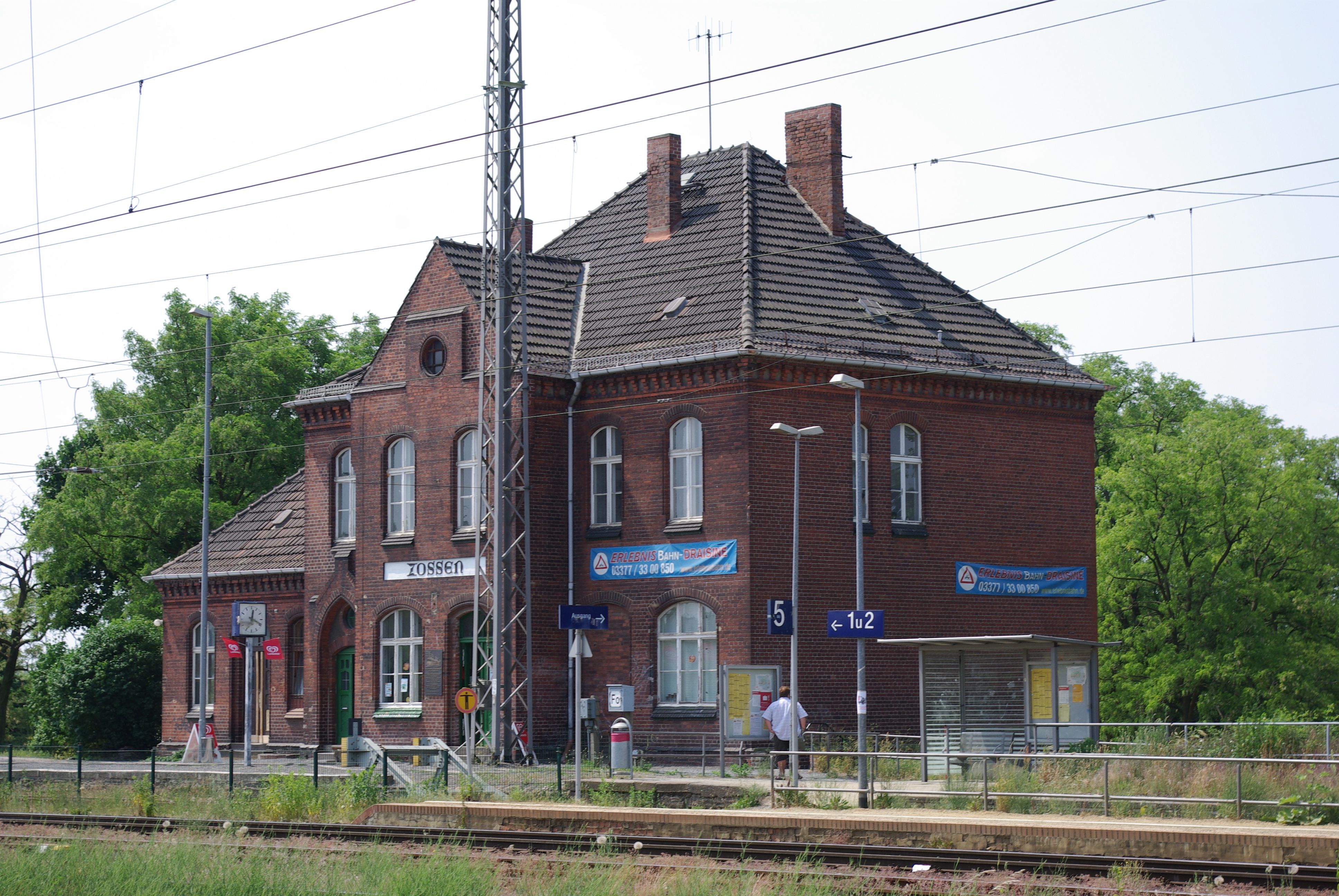
Zossen (; hsb, Sosny) is a German town in the district of Teltow-FlûÊming in Brandenburg, about south of Berlin, and next to the B96 highway. Zossen consists of several smaller municipalities, which were grouped together in 2003 to form the city. Geography Since the 2003 municipal reform, Zossen consists of the following districts and municipalities: History Zossen, like most places in Brandenburg, was originally a Slavic settlement. Its name (Upper Sorbian: ''Sosny'') may derive from ''Sosna'' meaning pine, a tree quite common in the region. In 1875, Zossen railway station opened on the railway line from Berlin to Dresden and the Prussian military railway to the artillery range at Kummersdorf-Gut in present-day Am Mellensee. Between 1901 and 1904, Zossen adopted the use of different high-speed vehicles, such as electric locomotives and trams, for transportation to and from Berlin-Marienfelde. These vehicles were powered by an alternating current of 15 kV and used a variable ... [...More Info...] [...Related Items...] OR: [Wikipedia] [Google] [Baidu] |
Trebbin
Trebbin (; Polish ''Trzebin''Thomas Kantzow "Pomerania", tom 1, Szczecin 2005, ) is a town in the Teltow-FlûÊming district of Brandenburg, Germany. It is situated on the river Nuthe, 14 km north of Luckenwalde, and 36 km southwest of Berlin (centre). Demography File:BevûÑlkerungsentwicklung Trebbin.pdf, Development of Population since 1875 within the Current Boundaries (Blue Line: Population; Dotted Line: Comparison to Population Development of Brandenburg state; Grey Background: Time of Nazi rule; Red Background: Time of Communist rule) File:BevûÑlkerungsprognosen Trebbin.pdf, Recent Population Development and Projections (Population Development before Census 2011 (blue line); Recent Population Development according to the Census in Germany in 2011 (blue bordered line); Official projections for 2005-2030 (yellow line); for 2017-2030 (scarlet line); for 2020-2030 (green line) Mayor Since 2003 the mayor is Thomas Berger (CDU). He was re-elected in September 2014. ... [...More Info...] [...Related Items...] OR: [Wikipedia] [Google] [Baidu] |
Jû¥terbog
Jû¥terbog () is a historic town in north-eastern Germany, in the Teltow-FlûÊming district of Brandenburg. It is on the Nuthe river at the northern slope of the FlûÊming hill range, about southwest of Berlin. History The Slavic settlement of ''Jutriboc'' in the Saxon Eastern March was first mentioned in 1007 by Thietmar of Merseburg, chronicler of Archbishop Tagino of Magdeburg. However, it was not incorporated into the Magdeburg diocese until 1157, when Archbishop Wichmann von Seeburg in the train of Albert the Bear established a burgward here. In 1170 Wichmann also founded the neighbouring Zinna Abbey and granted Jû¥terbog town privileges in 1174. The area remained a Magdeburg exclave between the Duchy of Saxe-Wittenberg and the Margraviate of Brandenburg throughout the Middle Ages. In March 1611 a treaty was signed in Jû¥terbog between Brandenburg and the Electorate of Saxony in a failed attempt to end the War of the Jû¥lich succession. In November 1644, during the Thirty ... [...More Info...] [...Related Items...] OR: [Wikipedia] [Google] [Baidu] |
Nuthe-Urstromtal
Nuthe-Urstromtal is a municipality in the Teltow-FlûÊming district of Brandenburg, Germany. By area, it is the largest rural municipality ("Gemeinde") in Germany. Demography File:BevûÑlkerungsentwicklung Nuthe-Urstromtal.pdf, Development of Population since 1875 within the Current Boundaries (Blue Line: Population; Dotted Line: Comparison to Population Development of Brandenburg state; Grey Background: Time of Nazi rule; Red Background: Time of Communist rule) File:BevûÑlkerungsprognosen Nuthe-Urstromtal.pdf, Recent Population Development and Projections (Population Development before Census 2011 (blue line); Recent Population Development according to the Census in Germany in 2011 (blue bordered line); Projection by the Brandenburg state for 2005-2030 (yellow line); Projection by the Brandenburg state for 2017-2030 (scarlet line); Projection by the Brandenburg state for 2020-2030 (green line) People * Rudi Dutschke Alfred Willi Rudolf "Rudi" Dutschke (; 7 March 1940 ã ... [...More Info...] [...Related Items...] OR: [Wikipedia] [Google] [Baidu] |


