|
Sundarbans
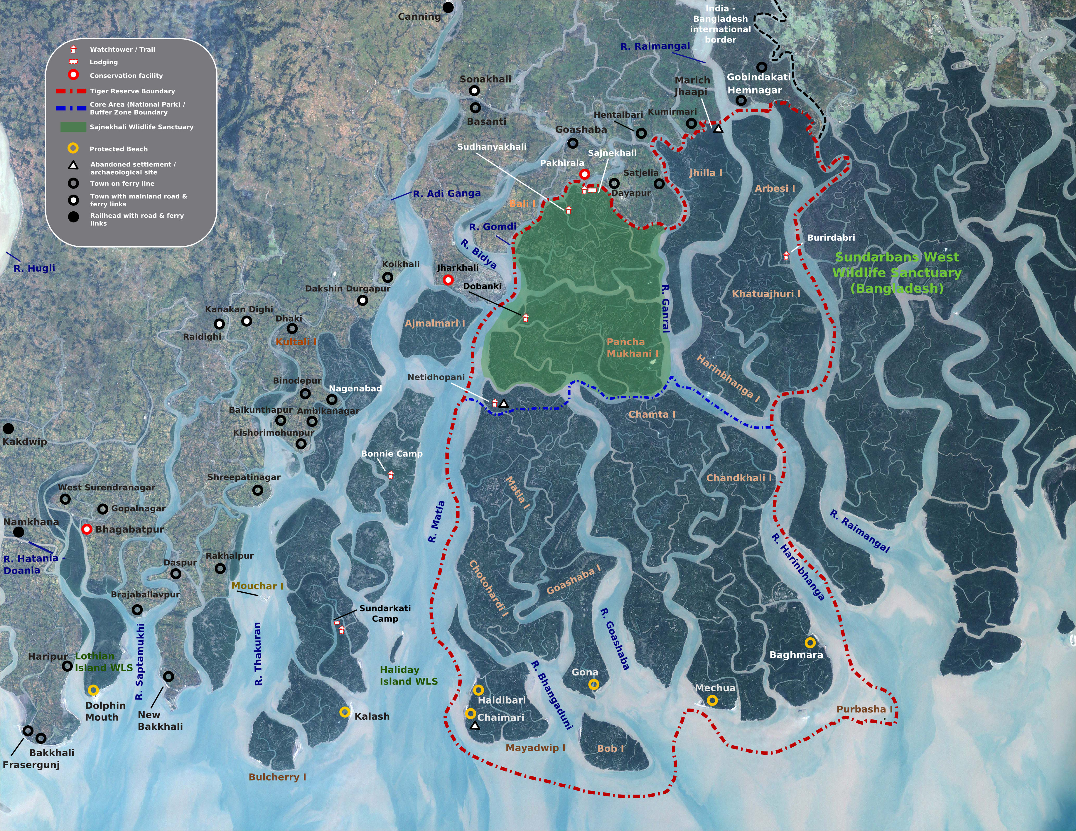
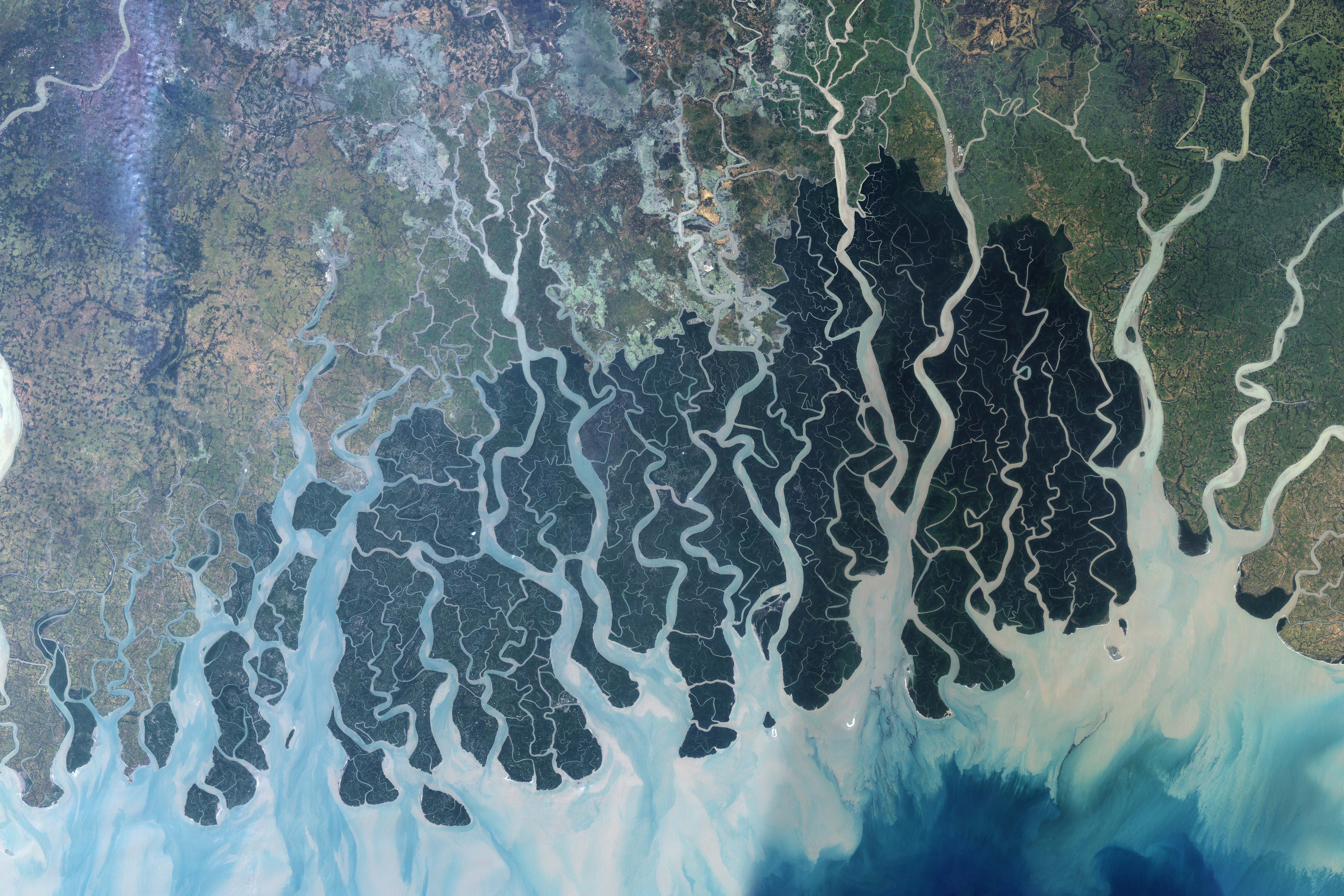
Sundarbans (pronounced ) is a mangrove area in the delta formed by the confluence of the Padma, Brahmaputra and Meghna Rivers in the Bay of Bengal. It spans the area from the Baleswar River in Bangladesh's division of Khulna to the Hooghly River in India's state of West Bengal. It comprises closed and open mangrove forests, land used for agricultural purpose, mudflats and barren land, and is intersected by multiple tidal streams and channels. Sundarbans is home to the world's largest area of mangrove forests. Four protected areas in the Sundarbans are enlisted as UNESCO World Heritage Sites, viz. Sundarbans West (Bangladesh), Sundarbans South (Bangladesh), Sundarbans East (Bangladesh) and Sundarbans National Park (India). Despite these protections, the Indian Sundarbans were considered endangered in a 2020 assessment under the IUCN Red List of Ecosystems framework. The Sundarbans mangrove forest covers an area of about , of which forests in Bangladesh's Khulna Division ex ... [...More Info...] [...Related Items...] OR: [Wikipedia] [Google] [Baidu] |
Sundarbans National Park
The Sundarbans National Park is a national park, tiger reserve and biosphere reserve in West Bengal, India. It is part of the Sundarbans on the Ganges Delta and adjacent to the Sundarban Reserve Forest in Bangladesh. It is located to south-west of the Bangladesh. The delta is densely covered by mangrove forests, and is one of the largest reserves for the Bengal tiger. It is also home to a variety of bird, reptile and invertebrate species, including the salt-water crocodile. The present Sundarban National Park was declared as the core area of Sundarban Tiger Reserve in 1973 and a wildlife sanctuary in 1977. On 4 May 1984 it was declared a national park. It is a UNESCO World Heritage Site inscribed in 1987, and it has been designated as a Ramsar site since 2019. It is considered as a World Network of Biosphere Reserve (Man and Biosphere Reserve) from 1989. The first forest management division to have jurisdiction over the Sundarbans was established in 1869. In 1875 a large por ... [...More Info...] [...Related Items...] OR: [Wikipedia] [Google] [Baidu] |
Sundarbans East Sanctuary
Sundarbans East Wildlife Sanctuary, a protected forest in Bangladesh, extends over an area of 31,227 ha. of mangrove forest. It was established in 1977 under the ''Bangladesh Wildlife (Preservation) (Amendment) Act, 1974'', having previously been a forest reserve. It is the most fertile of the three, non-adjoining wildlife sanctuaries established in the Sundarbans at that time, the others being the Sundarbans West Wildlife Sanctuary and the Sundarbans South Wildlife Sanctuary. The dominant mangrove species is "sundri" (''Heritiera fomes'') from which the Sundarbans region gets its name. Geography The Sundarbans East Wildlife Sanctuary is in a low-lying area of flat islands interspersed by a network of waterways. It is situated between the Katka and Supati Kals creeks in the Ganges Delta and is bounded to the south by the Bay of Bengal. The Baleshwari River supplies some freshwater but otherwise the waters are saline, being constantly replenished by the rise and fall of the tide. ... [...More Info...] [...Related Items...] OR: [Wikipedia] [Google] [Baidu] |
Sundarbans West Wildlife Sanctuary
Sundarbans West Wildlife Sanctuary is a UNESCO World Heritage Site and animal sanctuary in Bangladesh. The area of the reserve covers 715 km2. It is part of the larger Sundarbans region, one of the largest mangroveforests in the world. It is formed at the unified delta of the Ganges, Brahmaputra and Meghna rivers on the Bay of Bengal. The total area of the entire Sundarbans is about one million ha, 60% of which is found in Bangladesh, with the remainder 40% in India. The region is divided by the Raimangal River. Within the Bangladeshi area of Sundarbans, there are three wildlife sanctuaries: Sundarbans East, Sundarbans South, and Sundarbans West. Environment The region is intersected by a complex network of tidal waterways, mud flats and small islands of salt tolerant mangrove forests. The area is flooded with brackish water during high tides which mix with freshwater from inland rivers. Flora The region supports several mangroves, including: sparse stands of gewa (''Excoe ... [...More Info...] [...Related Items...] OR: [Wikipedia] [Google] [Baidu] |
Mangrove Forest
Mangrove forests, also called mangrove swamps, mangrove thickets or mangals, are productive wetlands that occur in coastal intertidal zones. Mangrove forests grow mainly at tropical and subtropical latitudes because mangroves cannot withstand freezing temperatures. There are about 80 different species of mangroves, all of which grow in areas with low-oxygen soil, where slow-moving waters allow fine sediments to accumulate.What is a mangrove forest? National Ocean Service, NOAA. Updated: 25 March 2021. Retrieved: 4 October 2021. Many mangrove forests can be recognised by their dense tangle of prop roots that make the trees appear to be standing on stilts above the water. This tangle of roots allows the trees to handle the daily rise and fall of tides, which means that most mangroves get flooded at least twice per day ... [...More Info...] [...Related Items...] OR: [Wikipedia] [Google] [Baidu] |
West Bengal
West Bengal (, Bengali: ''Poshchim Bongo'', , abbr. WB) is a state in the eastern portion of India. It is situated along the Bay of Bengal, along with a population of over 91 million inhabitants within an area of . West Bengal is the fourth-most populous and thirteenth-largest state by area in India, as well as the eighth-most populous country subdivision of the world. As a part of the Bengal region of the Indian subcontinent, it borders Bangladesh in the east, and Nepal and Bhutan in the north. It also borders the Indian states of Odisha, Jharkhand, Bihar, Sikkim and Assam. The state capital is Kolkata, the third-largest metropolis, and seventh largest city by population in India. West Bengal includes the Darjeeling Himalayan hill region, the Ganges delta, the Rarh region, the coastal Sundarbans and the Bay of Bengal. The state's main ethnic group are the Bengalis, with the Bengali Hindus forming the demographic majority. The area's early history featured a succession ... [...More Info...] [...Related Items...] OR: [Wikipedia] [Google] [Baidu] |
Bangladesh
Bangladesh (}, ), officially the People's Republic of Bangladesh, is a country in South Asia. It is the eighth-most populous country in the world, with a population exceeding 165 million people in an area of . Bangladesh is among the most densely populated countries in the world, and shares land borders with India to the west, north, and east, and Myanmar to the southeast; to the south it has a coastline along the Bay of Bengal. It is narrowly separated from Bhutan and Nepal by the Siliguri Corridor; and from China by the Indian state of Sikkim in the north. Dhaka, the capital and largest city, is the nation's political, financial and cultural centre. Chittagong, the second-largest city, is the busiest port on the Bay of Bengal. The official language is Bengali, one of the easternmost branches of the Indo-European language family. Bangladesh forms the sovereign part of the historic and ethnolinguistic region of Bengal, which was divided during the Partition of India in ... [...More Info...] [...Related Items...] OR: [Wikipedia] [Google] [Baidu] |
Khulna
Khulna ( bn, খুলনা, ) is the third-largest city in Bangladesh, after Dhaka and Chittagong. It is the administrative centre of Khulna District and Khulna Division. Khulna's economy is the third-largest in Bangladesh, contributing $53 billion in gross state product and $95 billion in purchasing power parity (PPP) in 2020. In the 2011 census, the city had a population of 663,342. Khulna is on the Rupsha and Bhairab Rivers. A centre of Bangladeshi industry, the city hosts many national companies. It is served by the Port of Mongla, Bangladesh's second-largest seaport. Khulna River Port is one of the country's oldest and busiest river ports. A colonial steamboat service, which includes the ''Tern'', ''Osrich'' and ''Lepcha'', operates on the river route to the city. Khulna is considered the gateway to the Sundarbans, the world's largest mangrove forest and home of the Bengal tiger. It is north of the Mosque City of Bagerhat, a UNESCO World Heritage Site. History Khulna w ... [...More Info...] [...Related Items...] OR: [Wikipedia] [Google] [Baidu] |
Bay Of Bengal
The Bay of Bengal is the northeastern part of the Indian Ocean, bounded on the west and northwest by India, on the north by Bangladesh, and on the east by Myanmar and the Andaman and Nicobar Islands of India. Its southern limit is a line between Sangaman Kanda, Sri Lanka, and the north westernmost point of Sumatra, Indonesia. It is the largest water region called a bay in the world. There are countries dependent on the Bay of Bengal in South Asia and Southeast Asia. During the existence of British India, it was named as the Bay of Bengal after the historic Bengal region. At the time, the Port of Kolkata served as the gateway to the Crown rule in India. Cox's Bazar, the longest sea beach in the world and Sundarbans, the largest mangrove forest and the natural habitat of the Bengal tiger, are located along the bay. The Bay of Bengal occupies an area of . A number of large rivers flow into the Bay of Bengal: the Ganges– Hooghly, the Padma, the Brahmaputra–Yamuna, the Barak� ... [...More Info...] [...Related Items...] OR: [Wikipedia] [Google] [Baidu] |
Sundarbans South Sanctuary
Sundarbans South Wildlife Sanctuary is a reserve forest in Bangladesh that extends over an area of 36,970 hectares of mangrove forest. It is situated next to the Sundarbans National Park in West Bengal, India. The sanctuary is one of three Sundarbans wildlife sanctuaries, the others being the Sundarbans East Wildlife Sanctuary and the Sundarbans West Wildlife Sanctuary. Flora The Gewa (Euphorbiaceae) tree is the dominant woody species in the Sanctuary. The other tree found abundantly is the Sundri (Heritiera fomes) tree. In areas where the Sundri tree does not regenerate effectively a dense understory is artificially created to enable growth. Environment Salinity Salinity () is the saltiness or amount of salt dissolved in a body of water, called saline water (see also soil salinity). It is usually measured in g/L or g/kg (grams of salt per liter/kilogram of water; the latter is dimensionless and equal ... levels vary greatly between seasons. This possibly represents a ... [...More Info...] [...Related Items...] OR: [Wikipedia] [Google] [Baidu] |
Khulna Division
The Khulna Division ( bn, খুলনা বিভাগ) is the second largest of the eight divisions of Bangladesh. It has an area of and a population of 15,563,000 at the 2011 Bangladesh census (preliminary returns). Its headquarters and largest city is Khulna city in Khulna District. History In British Raj Khulna Division was a part of Presidency division. Before 1947 The Presidency division had six major districts, Howrah, Calcutta, 24 Parganas, Khulna, undivided Jessore, & undivided Nadia. In 1947 The Partition of India is divided this division into two. The district of Khulna and the lion half of Jessore District and Nadia District become part of Newly established East Bengal. And rest of the district of the Presidency division become part of West Bengal. In 1948 The lion half Nadia district of East Bengal formed a new Kushtia District. And the govt of East Bengal added the Jessore , Khulna & Kushtia district into Rajshahi Division. After in 1960 the govt of East P ... [...More Info...] [...Related Items...] OR: [Wikipedia] [Google] [Baidu] |
Barguna
Barguna ( bn, বরগুনা) is a town in Barguna District, Barguna district in southern Bangladesh. It is the administrative headquarter and the largest town of Barguna district and a part of Barisal Division. Located on the bank of Khakdon river, the town covers an area of with a population of 33,098 as of the 2011 census. History Etymology There are different opinions about the origin of the name "Barguna". The general belief is that the name is derived from Bengali language, Bengali name "Baragun" meaning high tide. The remote past wood traders from the northern region had to wait here for Baragun (high tide) to pull their boats against strong current of the Khakdon river. While others say, Barguna was named after an eminent Magh people, Magh people who settled there at the very beginning of the habitation. As to the concept of history and folk, Barguna was named the official name likely in 1871, through the creation of a Patuakhali subdivision under then Bakerganj ... [...More Info...] [...Related Items...] OR: [Wikipedia] [Google] [Baidu] |
Basirhat
Basirhat is a city of West Bengal, India. It is located on the banks of the Ichamati (Ichhamati) River. Geography Location Basirhat is located at . Area overview The area shown in the map is a part of the Ichhamati-Raimangal Plain, located in the lower Ganges Delta. It contains soil of mature black or brownish loam to recent alluvium. Numerous rivers, creeks and ''khals'' criss-cross the area. The tip of the Sundarbans National Park is visible in the lower part of the map (shown in green but not marked). The larger full screen map shows the full forest area.A large section of the area is a part of the Sundarbans settlements.The densely populated area is an overwhelmingly rural area. Only 12.96% of the population lives in the urban areas and 87.04% of the population lives in the rural areas. Note: The map alongside presents some of the notable locations in the subdivision. All places marked in the map are linked in the larger full screen map. Civic administration Police st ... [...More Info...] [...Related Items...] OR: [Wikipedia] [Google] [Baidu] |


