|
Rukwa Region
Rukwa Region (''Mkoa wa Rukwa'' in Swahili) is one of Tanzania's 31 administrative regions with a postcode number 55000. The regional capital is the municipality of Sumbawanga. According to the 2012 national census, the region had a population of 1,004,539. For 2002–2012, the region's 3.2 percent average annual population growth rate was tied for the third highest in the country. It was also the twentieth most densely populated region with 44 people per square kilometer. The region is bordered to the north by the Katavi Region, to the east by the Mbeya Region, to the south by Zambia, and to the west by Lake Tanganyika, which forms a border between Tanzania and the Democratic Republic of the Congo. History The region's name comes from Lake Rukwa, which harbours the largest population of crocodiles in the nation. It is the region of the Fipa people, who maintain themselves by subsistence agriculture and livestock keeping. The Rukwa Region was established in 1975 by Presid ... [...More Info...] [...Related Items...] OR: [Wikipedia] [Google] [Baidu] |
Regions Of Tanzania
Tanzania is administratively divided into thirty-one regions ('' mkoa''). History * In 1975, Tanzania had 25 regions. In the 1970s, the name of the Ziwa Magharibi Region (West Lake Region) changed to Kagera Region. * In 2002, Manyara Region was created out of part of Arusha Region. * In 2012, four regions were created: Geita, Katavi, Njombe, and Simiyu. * In 2016, Songwe Region was created from the western part of Mbeya Region. List of regions Tanzania is subdivided into 31 regions (as of 2016). See also *Districts of Tanzania *List of regions of Tanzania by GDP This is a list of regions of Tanzania by GDP and GDP per capita. Data does only include values for Mainland Tansania without Zanzibar. List of regions by GDP Regions (2011 borders) by GDP in 2018 according to data by the National Bureau of Sta ... * ISO 3166-2:TZ Notes References {{Articles on first-level administrative divisions of African countries Subdivisions of Tanzania Tanzania, Regions T ... [...More Info...] [...Related Items...] OR: [Wikipedia] [Google] [Baidu] |
Mpanda District
Mpanda District is one of the five districts of the Katavi Region of Tanzania. Its administrative seat is the city of Mpanda. The district is bordered to the northwest by the Kigoma Region, to the northeast by the Tabora Region, to the east by the Mbeya Region, to the southeast by the Sumbawanga Urban District, to the southwest by the Nkasi District and to the west (for a small portion) by Lake Tanganyika. According to the 2002 Tanzania National Census, the population of the Mpanda District was 412,683. History Historically Mpanda District was part of Tabora, but in 1975 it was transferred into the newly created Rukwa Region. In 2012 Mpanda District was transferred into the Katavi Region. Mpanda owes its origins to the discovery of gold in 1934 by a very determined Belgian geologist and mining engineer called Jean de La Vallee Poussin. He obtained the concession and after then discovering a commercially viable deposit of lead and zinc, managed to develop the underground min ... [...More Info...] [...Related Items...] OR: [Wikipedia] [Google] [Baidu] |
Ruby
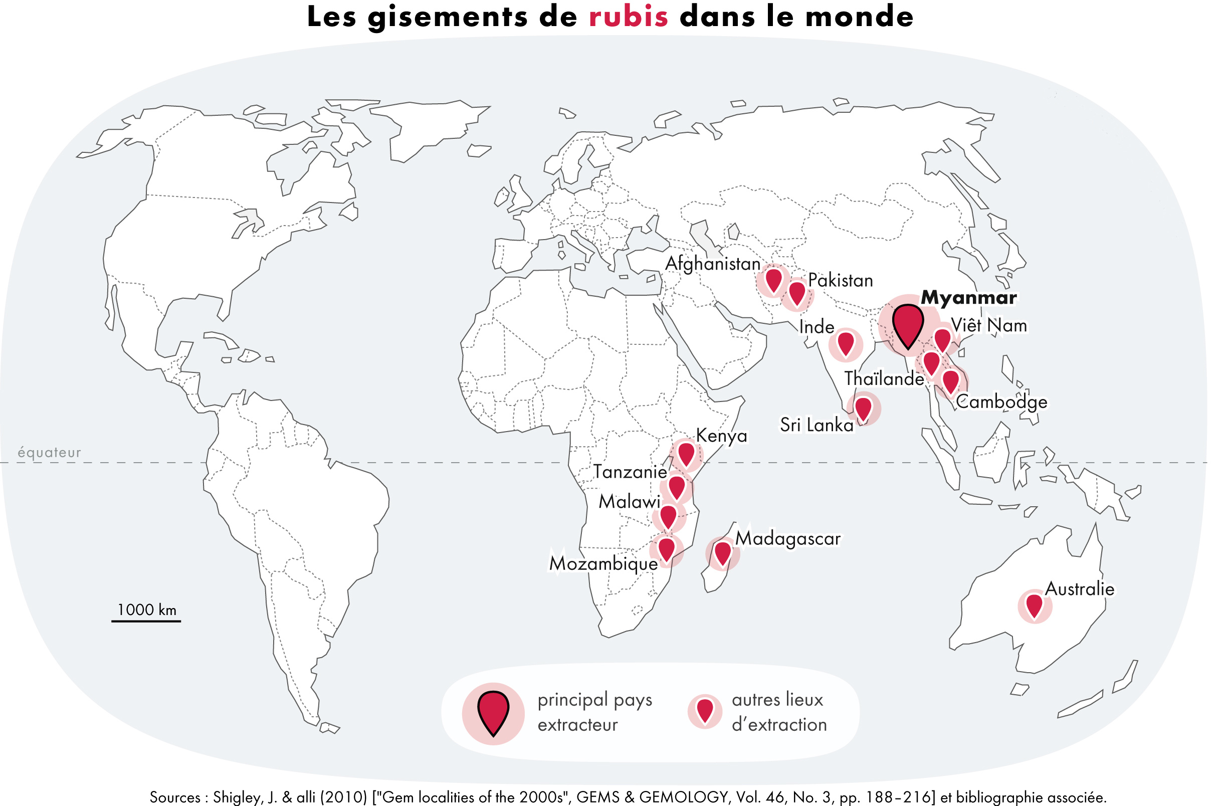
A ruby is a pinkish red to blood-red colored gemstone, a variety of the mineral corundum ( aluminium oxide). Ruby is one of the most popular traditional jewelry gems and is very durable. Other varieties of gem-quality corundum are called sapphires. Ruby is one of the traditional cardinal gems, alongside amethyst, sapphire, emerald, and diamond. The word ''ruby'' comes from ''ruber'', Latin for red. The color of a ruby is due to the element chromium. Some gemstones that are popularly or historically called rubies, such as the Black Prince's Ruby in the British Imperial State Crown, are actually spinels. These were once known as "Balas rubies". The quality of a ruby is determined by its color, cut, and clarity, which, along with carat weight, affect its value. The brightest and most valuable shade of red, called blood-red or pigeon blood, commands a large premium over other rubies of similar quality. After color follows clarity: similar to diamonds, a clear stone will com ... [...More Info...] [...Related Items...] OR: [Wikipedia] [Google] [Baidu] |
Amethyst
Amethyst is a violet variety of quartz. The name comes from the Koine Greek αμέθυστος ''amethystos'' from α- ''a-'', "not" and μεθύσκω (Ancient Greek) / μεθώ (Modern Greek), "intoxicate", a reference to the belief that the stone protected its owner from drunkenness. Ancient Greeks wore amethyst and carved drinking vessels from it in the belief that it would prevent intoxication. Amethyst, a semiprecious stone, is often used in jewelry and is the traditional birthstone for February. Structure Amethyst is a purple variety of quartz (SiO2) and owes its violet color to irradiation, impurities of iron and in some cases other transition metals, and the presence of other trace elements, which result in complex crystal lattice substitutions.Michael O'Donoghue (2006), ''Gems'', Butterworth-Heinemann, 6th ed. The hardness of the mineral is the same as quartz, thus making it suitable for use in jewelry. Hue and tone Amethyst occurs in primary hues from a li ... [...More Info...] [...Related Items...] OR: [Wikipedia] [Google] [Baidu] |
Beryl
Beryl ( ) is a mineral composed of beryllium aluminium silicate with the chemical formula Be3Al2Si6O18. Well-known varieties of beryl include emerald and aquamarine. Naturally occurring, hexagonal crystals of beryl can be up to several meters in size, but terminated crystals are relatively rare. Pure beryl is colorless, but it is frequently tinted by impurities; possible colors are green, blue, yellow, pink, and red (the rarest). It is an ore source of beryllium. Etymology The word ''beryl'' – enm, beril – is borrowed, via fro, beryl and la, beryllus, from Ancient Greek βήρυλλος ''bḗryllos'', which referred to a 'precious blue-green color-of-sea-water stone'; from Prakrit ''veruḷiya'', ''veḷuriya'' 'beryl' (compare the pseudo-Sanskritization वैडूर्य ''vaiḍūrya'' 'cat's eye; jewel; lapis lazuli', traditionally explained as '(brought) from (the city of) Vidūra'), which is ultimately of Dravidian origin, maybe from the name of Belur o ... [...More Info...] [...Related Items...] OR: [Wikipedia] [Google] [Baidu] |
Moonstone (gemstone)
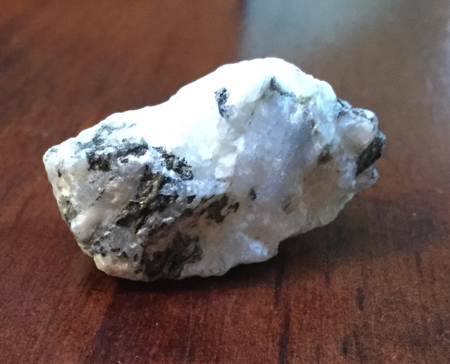
Moonstone is a sodium potassium aluminium silicate ((Na,K)AlSi3O8) of the feldspar group that displays a pearly and opalescent schiller. An alternative name is hecatolite. Etymology File:Pierrelune.jpg, Moonstone polished ''en cabochon'' The name ''moonstone'' derives from the stone's characteristic visual effect, called adularescence (or schiller), which produces a milky, bluish interior light. This effect is caused by light diffraction through alternating layers of orthoclast and albite within the stone. The diffracted light varies from white to blue, depending on the thinness of the albite layers. More technically, this micro-structure consists of regular exsolution layers (lamellae) of different alkali feldspars (orthoclase and sodium-rich plagioclase). Polished moonstones often display chatoyancy ("cat's eye" effect), where a luminous streak appears through the stone. Asterism is rare and produces four-legged stars. Geology The most common moonstone is of the orthocl ... [...More Info...] [...Related Items...] OR: [Wikipedia] [Google] [Baidu] |
Emerald
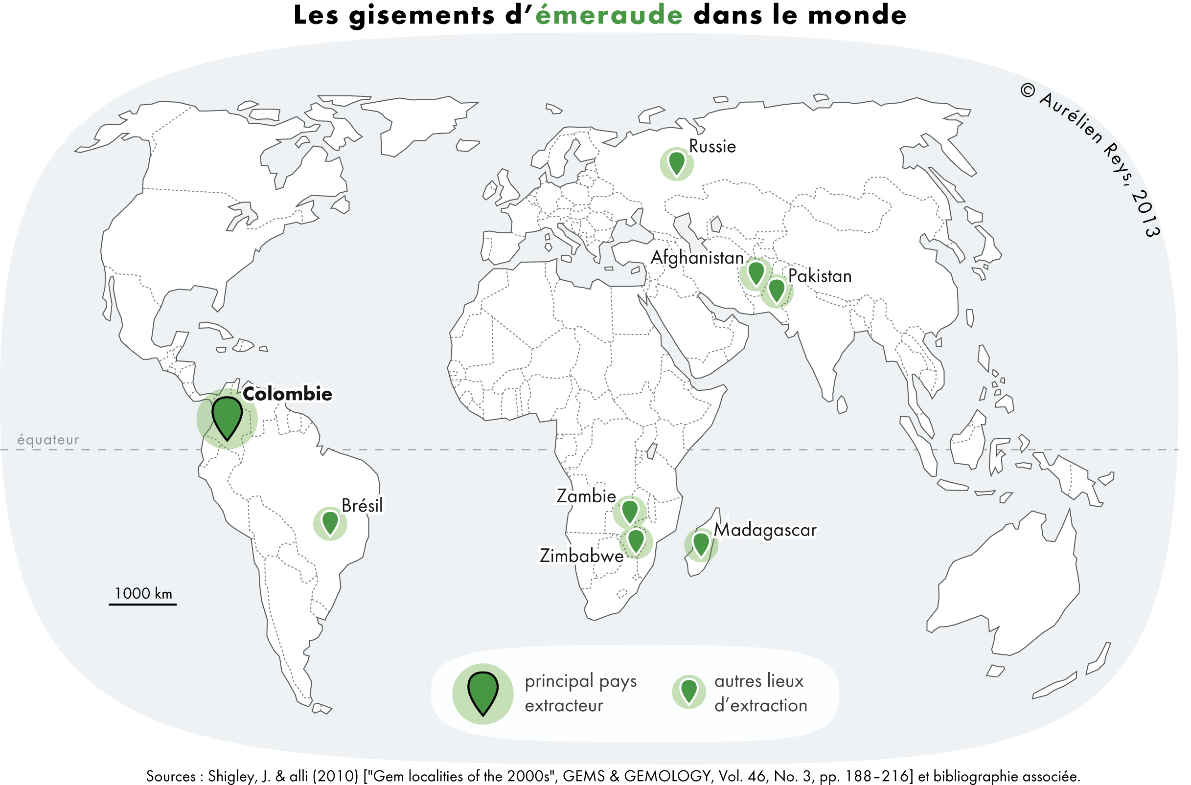
Emerald is a gemstone and a variety of the mineral beryl (Be3Al2(SiO3)6) colored green by trace amounts of chromium or sometimes vanadium.Hurlbut, Cornelius S. Jr. and Kammerling, Robert C. (1991) ''Gemology'', John Wiley & Sons, New York, p. 203, . Beryl has a hardness of 7.5–8 on the Mohs scale. Most emeralds are highly included, so their toughness (resistance to breakage) is classified as generally poor. Emerald is a cyclosilicate. Etymology The word "emerald" is derived (via fro, esmeraude and enm, emeraude), from Vulgar Latin: ''esmaralda''/''esmaraldus'', a variant of Latin ''smaragdus'', which was a via grc, σμάραγδος (smáragdos; "green gem") from a Semitic language. According to Webster's Dictionary the term emerald was first used in the 14th century. Properties determining value Emeralds, like all colored gemstones, are graded using four basic parameters–the four ''C''s of connoisseurship: ''color'', ''clarity,'' ''cut'' and ''carat weight''. N ... [...More Info...] [...Related Items...] OR: [Wikipedia] [Google] [Baidu] |
Sumbawanga District
Sumbawanga Urban District is one of the four districts in the Rukwa Region of Tanzania. It is bordered to the north by Lake Rukwa, to the east by the Mbeya Region, to the south by the Sumbawanga Rural District and to the west by the Nkasi District. The district (and regional) capital is Sumbawanga. According to the 2012 Tanzania National Census, the population of the Sumbawanga Urban District was 209,793. Wards The Sumbawanga Urban District is administratively divided into fifteen wards Ward may refer to: Division or unit * Hospital ward, a hospital division, floor, or room set aside for a particular class or group of patients, for example the psychiatric ward * Prison ward, a division of a penal institution such as a priso ...: Population of subdivisions in Sumbawanga Municipal #Chanji #Izi ... [...More Info...] [...Related Items...] OR: [Wikipedia] [Google] [Baidu] |
Nkasi District
Nkasi District (formerly Nkansi District) is one of the three districts of the Rukwa Region of Tanzania, with its headquarters in the village of Namanyere. It is bordered to the north by the Mpanda District of Katavi Region; to the east by the Sumbawanga District; to the south by the Sumbawanga Rural District and Zambia; and to the west by Lake Tanganyika across from the Democratic Republic of Congo. The district covers . , the population of the Nkasi District was 208,497. History Nkasi District was established on 1 January 1984. Economy Nkasi District is almost entirely rural, with well over 90% of its population undertaking subsistence farming, livestock rearing, and traditional fishing. Thirty-three of the villages in the district are located beside Lake Tanganyika. Major crops include: maize, millet, beans, and cassava ''Manihot esculenta'', commonly called cassava (), manioc, or yuca (among numerous regional names), is a woody shrub of the spurge family, Eu ... [...More Info...] [...Related Items...] OR: [Wikipedia] [Google] [Baidu] |


