|
Praia
Praia (, Portuguese language, Portuguese for "beach") is the capital and largest city of Cape Verde.Cape Verde, Statistical Yearbook 2015 Instituto Nacional de Estatística (Cape Verde), Instituto Nacional de Estatística Located on the southern coast of Santiago, Cape Verde, Santiago island, within the Sotavento Islands group, the city is the seat of the Praia, Cape Verde (municipality), Praia Municipality. Praia is the economic, political, and cultural center of Cape Verde. History  The island of Santiago was discovered by António da Noli in 1460.
 [...More Info...] [...Related Items...] OR: [Wikipedia] [Google] [Baidu] |
Plateau (Praia)
''Plateau'' is the historic centre of the capital city of Praia in the island of Santiago, Cape Verde. It gets its name (from French “plateau”) because it is situated on a plateau overlooking the port of Praia. Its average elevation is 37 meters above sea level. The population of ''Plateau'' was 1,019 at the 2010 census. Many public buildings are situated in ''Plateau'', notably the Presidential Palace, the cathedral, the city hall and the Ethnographic Museum. Adjacent neighbourhoods are Gamboa/Chã de Areia to the south, Várzea to the southwest and west, Achadinha to the northwest, Fazenda to the north and Praia Negra to the east. History Praia was founded as a small village near the natural harbour in the early 16th century. Due to its strategic position on a plateau it was easily defended against pirate attacks, which gave it a large advantage over the older city of Ribeira Grande (Cidade Velha). It gradually superseded Cidade Velha to become the most important set ... [...More Info...] [...Related Items...] OR: [Wikipedia] [Google] [Baidu] |
Santiago, Cape Verde
Santiago (Portuguese for “ Saint James”) is the largest island of Cape Verde, its most important agricultural centre and home to half the nation's population. Part of the Sotavento Islands, it lies between the islands of Maio ( to the east) and Fogo ( to the west). It was the first of the islands to be settled: the town of Ribeira Grande (now Cidade Velha and a UNESCO World Heritage Site) was founded in 1462. Santiago is home to the nation's capital city of Praia. History The eastern side of the nearby island of Fogo collapsed into the ocean 73,000 years ago, creating a tsunami 170 meters high which struck Santiago. In 1460, António de Noli became the first to visit the island. Da Noli settled at ''Ribeira Grande'' (now Cidade Velha) with his family members and Portuguese from Algarve and Alentejo in 1462.Valor simbóli ... [...More Info...] [...Related Items...] OR: [Wikipedia] [Google] [Baidu] |
Cape Verde
, national_anthem = () , official_languages = Portuguese , national_languages = Cape Verdean Creole , capital = Praia , coordinates = , largest_city = capital , demonym = Cape Verdean or Cabo Verdean , ethnic_groups_year = 2017 , government_type = Unitary semi-presidential republic , leader_title1 = President , leader_name1 = José Maria Neves , leader_title2 = Prime Minister , leader_name2 = Ulisses Correia e Silva , legislature = National Assembly , area_rank = 166th , area_km2 = 4033 , area_sq_mi = 1,557 , percent_water = negligible , population_census = 561,901 , population_census_rank = 172nd , population_census_year = 2021 , population_density_km2 = 123.7 , population_density_sq_mi = 325.0 , population_density_rank = 89th , GDP_PPP ... [...More Info...] [...Related Items...] OR: [Wikipedia] [Google] [Baidu] |
Praia Harbor
Praia Harbor ( pt, Porto da Praia) is the port of the city of Praia in the southern part of the island of Santiago, Cape Verde. It is situated in a natural bay of the Atlantic Ocean. Since the latest modernization in 2014, it has 2 long quays, 3 shorter quays, a quay for fishing boats with fish processing installations, 2 container parks, 2 roll-on/roll-off ramps and a passenger terminal. The total length of the quays is 863 m, and the maximum depth is 13.5 m. The port of Praia played an important role in the colonization of Africa and South America by the Portuguese. With 817,845 metric tonnes of cargo and 85,518 passengers handled (2017), it is the second busiest port of Cape Verde, after Porto Grande (Mindelo). The bay of Praia lies between the headlands Ponta Temerosa and Ponta das Bicudas. The islet Ilhéu de Santa Maria lies in the bay, west of the port. The river Ribeira da Trindade empties into the bay, between the city centre (Plateau) and the port. Directly north of t ... [...More Info...] [...Related Items...] OR: [Wikipedia] [Google] [Baidu] |
Praia, Cape Verde (municipality)
Praia is a ''concelho'' (municipality) of Cape Verde. It is situated in the southern part of the island of Santiago. Its seat is the city Praia, the capital of Cape Verde. Its area is , and its population was 131,719 at the 2010 census. The municipality consists of one ''freguesia'' (civil parish), Nossa Senhora da Graça. The city hall is located in the Platô part of the city. History Praia is one of the oldest municipalities in Cape Verde. It was created in the 18th century, when the then town of ''Praia de Santa Maria'' received town status and became the new capital of the Portuguese dominion of Cape Verde. Throughout history, its municipal territory has been successively reduced due to demographic increases. By the end of the 19th century, the Municipality of Praia occupied the southern half of the island, while the northern half was the (larger than present) Municipality of Santa Catarina. In 1971, the two northernmost parishes of the Municipality were split off to become ... [...More Info...] [...Related Items...] OR: [Wikipedia] [Google] [Baidu] |
Praia Harbour
Praia Harbor ( pt, Porto da Praia) is the port of the city of Praia in the southern part of the island of Santiago, Cape Verde. It is situated in a natural bay of the Atlantic Ocean. Since the latest modernization in 2014, it has 2 long quays, 3 shorter quays, a quay for fishing boats with fish processing installations, 2 container parks, 2 roll-on/roll-off ramps and a passenger terminal. The total length of the quays is 863 m, and the maximum depth is 13.5 m. The port of Praia played an important role in the colonization of Africa and South America by the Portuguese. With 817,845 metric tonnes of cargo and 85,518 passengers handled (2017), it is the second busiest port of Cape Verde, after Porto Grande (Mindelo). The bay of Praia lies between the headlands Ponta Temerosa and Ponta das Bicudas. The islet Ilhéu de Santa Maria lies in the bay, west of the port. The river Ribeira da Trindade empties into the bay, between the city centre (Plateau) and the port. Directly north of t ... [...More Info...] [...Related Items...] OR: [Wikipedia] [Google] [Baidu] |
University Of Cape Verde
The University of Cape Verde ( pt, Universidade de Cabo Verde, abbreviated "Uni-CVV") is the only public university of Cape Verde. The main campus is in Palmarejo, Praia, but there are also institutes in Mindelo, Assomada and São Jorge dos Órgãos. It has over 5000 students. A new campus for Uni-CV is under construction in Palmarejo, financed by the Chinese government. It should be completed by July 2020. It will have capacity for 4,890 students and 476 professors, with a library, dorms, cafeterias and sports facilities. It will have 61 class rooms, five auditoriums with a capacity of 150 seats, eight computer rooms, eight reading rooms and 34 laboratories. History The University of Cape Verde was created by decree-law 53/2006 of 20 November 2006 by merging of three colleges: * ISE (''Instituto Superior de Educação'', High Institute of Education) in Palmarejo, Praia, created under the decree-law 54/95 of October 2, 1995 * ISECMAR (''Instituto Superior de Engenharias e Ciênci ... [...More Info...] [...Related Items...] OR: [Wikipedia] [Google] [Baidu] |
Monumento De Diogo Gomes
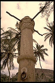
The Monumento de Diogo Gomes is a statue at the south end of the Plateau, the historic centre of Praia, on the island of Santiago, Cape Verde.Valor simbólico do centro histórico da Praia Lourenço Conceição Gomes, Universidade Portucalense, 2008 It represents , the navigator who was one of the discoverers of the island of Santiago in 1460. The cast iron statue was created by the Portuguese sculptor Joaquim Correia
[...More Info...] [...Related Items...] OR: [Wikipedia] [Google] [Baidu] |
Capture Of Santiago (1585)
The Capture of Santiago was a military engagement that took place between 11 and 28 November 1585 during the newly declared Anglo-Spanish War. (Santiago is the largest island of the Cape Verde archipelago.) An English expedition led by Francis Drake captured the port town of Cidade Velha in the Cape Verde islands that had recently belonged to the Crown of Portugal. He sacked it and then marched inland before doing the same at São Domingos and Praia. Afterwards Drake left and continued his expedition to successfully raid the Spanish possessions in the Americas.Bicheno 186-88 Background War had already been declared by Philip II of Spain after the Treaty of Nonsuch in which Elizabeth I had offered her support to the rebellious Protestant Dutch rebels. The Queen through Francis Walsingham ordered Sir Francis Drake to lead an expedition to attack the Spanish New World in a kind of preemptive strike.Mancall p. 166-67 Expedition The expedition gathered at Plymouth on 14 Septem ... [...More Info...] [...Related Items...] OR: [Wikipedia] [Google] [Baidu] |
Administrative Divisions Of Cape Verde
The territory of Cape Verde is divided into 22 ''concelhos'' (municipalities), and subdivided into 32 ''freguesias'' (equivalent to civil parish). In Portuguese language usage, there are two words to distinguish the territory and the administrative organ. Administratively, right below the government, there are the ''municípios'' (municipalities), who administrate the ''concelhos''. Therefore, the ''concelhos'' are the first-level administrative subdivision in Cape Verde. Each municipality has an ''Assembleia Municipal'' (municipal assembly, the legislative body) and a ''Câmara Municipal'' (municipal chamber, the executive body). Every four years elections are held for the Assembleia Municipal, the Câmara Municipal and the President of the Câmara Municipal. Where a municipality consists of several ''freguesias'' (civil parishes), a ''Delegação Municipal'' (municipal delegation) is established in the parishes that do not contain the municipal seat. The islands are traditionall ... [...More Info...] [...Related Items...] OR: [Wikipedia] [Google] [Baidu] |
Cidade Velha
Cidade Velha (Portuguese for "old city", also: ''Santiago de Cabo Verde'') is a cityCabo Verde, Statistical Yearbook 2015 Instituto Nacional de Estatística, p. 32-33 in the southern part of the island of , . Founded in 1462, [...More Info...] [...Related Items...] OR: [Wikipedia] [Google] [Baidu] |
Battle Of Porto Praya
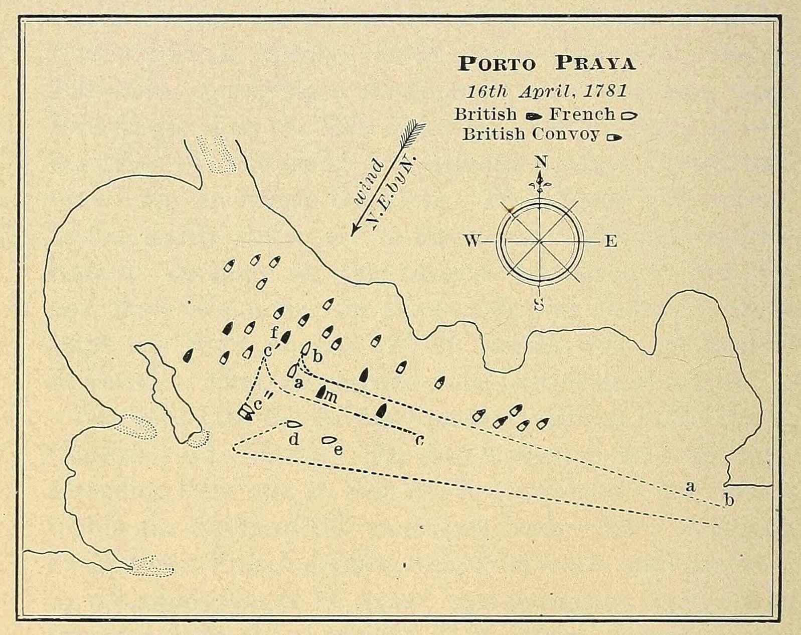
The Battle of Porto Praya was a naval battle that took place during the American Revolutionary War on 16 April 1781 between a British squadron under Commodore George Johnstone and a French squadron under the Bailli de Suffren. Both squadrons were en route to the Cape of Good Hope, the British to take it from the Dutch, the French aiming to help defend it and French possessions in the Indian Ocean. The British convoy and its escorting squadron had anchored at Porto Praya (now Praia) in the Portuguese Cape Verde Islands to take on water, when the French squadron arrived and attacked them at anchor. Due to the unexpected nature of the encounter, neither fleet was prepared to do battle, and in the inconclusive battle the French fleet sustained more damage than the British, though no ships were lost. Johnstone tried to pursue the French, but was forced to call it off in order to repair the damage his ships had taken. The French gained a strategic victory, because Suffren beat John ... [...More Info...] [...Related Items...] OR: [Wikipedia] [Google] [Baidu] |


_p098_PORTO_PRAYA%2C_ISLAND_OF_ST.JAGO.jpg)

