|
Pilling
Pilling is a village and civil parish within the Borough of Wyre, Wyre borough of Lancashire, England. It is north-northeast of Poulton-le-Fylde, south-southwest of Lancaster, Lancashire, Lancaster and northwest of Preston, Lancashire, Preston, in a part of the Fylde known as Over Wyre. The civil parish of Pilling, which includes the localities of Stake Pool, Scronkey and Eagland Hill, had a total resident population of 1,739 in 2001, increasing to 2,020 at the 2011 Census. Populations in the 19th century ranged from 1,281 in 1851 to 1,572 in 1871. Etymology Eilert Ekwall suggests the name is Common Brittonic, Celtic, linking it with the Welsh toponymy, Welsh place-name element Pil (placename), "Pîl" (rendered as Pyl in Old English). This etymology would suggest the settlement started as a tidal inlet used as a harbour. Ekwall suggested the geography of Pilling may be "accurately described as a pill". The name appears as ''Pylin'' in 1246 and, if the name is indeed Celt ... [...More Info...] [...Related Items...] OR: [Wikipedia] [Google] [Baidu] |
St John The Baptist's Church, Pilling
St John the Baptist's Church is in the village of Pilling, Lancashire, England. It is an active Anglican parish church in the deanery of Garstang, the archdeaconry of Lancaster and the diocese of Blackburn. The church is recorded in the National Heritage List for England as a designated Grade II* listed building. Its benefice is combined with those of St James, Stalmine, and St Mark, Eagland Hill. It is described as "a fine example of the late Gothic Revival church with much originality in detail". History The church was built in 1886–87 to replace the older Church of St John the Baptist on a site some to the north of the old church. It was designed by the Lancaster firm of Paley and Austin at a cost of £7,000 (), and provided seating for 410 people. Commenting on the church, the architectural historian Nikolaus Pevsner wrote "The fertility of Paley & Austin remains astonishing". In 1919–20 Henry Paley, of the same architectural practice, desig ... [...More Info...] [...Related Items...] OR: [Wikipedia] [Google] [Baidu] |
The Garstang And Knott End Railway
The was a railway line, between Garstang and Pilling, across the Fylde of Lancashire, England. It was built by local agricultural interests to develop unproductive land. It had been intended to continue to Knott End but ran out of money. It eventually opened in 1870. In 1898 the Knott End Railway (KER) was authorised to continue to Knott End; it opened in 1908. The two companies were associated and the KER acquired the earlier company. The KER was still desperately short of money, and local people who were owed money bought rolling stock to keep the company going. Salt extraction near Preesall became a dominant industry from 1890, and the railway conveyed some remarkable tonnages of salt (outward) and coal (inward, for power). The passenger service was discontinued in 1930 and the line closed completely in 1965. Authorisation In the mid-nineteenth century, the tract of land to the west of Garstang, in the Fylde area of Lancashire, was an unworked expanse of moss. Attempts were ... [...More Info...] [...Related Items...] OR: [Wikipedia] [Google] [Baidu] |
Damside Windmill
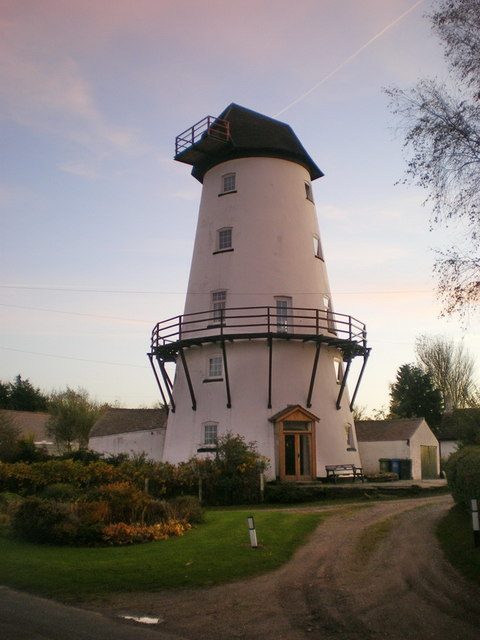
Damside Windmill (also known as Pilling Windmill and The Old Mill) is a tower windmill in the English village of Pilling, Lancashire. It was built in 1808 by Ralph Slater, builder of similar structures in the area, such as Marsh Mill. An earlier mill was marked here on Yates's 1786 map of Lancashire.''The industrial archaeology of north-west England'', Owen Ashmore (1982), p. 216 The mill converted to steam power in 1870, and the sails were removed in 1887. It continued to operate until the 1920s, after which it fell into disrepair. By 1975, the mill had been restored for use as a private residence. The top of the windmill was restored with a traditional wooden cap in 2007, restoring it to its original height of .A Short History of Pilling Windmill : 1808–2007 accessed 16 October 2011 Invent ... [...More Info...] [...Related Items...] OR: [Wikipedia] [Google] [Baidu] |
Preesall
Preesall is a town, civil parish and electoral ward in Lancashire, England. The parish (until 1910 known as Preesall with Hackensall) covers the eastern bank of the estuary of the River Wyre, including Knott End-on-Sea, Pilling Lane and the village of Preesall itself. The parish of Preesall had a population of 5,314 recorded in the 2001 census, rising to 5,694 at the 2011 census. History There is evidence that the eastern side of the River Wyre was occupied during the Danish invasions of the 9th and 10th centuries. Preesall is mentioned in the Domesday Book (1086) as being a part of the Hundred of Amounderness and the Domesday place name is given as ''Pressouede''. The names Preesall and Hackensall are both probably Norse in origin, with Preesall meaning "a hill and a heath" and Hackensall probably deriving from "Haakon", a Viking seafarer who sailed up the River Wyre and set up an encampment in the 10th century. In 1190 the land was granted to a bowman in the service of Pr ... [...More Info...] [...Related Items...] OR: [Wikipedia] [Google] [Baidu] |
Eagland Hill
Eagland Hill is a rural hamlet in the civil parish of Pilling, in the county of Lancashire, England. It lies in a part of the Fylde, west of Garstang, known locally as Over Wyre. The church, dedicated to St Mark, dates from 1870. The area attracts many bird-watchers, due to the number of rare birds. St Mark's Church The church's foundation stone was laid, on 13 August 1869, by co-founder James Jenkinson and the church was opened on St Mark's Day, 20 April, in the following year. Jenkinson's cottage was the first house to be built in the village, in 1814, and the church altar is located where the cottage fireplace once stood. The church does not have a graveyard. The family history of James Jenkinson has been extensively researched. "Owd Jemmy" was born in 1786 in Kirkland. He married Ellen Fisher on 6 June 1808, at St Helen's Church, Churchtown, and with her had fourteen children. He died in 1874 at Birks Farm, Eagland Hill, and was buried at St John the Baptist's Church, ... [...More Info...] [...Related Items...] OR: [Wikipedia] [Google] [Baidu] |
Scronkey
Scronkey is a small rural hamlet in the county of Lancashire, England. It is on the Over Wyre region of the Fylde, west of Garstang near Pilling. The combined population of Scronkey and Eagland Hill Eagland Hill is a rural hamlet in the civil parish of Pilling, in the county of Lancashire, England. It lies in a part of the Fylde, west of Garstang, known locally as Over Wyre. The church, dedicated to St Mark, dates from 1870. The area attra ... was 272 in 2001. References Villages in Lancashire Pilling The Fylde {{Lancashire-geo-stub ... [...More Info...] [...Related Items...] OR: [Wikipedia] [Google] [Baidu] |
Over Wyre
Over Wyre is the collective name given to a group of villages in Lancashire, England, situated on the Fylde, to the north and east of the River Wyre. The group is usually considered to include Hambleton, Stalmine, Knott End-on-Sea, Preesall, Pilling and Out Rawcliffe. The name distinguishes these villages from the larger southern part of the Fylde, between the Wyre and the Ribble, which includes the urban areas of Blackpool, Poulton-le-Fylde, Thornton, Cleveleys, Fleetwood and Lytham St Annes Lytham St Annes () is a seaside town in the Borough of Fylde in Lancashire, England. It is on the The Fylde, Fylde coast, directly south of Blackpool on the Ribble Estuary. The population at the United Kingdom Census 2011, 2011 census was 42,954 .... External links Over-Wyre and Knott End History and Topography Geography of the Borough of Wyre The Fylde {{Lancashire-geo-stub ... [...More Info...] [...Related Items...] OR: [Wikipedia] [Google] [Baidu] |
The Fylde
The Fylde () is a coastal plain in western Lancashire, England. It is roughly a square-shaped peninsula, bounded by Morecambe Bay to the north, the Ribble estuary to the south, the Irish Sea to the west, and the foot of the Bowland hills to the east which approximates to a section of the M6 motorway and West Coast Main Line. Geography It is a flat, alluvial plain, parts of which have deposits of and were once dug for peat. The River Wyre meanders across the Fylde from Garstang on the eastern edge, westwards towards Poulton and then northwards to the sea at Fleetwood. The area north and east of the tidal Wyre, known as Over Wyre, is the more rural side of the river. The Fylde is roughly trisected by the M55 motorway and A586 road. The west coast is almost entirely urban, containing the towns of Fleetwood, Cleveleys, Blackpool, St Annes and Lytham; with Thornton, Carleton and Poulton-le-Fylde not far inland. This area forms the Blackpool Urban Area. The central souther ... [...More Info...] [...Related Items...] OR: [Wikipedia] [Google] [Baidu] |
Borough Of Wyre
Wyre is a local government district with borough status in Lancashire, England. The population of the non-metropolitan district at the 2011 census was 107,749. The district borders the unitary authority area of Blackpool as well as the districts of Lancaster, Ribble Valley, Fylde and Preston. The council is based in Poulton-le-Fylde. The district is named after the River Wyre, which runs through the district. The district is a rare contemporary example of a non-contiguous local government area. There are no road or rail connections between the parts of the borough divided by the River Wyre, and it is necessary to travel through the Fylde district in order to travel between the two divided parts of Wyre, or else use the passenger ferry between Fleetwood and Knott End. The borough also includes parts of Blackpool built-up area. History The district was created on 1 April 1974 under the Local Government Act 1972, as a non-metropolitan district covering the territory of fi ... [...More Info...] [...Related Items...] OR: [Wikipedia] [Google] [Baidu] |
Morecambe Bay
Morecambe Bay is a large estuary in northwest England, just to the south of the Lake District National Park. It is the largest expanse of intertidal mudflats and sand in the United Kingdom, covering a total area of . In 1974, the second largest gas field in the UK was discovered west of Blackpool, with original reserves of over 7 trillion cubic feet (tcf) (200 billion cubic metres). At its peak, 15% of Britain's gas supply came from the bay but production is now in decline. It is also one of the homes of the high brown fritillary butterfly. Natural features The rivers Leven, Kent, Keer, Lune and Wyre drain into the Bay, with their various estuaries making a number of peninsulas within the bay. Much of the land around the bay is reclaimed, forming salt marshes used in agriculture. Morecambe Bay is also an important wildlife site, with abundant birdlife and varied marine habitats, and there is a bird observatory at Walney Island. The bay has rich cockle beds, which have been ... [...More Info...] [...Related Items...] OR: [Wikipedia] [Google] [Baidu] |
Lancaster, Lancashire
Lancaster (, ) is a city and the county town of Lancashire, England, standing on the River Lune. Its population of 52,234 compares with one of 138,375 in the wider City of Lancaster local government district. The House of Lancaster was a branch of the English royal family. The Duchy of Lancaster still holds large estates on behalf of Charles III, who is also Duke of Lancaster. Its long history is marked by Lancaster Castle, Lancaster Priory Church, Lancaster Cathedral and the Ashton Memorial. It is the seat of Lancaster University and has a campus of the University of Cumbria. The Port of Lancaster played a big role in the city's growth, but for many years the outport of Glasson Dock has become the main shipping facility. History The name of the city first appeared in the Domesday Book of 1086, as ''Loncastre'', where "Lon" refers to the River Lune and "castre" (from the Old English ''cæster'' and Latin ''castrum'' for "fort") to the Roman fort that stood on the site. Ro ... [...More Info...] [...Related Items...] OR: [Wikipedia] [Google] [Baidu] |
Lancaster And Fleetwood (UK Parliament Constituency)
Lancaster and Fleetwood is a constituency created in 2010 represented in the House of Commons of the UK Parliament by Cat Smith of the Labour Party. History ;Creation Following their review of parliamentary representation in Lancashire, the Boundary Commission created a new Wyre and Preston North constituency, fought at the 2010 general election, which split the previous linking of Lancaster and Wyre. As a consequence, Lancaster and the coastal town of Fleetwood have been attached for parliamentary purposes. ;Summary of results to date In 2010 the winning candidate was Eric Ollerenshaw, a Conservative. He was defeated in the 2015 general election by Labour's Cat Smith. The 2015 result gave the seat the 16th-smallest majority of Labour's 232 seats by percentage of majority. Ollerenshaw attempted to regain the seat at the 2017 general election but was again defeated by Smith, who significantly increased her majority to over 6,500. At the 2019 General election Smith's majorit ... [...More Info...] [...Related Items...] OR: [Wikipedia] [Google] [Baidu] |


