|
Physiographic Regions Of The United States
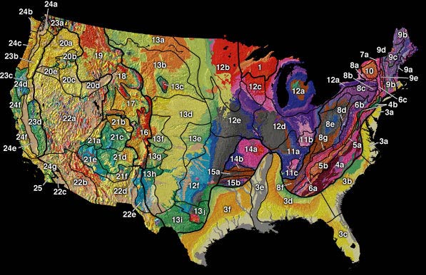
The physiographic regions of the contiguous United States The contiguous United States (officially the conterminous United States) consists of the 48 adjoining U.S. states and the Federal District of the United States of America. The term excludes the only two non-contiguous states, Alaska and Hawaii ... comprise 8 regions, 25 provinces, and 85 sections. The system dates to Nevin Fenneman's paper ''Physiographic Subdivision of the United States'', published in 1917. Fenneman expanded and presented his system more fully in two books, ''Physiography of western United States'' (1931), and ''Physiography of eastern United States'' (1938). In these works Fenneman described 25 provinces and 85 sections of the United States physiography. Physiographic divisions References {{DEFAULTSORT:United States Physiographic Region ... [...More Info...] [...Related Items...] OR: [Wikipedia] [Google] [Baidu] |
US Physiographic Regions Map
The United States of America (U.S.A. or USA), commonly known as the United States (U.S. or US) or America, is a country Continental United States, primarily located in North America. It consists of 50 U.S. state, states, a Washington, D.C., federal district, five major unincorporated territories, nine United States Minor Outlying Islands, Minor Outlying Islands, and 326 Indian reservations. The United States is also in Compact of Free Association, free association with three Oceania, Pacific Island Sovereign state, sovereign states: the Federated States of Micronesia, the Marshall Islands, and the Palau, Republic of Palau. It is the world's List of countries and dependencies by area, third-largest country by both land and total area. It shares land borders Canada–United States border, with Canada to its north and Mexico–United States border, with Mexico to its south and has maritime borders with the Bahamas, Cuba, Russia, and other nations. With a population of over 333 m ... [...More Info...] [...Related Items...] OR: [Wikipedia] [Google] [Baidu] |
Blue Ridge Mountains
The Blue Ridge Mountains are a physiographic province of the larger Appalachian Mountains range. The mountain range is located in the Eastern United States, and extends 550 miles southwest from southern Pennsylvania through Maryland, West Virginia, Virginia, North Carolina, South Carolina, Tennessee, and Georgia. This province consists of northern and southern physiographic regions, which divide near the Roanoke River gap. To the west of the Blue Ridge, between it and the bulk of the Appalachians, lies the Great Appalachian Valley, bordered on the west by the Ridge and Valley province of the Appalachian range. The Blue Ridge Mountains are known for having a bluish color when seen from a distance. Trees put the "blue" in Blue Ridge, from the isoprene released into the atmosphere. This contributes to the characteristic haze on the mountains and their perceived color. Within the Blue Ridge province are two major national parks – the Shenandoah National Park in the northern secti ... [...More Info...] [...Related Items...] OR: [Wikipedia] [Google] [Baidu] |
White Mountains (New Hampshire)
The White Mountains are a mountain range covering about a quarter of the state of New Hampshire and a small portion of western Maine in the United States. They are part of the northern Appalachian Mountains and the most rugged mountains in New England. The range is heavily visited due to its proximity to Boston, New York City, and Montreal. Most of the area is public land, including the White Mountain National Forest and a number of state parks. Its most famous mountain is Mount Washington, which is the highest peak in the Northeastern U.S. and for 76 years held the record for fastest surface wind gust in the world ( in 1934). Mount Washington is part of a line of summits, the Presidential Range, that are named after U.S. presidents and other prominent Americans. The White Mountains also include the Franconia Range, Sandwich Range, Carter-Moriah Range and Kinsman Range in New Hampshire, and the Mahoosuc Range straddling the border between it and Maine. In all, there are 48 peak ... [...More Info...] [...Related Items...] OR: [Wikipedia] [Google] [Baidu] |
New England Uplands
The topography of the New England Uplands section is that of a maturely-dissected plateau with narrow valleys, and the entire area is greatly modified by glaciation. It is the most widespread of the geomorphic sections in the New England Province, extending from Canada through New England down to the Seaboard section and extending southwestward through New York and New Jersey as two narrow upland projections, the Reading Prong and the Manhattan Prong. Numerous hills and mountains rise above the general level of the upland; except in the presence of mountains, the horizon of the regional landscape is fairly level. Glaciation has resulted in the erosion and rounding off of the bedrock topography and numerous rock basin lakes. Glacial drift is thin, patchy, and stony, and ice-contact features such as kames, kame terraces, and eskers are abundant. The surface of the New England Uplands slopes southeast from maximum inland altitudes around , excluding the other mountainous sections of the ... [...More Info...] [...Related Items...] OR: [Wikipedia] [Google] [Baidu] |
New England Seaboard
In geology, the New England Seaboard (Lowland) is a physiographic section of the New England province. It includes a thin section of coastal Connecticut, most of Rhode Island, and roughly the coastal counties of Massachusetts, New Hampshire, and Maine. It does not include Long Island, Cape Cod, Martha's Vineyard, Nantucket, the Elizabeth Islands, and smaller islands, which are part of the Outer Lands, a partly submerged extension of the Atlantic coastal plain. The Seaboard Lowland section is bounded to the northwest by the New England Uplands The topography of the New England Uplands section is that of a maturely-dissected plateau with narrow valleys, and the entire area is greatly modified by glaciation. It is the most widespread of the geomorphic sections in the New England Province, e ..., and to the southwest by the Atlantic Ocean. References {{geology-stub Physiographic sections Landforms of Maine Landforms of New Hampshire Landforms of Massachusetts Landforms of Rhode ... [...More Info...] [...Related Items...] OR: [Wikipedia] [Google] [Baidu] |
New England Province
The New England province is a physiographic province of the larger Appalachian division of eastern North America. The province consists of the Seaboard Lowland, New England Upland, White Mountain, Green Mountain, and Taconic sections. Geology Much of the New England province's bedrock aquifers are in consolidated rocks of sedimentary, igneous, and metamorphic origin. Some of these aquifers, mainly in the western portion of Vermont, consist of carbonate rocks (primarily limestone, dolomite, and marble). These consolidated rocks yield water primarily from bedding planes, fractures, joints, and faults, rather than from intergranular pores. Like the adjacent physiographic provinces, a large part of the New England province was peneplained during the Jurassic and Cretaceous The Cretaceous ( ) is a geological period that lasted from about 145 to 66 million years ago (Mya). It is the third and final period of the Mesozoic Era, as well as the longest. At around 79 million years, it ... [...More Info...] [...Related Items...] OR: [Wikipedia] [Google] [Baidu] |
Cumberland Mountains
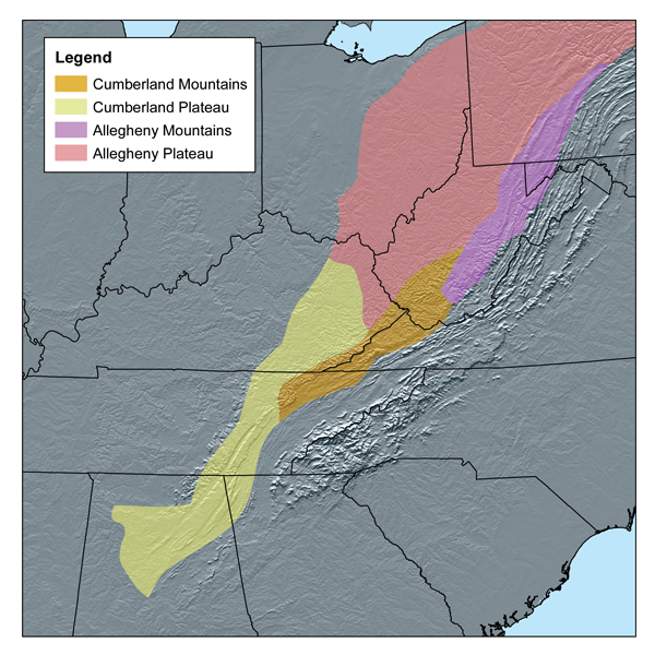
The Cumberland Mountains are a mountain range in the southeastern section of the Appalachian Mountains. They are located in western Virginia, southwestern West Virginia, the eastern edges of Kentucky, and eastern middle Tennessee, including the Crab Orchard Mountains. Their highest peak, with an elevation of above mean sea level, is High Knob, which is located near Norton, Virginia. According to the USGS, the Cumberland Mountain range is long and wide, bounded by the Russell Fork on the northeast, the Pound River and Powell River on the southeast, Cove Creek on the southwest, and Tackett Creek, the Cumberland River, Poor Fork Cumberland River, and Elkhorn Creek on the northwest. The crest of the range forms the Kentucky and Virginia boundary from the Tennessee border to the Russell Fork River. Variant names of the Cumberland Mountains include Cumberland Mountain, Cumberland Range, Ouasioto Mountains, Ouasiota Mountains, Laurel Mountain, and Pine Mountain. They are name ... [...More Info...] [...Related Items...] OR: [Wikipedia] [Google] [Baidu] |
Cumberland Plateau
The Cumberland Plateau is the southern part of the Appalachian Plateau in the Appalachian Mountains of the United States. It includes much of eastern Kentucky and Tennessee, and portions of northern Alabama and northwest Georgia. The terms "Allegheny Plateau" and the "Cumberland Plateau" both refer to the dissected plateau lands lying west of the main Appalachian Mountains. The terms stem from historical usage rather than geological difference, so there is no strict dividing line between the two. Two major rivers share the names of the plateaus, with the Allegheny River rising in the Allegheny Plateau and the Cumberland River rising in the Cumberland Plateau in Harlan County, Kentucky. Geography The Cumberland Plateau is a deeply dissected plateau, with topographic relief commonly of about , and frequent sandstone outcroppings and bluffs. At Kentucky's Pottsville Escarpment, which is the transition from the Cumberland Plateau to the Bluegrass in the north and the Pennyril ... [...More Info...] [...Related Items...] OR: [Wikipedia] [Google] [Baidu] |
Allegheny Plateau
The Allegheny Plateau , in the United States, is a large dissected plateau area of the Appalachian Mountains in western and central New York, northern and western Pennsylvania, northern and western West Virginia, and eastern Ohio. It is divided into the unglaciated Allegheny Plateau and the glaciated Allegheny Plateau. The plateau extends southward into western West Virginia, eastern Kentucky and Tennessee where it is instead called the Cumberland Plateau. The plateau terminates in the east at the Allegheny Mountains, which are the highest ridges just west of the Allegheny Front. The Front extends from central Pennsylvania through Maryland and into eastern West Virginia. The plateau is bordered on the west by glacial till plains in the north, generally north of the Ohio River, and the Bluegrass region in the south, generally south of the Ohio River. Elevations vary greatly. In the glaciated Allegheny Plateau, relief may only reach one hundred feet or less. In the unglacia ... [...More Info...] [...Related Items...] OR: [Wikipedia] [Google] [Baidu] |
Catskill Mountains
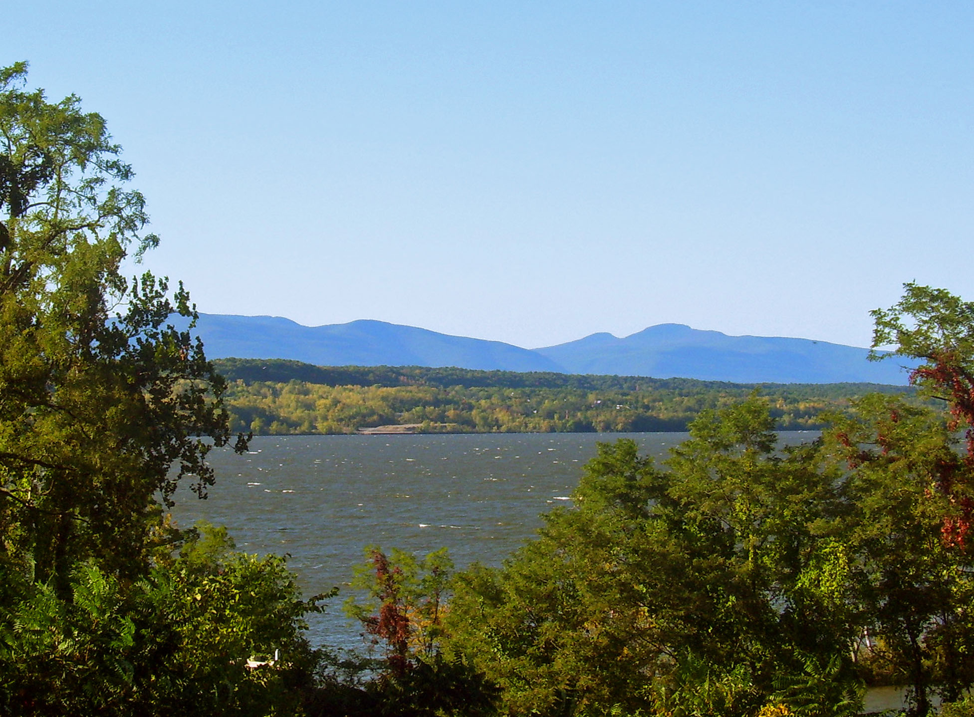
The Catskill Mountains, also known as the Catskills, are a physiographic province of the larger Appalachian Mountains, located in southeastern New York. As a cultural and geographic region, the Catskills are generally defined as those areas close to or within the borders of the Catskill Park, a forest preserve protected from many forms of development under New York state law. Geologically, the Catskills are a mature dissected plateau, a flat region subsequently uplifted and eroded into sharp relief by watercourses. The Catskills form the northeastern end of the Allegheny Plateau (also known as the Appalachian Plateau). The Catskills were named by early Dutch settlers. They are well known in American society as the setting for films and works of art, including many 19th-century Hudson River School paintings, as well as for being a favored destination for vacationers from New York City in the mid-20th century. The region's many large resorts gave many young stand-up comedian ... [...More Info...] [...Related Items...] OR: [Wikipedia] [Google] [Baidu] |
Mohawk Valley
The Mohawk Valley region of the U.S. state of New York is the area surrounding the Mohawk River, sandwiched between the Adirondack Mountains and Catskill Mountains, northwest of the Capital District. As of the 2010 United States Census, the region's counties have a combined population of 622,133 people. In addition to the Mohawk River valley, the region contains portions of other major watersheds such as the Susquehanna River. The region is a suburban and rural area surrounding the industrialized cities of Schenectady, Utica and Rome, along with other smaller commercial centers. The area is an important agricultural center and encompasses the heavily forested wilderness areas just to the north that are part of New York's Adirondack Park. The Mohawk Valley is a natural passageway connecting the Atlantic Ocean, by way of the Hudson Valley, with the interior of North America. Native American Nations of the Iroquois Confederacy lived in the region. In the 17th century, Dutch ... [...More Info...] [...Related Items...] OR: [Wikipedia] [Google] [Baidu] |
Appalachian Plateau
The Appalachian Plateau is a series of rugged dissected plateaus located on the western side of the Appalachian Mountains. The Appalachian Mountains are a mountain range that run down the Eastern United States. The Appalachian Plateau is the northwestern part of the Appalachian Mountains, stretching from New York to Alabama. The plateau is a second level United States physiographic region, covering parts of the states of New York, Pennsylvania, Ohio, Maryland, West Virginia, Virginia, Kentucky, Tennessee, Alabama, and Georgia. Geography and physical features The formation of the plateau began during the Paleozoic Era. Regional uplift during this time caused the area to rise altogether without changing the topography of the land. The eastern side of the plateau appears as a mountain range. This false appearance is due to a very steep slope on the eastern side known as the Allegheny Front. The eastern edge is the highest part of the Appalachian Plateau. In Pennsylvania, the ele ... [...More Info...] [...Related Items...] OR: [Wikipedia] [Google] [Baidu] |


