|
Grand Teton National Park
Grand Teton National Park is an American national park in northwestern Wyoming. At approximately , the park includes the major peaks of the Teton Range as well as most of the northern sections of the valley known as Jackson Hole. Grand Teton National Park is only south of Yellowstone National Park, to which it is connected by the National Park Service–managed John D. Rockefeller Jr. Memorial Parkway. Along with surrounding national forests, these three protected areas constitute the almost Greater Yellowstone Ecosystem, one of the world's largest intact mid-latitude temperate ecosystems. The human history of the Grand Teton region dates back at least 11,000 years when the first nomadic hunter-gatherer Paleo-Indians began migrating into the region during warmer months to pursue food and supplies. In the early 19th century, the first white explorers encountered the eastern Shoshone natives. Between 1810 and 1840, the region attracted fur trading companies that vied fo ... [...More Info...] [...Related Items...] OR: [Wikipedia] [Google] [Baidu] |
Teton Range
The Teton Range is a mountain range of the Rocky Mountains in North America. It extends for approximately in a north–south direction through the U.S. state of Wyoming, east of the Idaho state line. It is south of Yellowstone National Park and most of the east side of the range is within Grand Teton National Park. One theory says the early French voyageurs named the range ' ("the three nipples") after the breast-like shapes of its peaks. Another theory says the range is named for the Teton Sioux (from Thítȟuŋwaŋ), also known as the Lakota people.Ullrich, Jan. (2008). ''New Lakota Dictionary''. Lakota Language Consortium. It is likely that the local Shoshone people once called the whole range ', meaning "many pinnacles". The principal summits of the central massif, sometimes referred to as the Cathedral Group, are Grand Teton (), Mount Owen (), Teewinot (), Middle Teton () and South Teton (). Other peaks in the range include Mount Moran (), Mount Wister (), Buck Mounta ... [...More Info...] [...Related Items...] OR: [Wikipedia] [Google] [Baidu] |
Jackson Hole National Monument
On March 15, 1943, Franklin D. Roosevelt signed Presidential Proclamation 2578 establishing a large swath of land east of the Teton National Park as a national monument.Booklet of the Congressional hearing to abolish the Jackson Hole national Monument, 1A, Booklets, Burt Family Collection, 7570, American Heritage Center, University of Wyoming. The area of land covered 221,610 acres. The majority of the land was National Forest, but 32,117 acres of the monument were donated by John D. Rockefeller, Jr., and 17,000 acres were privately owned ranches. This proclamation incited a controversy in Teton County that caused immediate pushback from western congressmen who saw the act as a violation of state sovereignty.Box 1A, Burt Family Papers, 1911-1970, 07570, American Heritage Center, University of Wyoming Background Within Teton County, private interests regularly fought for their right to use natural resources available to them which worried conservationist parties and started a ch ... [...More Info...] [...Related Items...] OR: [Wikipedia] [Google] [Baidu] |
Semi-arid Climate
A semi-arid climate, semi-desert climate, or steppe climate is a dry climate sub-type. It is located on regions that receive precipitation below potential evapotranspiration, but not as low as a desert climate. There are different kinds of semi-arid climates, depending on variables such as temperature, and they give rise to different biomes. Defining attributes of semi-arid climates A more precise definition is given by the Köppen climate classification, which treats steppe climates (''BSk'' and ''BSh'') as intermediates between desert climates (BW) and humid climates (A, C, D) in ecological characteristics and agricultural potential. Semi-arid climates tend to support short, thorny or scrubby vegetation and are usually dominated by either grasses or shrubs as it usually can't support forests. To determine if a location has a semi-arid climate, the precipitation threshold must first be determined. The method used to find the precipitation threshold (in millimeters): *multiply by ... [...More Info...] [...Related Items...] OR: [Wikipedia] [Google] [Baidu] |
Shoshoni Tipis
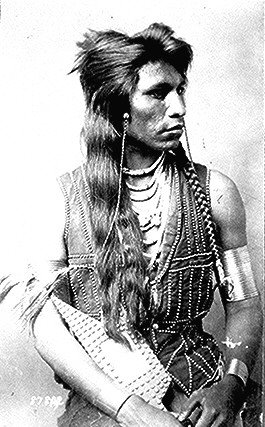
The Shoshone or Shoshoni ( or ) are a Native American tribe with four large cultural/linguistic divisions: * Eastern Shoshone: Wyoming * Northern Shoshone: southern Idaho * Western Shoshone: Nevada, northern Utah * Goshute: western Utah, eastern Nevada They traditionally speak the Shoshoni language, part of the Numic languages branch of the large Uto-Aztecan language family. The Shoshone were sometimes called the Snake Indians by neighboring tribes and early American explorers. Their peoples have become members of federally recognized tribes throughout their traditional areas of settlement, often co-located with the Northern Paiute people of the Great Basin. Etymology The name "Shoshone" comes from ''Sosoni'', a Shoshone word for high-growing grasses. Some neighboring tribes call the Shoshone "Grass House People," based on their traditional homes made from ''sosoni''. Shoshones call themselves ''Newe'', meaning "People".Loether, Christopher"Shoshones."''Encyclopedia of the Gre ... [...More Info...] [...Related Items...] OR: [Wikipedia] [Google] [Baidu] |
Concession (contract)
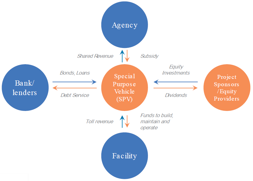
A concession or concession agreement is a grant of rights, land or property by a government, local authority, corporation, individual or other legal entity. Public services such as water supply may be operated as a concession. In the case of a public service concession, a private company enters into an agreement with the government to have the exclusive right to operate, maintain and carry out investment in a public utility (such as a water privatisation) for a given number of years. Other forms of contracts between public and private entities, namely lease contract and management contract (in the water sector often called by the French term ''affermage''), are closely related but differ from a concession in the rights of the operator and its remuneration. A lease gives a company the right to operate and maintain a public utility, but investment remains the responsibility of the public. Under a management contract the operator will collect the revenue only on behalf of the govern ... [...More Info...] [...Related Items...] OR: [Wikipedia] [Google] [Baidu] |
Snake River Fine-spotted Cutthroat Trout
The Snake River fine-spotted cutthroat trout is a form of the cutthroat trout (''Oncorhynchus clarkii'') that is considered either as a separate subspecies ''O. c. behnkei'', or as a variety of the Yellowstone cutthroat trout (''O. c. bouvieri''). The fish takes its common name from its original habitat, the Snake River of southern Idaho and western Wyoming, and from its unusual pattern of hundreds of small spots that cover most of its body, differing from the larger-spotted Yellowstone cutthroat pattern. Genetically, it cannot be distinguished from the Yellowstone cutthroat trout, and before the construction of dams, no physical barriers were between the ranges of the two subspecies in the Snake River drainage. The subspecies was scientifically named in 1995 in a popular book by columnist M. R. Montgomery, to honor the fisheries research of Dr. Robert J. Behnke, who had presented its (unnamed) description in 1992.Behnke R (2002Trout and Salmon of North Americap. 175. The Free P ... [...More Info...] [...Related Items...] OR: [Wikipedia] [Google] [Baidu] |
Backcountry
In the United States, a backcountry or backwater is a geographical area that is remote, undeveloped, isolated, or difficult to access. Terminology Backcountry and wilderness within United States national parks The National Park Service (NPS) generally uses the term "backcountry" to refer to "primitive, undeveloped portions of parks". Developments within backcountry areas are generally limited to trails, unpaved roads, and administrative facilities associated with dispersed recreational use. Dispersed recreational use is the most prevalent human use in backcountry areas, although research activities may also occur. The NPS defines wilderness within US national parks as any "backcountry areas which have been specifically designated as part of the National Wilderness Preservation System or any other area that has been determined to possess the characteristics of wilderness as defined by Section 2(c) of the Wilderness Act". Section 2(c) states in part that wilderness: Wilderne ... [...More Info...] [...Related Items...] OR: [Wikipedia] [Google] [Baidu] |
Whitebark Pine
''Pinus albicaulis'', known by the common names whitebark pine, white bark pine, white pine, pitch pine, scrub pine, and creeping pine, is a conifer tree native to the mountains of the western United States and Canada, specifically subalpine areas of the Sierra Nevada, Cascade Range, Pacific Coast Ranges, and Rocky Mountains. It shares the common name "creeping pine" with several other plants. The whitebark pine is typically the highest-elevation pine tree found in these mountain ranges and often marks the tree line. Thus, it is often found as ''krummholz'', trees growing close to the ground that have been dwarfed by exposure. In more favorable conditions, the trees may grow to in height. Identification Whitebark pine is a member of the white pine group, the ''Pinus'' subgenus ''Strobus'', and the section ''Strobus''; like all members of this group, the leaves (needles) are in fascicles (bundles) of five with a deciduous sheath. This distinguishes whitebark pine and its r ... [...More Info...] [...Related Items...] OR: [Wikipedia] [Google] [Baidu] |
Vascular Plants
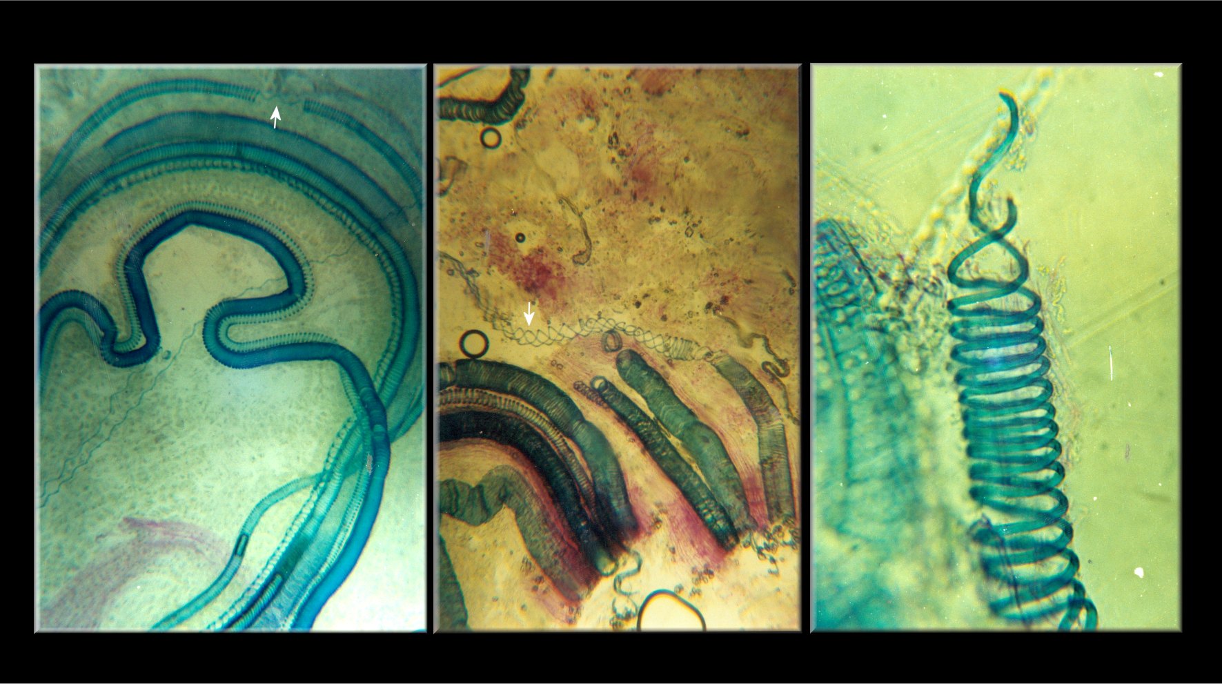
Vascular plants (), also called tracheophytes () or collectively Tracheophyta (), form a large group of land plants ( accepted known species) that have lignified tissues (the xylem) for conducting water and minerals throughout the plant. They also have a specialized non-lignified tissue (the phloem) to conduct products of photosynthesis. Vascular plants include the clubmosses, horsetails, ferns, gymnosperms (including conifers), and angiosperms (flowering plants). Scientific names for the group include Tracheophyta, Tracheobionta and Equisetopsida ''sensu lato''. Some early land plants (the rhyniophytes) had less developed vascular tissue; the term eutracheophyte has been used for all other vascular plants, including all living ones. Historically, vascular plants were known as "higher plants", as it was believed that they were further evolved than other plants due to being more complex organisms. However, this is an antiquated remnant of the obsolete scala naturae, and the term ... [...More Info...] [...Related Items...] OR: [Wikipedia] [Google] [Baidu] |
Snake River
The Snake River is a major river of the greater Pacific Northwest region in the United States. At long, it is the largest tributary of the Columbia River, in turn, the largest North American river that empties into the Pacific Ocean. The Snake River rises in western Wyoming, then flows through the Snake River Plain of southern Idaho, the rugged Hells Canyon on the Oregon–Idaho border and the rolling Palouse Hills of Washington (state), Washington, emptying into the Columbia River at the Tri-Cities, Washington, Tri-Cities in the Columbia Basin of Eastern Washington. The Snake River drainage basin encompasses parts of six U.S. states (Idaho, Washington, Oregon, Utah, Nevada, and Wyoming) and is known for its varied geologic history. The Snake River Plain was created by a volcanic hotspot (geology), hotspot which now lies underneath the Snake River headwaters in Yellowstone National Park. Gigantic glacial-retreat flooding episodes during the previous Last glacial period, Ice Ag ... [...More Info...] [...Related Items...] OR: [Wikipedia] [Google] [Baidu] |
Main Stem
In hydrology, a mainstem (or trunk) is "the primary downstream segment of a river, as contrasted to its tributaries". Water enters the mainstem from the river's drainage basin, the land area through which the mainstem and its tributaries flow.. A drainage basin may also be referred to as a ''watershed'' or ''catchment''. Hydrological classification systems assign numbers to tributaries and mainstems within a drainage basin. In the Strahler number, a modification of a system devised by Robert E. Horton in 1945, channels with no tributaries are called "first-order" streams. When two first-order streams meet, they are said to form a second-order stream; when two second-order streams meet, they form a third-order stream, and so on. In the Horton system, the entire mainstem of a drainage basin was assigned the highest number in that basin. However, in the Strahler system, adopted in 1957, only that part of the mainstem below the tributary of the next highest rank gets the highest num ... [...More Info...] [...Related Items...] OR: [Wikipedia] [Google] [Baidu] |
Jackson Lake (Wyoming)
Jackson Lake is in Grand Teton National Park in northwestern Wyoming. This natural lake was enlarged by the construction of the Jackson Lake Dam, which was originally built in 1911, enlarged in 1916 and rebuilt by 1989. As part of the Minidoka Project the top of the lake is used by farmers in Idaho for irrigation purposes under water rights legislation that was enacted prior to the establishment of Grand Teton National Park. The lake is the remnant of large glacial gouging from the neighboring Teton Range to the west and the Yellowstone Plateau to the north. The lake is primarily fed by the Snake River, which flows in from the north, and empties at Jackson Lake Dam. Jackson Lake is one of the largest high altitude lakes in the United States, at an elevation of above sea level. The lake is up to long, wide and deep. The water of the lake averages below , even during the summer. Numerous species of fish inhabit the lake including nonnative brown and lake trout and the native S ... [...More Info...] [...Related Items...] OR: [Wikipedia] [Google] [Baidu] |


