|
East Siberian Lowland
The East Siberian Lowland ( rus, Восточно-Сибирская низменность), also known as Yana-Kolyma Lowland,Oleg Leonidovič Kryžanovskij, ''A Checklist of the Ground-beetles of Russia and Adjacent Lands.'' p. 16 is a vast plain in Northeastern Siberia, Russia.Yana-Indigirka and Kolyma lowlands (physical map, scale 1: 2 500 000) // National Atlas of Russia . - M .: Roskartografiya, 2004. - T. 1. - S. 260—261. - 496 p. - The territory of the lowland is one of the . Administratively it is part of the |
Ust-Yansky District
Ust-Yansky District (russian: Усть-Я́нский улу́с; sah, Усуйаана улууһа, ''Usuyaana uluuha'', ) is an administrativeConstitution of the Sakha Republic and municipalLaw #172-Z #351-III district (raion, or ''ulus''), one of the thirty-four in the Sakha Republic, Russia. It is located in the north of the republic in the Yana River delta on the coast of the Laptev Sea and borders with Allaikhovsky and Abyysky Districts in the east, Momsky District in the south, Verkhoyansky District in the southwest, and with Bulunsky District in the west. The area of the district is .Registry of the Administrative-Territorial Divisions of the Sakha Republic Its administrative center is the urban locality (a settlement) of Deputatsky. Population: 10,009 ( 2002 Census); The population of Deputatsky accounts for 37.0% of the district's total population. Geography The main rivers in the district include the Yana, the Omoloy with the Ulakhan-Kyuegyulyur, the Sellyakh ... [...More Info...] [...Related Items...] OR: [Wikipedia] [Google] [Baidu] |
Yana-Indigirka Lowland
The Yana-Indigirka Lowland (russian: Яно-Индигирская низменность; sah, Дьааҥы - Индигир намтала) is a large, low alluvial plain located in northern Siberia, Far Eastern Federal District, Russia. Administratively most of the territory of the lowland is part of the Sakha Republic (Yakutia). There are inhabited centers of population in the lowlands such as Chokurdakh, Olenegorsk and Nizhneyansk, but these are very few and scattered. Geography The lowland is named after the Yana River in the west and the Indigirka River in the east and is crossed by both rivers in their middle and lower courses. The area is mostly flat and very marshy, its northern limits extending for over from the Buor Khaya Gulf of the Laptev Sea in the west to the delta of river Indigirka in the East Siberian Sea in the east. It is limited by the Kyundyulyun, the northern end of the Selennyakh Range and the Polousny Range in the south. [...More Info...] [...Related Items...] OR: [Wikipedia] [Google] [Baidu] |
Laptev Sea
The Laptev Sea ( rus, мо́ре Ла́птевых, r=more Laptevykh; sah, Лаптевтар байҕаллара, translit=Laptevtar baỹğallara) is a marginal sea of the Arctic Ocean. It is located between the northern coast of Siberia, the Taimyr Peninsula, Severnaya Zemlya and the New Siberian Islands. Its northern boundary passes from the Arctic Cape to a point with co-ordinates of 79°N and 139°E, and ends at the Anisiy Cape. The Kara Sea lies to the west, the East Siberian Sea to the east. The sea is named after the Russian explorers Dmitry Laptev and Khariton Laptev; formerly, it had been known under various names, the last being Nordenskiöld Sea (russian: link=no, мо́ре Норденшёльда), after explorer Adolf Erik Nordenskiöld. The sea has a severe climate with temperatures below 0 °C (32 °F) over more than nine months per year, low water salinity, scarcity of flora, fauna and human population, and low depths (mostly less than 50 meters) ... [...More Info...] [...Related Items...] OR: [Wikipedia] [Google] [Baidu] |
Arctic Ocean
The Arctic Ocean is the smallest and shallowest of the world's five major oceans. It spans an area of approximately and is known as the coldest of all the oceans. The International Hydrographic Organization (IHO) recognizes it as an ocean, although some oceanographers call it the Arctic Mediterranean Sea. It has been described approximately as an estuary of the Atlantic Ocean. It is also seen as the northernmost part of the all-encompassing World Ocean. The Arctic Ocean includes the North Pole region in the middle of the Northern Hemisphere and extends south to about 60°N. The Arctic Ocean is surrounded by Eurasia and North America, and the borders follow topographic features: the Bering Strait on the Pacific side and the Greenland Scotland Ridge on the Atlantic side. It is mostly covered by sea ice throughout the year and almost completely in winter. The Arctic Ocean's surface temperature and salinity vary seasonally as the ice cover melts and freezes; its salinity is t ... [...More Info...] [...Related Items...] OR: [Wikipedia] [Google] [Baidu] |
Kigilyakh
Kigilyakh or kisiliyakh ( rus, кигиляхи; sah, киһилээх, meaning "stone person") are tall, pillar-like natural rock formations looking like tall monoliths standing more or less isolated. Usually they are composed of granite or sandstone shaped as a result of cryogenic weathering. Most kigilyakhs formed during the Cretaceous period and are about 120 million years old. Cultural significance and etymology These anthropomorphic rock pillars are an important feature in Yakut culture. Often they are slightly scattered, protruding from the surface of smooth mountains and giving the impression of a standing crowd of people. According to Yakut legends kigilyakhs originated in very ancient people. The Yakut word ''"kisiliy"'' means "a place where there are people". ''Kisilyakh'' means "mountain having a man" or "mountain married". The term "kigilyakh" is a distorted form of the original Yakut ''"kisilyakh"''. Locations Such stones are found in different places of Sakha ( ... [...More Info...] [...Related Items...] OR: [Wikipedia] [Google] [Baidu] |
Alazeya River
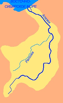
The Alazeya ( rus, Алазея, r=; sah, Алаһыай, translit=Alahıay) is a river in the northeastern part of Yakutia, Russia which flows into the Arctic between the basins of the larger Indigirka to the west and the Kolyma to the east. Mount Kisilyakh-Tas is a notable kigilyakh site on the right bank of the Alazeya River at . Geography The river is long. The area of its basin is . The Alazeya is formed at the confluence of the Nelkan and Kadylchan rivers in the slopes of the Alazeya Plateau. It crosses roughly northwards through the tundra meandering among the flat, marshy areas of the Kolyma Lowland, part of the greater East Siberian Lowland. Finally the Alazeya drains into the Kolyma Bay of the East Siberian Sea, close to Logashkino. The river freezes in late September through early October and stays icebound until late May through early June. There are more than 24,000 lakes in its basin. Google Earth [...More Info...] [...Related Items...] OR: [Wikipedia] [Google] [Baidu] |
Kisilyakh-Tas
Kisilyakh-Tas ( rus, гора Кисилях-Тас) is a mountain in Yakutia, Far Eastern Federal District, Russia. Administratively it belongs to the Lower Kolyma District. This mountain is one of the renowned places of Yakutia where kigilyakhs are found. The largest of them are between and in height. Kigilyakhs are rock formations that are held in high esteem by Yakuts. ''Kisilyakh'' means "Mountain having a man" or "Mountain married" in the Yakut language. Geography Mount Kisilyakh-Tas is a small, isolated mountain massif of the Kolyma Lowland, located east of the Suor Uyata range. It rises above the tundra on the right bank of the Alazeya, roughly south of the river's mouth in the shores of the East Siberian Sea. Kisilyakh-Tas is located in a flat area, where there are only two other mountains nearby, a higher one to the SW and a smaller one to the west, both on the other side of the river. The three mountains are roughly at the same distance from each other. Andr ... [...More Info...] [...Related Items...] OR: [Wikipedia] [Google] [Baidu] |
Suor Uyata
The Suor Uyata ( rus, Суор-Уята; sah, Суор Уйата) is a mountain range in the Sakha Republic, Far Eastern Federal District, Russia. The village of Andryushkino, a small inhabited locality of the Lower Kolyma District, is located to the SSE.Google Earth Kigilyakhs, rock formations that are an important element of the culture of the Yakuts, are found in the Suor Uyata range. to the ESE of the eastern end of the range, on the right bank of the Alazeya River, rises the high Kisilyakh-Tas, another important Kigilyakh site. History The Suor Uyata was first mapped in the summer of 1870 by geographer and ethnologist Baron Gerhard von Maydell (1835–1894) during his pioneering research of East Siberia. Geography The Suor Uyata rises in the northwestern area of the Kolyma Lowland, only to the east of the eastern end of the Ulakhan-Sis Range. It is a smaller range than the latter, of which it can be considered an eastern prolongation. The main ridge stretches in a ro ... [...More Info...] [...Related Items...] OR: [Wikipedia] [Google] [Baidu] |
Kondakov Plateau
The Kondakov Plateau ( rus, Кондаковское плоскогорье; sah, Кондаков хаптал хайалаах сирэ) is a mountain plateau in the Sakha Republic, Far Eastern Federal District, Russia. The town of Chokurdakh is located on the other bank of the Indigirka, facing the plateau. The nearest airport is Chokurdakh Airport. The Shandrin mammoth was discovered in 1974 at the feet of a steep slope in the eastern side of the Kondakov Plateau by geologist B. S. Rusanov of the Yakutsk Institute of Geology. Geography The Kondakov Plateau is located in eastern Yakutia, rising above the right banks of the lower course of the Indigirka and gradually decreasing in elevation to the east. Slopes are generally smooth and gentle and the average height of the plateau surface is between and . There are slightly higher ridges cutting across the plateau area, the Bonga-Taga ridge in the north and the Mokholukan in the south. The highest point is high Punga Khaya ... [...More Info...] [...Related Items...] OR: [Wikipedia] [Google] [Baidu] |
Ulakhan-Sis
The Ulakhan-Sis Range ( rus, Улахан-Сис; sah, Улахан Сис) is a mountain range in the Sakha Republic, Far Eastern Federal District, Russia.Улахан-Сис (Ulakhan-Sis) / ; in 35 vols. / Ch. ed. Yu. S. Osipov. 2004—2017. This range is one of the areas of Yakutia where s are found. |
Polousny Range
The Polousny Range ( rus, Полоусный кряж; sah, Полоуснай томтороот) is a mountain range in the Sakha Republic, Far Eastern Federal District, Russia.Полоусный кряж (Polousny Range) / Great Soviet Encyclopedia; in 35 vols. / Ch. ed. Yu. S. Osipov. 2004—2017. This range is one of the areas of Yakutia where kigilyakhs are found. History The area of the Polousny Range was first mapped by geographer and ethnologist Baron Gerhard von Maydell (1835–1894) during his pioneering research of East Siberia. The Chondon mammoth was discovered in 2013, at the feet of the Polousny Range in the Chondon basin, 66 km south-west of the village of Tumat. Geography The Polousny Range is part of the Momsko-Chersk Mountain Region (russian: Момско-Черская область). It rises in the southern area of the Yana-Indigirka Lowland, north of the Aby Lowland in the Sakha region. It is made up of mountains of middle height and smooth slopes. I ... [...More Info...] [...Related Items...] OR: [Wikipedia] [Google] [Baidu] |
Kyundyulyun
The Kyundyulyun ( rus, Кюндюлюн or Горы Кюндюлюн; sah, Күндүлүн) is a mountain range in the Sakha Republic, Far Eastern Federal District, Russia. The nearest airport is Ust-Kuyga Airport, located in Ust-Yansky District.Google Earth Geography The Kyundyulyun Range is located in northern Yakutia, about north of the Arctic Circle. It is a smooth-looking range, rising above the right bank of the lower course of the Yana River. The Kyundyulyun forms a northeastern prolongation of the Kular Range, which extends from the southwest on the other side of the Yana, overlapping with the northern foothills of the Chersky Range that extend from the southeast. The highest point is an unnamed high summit located in the southwestern part. To the north and northeast the Kyundyulyun is limited by the Yana-Indigirka Lowland, part of the East Siberian Lowland. To the east and southeast the northern foothills of the Chersky Range extend southwards and to the west and ... [...More Info...] [...Related Items...] OR: [Wikipedia] [Google] [Baidu] |


.jpg)


