|
Cold Fronts
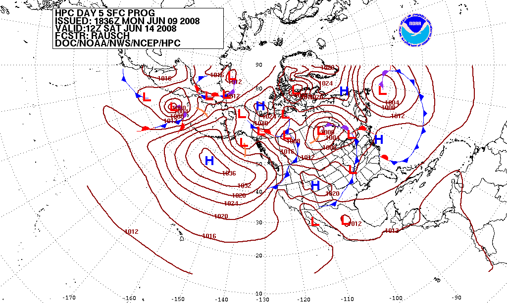
A cold front is the leading edge of a cooler mass of air at ground level that replaces a warmer mass of air and lies within a pronounced surface trough of low pressure. It often forms behind an extratropical cyclone (to the west in the Northern Hemisphere, to the east in the Southern), at the leading edge of its cold air advection pattern—known as the cyclone's dry "conveyor belt" flow. Temperature differences across the boundary can exceed from one side to the other. When enough moisture is present, rain can occur along the boundary. If there is significant instability along the boundary, a narrow line of thunderstorms can form along the frontal zone. If instability is weak, a broad shield of rain can move in behind the front, and evaporative cooling of the rain can increase the temperature difference across the front. Cold fronts are stronger in the fall and spring transition seasons and are weakest during the summer. Development of cold fronts A cold front occurs when a m ... [...More Info...] [...Related Items...] OR: [Wikipedia] [Google] [Baidu] |
Trough (meteorology)
A trough is an elongated region of relatively low atmospheric pressure without a closed isobaric contour that would define it as a low pressure area. Since low pressure implies a low height on a pressure surface, troughs and ridges refer to features in an identical sense as those on a topographic map. Troughs may be at the surface, or aloft. Near-surface troughs sometimes mark a weather front associated with clouds, showers, and a wind direction shift. Upper-level troughs in the jet stream (as shown in diagram) reflect cyclonic filaments of vorticity. Their motion induces upper-level wind divergence, lifting and cooling the air ahead (downstream) of the trough and helping to produce cloudy and rain conditions there. Unlike fronts, there is not a universal symbol for a trough on a surface weather analysis chart. The weather charts in some countries or regions mark troughs by a line. In the United States, a trough may be marked as a dashed line or bold line. In the UK, Hong Kong ... [...More Info...] [...Related Items...] OR: [Wikipedia] [Google] [Baidu] |
Temperature
Temperature is a physical quantity that expresses quantitatively the perceptions of hotness and coldness. Temperature is measured with a thermometer. Thermometers are calibrated in various temperature scales that historically have relied on various reference points and thermometric substances for definition. The most common scales are the Celsius scale with the unit symbol °C (formerly called ''centigrade''), the Fahrenheit scale (°F), and the Kelvin scale (K), the latter being used predominantly for scientific purposes. The kelvin is one of the seven base units in the International System of Units (SI). Absolute zero, i.e., zero kelvin or −273.15 °C, is the lowest point in the thermodynamic temperature scale. Experimentally, it can be approached very closely but not actually reached, as recognized in the third law of thermodynamics. It would be impossible to extract energy as heat from a body at that temperature. Temperature is important in all fields of natur ... [...More Info...] [...Related Items...] OR: [Wikipedia] [Google] [Baidu] |
Cumulus
Cumulus clouds are clouds which have flat bases and are often described as "puffy", "cotton-like" or "fluffy" in appearance. Their name derives from the Latin ''cumulo-'', meaning ''heap'' or ''pile''. Cumulus clouds are low-level clouds, generally less than in altitude unless they are the more vertical cumulus congestus form. Cumulus clouds may appear by themselves, in lines, or in clusters. Cumulus clouds are often precursors of other types of clouds, such as cumulonimbus, when influenced by weather factors such as instability, moisture, and temperature gradient. Normally, cumulus clouds produce little or no precipitation, but they can grow into the precipitation-bearing congests or cumulonimbus clouds. Cumulus clouds can be formed from water vapour, supercooled water droplets, or ice crystals, depending upon the ambient temperature. They come in many distinct subforms and generally cool the earth by reflecting the incoming solar radiation. Cumulus clouds are part of the larg ... [...More Info...] [...Related Items...] OR: [Wikipedia] [Google] [Baidu] |
Stratus Fractus
Fractus clouds (''scuds'') also known as Fractostratus or Fracto-Cumulus are small, ragged cloud fragments that are usually found under an ambient cloud base. They form or have broken off from a larger cloud, and are generally sheared by strong winds, giving them a jagged, shredded appearance. Fractus have irregular patterns, appearing much like torn pieces of cotton candy. They change constantly, often forming and dissipating rapidly. They do not have clearly defined bases. Sometimes they are persistent and form very near the surface. Common kinds include ''scud'' and ''cloud tags''. Forms Fractus are accessory clouds, named for the type of cloud from which they were sheared. The two principal forms are cumulus fractus (formerly, fractocumulus) and stratus fractus (formerly, fractostratus). Fractus clouds may develop into cumulus if the ground heats enough to start convection. Stratus fractus is distinguishable from cumulus fractus by its smaller vertical extent, darker col ... [...More Info...] [...Related Items...] OR: [Wikipedia] [Google] [Baidu] |
Cirrus Cloud
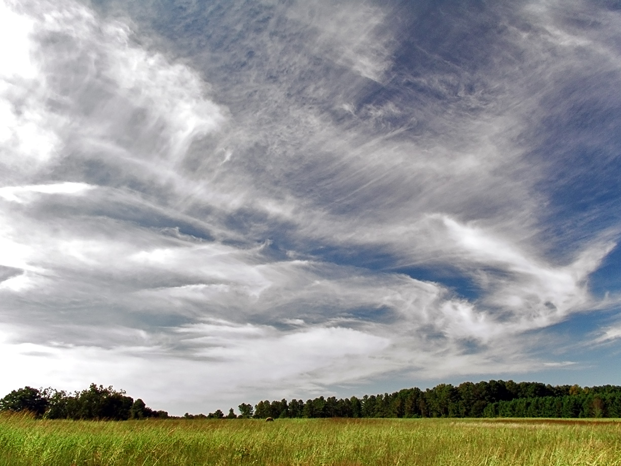
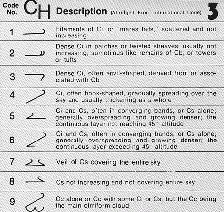
Cirrus ( cloud classification symbol: Ci) is a genus of high cloud made of ice crystals. Cirrus clouds typically appear delicate and wispy with white strands. Cirrus are usually formed when warm, dry air rises, causing water vapor deposition onto rocky or metallic dust particles at high altitudes. Globally, they form anywhere between above sea level, with the higher elevations usually in the tropics The tropics are the regions of Earth surrounding the Equator. They are defined in latitude by the Tropic of Cancer in the Northern Hemisphere at N and the Tropic of Capricorn in the Southern Hemisphere at S. The tropics are also referr ... and the lower elevations in more Polar regions of Earth, polar regions. Cirrus clouds can form from the tops of cumulonimbus cloud, thunderstorms and tropical cyclones and sometimes predict the arrival of precipitation, rain or storms. Although they are a sign that rain and maybe storms are on the way, cirrus themselves drop no more ... [...More Info...] [...Related Items...] OR: [Wikipedia] [Google] [Baidu] |
Stratocumulus
A stratocumulus cloud, occasionally called a cumulostratus, belongs to a genus-type of clouds characterized by large dark, rounded masses, usually in groups, lines, or waves, the individual elements being larger than those in altocumulus, and the whole being at a lower height, usually below . Weak convective currents create shallow cloud layers because of drier, stable air above preventing continued vertical development. Historically, in English, this type of cloud has been referred to as a twain cloud for being a combination of two types of clouds. Description Occurrence Vast areas of subtropical and polar oceans are covered with massive sheets of stratocumulus. These may organize into distinctive patterns which are currently under active study. In subtropics, they cover the edges of the horse latitude climatological highs, and reduce the amount of solar energy absorbed in the ocean. When these drift over land the summer heat or winter cold is reduced. 'Dull weather' is a common ... [...More Info...] [...Related Items...] OR: [Wikipedia] [Google] [Baidu] |
Altocumulus
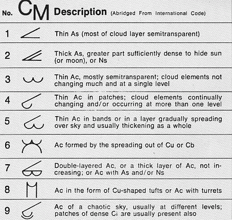
Altocumulus (From Latin ''Altus'', "high", ''cumulus'', "heaped") is a middle-altitude cloud genus that belongs mainly to the ''stratocumuliform'' physical category characterized by globular masses or rolls in layers or patches, the individual elements being larger and darker than those of cirrocumulus and smaller than those of stratocumulus. However, if the layers become tufted in appearance due to increased airmass instability, then the altocumulus clouds become more purely ''cumuliform'' in structure. Like other cumuliform and stratocumuliform clouds, altocumulus signifies convection. A sheet of partially conjoined altocumulus perlucidus is sometimes found preceding a weakening warm front, where the altostratus is starting to fragment, resulting in patches of altocumulus perlucidus between the areas of altostratus. Altocumulus is also commonly found between the warm and cold fronts in a depression, although this is often hidden by lower clouds. Towering altocumulus, known as a ... [...More Info...] [...Related Items...] OR: [Wikipedia] [Google] [Baidu] |
Cirrostratus
Cirrostratus is a high-level, very thin, generally uniform ''stratiform'' genus-type of cloud. It is made out of ice-crystals, which are pieces of frozen water. It is difficult to detect and it can make halos. These are made when the cloud takes the form of thin cirrostratus nebulosus. The cloud has a fibrous texture with no halos if it is thicker cirrostratus fibratus. On the approach of a frontal system, the cirrostratus often begins as nebulous and turns to fibratus. If the cirrostratus begins as fragmented of clouds in the sky it often means the front is weak. Cirrostratus is usually located above 5.5 km (18,000 ft). Its presence indicates a large amount of moisture in the upper troposphere. Clouds resembling cirrostratus occasionally form in polar regions of the lower stratosphere. Polar stratospheric clouds can take on this appearance when composed of tiny supercooled droplets of water or nitric acid. Cirrostratus clouds sometimes signal the approach of a warm fr ... [...More Info...] [...Related Items...] OR: [Wikipedia] [Google] [Baidu] |
Thunderstorms
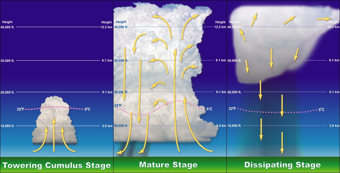
A thunderstorm, also known as an electrical storm or a lightning storm, is a storm characterized by the presence of lightning and its acoustic effect on the Earth's atmosphere, known as thunder. Relatively weak thunderstorms are sometimes called thundershowers. Thunderstorms occur in a type of cloud known as a cumulonimbus. They are usually accompanied by strong winds and often produce heavy rain and sometimes snow, sleet, or hail, but some thunderstorms produce little precipitation or no precipitation at all. Thunderstorms may line up in a series or become a rainband, known as a squall line. Strong or severe thunderstorms include some of the most dangerous weather phenomena, including large hail, strong winds, and tornadoes. Some of the most persistent severe thunderstorms, known as supercells, rotate as do cyclones. While most thunderstorms move with the mean wind flow through the layer of the troposphere that they occupy, vertical wind shear sometimes causes a dev ... [...More Info...] [...Related Items...] OR: [Wikipedia] [Google] [Baidu] |
Snowsquall
A snowsquall, or snow squall, is a sudden moderately heavy snowfall with blowing snow and strong, gusty surface winds. It is often referred to as a whiteout and is similar to a blizzard but is localized in time or in location and snow accumulations may or may not be significant. Types There are two primary types of snowsqualls: lake effect and frontal. Lake-effect snow When arctic air moves over large expanses of warmer open waters in winter, convective clouds develop which cause heavy snow showers due to the large amount of moisture available. This occurs southwest of extratropical cyclones, with the curved cyclonic wind flow bringing cold air across the relatively warm Great Lakes which then leads to narrow lake-effect snow bands that can produce significant localized snowfall. Whiteout conditions will affect narrow corridors from shores to inland areas aligned along the prevailing wind direction. This will be enhanced when the moving air mass is uplifted by higher eleva ... [...More Info...] [...Related Items...] OR: [Wikipedia] [Google] [Baidu] |
Squall Line
A squall line, or more accurately a quasi-linear convective system (QLCS), is a line of thunderstorms, often forming along or ahead of a cold front. In the early 20th century, the term was used as a synonym for cold front (which often are accompanied by abrupt and gusty wind shifts). Linear thunderstorm structures often contain heavy precipitation, hail, frequent lightning, strong straight-line winds, and occasionally tornadoes or waterspouts. Particularly strong straight-line winds can occur where the linear structure forms into the shape of a bow echo. Tornadoes can occur along waves within a line echo wave pattern (LEWP), where mesoscale low-pressure areas are present. Some bow echoes can grow to become derechos as they move swiftly across a large area. On the back edge of the rainband associated with mature squall lines, a wake low can be present, on very rare occasions associated with a heat burst. Theory Polar front theory was developed by Jacob Bjerknes, derived from a dens ... [...More Info...] [...Related Items...] OR: [Wikipedia] [Google] [Baidu] |
Atmospheric Pressure
Atmospheric pressure, also known as barometric pressure (after the barometer), is the pressure within the atmosphere of Earth. The standard atmosphere (symbol: atm) is a unit of pressure defined as , which is equivalent to 1013.25 millibars, 760mm Hg, 29.9212 inchesHg, or 14.696psi.International Civil Aviation Organization. ''Manual of the ICAO Standard Atmosphere'', Doc 7488-CD, Third Edition, 1993. . The atm unit is roughly equivalent to the mean sea-level atmospheric pressure on Earth; that is, the Earth's atmospheric pressure at sea level is approximately 1 atm. In most circumstances, atmospheric pressure is closely approximated by the hydrostatic pressure caused by the weight of air above the measurement point. As elevation increases, there is less overlying atmospheric mass, so atmospheric pressure decreases with increasing elevation. Because the atmosphere is thin relative to the Earth's radius—especially the dense atmospheric layer at low altitudes—the Earth's gravi ... [...More Info...] [...Related Items...] OR: [Wikipedia] [Google] [Baidu] |


