|
Chiengi
Chiengi or is a historic colonial boma of the British Empire in central Africa and today is a settlement in the Luapula Province of Zambia, and headquarters of Chiengi District. Chiengi is in the north-east corner of Lake Mweru, and at the foot of wooded hills dividing that lake from Lake Mweru Wantipa, and overlooking a dambo (marshy plain) stretching northwards from the lake, where the Chiengi rivulet (the origin of the name) flows down from the hills.Mr Justice J B Thomson"Memories of Abandoned Bomas No. 8: Chiengi" ''Northern Rhodesia Journal'', Vol II, No. 6, pp67−77 (1954). History Pre-colonial history Chiengi and the area just to its north were ravaged by the slave trade and related ivory trade in the 18th Century. Numerous Arab and Swahili slave traders such as Tippu Tib operated around the north end of Lake Mweru, around Lake Mweru Wantipa and over to Lake Tanganyika. Colonial history Chiengi boma was established during the race between Belgian King Leopold II's Co ... [...More Info...] [...Related Items...] OR: [Wikipedia] [Google] [Baidu] |
Chiengi Town District Location
Chiengi or is a historic colonial boma of the British Empire in central Africa and today is a settlement in the Luapula Province of Zambia, and headquarters of Chiengi District. Chiengi is in the north-east corner of Lake Mweru, and at the foot of wooded hills dividing that lake from Lake Mweru Wantipa, and overlooking a dambo (marshy plain) stretching northwards from the lake, where the Chiengi rivulet (the origin of the name) flows down from the hills.Mr Justice J B Thomson"Memories of Abandoned Bomas No. 8: Chiengi" ''Northern Rhodesia Journal'', Vol II, No. 6, pp67−77 (1954). History Pre-colonial history Chiengi and the area just to its north were ravaged by the slave trade and related ivory trade in the 18th Century. Numerous Arab and Swahili slave traders such as Tippu Tib operated around the north end of Lake Mweru, around Lake Mweru Wantipa and over to Lake Tanganyika. Colonial history Chiengi boma was established during the race between Belgian King Leopold II's Co ... [...More Info...] [...Related Items...] OR: [Wikipedia] [Google] [Baidu] |
Chiengi District
Chiengi District with headquarters at Chiengi is the smallest and most northerly district in the Luapula Province of Zambia and was carved out of Nchelenge District after Zambia's independence. As of the 2010 Zambian Census, the district had a population of 109,147 people. Most of its population live in fishing villages along the 70 km (approx.) of the north-east shore of Lake Mweru which lies within the district. The largest settlement is Puta, 5 km south of Chiengi town, named after Chief Puta. The district is bounded by the DR Congo border in the north, Kaputa District in the east and the Kalungwishi River in the south. The eastern edge of the district is a hilly wilderness, partly in the Mweru Wantipa National Park. The hills have always been known for their wildlife, early colonial officers sustained themselves through hunting. The district commissioner's residence had wooden bars on the verandah so that the officer could sit there in the evening while lions roamed t ... [...More Info...] [...Related Items...] OR: [Wikipedia] [Google] [Baidu] |
Lake Mweru
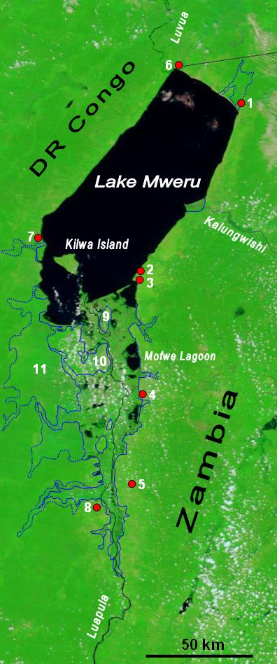
Lake Mweru (also spelled ''Mwelu'', ''Mwero'') is a freshwater lake on the longest arm of Africa's second-longest river, the Congo. Located on the border between Zambia and Democratic Republic of the Congo, it makes up of the total length of the Congo, lying between its Luapula River (upstream) and Luvua River (downstream) segments.Google Earth accessed 29 March 2007. When in flood Lake Bangweulu and its swamps may temporarily have a larger area, but not a larger volume. Mweru means 'lake' in a number of Bantu languages, so it is often referred to as just 'Mweru'.The ''Northern Rhodesia Journal'' online at NZRAM.org: J B W Anderson: "Kilwa Island and the Luapula." Vol II, No. 3 pp87–88 (1954) Physical geography Mweru is mainly fed by the Luapula River, which comes in through swamps from the south, and the Kalungwishi River from the east. At its north end the lake is drained by the Luvua River, which flows in a northwesterly direction to join the Lualaba River and thence to th ... [...More Info...] [...Related Items...] OR: [Wikipedia] [Google] [Baidu] |
Bwile People
The Bwile people are an ethnic group that live in the Democratic Republic of the Congo (DRC) and Zambia around the northern part of Lake Mweru. The Bwile language was spoken by 12,400 in Luapula Province of Zambia according to the 1969 census, and by 12,400 in the DRC as of 2002, in the Haut-Katanga Province, Pweto Territory at the north end of Lake Mweru. The Bwile people in Zambia live in the Chiengi District on the north-east shore of Lake Mweru, where they migrated from the Luba-Lunda region of the DRC. They also live in part of Nchelenge District Nchelenge District is a district of Zambia, located in the Luapula Province. The capital lies at Nchelenge. As of the 2000 Zambian Census, the district had a population of 111,119 people. Nchelenge is one of the twelve districts of Luapula Prov .... They occupy the northern end of the lake Mweru fishery from Kalobwa up to Lupiya. As of 2010 the Bwile people of Zambia were led by Senior Chief Puta. Chief Nkweto of the DRC was ... [...More Info...] [...Related Items...] OR: [Wikipedia] [Google] [Baidu] |
Luapula Province
Luapula Province is one of Zambia's ten provinces located in the northern part of the country. Luapula Province is named after the Luapula River and its capital is Mansa. As per the 2010 Zambian census, the Province had a population of 991,927, which accounted for 7.57 per cent of the total Zambian population. The province has an international border along Democratic Republic of the Congo (DR Congo) and domestically extends along the northern and eastern banks of the Luapula river from Lake Bangweulu to Lake Mweru. The province is inhabited by Bemba, who are also the major tribe in the country. Bemba is also the most spoken language in the province. The major economic activity is agriculture and fishing, with sweet potato being the major crop. Mutomboko ceremony is the most important festival celebrated. Lumangwe Falls, Mumbuluma Falls, Mumbotuta Waterfalls, Kundabwika Waterfalls and Chilongo Waterfalls are the major water falls. The chief artery of the province is the S ... [...More Info...] [...Related Items...] OR: [Wikipedia] [Google] [Baidu] |
Districts Of Zambia
The ten provinces of Zambia are divided into a total of 116 districts as of 2018. Article 109 in part VIII of the constitution of Zambia deals with local government. It states only that there should be some form of local government, and that this local government should be based on democratically elected councils on the basis of universal adult suffrage. Provincial Districts in Zambia Until 2011, Zambia was subdivided into 72 districts. However, since 2011, a number of new districts have been created, bringing the total to 116 as of 2018. ;Total Districts by Province # Central Province (11 districts) # Copperbelt Province (10 districts) # Eastern Province (15 districts) # Luapula Province (12 districts) # Lusaka Province (6 districts) # Muchinga Province (8 districts) # Northern Province (12 districts) # North-Western Province (11 districts) # Southern Province (15 districts) # Western Province (16 districts) Central Province Central Province is composed of 11 distric ... [...More Info...] [...Related Items...] OR: [Wikipedia] [Google] [Baidu] |
Leopold II Of Belgium
* german: link=no, Leopold Ludwig Philipp Maria Viktor , house = Saxe-Coburg and Gotha , father = Leopold I of Belgium , mother = Louise of Orléans , birth_date = , birth_place = Brussels, Belgium , death_date = , death_place = Laeken, Brussels, Belgium , burial_place = Church of Our Lady of Laeken , religion = Roman Catholicism Leopold II (french: link=no, Léopold Louis Philippe Marie Victor, nl, Leopold Lodewijk Filips Maria Victor; 9 April 1835 – 17 December 1909) was the second King of the Belgians from 1865 to 1909 and the self-made autocratic ruler of the Congo Free State from 1885 to 1908. Born in Brussels as the second but eldest-surviving son of Leopold I and Louise of Orléans, Leopold succeeded his father to the Belgian throne in 1865 and reigned for exactly 44 years until his death, the longest reign of a Belgian monarch to date. He died without surviving legitimate sons. The current Belgian king descends from his ne ... [...More Info...] [...Related Items...] OR: [Wikipedia] [Google] [Baidu] |
Congo Free State
''(Work and Progress) , national_anthem = Vers l'avenir , capital = Vivi Boma , currency = Congo Free State franc , religion = Catholicism (''de facto'') , leader1 = Leopold II of Belgium , year_leader1 = 1885–1908 , title_leader = Sovereign , representative1 = F. W. de Winton , year_representative1 = 1885–1886 , representative2 = Théophile Wahis , year_representative2 = 1900–1908 , title_representative = Governor-General , today = Democratic Republic of the Congo , demonym = , area_km2 = 2,345,409 , area_rank = , percent_water = 3.32 , population_estimate = 9,130,000 , population_estimate_year = 1907 , population_density_km2 = 3.8 , GDP_PPP = , GDP_PPP_year = , HDI = , HDI_year = The Congo Free State, al ... [...More Info...] [...Related Items...] OR: [Wikipedia] [Google] [Baidu] |
British South Africa Company
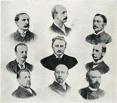
The British South Africa Company (BSAC or BSACo) was chartered in 1889 following the amalgamation of Cecil Rhodes' Central Search Association and the London-based Exploring Company Ltd, which had originally competed to capitalize on the expected mineral wealth of Mashonaland but united because of common economic interests and to secure British government backing. The company received a Royal Charter modelled on that of the British East India Company. Its first directors included The 2nd Duke of Abercorn, Rhodes himself, and the South African financier Alfred Beit. Rhodes hoped BSAC would promote colonisation and economic exploitation across much of south-central Africa, as part of the "Scramble for Africa". However, his main focus was south of the Zambezi, in Mashonaland and the coastal areas to its east, from which he believed the Portuguese could be removed by payment or force, and in the Transvaal, which he hoped would return to British control. It has been suggested that R ... [...More Info...] [...Related Items...] OR: [Wikipedia] [Google] [Baidu] |
Cecil Rhodes
Cecil John Rhodes (5 July 1853 – 26 March 1902) was a British mining magnate and politician in southern Africa who served as Prime Minister of the Cape Colony from 1890 to 1896. An ardent believer in British imperialism, Rhodes and his British South Africa Company colonised the southern African territory of Rhodesia (now Zimbabwe and Zambia), which the company named after him in 1895. South Africa's Rhodes University is also named after him. He also devoted much effort to realising his vision of a Cape to Cairo Railway through British territory. Rhodes set up the provisions of the Rhodes Scholarship, which is funded by his estate. The son of a vicar, Rhodes was born at Netteswell House, Bishop's Stortford, Hertfordshire. A sickly child, he was sent to South Africa by his family when he was 17 years old in the hope that the climate might improve his health. He entered the diamond trade at Kimberley in 1871, when he was 18, and, thanks to funding from Rothschild & Co, beg ... [...More Info...] [...Related Items...] OR: [Wikipedia] [Google] [Baidu] |
Alfred Sharpe
Sir Alfred Sharpe (19 May 1853 – 10 December 1935) was Commissioner and Consul-General for the British Central Africa Protectorate and first Governor of Nyasaland. He trained as a solicitor but was in turn a planter and a professional hunter before becoming a British colonial administrator. He was commissioner (a de facto governor) of the British Central Africa Protectorate from 1896 until 1907 and Governor of Nyasaland after the protectorate changed its name to Nyasaland in 1907 until his retirement in 1910. He was involved in some of the dramatic events which shaped south-Central Africa at the onset of colonialism. Background and early career Sharpe was born on 19 May 1853 at Lancaster, Lancashire, England. During his childhood his family moved from Lancaster, first to Wales and then to Switzerland and France as his father was a railway engineer, involved in railway construction in those countries. Sharpe was educated at Haileybury and Imperial Service College, near Hertfo ... [...More Info...] [...Related Items...] OR: [Wikipedia] [Google] [Baidu] |
Katanga Province
Katanga was one of the four large provinces created in the Belgian Congo in 1914. It was one of the eleven provinces of the Democratic Republic of the Congo between 1966 and 2015, when it was split into the Tanganyika Province, Tanganyika, Haut-Lomami, Lualaba Province, Lualaba, and Haut-Katanga provinces. Between 1971 and 1997 (during the rule of Mobutu Sese Seko when Congo was known as Zaire), its official name was Shaba Province. Katanga's area encompassed . Farming and ranching are carried out on the Katanga Plateau. The eastern part of the province is considered to be a rich mining region, which supplies cobalt, copper, tin, radium, uranium, and diamonds. The region's former capital, Lubumbashi, is the second-largest city in the Congo. History Copper mining in Katanga dates back over 1,000 years, and mines in the region were producing standard-sized ingots of copper for international transport by the end of the 10th century CE. In the 1890s, the province was beleaguered ... [...More Info...] [...Related Items...] OR: [Wikipedia] [Google] [Baidu] |

.jpg)


