|
Chemehuevi Indian Tribe Of The Chemehuevi Reservation, California
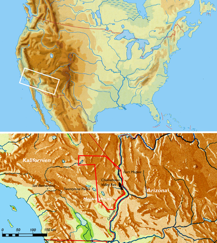
The Chemehuevi Indian Tribe of the Chemehuevi Reservation (Colorado River Numic language: Nüwüwü) is a federally recognized tribe of Chemehuevi people, who are the southernmost branch of Southern Paiute people. To celebrate their organization under the Indian Reorganization Act, tribal recognition, and ratifying their constitution, the tribe hosts Nuwuvi Days, an annual festival held during the first weekend in June. Reservation The Chemehuevi Reservation () is located in San Bernardino County, California, bordering Lake Havasu for and along the Colorado River. The reservation is large and has a population of 345. Government The Chemehuevi Indian Tribe's headquarters is located in Havasu Lake, California. The tribe is governed by a democratically elected, nine-member tribal council. Economic development The tribe owns and operates Havasu Landing Resort, Casino and Hotel on Lake Havasu, near Needles, California Needles is a city in San Bernardino County, California, i ... [...More Info...] [...Related Items...] OR: [Wikipedia] [Google] [Baidu] |
Indian Reorganization Act
The Indian Reorganization Act (IRA) of June 18, 1934, or the Wheeler–Howard Act, was U.S. federal legislation that dealt with the status of American Indians in the United States. It was the centerpiece of what has been often called the "Indian New Deal". The major goal was to reverse the traditional goal of cultural assimilation of Native Americans into American society and to strengthen, encourage and perpetuate the tribes and their historic Native American cultures in the United States. The Act also restored to Indians the management of their assets—land and mineral rights—and included provisions intended to create a sound economic foundation for the residents of Indian reservations. The law did not apply to the territories—including what would become the state of Hawaii, and the state of Alaska—nor did they apply to the state of Oklahoma, which until the McGirt case was regarded as having dissolved its reservations. In 1936 however, the rights of the Indigenous peop ... [...More Info...] [...Related Items...] OR: [Wikipedia] [Google] [Baidu] |
Native American Tribes In Arizona
The Indigenous peoples of Arizona are the Native Americans in the United States, Native American people of the state of Arizona. These include people that have lived in the region since time immemorial; tribes who entered the region centuries ago, such as the Southern Athabascan peoples; and the Pascua Yaqui who settled Arizona in mass in the early 20th century, though small communities had been in the region for hundreds of years prior. Arizona has the third largest Native American population of any U.S. state. Almost a quarter of Arizona is Indian reservation, reservation land. The Navajo Nation has the largest reservation in the United States, and the Tohono O'odham Nation in southeast Arizona has the second-largest reservation. There are 17 federally recognized tribes completely within the borders of Arizona, and 5 more in Arizona whose territory spans multiple states. Of these, 20 tribes are members of the Inter-Tribal Council of Arizona (ITCA). Native American tribes in ... [...More Info...] [...Related Items...] OR: [Wikipedia] [Google] [Baidu] |
Chemehuevi
The Chemehuevi are an indigenous people of the Great Basin. They are the southernmost branch of Southern Paiute."California Indians and Their Reservations." ''SDSU Library and Information Access.'' Retrieved 12 April 2010. Today, Chemehuevi people are enrolled in the following : * * [...More Info...] [...Related Items...] OR: [Wikipedia] [Google] [Baidu] |
Needles, California
Needles is a city in San Bernardino County, California, in the Mojave Desert region of Southern California. Situated on the western banks of the Colorado River, Needles is located near the Californian border with Arizona and Nevada. The city is accessible via Interstate 40 and U.S. Route 95. The population was 4,959 at the 2020 census, up from 4,844 at the 2010 census. History Needles was founded in May 1883 during the construction of the Atchison, Topeka and Santa Fe Railway, which originally crossed the Colorado River at Eastbridge, Arizona three miles southeast of modern Needles. Needles was named after "The Needles", a group of pinnacles in the Mohave Mountains on the Arizona side of the river. However, the crossing was a poor site for a bridge, lacking firm banks and a solid bottom. A bridge was actually built, but it was of poor quality. Not only was it a "flimsy looking structure", but it was also an obstacle to navigation on the river. The flooding of the Colorado R ... [...More Info...] [...Related Items...] OR: [Wikipedia] [Google] [Baidu] |
Havasu Lake, California
Havasu Lake is an unincorporated community in San Bernardino County, California, United States, located on Lake Havasu on the Chemehuevi Reservation in the Mojave Desert. The community serves as the seat of the tribal government of the Chemehuevi Indian Tribe The Chemehuevi Indian Tribe of the Chemehuevi Reservation ( Colorado River Numic language: Nüwüwü) is a federally recognized tribe of Chemehuevi people, who are the southernmost branch of Southern Paiute people. To celebrate their organizatio ... and is home to the Havasu Landing Casino. The Siwavaats Junior College in Lake Havasu teaches children the Chemehuevi language. Water is provided by the Havasu Water Company. Sanitation Services are provided by San Bernardino County Service area HL 70 Havasu Lake Students in Havasu Lake attend schools within the Needles Unified School District. Elementary School Students attend Chemehuevi Valley Elementary School References External linksOfficial Tribal Page [...More Info...] [...Related Items...] OR: [Wikipedia] [Google] [Baidu] |
Colorado River
The Colorado River ( es, Río Colorado) is one of the principal rivers (along with the Rio Grande) in the Southwestern United States and northern Mexico. The river drains an expansive, arid watershed that encompasses parts of seven U.S. states and two Mexican states. The name Colorado derives from the Spanish language for "colored reddish" due to its heavy silt load. Starting in the central Rocky Mountains of Colorado, it flows generally southwest across the Colorado Plateau and through the Grand Canyon before reaching Lake Mead on the Arizona–Nevada border, where it turns south toward the international border. After entering Mexico, the Colorado approaches the mostly dry Colorado River Delta at the tip of the Gulf of California between Baja California and Sonora. Known for its dramatic canyons, whitewater rapids, and eleven U.S. National Parks, the Colorado River and its tributaries are a vital source of water for 40 million people. An extensive system of dams ... [...More Info...] [...Related Items...] OR: [Wikipedia] [Google] [Baidu] |
Lake Havasu
Lake Havasu () is a large reservoir formed by Parker Dam on the Colorado River, on the border between San Bernardino County, California and Mohave County, Arizona, Arizona. Lake Havasu City sits on the Arizona (eastern) side of the lake with its Californian counterpart of Havasu Lake directly across the lake. The reservoir has an available capacity of . The concrete arch dam was built by the United States Bureau of Reclamation between 1934 and 1938. The lake's primary purpose is to store water for pumping into two aqueducts. Prior to the dam construction, the area was home to the Mojave people. The lake was named (in 1939) after the Mojave word for ''blue''. In the early 19th century, it was frequented by beaver trappers. Spaniards also began to mine the areas along the river. Aqueducts Mark Wilmer Pumping Plant pumps water into the Central Arizona Project Aqueduct. Whitsett Pumping Plant is located on the lake, and lifts the water for the Colorado River Aqueduct. Gene Pumpi ... [...More Info...] [...Related Items...] OR: [Wikipedia] [Google] [Baidu] |
San Bernardino County, California
San Bernardino County (), officially the County of San Bernardino, is a county located in the southern portion of the U.S. state of California, and is located within the Inland Empire area. As of the 2020 U.S. Census, the population was 2,181,654, making it the fifth-most populous county in California and the 14th-most populous in the United States. The county seat is San Bernardino. While included within the Greater Los Angeles area, San Bernardino County is included in the Riverside– San Bernardino–Ontario metropolitan statistical area, as well as the Los Angeles– Long Beach combined statistical area. With an area of , San Bernardino County is the largest county in the contiguous United States by area, although some of Alaska's boroughs and census areas are larger. The county is close to the size of West Virginia. This vast county stretches from where the bulk of the county population resides in three Census County Divisions (Fontana, San Bernardino, and Vi ... [...More Info...] [...Related Items...] OR: [Wikipedia] [Google] [Baidu] |
Southern Paiute
The Southern Paiute people are a tribe of Native Americans who have lived in the Colorado River basin of southern Nevada, northern Arizona, and southern Utah. Bands of Southern Paiute live in scattered locations throughout this territory and have been granted federal recognition on several reservations. The first European contact with the Southern Paiute occurred in 1776, when fathers Silvestre Vélez de Escalante and Francisco Atanasio Domínguez encountered them during an attempt to find an overland route to the missions of California. They noted that some of the Southern Paiute men "had thick beards and were thought to look more in appearance like Spanish men than native Americans". Before this date, the Southern Paiute suffered slave raids by the Navajo and the Ute. The arrival of Spanish and later Euro-American explorers into their territory increased slave raiding by other tribes. In 1851, Mormon settlers strategically occupied Paiute water sources, which created ... [...More Info...] [...Related Items...] OR: [Wikipedia] [Google] [Baidu] |
Native American Church
The Native American Church (NAC), also known as Peyotism and Peyote Religion, is a Native American religion that teaches a combination of traditional Native American beliefs and Christianity, with sacramental use of the entheogen peyote. The religion originated in the Oklahoma Territory (1890–1907) in the late nineteenth century, after peyote was introduced to the southern Great Plains from Mexico. Today it is the most widespread indigenous religion among Native Americans in the United States (except Alaska Natives and Native Hawaiians), Canada (specifically First Nations people in Saskatchewan and Alberta), and Mexico, with an estimated 250,000 adherents as of the late twentieth century. History Historically, many denominations of mainstream Christianity made attempts to convert Native Americans to Christianity in the Western Hemisphere. These efforts were partially successful, for many Native American tribes reflect Christian creed, including the Native American Church. ... [...More Info...] [...Related Items...] OR: [Wikipedia] [Google] [Baidu] |
Federally Recognized Tribes
This is a list of federally recognized tribes in the contiguous United States of America. There are also federally recognized Alaska Native tribes. , 574 Indian tribes were legally recognized by the Bureau of Indian Affairs (BIA) of the United States.Federal Acknowledgment of the Pamunkey Indian Tribe Of these, 231 are located in Alaska. Description  In the United States, the Indian tribe is a fundamental unit, and the constitution grants
 [...More Info...] [...Related Items...] OR: [Wikipedia] [Google] [Baidu] |


.jpg)

