|
Central Brandenburg Plateaux And Lowlands
The Central Brandenburg Plateaux and Lowlands (german: Mittelbrandenburgische Platten und Niederungen) form a natural region in the German state of Brandenburg and in parts of southwest Berlin and the east of Saxony-Anhalt. They are major unit group 81 in the system of natural regions of Germany and part of the East German Plateaux and Heathlands. The Brandenburg portion of the Central Brandenburg Plateaux and Lowlands is largely coincident with the natural region designated as the Central March (''Mittlere Mark'') in the structural atlas of the state of Brandenburg. Location The Central Brandenburg Plateaux and Lowlands are part of the North German Plain. Neighbouring landscapes are the Luchland to the north, the East Brandenburg Heath and Lake District to the east, the Spreewald and the Lusatian Basin and Heathland to the southeast, the Fläming to the south and the Elbe Valley to the west. Description Almost all the landscape elements that originated during the ... [...More Info...] [...Related Items...] OR: [Wikipedia] [Google] [Baidu] |
Golm (Potsdam)
Golm is a locality (''Ortsteil'') of Potsdam, the capital of the German state of Brandenburg. The former municipality was incorporated in 2003. Its name is derived from Western Slavic ''chulm'', meaning "hill", and refers to one of the nearby elevations, either ''Reiherberg'' ( a.s.l.) near the centre of the original village or ''Ehrenpfortenberg'' ( a.s.l.) east of it. Geography Neighbouring localities are Grube and Bornim in the north, Eiche in the east (all of which are now parts of Potsdam), and Wildpark West, a part of Geltow in Schwielowsee municipality, in the south. To the west, Golm is bordered by '' Großer Zernsee'', a lake in the course of the river Havel. The settlement of Kuhfort, bordering the Wildpark area of Potsdam, is located southeast of Golm, and east of the grassland of ''Golmer Luch''. Buildings and structures Golm houses, among other things, since 1991 a complex of the University of Potsdam on the premises of former Luftwaffe and Reichsarbeitsdien ... [...More Info...] [...Related Items...] OR: [Wikipedia] [Google] [Baidu] |
Kleiner Ravensberg
Kleiner Ravensberg is the highest elevation in the municipal area of Potsdam in Brandenburg, Germany with a peak at 114.2 m above sea level. It is located in a woodland called ''Ravensberge''. The hill is part of a push moraine which was formed during the Weichselian glaciation The Weichselian glaciation was the last glacial period and its associated glaciation in northern parts of Europe. In the Alpine region it corresponds to the Würm glaciation. It was characterized by a large ice sheet (the Fenno-Scandian ice sheet) .... Hills of Brandenburg {{Brandenburg-geo-stub ... [...More Info...] [...Related Items...] OR: [Wikipedia] [Google] [Baidu] |
Push Moraine
A push moraine or pushed moraine is in geomorphology a moraine (a landform formed by glacial processes) that forms when the terminus advance of a lowland glacier pushes unstratified glacial sediment into a pile or linear ridge in front of it. A push moraine is identified by its ability to push sediment upwards from its original horizontal position. Push moraines are limited in size by the advance of a glacier front and its tendency to shear over the top of any ridge large enough to resist the movement of ice. Pushed moraines generally occur in low, flat plains at higher latitudes and were formed during the glacial stages of the Quaternary ice age. They can be up to 100 km long and several hundreds of metres in height. Pushed moraines can be found in the North American plains, in Siberia and in Northern Europe. They were formed during cool, glacial stages, when glaciers advanced and covered large parts of North America and Eurasia. In some regions pushed moraines of more than o ... [...More Info...] [...Related Items...] OR: [Wikipedia] [Google] [Baidu] |
Urstromtal
An ''urstromtal'' (plural: ''Urstromtäler'') is a type of broad glacial valley, for example, in northern Central Europe, that appeared during the ice ages, or individual glacial periods of an ice age, at the edge of the Scandinavian ice sheet and was formed by meltwaters that flowed more or less parallel to the ice margin. ''Urstromtäler'' are an element of the glacial series. The term is German and means "ancient stream valley". Although often translated as "glacial valley", it should not be confused with a valley carved out by a glacier. More accurately some sources call them "meltwater valleys" or "ice-marginal valleys". Emergence and structure Important for the emergence of the ''Urstromtäler'' is the fact that the general lie of the land on the North German Plain and in Poland slopes down from south to north. Thus the ice sheet that advanced from Scandinavia flowed into a rising terrain. The meltwaters could therefore only flow for a short distance southwards over the sa ... [...More Info...] [...Related Items...] OR: [Wikipedia] [Google] [Baidu] |
Teltow (landscape)
Teltow [] is both a geological plateau and also a historical region in the German states of Brandenburg and Berlin. As an historical region, the Teltow was one of the eight territories out of which the March of Brandenburg was formed in the 12th and 13th centuries. As a result of the (1239–1245) the question of territorial lordship of the newly created heart of the expanding march was finally decided here. Between 1835 and 1952 there was also a county, ; in addition a town immediately south of Berlin, in the present-day county of Potsdam-Mittelmark, bears the name Teltow. Geography and geology Boundary The Teltow is not a unified region, either from a historical or a landscape perspective. The present-day term is defined by an ice age plateau that consists mainly of ground moraine elements. Its natural northern border is defined by the range of the Tempelhofer Berge, among them the Kreuzberg rising to , along the southern bank of the Spree. To the east the border ... [...More Info...] [...Related Items...] OR: [Wikipedia] [Google] [Baidu] |
Nauen Plateau
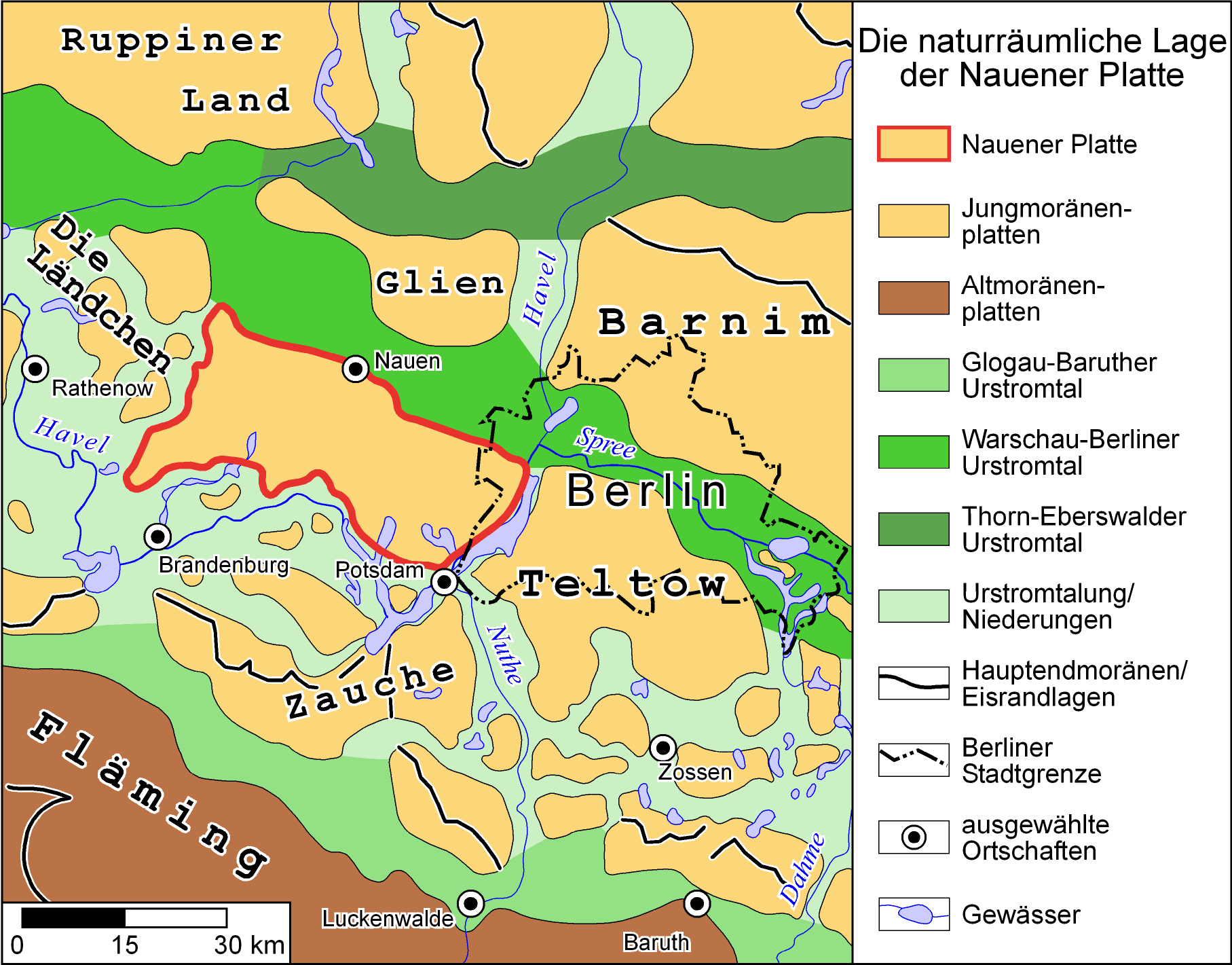
The Nauen Plateau (german: Nauener Platte) is a low plateau in the German states of Brandenburg and Berlin. It rises above the surrounding countryside by an average of and is a largely contiguous upland area that was formed during the Saale and Weichselian glaciations. It consists predominantly of ground moraine deposits, partly overlain by gently rolling end moraine formations. Whilst the neighbouring regions of Zauche to the south, the Teltow to the southeast and the Barnim to the northeast have the same name as their geological formation, the cultural landscape on the Nauen Plateau bears the historical and regional name of Havelland. That said, the river country of the Havelland extends beyond the plateau to include the Havel valley and other lowland areas. Location The Nauen Plateau lies in the central Mark and in the extreme west of the state of Berlin. Its northern boundary is formed by a glacial meltwater valley, the Berlin Urstromtal, and by the former marshlands of the ... [...More Info...] [...Related Items...] OR: [Wikipedia] [Google] [Baidu] |
Weichselian Glaciation
The Weichselian glaciation was the last glacial period and its associated glaciation in northern parts of Europe. In the Alpine region it corresponds to the Würm glaciation. It was characterized by a large ice sheet (the Fenno-Scandian ice sheet) that spread out from the Scandinavian Mountains and extended as far as the east coast of Schleswig-Holstein, northern Poland and Northwest Russia. This glaciation is also known as the Weichselian ice age (german: Weichsel-Eiszeit), Vistulian glaciation, Weichsel or, less commonly, the Weichsel glaciation, Weichselian cold period (''Weichsel-Kaltzeit''), Weichselian glacial (''Weichsel-Glazial''), ''Weichselian Stage'' or, rarely, the Weichselian complex (''Weichsel-Komplex''). In Northern Europe it was the youngest of the glacials of the Pleistocene ice age. The preceding warm period in this region was the Eemian interglacial. The last cold period began about 115,000 years ago and ended 11,700 years ago. Its end corresponds with the end o ... [...More Info...] [...Related Items...] OR: [Wikipedia] [Google] [Baidu] |
Spreewald
The Spree Forest (German: ''Spreewald'', ; Lower Sorbian: ''Błota'', i.e. 'the Swamps') is a large inland delta of the river Spree, and a historical cultural landscape located in the region of (Lower) Lusatia, in the state of Brandenburg, Germany, about 100 km southeast of Berlin and close to the city of Cottbus ( L.S. Chóśebuz). The Spree Forest is located within the settlement area of the (Lower) Sorbs, and the region is officially bilingual, German and Lower Sorbian. As extensive floodplain and bog landscape, the Spree Forest was designated a biosphere reserve by UNESCO in 1991, called ''Biosphärenreservat Spreewald'' (''biosferowy rezerwat Błota''). It is known for its traditional irrigation system, consisting of more than 200 small canals (called ''Fließe''; total length: ) within the area, for its unique flora and fauna, and for its traditional flat-bottomed boats, the ''Spreewaldkähne''. The landscape was shaped during the last Ice Age. The region's mo ... [...More Info...] [...Related Items...] OR: [Wikipedia] [Google] [Baidu] |
North German Plain
The North German Plain or Northern Lowland (german: Norddeutsches Tiefland) is one of the major geographical regions of Germany. It is the German part of the North European Plain. The region is bounded by the coasts of the North Sea and the Baltic Sea to the north, Germany's Central Uplands (''die Mittelgebirge'') to the south, by the Netherlands to the west and Poland to the east. In the west, the southern boundary of the North German Plain is formed by the Lower Saxon Hills: specifically the ridge of the Teutoburg Forest, the Wiehen Hills, the Weser Hills and the Lower Saxon Börde, which partly separate it from that area of the Plain known as the Westphalian Lowland. Elements of the Rhenish Massif also act a part of the southern boundary of the plain: the Eifel, Bergisches Land and the Sauerland. In the east the North German Plain spreads out beyond the Harz Mountains and Kyffhäuser further to the south as far as the Central Saxon hill country and the foothills of the Ore M ... [...More Info...] [...Related Items...] OR: [Wikipedia] [Google] [Baidu] |


