|
Andreanof Islands
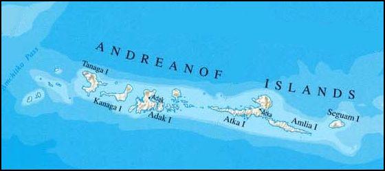
The Andreanof Islands ( ale, Niiĝuĝim tanangis, russian: Андреяновские острова) are a group of islands in the Aleutian Islands in southwestern Alaska. They are located at about 52° North and 172°57' to 179°09' West. Geography The Andreanof Islands are located between Amchitka Pass and the Rat Islands group to the west, and Amukta Pass and the Islands of Four Mountains group to the east. The islands extend about 275 miles (440 km). The total land area of all islands (including the Delarof Islands) is 1,515.349 sq mi (3,924.737 km2). The total population was 412 persons as of the 2000 census, the vast majority in the city of Adak on Adak Island. Islands The Delarof Islands are a subgroup of the Andreanof Islands group as well as the westernmost islands in the group. The largest islands in the group are, from west to east, Gareloi Island, Tanaga Island, Kanaga, Adak Island, Kagalaska Island, Great Sitkin Island, Atka Island, Amlia, and Seg ... [...More Info...] [...Related Items...] OR: [Wikipedia] [Google] [Baidu] |
Kanaga Island
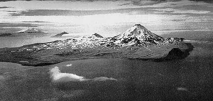
Kanaga Island ( ale, Kanaga; russian: Остров Канага) is a part of the Andreanof Islands group of the Aleutian Islands in Alaska. The island measures long and between wide with an area of , making it the 42nd largest island in the United States. The island's most notable feature is Mount Kanaga, a volcano which last erupted in 1995. Gallery References "Kanaga Island" ''Encyclopædia Britannica The (Latin for "British Encyclopædia") is a general knowledge English-language encyclopaedia. It is published by Encyclopædia Britannica, Inc.; the company has existed since the 18th century, although it has changed ownership various time ...''. Retrieved July 7, 2005. Andreanof Islands Islands of Alaska Islands of Unorganized Borough, Alaska {{AleutiansWestAK-geo-stub ... [...More Info...] [...Related Items...] OR: [Wikipedia] [Google] [Baidu] |
Islands Of The Aleutian Islands
An island (or isle) is an isolated piece of habitat that is surrounded by a dramatically different habitat, such as water. Very small islands such as emergent land features on atolls can be called islets, skerry, skerries, cays or keys. An river island, island in a river or a lake island may be called an ait, eyot or ait, and a small island off the coast may be called a holm (island), holm. Sedimentary islands in the Ganges delta are called List of islands of Bangladesh, chars. A grouping of geographically or geologically related islands, such as the Philippines, is referred to as an archipelago. There are two main types of islands in the sea: continental and oceanic. There are also artificial islands, which are man-made. Etymology The word ''island'' derives from Middle English ''iland'', from Old English ''igland'' (from ''ig'' or ''ieg'', similarly meaning 'island' when used independently, and -land carrying its contemporary meaning; cf. Dutch language, Dutch ''eiland'' ... [...More Info...] [...Related Items...] OR: [Wikipedia] [Google] [Baidu] |
Islands Of Aleutians West Census Area, Alaska
An island (or isle) is an isolated piece of habitat that is surrounded by a dramatically different habitat, such as water. Very small islands such as emergent land features on atolls can be called islets, skerries, cays or keys. An island in a river or a lake island may be called an eyot or ait, and a small island off the coast may be called a holm. Sedimentary islands in the Ganges delta are called chars. A grouping of geographically or geologically related islands, such as the Philippines, is referred to as an archipelago. There are two main types of islands in the sea: continental and oceanic. There are also artificial islands, which are man-made. Etymology The word ''island'' derives from Middle English ''iland'', from Old English ''igland'' (from ''ig'' or ''ieg'', similarly meaning 'island' when used independently, and -land carrying its contemporary meaning; cf. Dutch ''eiland'' ("island"), German ''Eiland'' ("small island")). However, the spelling of the word ... [...More Info...] [...Related Items...] OR: [Wikipedia] [Google] [Baidu] |
Andreanof Islands
The Andreanof Islands ( ale, Niiĝuĝim tanangis, russian: Андреяновские острова) are a group of islands in the Aleutian Islands in southwestern Alaska. They are located at about 52° North and 172°57' to 179°09' West. Geography The Andreanof Islands are located between Amchitka Pass and the Rat Islands group to the west, and Amukta Pass and the Islands of Four Mountains group to the east. The islands extend about 275 miles (440 km). The total land area of all islands (including the Delarof Islands) is 1,515.349 sq mi (3,924.737 km2). The total population was 412 persons as of the 2000 census, the vast majority in the city of Adak on Adak Island. Islands The Delarof Islands are a subgroup of the Andreanof Islands group as well as the westernmost islands in the group. The largest islands in the group are, from west to east, Gareloi Island, Tanaga Island, Kanaga, Adak Island, Kagalaska Island, Great Sitkin Island, Atka Island, Amlia, and Seg ... [...More Info...] [...Related Items...] OR: [Wikipedia] [Google] [Baidu] |
1957 Andreanof Islands Earthquake
The 1957 Andreanof Islands earthquake took place on March 9 with a moment magnitude of 8.6 and a maximum Mercalli intensity of VIII (''Severe''). It occurred south of the Andreanof Islands group, which is part of the Aleutian Islands arc. The event occurred along the Aleutian Trench, the convergent plate boundary that separates the Pacific Plate and the North American Plates near Alaska. A basin wide tsunami followed, with effects felt in Alaska and Hawaii. Total losses were around $5 million. Tectonic setting The Aleutian Subduction Zone is the convergent boundary of the Pacific and North American Plates. This oceanic trench runs from the Kuril Subduction Zone in the west to the Yakutat Collision Zone in the east. At each end of the subduction zone are right-lateral transform faults, including the Queen Charlotte Fault in the east, and a similar structure at the far west end of the arc near Attu Island. Earthquake Because the shock occurred before the World Wide Standardised ... [...More Info...] [...Related Items...] OR: [Wikipedia] [Google] [Baidu] |
World War II
World War II or the Second World War, often abbreviated as WWII or WW2, was a world war that lasted from 1939 to 1945. It involved the vast majority of the world's countries—including all of the great powers—forming two opposing military alliances: the Allies and the Axis powers. World War II was a total war that directly involved more than 100 million personnel from more than 30 countries. The major participants in the war threw their entire economic, industrial, and scientific capabilities behind the war effort, blurring the distinction between civilian and military resources. Aircraft played a major role in the conflict, enabling the strategic bombing of population centres and deploying the only two nuclear weapons ever used in war. World War II was by far the deadliest conflict in human history; it resulted in 70 to 85 million fatalities, mostly among civilians. Tens of millions died due to genocides (including the Holocaust), starvation, ma ... [...More Info...] [...Related Items...] OR: [Wikipedia] [Google] [Baidu] |
Seguam Island
Seguam Island ( ale, Saĝuugamax; russian: Остров Сигуам) is a small volcanic island in the Andreanof Islands group in the Aleutian Islands of Alaska. The island is mountainous and oval shaped with a land area of . It is long and wide. The 2000 census reported a population of one person. The island consists of several overlapping stratovolcanoes, and it contains two calderas each with central volcanic cones. About 10 historical eruptions have been recorded since the late 18th century, the most recent in 1993. All recent activity has occurred at Pyre Peak, the cone within the western caldera and the highest point on the island, and has produced explosive eruptions and basaltic lava flow Lava is molten or partially molten rock (magma) that has been expelled from the interior of a terrestrial planet (such as Earth) or a moon onto its surface. Lava may be erupted at a volcano or through a fracture in the crust, on land or und ...s. References Further re ... [...More Info...] [...Related Items...] OR: [Wikipedia] [Google] [Baidu] |
Amlia
Amlia ( ale, Amlax; russian: Остров Амля) is an island in the Aleutian Islands. It is located near the eastern end of the Andreanof Islands and is situated between Atka Island and Seguam Island Seguam Island ( ale, Saĝuugamax; russian: Остров Сигуам) is a small volcanic island in the Andreanof Islands group in the Aleutian Islands of Alaska. The island is mountainous and oval shaped with a land area of . It is long and wi .... The island is long and wide, with a land area of 172.1 sq mi (445.7 km2), making it the 36th largest island in the United States. It has a rough terrain and reaches at its highest point. There is no permanent resident population. Amlia Island is the second-largest uninhabited island in the Aleutian Islands. Nearby islands include Agligadak, Sagigik and Tanadak. References Further readingAmlia Island: Block 1084, Census Tract 1, Aleutians West Census Area, AlaskaUnited States Census Bureau * Alaska Maritime National W ... [...More Info...] [...Related Items...] OR: [Wikipedia] [Google] [Baidu] |
Atka Island
Atka Island ( ale, Atx̂ax̂, russian: Атка остров) is the largest island in the Andreanof Islands of the Aleutian Islands of Alaska. The island is east of Adak Island. It is long and wide with a land area of , making it the 22nd largest island in the United States. The northeast of Atka Island contains the Korovin volcano which reaches a peak of . Oglodak Island is located off Cape Kigun, Atka's westernmost point. The city of Atka, Alaska is on the east side of the island. The 2000 census population of the island was 95 persons, almost all in the city of Atka.Atka Island: Blocks 1085 thru 1100 and Block 1103, Census Tract 1, Aleutians West Census Area, Alaska United States Census Bureau On December 5, 2008, |
Great Sitkin Island
Great Sitkin Island ( ale, Sitх̑naх̑; russian: Большой Ситкин) is a volcanic island in the Andreanof Islands of the Aleutian Islands of Alaska. The island covers a total area of and lies slightly north of a group of islands which are located between Adak Island and Atka Island. The northern portion of the island is dominated by the complex Great Sitkin Volcano which rises to a height of . The island is long and wide. History Great Sitkin was the site of a fuel depot during World War II, Sand Bay Naval Station, construction finished on May 15, 1943, and included accommodations for up to 680 men and consisted of 26 fuel oil tanks, three 6,000 barrel tanks, 22 10,000 barrel tanks and one 15,000 barrel tank and were surrounded by berms in case of attack or spills. The Naval Station had only around 10 people supporting it by 1949, but was in operation until 1963 and the remains of the oil tanks are still on the island and are an environmental hazard. Starting i ... [...More Info...] [...Related Items...] OR: [Wikipedia] [Google] [Baidu] |
Kagalaska Island
Kagalaska Island ( ale, Qigalaxsix̂; russian: Кагаласка) is an island in the Andreanof Islands of the Aleutian Islands of Alaska. The island is in length and wide. It is separated from Adak Island to the west by Kagalaska Strait (Aakayuudax̂ in Aleut) which is approximately wide at its narrowest point. Little Tanaga Island Little Tanaga Island ( ale, Tanagax̂) is an island located in the Andreanof Islands of the Aleutian Islands of Alaska. It lies between Kagalaska Island Kagalaska Island ( ale, Qigalaxsix̂; russian: Кагаласка) is an island in the Andre ... is located to the east, across Little Tanaga Strait.NOS nautical chart #16475 The island is covered in scrub brush and sand dunes, unlike other Alaskan islands that have hardscrabble coasts. It provides nesting grounds for sea birds and in the summer is a basking site for seals. References Andreanof Islands Islands of Alaska Islands of Unorganized Borough, Alaska {{AleutiansWestA ... [...More Info...] [...Related Items...] OR: [Wikipedia] [Google] [Baidu] |


