|
Bushahr
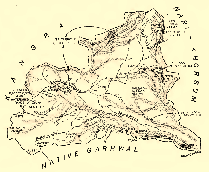
Bushahr, also spelt as 'Bashahr' and 'Bussahir' or 'Bushair' was a Rajput princely state in India during the British Raj. It was located in the hilly western Himalaya promontory bordering Tibet in the northern part of colonial Punjab region. The territory of this former state is now part of Kinnaur and Shimla districts of the present Himachal Pradesh state. The erstwhile Bushahr state was traversed by the Sutlej river. It was bordered on the west by the Kulu, Lahaul and Spiti states and by Tehri Garhwal on the east. It had an area of . History The erstwhile Bushahr state was occupied by a Gorkha king from central Nepal from 1803 to 1815. Ranjit Singh, the ruler of the Sikh state in the Punjab, intervened in 1809 and drove the Nepalese army east of the Satluj river. A rivalry between Nepal and the British East India Company over the annexation of minor states bordering Nepal eventually led to the Anglo-Nepalese War (1815–16) or the Gurkha War. Both parties eventually sig ... [...More Info...] [...Related Items...] OR: [Wikipedia] [Google] [Baidu] |
Rampur, Himachal Pradesh
Rampur Bushahr is a town and a municipal council in Shimla district in the Indian state of Himachal Pradesh. It is about 130 km from Shimla and is well connected with NH 5 which passes through Theog, Narkanda and Kumarsain. History The principality of Bushahr (also known as Bashahar, Bushahar, Bashahr) was once among the largest of the twenty-eight Shimla Hill States under the administration of the British Raj keen to invest on regional and transcontinental trade and exploit Himalayan resources. Caught in one of the British imperial enterprise, it was subjected to political-cum-economic vicissitudes, acceding to the Indian Union in 1947. On 8 March 1948, along with twenty other princely hill States of Punjab and Shimla, Bashahr signed an agreement which resulted in its inclusion in the Indian State of Himachal Pradesh. Rampur, a small township situated at 1,005 meters on the left bank of the Sutlej, served as Bushahar's winter capital. Being well connected with major t ... [...More Info...] [...Related Items...] OR: [Wikipedia] [Google] [Baidu] |
Sarahan
Sarahan is a small town in Himachal Pradesh of India. It is the site of the Bhimakali Temple, originally known as Bhimadevi Temple (Bhīmā Kālī), dedicated to the mother goddess Bhimakali, presiding deity of the rulers of the former Bushahr State. The temple is situated about 170 kilometres from Shimla and is one of 51 Shakti Peethas. The town is known as the "gateway of Kinnaur" it being near the old Indo-Tibetan Road. Seven kilometers below (17 km by road) Sarahan is the river Satluj. Sarahan is identified with the Shonitpur mentioned in Puranas. Sarahan Bushahr has been the summer capital of Bushahr kingdom, with Rampur Bushahr considered the winter capital. The former Chief Minister of Himachal Pradesh Shree Virbhadra Singh is a member of royal family (Son of erstwhile king Padam Singh) and is popularly known as "Raja Sahab" at Sarahann. He has been member of the Assembly/Parliament since 1962 and has held the post of Chief Minister six times. His wife Rani Prati ... [...More Info...] [...Related Items...] OR: [Wikipedia] [Google] [Baidu] |
Kinnaur
Kinnaur is one of the twelve administrative districts of the state of Himachal Pradesh in northern India. The district is divided into three administrative areas (Kalpa, Nichar (Bhabanagar), and Pooh) and has six tehsils. The administrative headquarters of the district is at Reckong Peo. The mountain peak of Kinnaur Kailash is found in this district. As of 2011, it is the second least populous district of Himachal Pradesh (out of 12 districts), after Lahaul and Spiti. General Kinnaur is about from the state capital, Shimla, located in the northeast corner of Himachal Pradesh bordering Tibet to the east. It has three high mountain ranges, namely Zanskar and the Himalayas, that enclose the valleys of Baspa, Satluj, and Spiti, as well as their tributaries. The slopes are covered with thick wood, orchards, fields and hamlets. At the peak of Kinnaur Kailash mountain is a natural rock Shivling (Shiva lingam). The district was opened to outsiders in 1989. The old Hindustan-Tibet R ... [...More Info...] [...Related Items...] OR: [Wikipedia] [Google] [Baidu] |
Himachal Pradesh
Himachal Pradesh (; ; "Snow-laden Mountain Province") is a state in the northern part of India. Situated in the Western Himalayas, it is one of the thirteen mountain states and is characterized by an extreme landscape featuring several peaks and extensive river systems. Himachal Pradesh is the northernmost state of India and shares borders with the union territories of Jammu and Kashmir and Ladakh to the north, and the states of Punjab to the west, Haryana to the southwest, Uttarakhand to the southeast and a very narrow border with Uttar Pradesh to the south. The state also shares an international border to the east with the Tibet Autonomous Region in China. Himachal Pradesh is also known as , meaning 'Land of Gods' and which means 'Land of the Brave'. The predominantly mountainous region comprising the present-day Himachal Pradesh has been inhabited since pre-historic times, having witnessed multiple waves of human migrations from other areas. Through its history, the ... [...More Info...] [...Related Items...] OR: [Wikipedia] [Google] [Baidu] |
Ranjit Singh
Ranjit Singh (13 November 1780 – 27 June 1839), popularly known as Sher-e-Punjab or "Lion of Punjab", was the first Maharaja of the Sikh Empire, which ruled the northwest Indian subcontinent in the early half of the 19th century. He survived smallpox in infancy but lost sight in his left eye. He fought his first battle alongside his father at age 10. After his father died, he fought several wars to expel the Afghans in his teenage years and was proclaimed as the "Maharaja of Punjab" at age 21. His empire grew in the Punjab region under his leadership through 1839. Prior to his rise, the Punjab region had numerous warring misls, misls (confederacies), twelve of which were under Sikh rulers and one Muslim. Ranjit Singh successfully absorbed and united the Sikh misls and took over other local kingdoms to create the Sikh Empire. He repeatedly defeated Afghan-Sikh Wars, invasions by outside armies, particularly those arriving from Afghanistan, and established friendly relat ... [...More Info...] [...Related Items...] OR: [Wikipedia] [Google] [Baidu] |
Sikh Empire
The Sikh Empire was a state originating in the Indian subcontinent, formed under the leadership of Maharaja Ranjit Singh, who established an empire based in the Punjab. The empire existed from 1799, when Maharaja Ranjit Singh captured Lahore, to 1849, when it was defeated and conquered in the Second Anglo-Sikh War. It was forged on the foundations of the Khalsa from a collection of autonomous Sikh ''misls''. At its peak in the 19th century, the Empire extended from the Khyber Pass in the west to western Tibet in the east, and from Mithankot in the south to Kashmir in the north. It was divided into four provinces: Lahore, in Punjab, which became the Sikh capital; Multan, also in Punjab; Peshawar; and Kashmir from 1799 to 1849. Religiously diverse, with an estimated population of 3.5 million in 1831 (making it the 19th most populous country at the time), Amarinder Singh's The Last Sunset: The Rise and Fall of the Lahore Durbar it was the last major region of the Indian subc ... [...More Info...] [...Related Items...] OR: [Wikipedia] [Google] [Baidu] |
Satluj
The Sutlej or Satluj River () is the longest of the five rivers that flow through the historic crossroads region of Punjab in northern India and Pakistan. The Sutlej River is also known as ''Satadru''. It is the easternmost tributary of the Indus River. The Bhakra Dam is built around the river Sutlej to provide irrigation and other facilities to the states of Punjab, Rajasthan and Haryana. The waters of the Sutlej are allocated to India under the Indus Waters Treaty between India and Pakistan, and are mostly diverted to irrigation canals in India like the Sirhind Canal, Bhakra Main Line and the Rajasthan canal. The mean annual flow is 14 million acre feet (MAF) upstream of Ropar barrage, downstream of the Bhakra dam. It has several major hydroelectric points, including the 1,325 MW Bhakra Dam, the 1,000 MW Karcham Wangtoo Hydroelectric Plant, and the 1,500 MW Nathpa Jhakri Dam. The drainage basin in India includes the states and union territories of Himachal Pr ... [...More Info...] [...Related Items...] OR: [Wikipedia] [Google] [Baidu] |
British East India Company
The East India Company (EIC) was an English, and later British, joint-stock company founded in 1600 and dissolved in 1874. It was formed to trade in the Indian Ocean region, initially with the East Indies (the Indian subcontinent and Southeast Asia), and later with East Asia. The company seized control of large parts of the Indian subcontinent, colonised parts of Southeast Asia and Hong Kong. At its peak, the company was the largest corporation in the world. The EIC had its own armed forces in the form of the company's three Presidency armies, totalling about 260,000 soldiers, twice the size of the British army at the time. The operations of the company had a profound effect on the global balance of trade, almost single-handedly reversing the trend of eastward drain of Western bullion, seen since Roman times. Originally chartered as the "Governor and Company of Merchants of London Trading into the East-Indies", the company rose to account for half of the world's trade duri ... [...More Info...] [...Related Items...] OR: [Wikipedia] [Google] [Baidu] |
Anglo-Nepalese War
The Anglo-Nepalese War (1 November 1814 – 4 March 1816), also known as the Gorkha War, was fought between the Gorkhali army of the Kingdom of Nepal (present-day Nepal) and the British forces of the East India Company (EIC, present-day India). Both sides had ambitious expansion plans for the mountainous north of the Indian subcontinent. The war ended with the signing of the Treaty of Sugauli in 1816 AD, which ceded some Nepalese controlled territory to the EIC. The British war effort was led by the East India Company and supported by a coalition of native states; the Garhwal Kingdom, the Patiala State and the Kingdom of Sikkim against the Kingdom of Gorkha. The Kingdom of Gorkha's war effort was led mostly by the two Thapa families; Thapa dynasty and Family of Amar Singh Thapa. Historical background The Shah era of Nepal began with the Gorkha king Prithvi Narayan Shah invading Kathmandu valley, which consisted of the capital of the Malla confederacy. Until that time only ... [...More Info...] [...Related Items...] OR: [Wikipedia] [Google] [Baidu] |
Gurkha War
The Anglo-Nepalese War (1 November 1814 – 4 March 1816), also known as the Gorkha War, was fought between the Gorkhali army of the Kingdom of Nepal (present-day Nepal) and the British forces of the East India Company (EIC, present-day India). Both sides had ambitious expansion plans for the mountainous north of the Indian subcontinent. The war ended with the signing of the Treaty of Sugauli in 1816 AD, which ceded some Nepalese controlled territory to the EIC. The British war effort was led by the East India Company and supported by a coalition of native states; the Garhwal Kingdom, the Patiala State and the Kingdom of Sikkim against the Kingdom of Gorkha. The Kingdom of Gorkha's war effort was led mostly by the two Thapa families; Thapa dynasty and Family of Amar Singh Thapa. Historical background The Shah era of Nepal began with the Gorkha king Prithvi Narayan Shah invading Kathmandu valley, which consisted of the capital of the Malla confederacy. Until that time only ... [...More Info...] [...Related Items...] OR: [Wikipedia] [Google] [Baidu] |
Gurkha
The Gurkhas or Gorkhas (), with endonym Gorkhali ), are soldiers native to the Indian Subcontinent, chiefly residing within Nepal and some parts of Northeast India. The Gurkha units are composed of Nepalis and Indian Gorkhas and are recruited for the Nepali Army (96000), Indian Army (42000), British Army (4010), Gurkha Contingent Singapore, Gurkha Reserve Unit Brunei, UN peacekeeping forces and in war zones around the world. Gurkhas are closely associated with the ''khukuri'', a forward-curving knife, and have a reputation for military prowess. Former Indian Army Chief of Staff Field Marshal Sam Manekshaw once stated that: "If a man says he is not afraid of dying, he is either lying or he is a Gurkha." Origins Historically, the terms "Gurkha" and "Gorkhali" were synonymous with "Nepali", which originates from the hill principality Gorkha Kingdom, from which the Kingdom of Nepal expanded under Prithvi Narayan Shah. The name may be traced to the medieval Hindu warrior-sai ... [...More Info...] [...Related Items...] OR: [Wikipedia] [Google] [Baidu] |
Sugauli Treaty
The Treaty of Sugauli (also spelled Sugowlee, Sagauli and Segqulee), the treaty that established the boundary line of Nepal, was signed on 4 March 1816 between the East India Company and Guru Gajaraj Mishra following the Anglo-Nepalese War of 1814–16. Background Following the Unification of Nepal under Prithvi Narayan Shah, Nepal attempted to enlarge its domains, conquering much of Sikkim in the east and, in the west, the basins of Gandaki and Karnali and the Uttarakhand regions of Garhwal and Kumaon. This brought them in conflict with the British, who controlled directly or indirectly the north Indian plains between Delhi and Calcutta. A series of campaigns termed the Anglo-Nepalese War occurred in 1814–1816. In 1815 the British general Ochterlony evicted the Nepalese from Garhwal and Kumaon across the Kali River, ending their 12-year occupation, which is remembered for its brutality and repression. Octherlony offered peace terms to the Nepalese demanding British ... [...More Info...] [...Related Items...] OR: [Wikipedia] [Google] [Baidu] |


