|
Burwell Castle
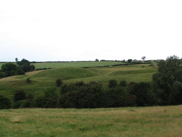
Burwell Castle was an unfinished medieval enclosure castle in Burwell, Cambridgeshire, England. Details Burwell Castle was built near the village of Burwell in 1143 by Stephen I of England, on the site of a former Roman villa. It was constructed during the civil war of the Anarchy, a long running dispute between the supporters of Stephen, and his Angevin rival, the Empress Matilda. The baron Geoffrey de Mandeville was dispossessed of his castles by Stephen and rose up in revolt immediately afterwards, taking up a position near Ely in the Fens and threatening Cambridge Castle and the route south to London; Burwell Castle was built as part of a chain of castles to protect the region, including fortifications at Lidgate, Rampton, Caxton, Swavesey and possibly Knapwell. Stephen appropriated the village of Burwell, which was constructed on a raised area of land of Roman origin, and proceeded to commence building the castle. It consists of a sub-rectangular mound measuring and surro ... [...More Info...] [...Related Items...] OR: [Wikipedia] [Google] [Baidu] |
Burwell, Cambridgeshire
Burwell is a village and civil parish in Cambridgeshire, England, some 10 miles (16 km) north-east of Cambridge. It lies on the south-east edge of the Fens. Westward drainage is improved by Cambridgeshire lodes (waterways), including Burwell Lode, a growth factor in the village. A population of 6,309 in the 2011 census was put at 6,417 in 2019. History Etymology The name "Burwell", Anglo-Saxon in origin, refers to a fort ''(burh-)'' close to a spring ''(-well)''.British History Online: 'Burwell', A History of the County of Cambridge and the Isle of Ely: Volume 10: Cheveley, Flendish, Staine and Staploe Hundreds (north-eastern Cambridgeshire) (2002), pp. 334–341. URLhttp://www.british-history.ac.uk/report.aspx?compid=18903Retrieved 13 October 2010. The first record of the name dates from 1060. It appears in the 1086 Domesday Book as Burewelle, Burwella and Burwelle. There is a spring in the south of the village, close to remains of the 12th-century Burwell Castle, and evidenc ... [...More Info...] [...Related Items...] OR: [Wikipedia] [Google] [Baidu] |
Rampton, Cambridgeshire
Rampton is a village in Cambridgeshire, England, situated on the edge of The Fens six miles to the north of Cambridge. History The edge of the Fens were well-populated during Roman times and Rampton was no exception. The settlement apparently vanished after the Roman era and reappeared around the area of the present church in Anglo Saxon times. The earthwork remains of a castle, known as Giant's Hill, are located to the east of the village by the church. Construction of the castle began during The Anarchy circa 1140, but was likely never completed. Rampton has always been one of the smallest of the area's villages along the edge of the Fens. The Domesday Book listed 19 tenants, and there were only 31 families in 1563 and 39 households in 1664. At the time of the first census in 1801 there were 162 inhabitants, rising to 220 in 1821 and 250 in 1871 but dropping to under 180 in 1901. After slow growth to 221 by 1951, its growth mirrored that of neighbouring villages in rising to 3 ... [...More Info...] [...Related Items...] OR: [Wikipedia] [Google] [Baidu] |
Scheduled Monuments In Cambridgeshire
A schedule or a timetable, as a basic time-management tool, consists of a list of times at which possible tasks, events, or actions are intended to take place, or of a sequence of events in the chronological order in which such things are intended to take place. The process of creating a schedule — deciding how to order these tasks and how to commit resources between the variety of possible tasks — is called scheduling,Ofer Zwikael, John Smyrk, ''Project Management for the Creation of Organisational Value'' (2011), p. 196: "The process is called scheduling, the output from which is a timetable of some form". and a person responsible for making a particular schedule may be called a scheduler. Making and following schedules is an ancient human activity. Some scenarios associate this kind of planning with learning life skills. Schedules are necessary, or at least useful, in situations where individuals need to know what time they must be at a specific location to receive a ... [...More Info...] [...Related Items...] OR: [Wikipedia] [Google] [Baidu] |
List Of Castles In England
This list of castles in England is not a list of every building and site that has "castle" as part of its name, nor does it list only buildings that conform to a strict definition of a castle as a medieval fortified residence. It is not a list of every castle ever built in England, many of which have vanished without trace, but is primarily a list of buildings and remains that have survived. In almost every case the buildings that survive are either ruined, or have been altered over the centuries. For several reasons, whether a given site is that of a medieval castle has not been taken to be a sufficient criterion for determining whether or not that site should be included in the list. Castles that have vanished or whose remains are barely visible are not listed, except for some important or well-known buildings and sites. Fortifications from before the medieval period are not listed, nor are architectural follies. In other respects it is difficult to identify clear and cons ... [...More Info...] [...Related Items...] OR: [Wikipedia] [Google] [Baidu] |
Castles In Great Britain And Ireland
Castles have played an important military, economic and social role in Great Britain and Ireland since their introduction following the Norman invasion of England in 1066. Although a small number of castles had been built in England in the 1050s, the Normans began to build motte and bailey and ringwork castles in large numbers to control their newly occupied territories in England and the Welsh Marches. During the 12th century the Normans began to build more castles in stone – with characteristic square keep – that played both military and political roles. Royal castles were used to control key towns and the economically important forests, while baronial castles were used by the Norman lords to control their widespread estates. David I invited Anglo-Norman lords into Scotland in the early 12th century to help him colonise and control areas of his kingdom such as Galloway; the new lords brought castle technologies with them and wooden castles began to be established over ... [...More Info...] [...Related Items...] OR: [Wikipedia] [Google] [Baidu] |
University Of Exeter
The University of Exeter is a public university , public research university in Exeter, Devon, England, United Kingdom. Its predecessor institutions, St Luke's College, Exeter School of Science, Exeter School of Art, and the Camborne School of Mines were established in 1838, 1855, 1863, and 1888 respectively. These institutions later formed the University of Exeter after receiving its royal charter in 1955. In Post-nominal letters, post-nominals, the University of Exeter is abbreviated as ''Exon.'' (from the Latin ''Exoniensis''), and is the suffix given to Honorary Degree, honorary and academic degrees from the university. The university has four campuses: Streatham Campus, Streatham and St. Luke's Campus, St Luke's (both of which are in Exeter); and Truro and Penryn Campus, Penryn (both of which are in Cornwall). The university is primarily located in the city of Exeter, Devon, where it is the principal higher education institution. Streatham is the largest campus containing many ... [...More Info...] [...Related Items...] OR: [Wikipedia] [Google] [Baidu] |
Ramsey Abbey
Ramsey Abbey was a Benedictine abbey in Ramsey, Huntingdonshire (now part of Cambridgeshire), England. It was founded about AD 969 and dissolved in 1539. The site of the abbey in Ramsey is now a Scheduled Ancient Monument. Most of the abbey's buildings were demolished after the dissolution but surviving structures are Grade I and Grade II* listed buildings. Ramsey Abbey Gatehouse is in the care of the National Trust and the Church of St Thomas à Becket, Ramsey was one of the buildings of the abbey. The Abbey Ramsey Abbey was founded in 969 by Oswald, Bishop of Worcester on land donated by Æthelwine, Ealdorman of East Anglia (Earl Ailwyn), where he had already built a wooden chapel for three monks. The foundation was part of the mid-10th century English Benedictine reform, in which Ely and Peterborough were also refounded. Æthelwine gave the new foundation properties including an estate at nearby Bodsey and Houghton Mill. The Frankish scholar Abbo of Fleury came to Ramse ... [...More Info...] [...Related Items...] OR: [Wikipedia] [Google] [Baidu] |
Mildenhall, Suffolk
Mildenhall is a market town and civil parish in Suffolk, England. The town is near the A11 and is located north-west of Ipswich, the county town.Ordnance Survey (2006). ''OS Explorer Map 226 - Ely & Newmarket''. . The large Royal Air Force station, RAF Mildenhall as well as RAF Lakenheath, are located north of the town. The latter is used by the United States Air Force, as the headquarters of its 100th Air Refueling Wing and 352nd Special Operations Group. History Early history The area around Mildenhall has been settled by humans since at least the Bronze Age. Following the Roman Empire invasion of Britain, Mildenhall was the site of a Roman settlement, which at some point contained the Mildenhall Treasure. The name of the town was first recorded in 1050 as ''Mildenhale'', believed to mean a nook of land belonging to a woman called "Milde" or a man called "Milda". In 1086, the Domesday Book recorded that the town was the property of the Abbot of St Edmunds and had a po ... [...More Info...] [...Related Items...] OR: [Wikipedia] [Google] [Baidu] |
Knapwell
Knapwell is a hamlet in Cambridgeshire situated about west of Cambridge. It is within the diocese of Ely. Its population was estimated at 110 in 2001. At the 2011 census the population had fallen to fewer than 100. Nearby villages include Boxworth, Conington, Elsworth and the expanding new settlement of Cambourne. History The place-name 'Knapwell' is first attested in an Anglo-Saxon will of 1043–5, where it appears as ''Cnapwelle''. It was referred to as ''Cnapenwelle'' in 1060, and was listed as ''Chenepewelle'' in the Domesday Book of 1086, when it was held by the Abbot of Ramsey. The name means 'Cnapa's well or stream'. 'Cnapa' may be the Old English ''cnapa'' meaning boy or servant, so the name might mean 'boy's well'. It seems likely that Knapwell is named after the chalybeate Red Well in the wood just to the east of the village. The well was the only source of water for both the village and neighbouring Boxworth. Its waters were known for their medicinal properties. ... [...More Info...] [...Related Items...] OR: [Wikipedia] [Google] [Baidu] |
Swavesey
Swavesey is a village lying on the Prime Meridian in Cambridgeshire, England, with a population of 2,463. The village is situated 9 miles to the north west of Cambridge and 3 miles south east of St Ives. Listed as ''Suauesye'' in the Domesday Book, the name Swavesey means "landing place (or island) of a man named Swaef". History Swavesey, forming a historical parish of 3982 acres on the border with Huntingdonshire, lies on a narrow clay ridge rising to 18 metres above sea level at one time surrounded by fenland. The village was of importance during the early Middle Ages as the centre of a large 11th-century estate. A castle was built here in the late 11th or early 12th century, though is believed to have been derelict by 1200. Swavesey served as a port and subsequent market town and was fortified at the end of the 12th century. An alien priory was founded in Swavesey shortly after the Norman Conquest, possibly replacing a Saxon minster. Roman pottery has been found in the ... [...More Info...] [...Related Items...] OR: [Wikipedia] [Google] [Baidu] |
Caxton, Cambridgeshire
Caxton is a small rural village and civil parish in the South Cambridgeshire district of Cambridgeshire, England. It is 9 miles west of the county town of Cambridge. In 2001, the population of Caxton parish was 480 people, increasing to 572 at the 2011 Census. Caxton is most famous for the Caxton Gibbet. History The name Caxton is probably derived from 'farmstead of a man called Kakkr'. It was spelled ''Caustone'' in the 1086 Domesday book when 35 peasants lived there. It is probable that the village came into existence as a late Scandinavian settlement in an area of woodland. The use of the names 'weald' and 'wald' in the 12th century indicate the influence of woods. What was the Roman Ermine Street, now the A1198 road, bisects Caxton parish. The modern village has grown up around the road, although the church is a short distance south-west, along Gransden Road. There are also three medieval moated sites further from the road: Caxton Moats, which has signs of Anglo-Saxon or Nor ... [...More Info...] [...Related Items...] OR: [Wikipedia] [Google] [Baidu] |
Lidgate Castle
Lidgate Castle is a medieval motte and bailey castle in the village of Lidgate, Suffolk, England, built to an unusual quadrangular design. Details Lidgate Castle was built in the village of Lidgate, Suffolk, probably around 1143, during the years of the civil war known as the Anarchy.Lidgate Castle'', National Monuments Record, English Heritage, accessed 3 July 2011. At this time King Stephen of England was engaged in a campaign against the rebel baron Geoffrey de Mandeville, and the castle may have been built as part of the campaign to contain his advances in the region. The castle was built on a natural rise, and takes the form of an unusual, quadrangular motte and bailey design.Lidgate Castle'', National Monuments Record, English Heritage, accessed 3 July 2011; Wall, p.600. The motte is square, 20 m across and is today around 2 m high, with two adjacent protective platforms alongside it; the main bailey to the south is protected by a protective ditch, 20 m wide and 5 m deep ... [...More Info...] [...Related Items...] OR: [Wikipedia] [Google] [Baidu] |


.jpg)
.jpg)
