|
Burragorang Valley
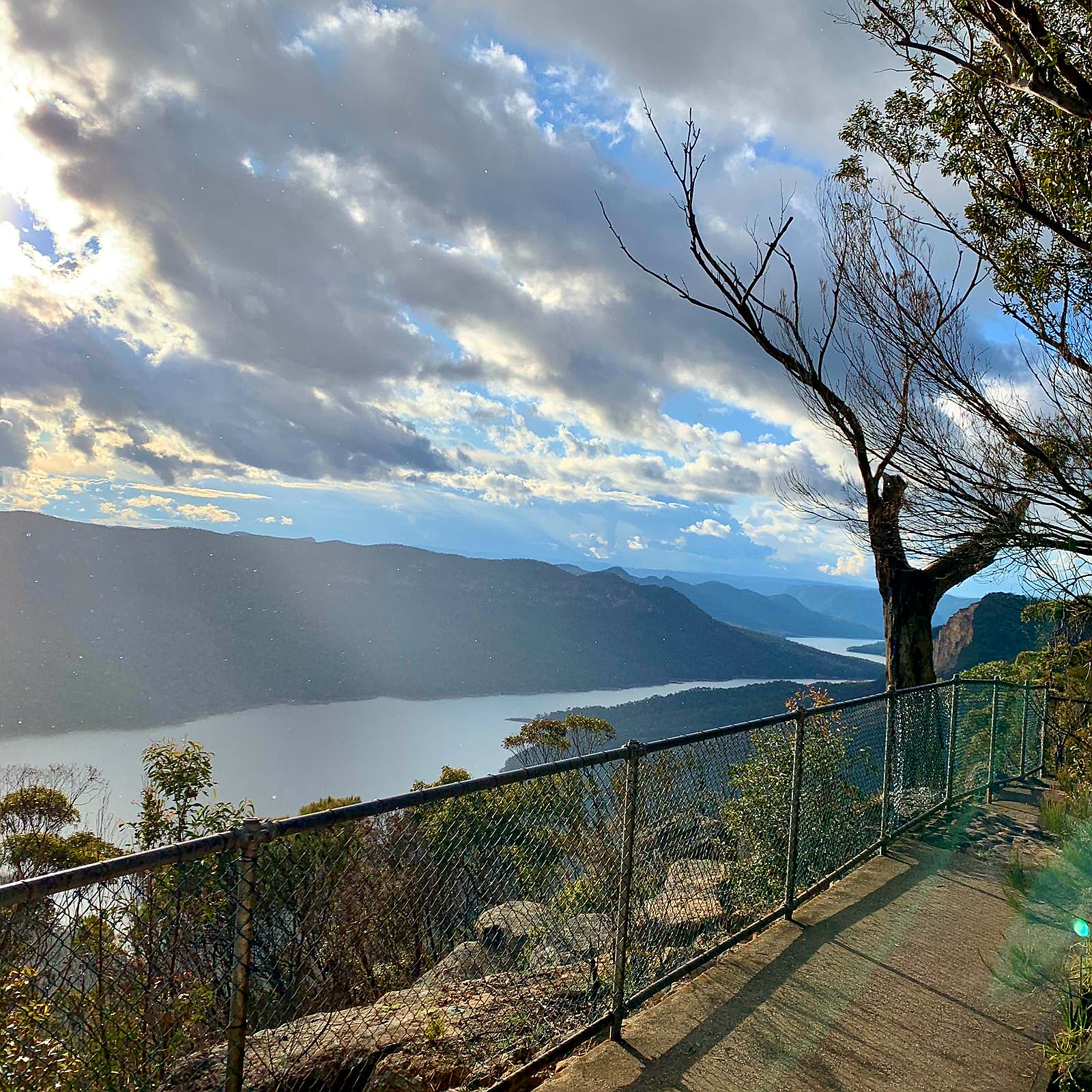
Burragorang or Burragorang Valley is a locality in the Macarthur Region of New South Wales, Australia, in Wollondilly Shire. It is home to Lake Burragorang, which is impounded by Warragamba Dam. It is located within the Blue Mountains National Park – specifically the Nattai National Park. History In 1827, the town of ''Burragorang'' was established as a mining town and up to the 1960s was a major supplier of coal. Moreover, lead and silver had also been mined in the valley until about 1927. With the boom of Sydney's population after World War II, Warragamba Dam was constructed between 1948 and 1960 on the Warragamba River, inundating the Burragorang Valley, creating Lake Burragorang. Consequently, the town of Burragorang and others like it in the valley were lost under water. The area around Burragorang and Nattai had been home to numerous collieries from the 1920s to the 1990s, such as the Nattai-Bulli, Oakleigh, Wollondlly, Nattai North and Valley collieries. It is estima ... [...More Info...] [...Related Items...] OR: [Wikipedia] [Google] [Baidu] |
Macarthur, New South Wales
Macarthur is a region in the south-west of Sydney, in the state of New South Wales, Australia. The region includes the local government areas of the City of Campbelltown, Camden Council, and Wollondilly Shire. It covers an area of 3,067 square kilometres and has a population of close to 310,000 residents. The region geographically forms the foothills between the Blue Mountains and Southern Highlands regions. The region is bounded at the north by Glenfield; at the south by Yanderra; at the east by the town of Appin; and at the west by the hamlet Nattai. Most of the area is taken up by the semi-rural Wollondilly Shire; most of the population lives within the satellite city of Campbelltown and its surrounding suburbs. The region is one of the fastest-growing regions in the Sydney metropolitan area, with many new modern suburbs sprouting up in recent decades such as Glen Alpine, Macquarie Links, Harrington Park, Blair Athol, Mount Annan, Currans Hill, Englorie Park ... [...More Info...] [...Related Items...] OR: [Wikipedia] [Google] [Baidu] |
New South Wales
) , nickname = , image_map = New South Wales in Australia.svg , map_caption = Location of New South Wales in AustraliaCoordinates: , subdivision_type = Country , subdivision_name = Australia , established_title = Before federation , established_date = Colony of New South Wales , established_title2 = Establishment , established_date2 = 26 January 1788 , established_title3 = Responsible government , established_date3 = 6 June 1856 , established_title4 = Federation , established_date4 = 1 January 1901 , named_for = Wales , demonym = , capital = Sydney , largest_city = capital , coordinates = , admin_center = 128 local government areas , admin_center_type = Administration , leader_title1 = Monarch , leader_name1 = Charles III , leader_title2 = Governor , leader_name2 = Margaret Beazley , leader_title3 = Premier , leader_name3 = Dominic Perrottet (Liberal) , national_representation = Parliament of Australia , national_representation_type1 = Senat ... [...More Info...] [...Related Items...] OR: [Wikipedia] [Google] [Baidu] |
Wollondilly Shire
Wollondilly Shire is a periurban local government area adjacent to the south-western fringe of Sydney Sydney ( ) is the capital city of the state of New South Wales, and the most populous city in both Australia and Oceania. Located on Australia's east coast, the metropolis surrounds Sydney Harbour and extends about towards the Blue Mountain ..., parts of which fall into the Macarthur, New South Wales, Macarthur, Blue Mountains (New South Wales), Blue Mountains and Central Tablelands regions in the state of New South Wales, Australia. Wollondilly Shire was created by proclamation in the NSW Government Gazette on 7 March 1906, following the passing of the Local Government (Shires) Act 1905, and amalgamated with the Municipality of Picton on 1 May 1940. Wollondilly Shire is named after the Wollondilly River. The area is traversed by the Hume Highway and the Southern Highlands railway line, New South Wales, Southern Highlands railway line. Wollondilly Shire contains several ... [...More Info...] [...Related Items...] OR: [Wikipedia] [Google] [Baidu] |
Lake Burragorang
Lake Burragorang is a man-made reservoir in the lower Blue Mountains of New South Wales, Australia, serving as a major water supply for greater metropolitan Sydney. The dam impounding the lake, the Warragamba Dam, is located approximately southwest of the Sydney central business district. Lake Burragorang is within the World Heritage Site of the Greater Blue Mountains Area. The reservoir collects water from the converged flows of the Coxs, Kowmung, Nattai, Wingecarribee, Wollondilly, and Warragamba rivers and their associated tributaries, all within the Nepean and Hawkesbury River catchment. Pre-lake history Before the construction of the dam, Burragorang Valley had been inhabited by white settlers since the 19th century, and for thousands of years before, the Burragorang valley was part of the tribal lands of the Gundungarra nation, an indigenous tribe that called the Burragorang valley, along with the Blue Mountains and Megalong Valley, their tribal land. A number of ... [...More Info...] [...Related Items...] OR: [Wikipedia] [Google] [Baidu] |
Warragamba Dam
Warragamba Dam is a heritage-listed dam in the outer South Western Sydney suburb of Warragamba, New South Wales, Warragamba, Wollondilly Shire in New South Wales, Australia. It is a concrete gravity dam, which creates Lake Burragorang, the primary reservoir for water supply for the city of Sydney. The dam wall is located approximately W of Sydney central business district, 4½ km SW of the town of Wallacia, New South Wales, Wallacia, and 1 km NW of the village of Warragamba. The dam was devised as part of a collective engineering response to Sydney's critical water scarcity, water shortage during World War II and was originally known as the Warragamba Emergency Scheme. Constructed between 1948 and 1960, the dam created capacity for a reservoir of and is fed by a catchment area of . The surface area of the lake covers of the now-flooded Burragorang, New South Wales, Burragorang Valley. It was designed and built by the Sydney Water, Metropolitan Water Sewerage and Drainage Board ... [...More Info...] [...Related Items...] OR: [Wikipedia] [Google] [Baidu] |
Blue Mountains National Park
The Blue Mountains National Park is a protected national park that is located in the Blue Mountains region of New South Wales, in eastern Australia. The national park is situated approximately west of Sydney, and the park boundary is quite irregular as it is broken up by roads, urban areas and inholdings. Despite the name mountains, the area is an uplifted plateau, dissected by a number of larger rivers. The highest point in the park is Mount Werong at above sea level; while the low point is on the Nepean River at above sea level as it leaves the park. The national park is one of the eight protected areas that, in 2000, was inscribed to form part of the UNESCO World Heritagelisted Greater Blue Mountains Area. The Greater Blue Mountains was one of 15 World Heritage places included in the National Heritage List on 21 May 2007. The Blue Mountains National Park is the most central of the eight protected areas within the World Heritage Site and it forms part of the Great Div ... [...More Info...] [...Related Items...] OR: [Wikipedia] [Google] [Baidu] |
Nattai National Park
The Nattai National Park is a protected national park that is located in the Macarthur and Southern Highlands regions of New South Wales, in eastern Australia. It is situated approximately southwest of the Sydney central business district and primarily encompasses the valley of the Nattai River, which is surrounded by spectacular sandstone cliffs. Part of the Southern Highlands Shale Forest and Woodland, the park is covered in dry sclerophyll (hard leafed) forest – mostly eucalypt and has fairly frequent forest fires. It is largely an untouched wilderness area and receives very few visitors, as it has virtually no facilities and is fairly remote, despite its proximity to Sydney. The Nattai National Park is one of the eight protected areas that, in 2000, was inscribed to form part of the UNESCO World Heritage-listed Greater Blue Mountains Area. The Nattai National Park is the most southern of the eight protected areas within the World Heritage Site. The national park forms ... [...More Info...] [...Related Items...] OR: [Wikipedia] [Google] [Baidu] |
World War II
World War II or the Second World War, often abbreviated as WWII or WW2, was a world war that lasted from 1939 to 1945. It involved the vast majority of the world's countries—including all of the great powers—forming two opposing military alliances: the Allies and the Axis powers. World War II was a total war that directly involved more than 100 million personnel from more than 30 countries. The major participants in the war threw their entire economic, industrial, and scientific capabilities behind the war effort, blurring the distinction between civilian and military resources. Aircraft played a major role in the conflict, enabling the strategic bombing of population centres and deploying the only two nuclear weapons ever used in war. World War II was by far the deadliest conflict in human history; it resulted in 70 to 85 million fatalities, mostly among civilians. Tens of millions died due to genocides (including the Holocaust), starvation, ma ... [...More Info...] [...Related Items...] OR: [Wikipedia] [Google] [Baidu] |
Warragamba River
The Warragamba River, a river that is part of the Hawkesbury-Nepean catchment, is located in the Macarthur region of New South Wales, Australia. Course and features Formed through the confluence of the Coxs River and two minor tributaries, Warragamba River rises within Lake Burragorang and is the river on which Warragamba Dam is established, creating a large reservoir with total capacity of , that forms a major part of the water supply to greater metropolitan Sydney. The river descends , the majority of which is over the dam spillway, and then flows north into the Nepean River, north of the village of Warragamba, a course of approximately . Prior to the creation of Lake Burragorang, the Warragamba River would have been formed by the confluences of the Coxs, Nattai, and Wollondilly rivers in the Burragorang Valley. Downstream, the river flowed through a gorge that varied in width from to , and was in depth. It was this configuration which allowed a relatively short but hig ... [...More Info...] [...Related Items...] OR: [Wikipedia] [Google] [Baidu] |
Nattai, New South Wales
Nattai is a small village in the Macarthur Region of New South Wales, Australia, in the Wollondilly Shire Wollondilly Shire is a periurban local government area adjacent to the south-western fringe of Sydney, parts of which fall into the Macarthur, Blue Mountains and Central Tablelands regions in the state of New South Wales, Australia. Wollo .... References Localities in New South Wales Wollondilly Shire {{NewSouthWales-geo-stub ... [...More Info...] [...Related Items...] OR: [Wikipedia] [Google] [Baidu] |
Oil Shale
Oil shale is an organic-rich fine-grained sedimentary rock containing kerogen (a solid mixture of organic chemical compounds) from which liquid hydrocarbons can be produced. In addition to kerogen, general composition of oil shales constitutes inorganic substance and bitumens. Based on their deposition environment, oil shales are classified as marine, lacustrine and terrestrial oil shales. Oil shales differ from oil-''bearing'' shales, shale deposits that contain petroleum (tight oil) that is sometimes produced from drilled wells. Examples of oil-''bearing'' shales are the Bakken Formation, Pierre Shale, Niobrara Formation, and Eagle Ford Formation. Accordingly, shale oil produced from oil shale should not be confused with tight oil, which is also frequently called shale oil. Deposits of oil shale occur around the world, including major deposits in the United States. A 2016 estimate of global deposits set the total world resources of oil shale equivalent of of oil in place. ... [...More Info...] [...Related Items...] OR: [Wikipedia] [Google] [Baidu] |


.jpg)
-Location-Map.png)

