|
Buritizeiro
Buritizeiro is a municipality in the north of the Brazilian state of Minas Gerais. Its population in 2020 was 28,121 inhabitants in a total area of 7,226 km². It is a major producer of cattle and grains. Location Buritizeiro belongs to the Paracatu statistical microregion. The elevation of the municipal seat is 836 meters. It became a municipality in 1963. This municipality is located on the left bank of the São Francisco River, across the river from Pirapora. The distance to the capital, Belo Horizonte, is 365 km. Other distances are: * Pirapora: 6 km. * Montes Claros: 167 km. * Uberlândia: 480 km. Neighboring municipalities are: Pirapora, São Romão, Três Marias e João Pinheiro. The climate is humid sub-tropical with an average maximum of 30°C; a minimum of 16°C; and an annual average of 22°C. The economy The main economic activities are cattle raising and farming. The GDP was R$157,117,000 (2003). [...More Info...] [...Related Items...] OR: [Wikipedia] [Google] [Baidu] |
List Of Municipalities In Minas Gerais ...
This is a list of the municipalities in the state of Minas Gerais (MG), located in the Southeast Region of Brazil. Minas Gerais is divided into 853 municipalities, which are grouped into 66 microregions, which are grouped into 12 mesoregions. See also *Geography of Brazil *List of cities in Brazil {{South America topic, List of cities in 01 Minas Gerais Minas Gerais () is a state in Southeastern Brazil. It ranks as the second most populous, the third by gross domestic product (GDP), and the fourth largest by area in the country. The state's capital and largest city, Belo Horizonte (literally ... [...More Info...] [...Related Items...] OR: [Wikipedia] [Google] [Baidu] |
Lassance
Lassance is a Brazilian municipality located in the north of the state of Minas Gerais. In 2020 the population was 6,503 in a total area of 3,213 km². It became a municipality in 1953.IBGE Location and Distances Lassance is located on federal highway BR-496 at an elevation of 504 meters. It is south of the nearest population center, and north of Corinto. The municipality is crossed by the Rio das Velhas, a tributary of the . Neighboring m ...[...More Info...] [...Related Items...] OR: [Wikipedia] [Google] [Baidu] |
Pirapora
Pirapora is a Municipalities of Brazil, municipality in northcentral Minas Gerais in Brazil. The population is 56,640 (2020 est.) in an area of 550 km². The name Pirapora comes from the Tupi language, Tupi words for "fish" + "jump", referring to the piracema season when a mass migration of fishes ascends the São Francisco River to spawn. Location Pirapora belongs to its own statistical microregion. The elevation of the municipal seat is 472 meters. It became a municipality in 1912. This municipality is located on the right bank of the São Francisco River and is 340 km from the state capital. Neighboring municipalities are: Lagoa Grande, Minas Gerais, Lagoa Grande, Coromandel, Minas Gerais, Coromandel, Guarda-Mor, Lagamar and Paracatu, Minas Gerais, Paracatu. There are two districts, besides the municipal seat: Claro de Minas, 12 km. distant, and Vazamor, 32 km. distant. Microregion of Pirapora The statistical microregion of Pirapora includes 9 cities: Buriti ... [...More Info...] [...Related Items...] OR: [Wikipedia] [Google] [Baidu] |
Três Marias
Três Marias is a Brazilian Municipalities of Brazil, municipality΄ in northwestern Minas Gerais. In 2020 the population was 32,716 in a total area of 2,763 km2. Climate The climate is tropical semi-humid, with an annual average temperature of , and an average annual maximum of ; average annual minimum: ; average annual rainfall: . The altitude varies between .Prefeitura municipal Location Três Marias is located at the north end of one of the largest reservoir (water), reservoirs in Brazil—the Represa Três Marias—and is close to the dam which controls water entering the São Francisco (river), São Francisco river. The city lies on the important federal highway BR-040, which links Belo Horizonte to Brasília. Neighboring municipalities are: Buritizeiro, Lassance, (N), Felixlândia (S), Corint ...[...More Info...] [...Related Items...] OR: [Wikipedia] [Google] [Baidu] |
Poços De Caldas
Poços de Caldas is a municipality in the south of Minas Gerais state, Brazil, in the microregion of the same name. Its estimated population in 2020 was 168,641 inhabitants. The city is known for its hot springs. History Poços was founded in 1872. The region had been inhabited by the Cataguases Indians, who were expelled from their lands by the '' Bandeiras Unidas Paulistas'' during their quest for gold. The place was first called ''Freguesia de Nossa Senhora da Saúde das Águas de Caldas'' ("Parish of Our Lady of Health of Caldas Waters"). In 1874 it became a district, then, in 1875, it was elevated to the category of city. It became famous after the discovery of the hot springs, and many important people began to visit the spa in search of cures provided by the water. The name comes from Caldas da Rainha, a spa town in central Portugal. Geography It lies on the boundary of the state of São Paulo at 1186 meters elevation and is the main socio-economic nucleus of its regi ... [...More Info...] [...Related Items...] OR: [Wikipedia] [Google] [Baidu] |
Buriti
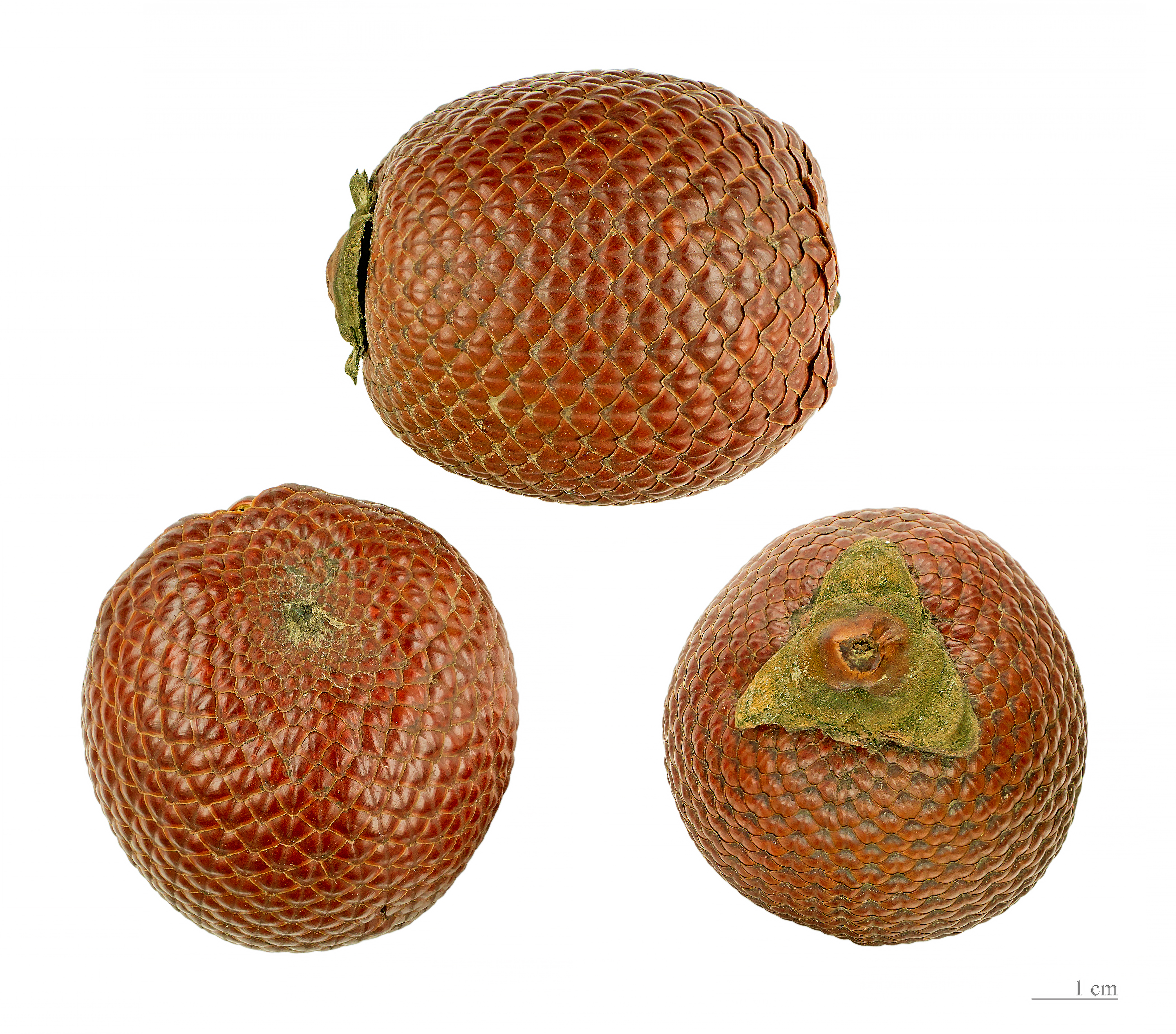
''Mauritia flexuosa'', known as the moriche palm, ''ité'' palm, ''ita'', ''buriti'', ''muriti'', ''miriti'' (Brazil), ''canangucho'' (Colombia), ''acho'' (Ecuador), or ''aguaje'' (Peru), is a palm tree. It grows in and near swamps and other wet areas in tropical South America. ''Mauritia flexuosa'', a tree, can reach up to in height. The large leaves form a rounded crown. The flowers are yellowish and appear from December to April. The fruit, which grows from December to June, is a chestnut color and is covered with shiny scales. The yellow flesh covers a hard, oval nut. The seeds float, and this is the means by which the palm tree propagates. In natural populations, the tree reaches very high densities. Fruit Moriche palm fruit ("morete" in the Oriente of Ecuador) is edible and used to make juice, jam, ice cream, a fermented "wine", desserts and snacks, requiring harvesting of more than 50 tonnes per day in Peru. The inflorescence buds are eaten as a vegetable and the sap c ... [...More Info...] [...Related Items...] OR: [Wikipedia] [Google] [Baidu] |
Várzea Da Palma
Várzea da Palma is a municipality ''(município)'' in north-central Minas Gerais in Brazil. Its population in 2020 was 39,803 in a total area of 2,220 km². Várzea da Palma is located east of the São Francisco River and is on the Rio das Velhas, a tributary of the São Francisco. It is 37 km. southeast of Pirapora, the most important city of the region. A railroad line, now only freight, runs through the city. Neighboring municipalities are Pirapora and Lassance. The former village of Palma Velha was a cluster of huts that served as a campsite for muleteers coming from different regions, on their way to Curvelo. With the building of the railroad Estrada de Ferro Central do Brasil, in 1910, the village changed its name to Várzea da Palma. Around the central station settlers began to make their houses attracted by commerce and the movement of the new railroad line. Custódio Fernandes Sampaio, considered the founder of the city, was responsible for donating part o ... [...More Info...] [...Related Items...] OR: [Wikipedia] [Google] [Baidu] |
Pará
Pará is a Federative units of Brazil, state of Brazil, located in northern Brazil and traversed by the lower Amazon River. It borders the Brazilian states of Amapá, Maranhão, Tocantins (state), Tocantins, Mato Grosso, Amazonas (Brazilian state), Amazonas and Roraima. To the northwest are the borders of Guyana and Suriname, to the northeast of Pará is the Atlantic Ocean. The capital and largest city is Belém, which is located at the mouth of the Amazon. The state, which is home to 4.1% of the Brazilian population, is responsible for just 2.2% of the Brazilian GDP. Pará is the most populous state of the North Region, Brazil, North Region, with a population of over 8.6 million, being the ninth-most populous state in Brazil. It is the second-largest state of Brazil in area, at , second only to Amazonas (Brazilian state), Amazonas upriver. Its most famous icons are the Amazon River and the Amazon Rainforest. Pará produces Natural rubber, rubber (extracted from natural rubber tree ... [...More Info...] [...Related Items...] OR: [Wikipedia] [Google] [Baidu] |
Belém
Belém (; Portuguese for Bethlehem; initially called Nossa Senhora de Belém do Grão-Pará, in English Our Lady of Bethlehem of Great Pará) often called Belém of Pará, is a Brazilian city, capital and largest city of the state of Pará in the country's north. It is the gateway to the Amazon River with a busy port, airport, and bus/coach station. Belém lies approximately 100 km upriver from the Atlantic Ocean, on the Pará River, which is part of the greater Amazon River system, separated from the larger part of the Amazon delta by ''Ilha de Marajó'' ( Marajo Island). With an estimated population of 1,499,641 people — or 2,491,052, considering its metropolitan area — it is the 11th most populous city in Brazil, as well as the 16th by economic relevance. It is the second largest in the North Region, second only to Manaus, in the state of Amazonas. Founded in 1616 by the Kingdom of Portugal, Belém was the first European colony on the Amazon but did not become ... [...More Info...] [...Related Items...] OR: [Wikipedia] [Google] [Baidu] |
Setubinha
Setubinha is a municipality in the northeast of the Brazilian state of Minas Gerais. As of 2020 the population was 12,378 in a total area of 536 km². The elevation is 729 metres. It is part of the IBGE statistical microregion of Teófilo Otoni The economy is based on cattle raising and agriculture, with the main crops being coffee, bananas, sugarcane, and corn. As of 2005 there were no hospitals and 3 public health clinics. In 2006 there were 14 primary schools and 2 middle schools. *List of municipalities in Minas Gerais This is a list of the municipalities in the state of Minas Gerais (MG), located in the Southeast Region of Brazil. Minas Gerais is divided into 853 municipalities, which are grouped into 66 microregions, which are grouped into 12 mesoregions. ... References External links IBGE Municipalities in Minas Gerais {{MinasGerais-geo-stub ... [...More Info...] [...Related Items...] OR: [Wikipedia] [Google] [Baidu] |


