|
Brünig-Napf-Reuss Line
The Brünig-Napf-Reuss line forms a geographical boundary in traditional Swiss culture ('' Kulturgrenze''). Running from the Brünig Pass along the Napf region to the Reuss (which joins the Aare at Brugg), it partly separates western (Bernese German) and eastern ( Zurich German) varieties of High Alemannic, although some places east of the line belong to the western dialect group (Schwyz, Zug). The line runs across the cantons of Lucerne and Aargau. The concept was first proposed by Richard Weiss in 1947, and it reflects the cultural situation in Switzerland as established by ethnographic field work during the early 20th century. Some historians and ethnographers argued that this cultural boundary is of greater importance historically than the French-German language boundary (the Röstigraben), even though it is widely admitted that the "line" doesn't form a sharp division but especially in its northern part is "fanning out" into a gradient. The line coincides, for example, with t ... [...More Info...] [...Related Items...] OR: [Wikipedia] [Google] [Baidu] |
High Alemannic German
High Alemannic is a dialect of Alemannic German spoken in the westernmost Austrian state of Vorarlberg and in Switzerland and Liechtenstein. Language area The High Alemannic dialects are spoken in Liechtenstein and in most of German-speaking Switzerland ( Swiss Plateau), except for the Highest Alemannic dialects in the Swiss Alps and for the Low Alemannic (Basel German) dialect in the North West. Therefore, High Alemannic must not be confused with the term "Swiss German", which refers to all Alemannic dialects of Switzerland as opposed to Swiss variant of Standard German, the literary language of diglossic German-speaking Switzerland. In Germany, High Alemannic dialects are spoken in Southern Baden-Württemberg, i.e. the Markgräflerland and in the adjacent area south of Freiburg im Breisgau up to the Black Forest ( Schönau). It is also spoken in the southern Sundgau region beyond the Upper Rhine, which is part of Alsace, France. In Vorarlberg in Western Austria, a fo ... [...More Info...] [...Related Items...] OR: [Wikipedia] [Google] [Baidu] |
Röstigraben
(; literally "Rösti ditch" or "Rösti trench" also transcribed in order to reflect the Swiss German pronunciation ) is a term used to refer to the cultural boundary between German-speaking and French-speaking parts of Switzerland, the latter known in French as the . There is also the term which refers to the boundary between German-speaking cantons and the Italian-speaking canton of Ticino. The term first appeared during World War I, when neutral Switzerland stood between the warring German Empire and the French Republic. Etymology The first part of the term is derived from the Swiss German name for hashed potatoes, , which originated in the canton of Bern and is considered typical of Swiss German cuisine. ''Graben'' has both the concrete and abstract meaning of "rift", with the Saane/Sarine river valley in the bilingual canton of Fribourg separating the linguistic areas. The Swiss-French use a similar expression: ''barrière de rös(ch)ti'', literally "rösti barrier", or ... [...More Info...] [...Related Items...] OR: [Wikipedia] [Google] [Baidu] |
Solothurn
, neighboring_municipalities = Bellach, Biberist, Feldbrunnen-Sankt Niklaus, Langendorf, Rüttenen, Zuchwil , twintowns = Heilbronn (Germany), Kraków (Poland), Le Landeron (Switzerland) Solothurn ( , ; french: Soleure ; it, Soletta ; rm, ) is a town, a municipality, and the capital of the canton of Solothurn in Switzerland. It is located in the north-west of Switzerland on the banks of the Aare and on the foot of the Weissenstein Jura mountains. The town is the only municipality of the district of the same name. The town got its name from Salodurum, a Roman-era settlement. From 1530 to 1792 it was the seat of the French ambassador to Switzerland. The pedestrian-only old town was built between 1530 and 1792 and shows an impressive array of Baroque architecture, combining Italian Grandezza, French style, and Swiss ideas. The town has eighteen structures listed as heritage sites. The official language of Solothurn is (the Swiss variety of Standard) German, but the mai ... [...More Info...] [...Related Items...] OR: [Wikipedia] [Google] [Baidu] |
Liestal
Liestal (, Standard ), formerly spelled Liesthal, is the capital of Liestal District and the canton of Basel-Landschaft in Switzerland, south of Basel. Liestal is an industrial town with a cobbled-street Old Town. The official language of Liestal is (the Swiss variety of Standard) German, but the main spoken language is the local variant of the Alemannic Swiss German dialect. History The name ''Liestal'' was first mentioned in 1225, and the settlement dates at least from Roman times. The development of the town is due to its strategic location on the road between the first bridge over the Rhine at Basel and the St. Gotthard Pass. Citizens of Liestal participated in the Burgundian Wars in 1476 and 1477 against Charles the Bold. In 1501, the mayor swore allegiance to the Swiss Confederation, and this caused repeated conflict with neighboring Rheinfelden, which belonged to the Habsburgs. In the 17th century, Liestal rebelled against Basel as part of the Farmers' Rebellion ... [...More Info...] [...Related Items...] OR: [Wikipedia] [Google] [Baidu] |
Bern
Bern () or Berne; in other Swiss languages, gsw, Bärn ; frp, Bèrna ; it, Berna ; rm, Berna is the ''de facto'' capital of Switzerland, referred to as the " federal city" (in german: Bundesstadt, link=no, french: ville fédérale, link=no, it, città federale, link=no, and rm, citad federala, link=no). According to the Swiss constitution, the Swiss Confederation intentionally has no "capital", but Bern has governmental institutions such as the Federal Assembly and Federal Council. However, the Federal Supreme Court is in Lausanne, the Federal Criminal Court is in Bellinzona and the Federal Administrative Court and the Federal Patent Court are in St. Gallen, exemplifying the federal nature of the Confederation. With a population of about 133,000 (as of 2022), Bern is the fifth-most populous city in Switzerland, behind Zurich, Geneva, Basel and Lausanne. The Bern agglomeration, which includes 36 municipalities, had a population of 406,900 in 2014. The metropolitan ... [...More Info...] [...Related Items...] OR: [Wikipedia] [Google] [Baidu] |
Aarau
Aarau (, ) is a town, a municipality, and the capital of the northern Swiss canton of Aargau. The town is also the capital of the district of Aarau. It is German-speaking and predominantly Protestant. Aarau is situated on the Swiss plateau, in the valley of the Aare, on the river's right bank, and at the southern foot of the Jura Mountains, and is west of Zürich, south of Basel and northeast of Bern. The municipality borders directly on the canton of Solothurn to the west. It is the largest town in Aargau. At the beginning of 2010 Rohr became a district of Aarau. The official language of Aarau is (the Swiss variety of Standard) German, but the main spoken language is the local variant of the Alemannic Swiss German dialect. Geography and geology The old city of Aarau is situated on a rocky outcrop at a narrowing of the Aare river valley, at the southern foot of the Jura mountains. Newer districts of the city lie to the south and east of the outcrop, as well as higher ... [...More Info...] [...Related Items...] OR: [Wikipedia] [Google] [Baidu] |
Zürich
, neighboring_municipalities = Adliswil, Dübendorf, Fällanden, Kilchberg, Maur, Oberengstringen, Opfikon, Regensdorf, Rümlang, Schlieren, Stallikon, Uitikon, Urdorf, Wallisellen, Zollikon , twintowns = Kunming, San Francisco Zürich () is the largest city in Switzerland and the capital of the canton of Zürich. It is located in north-central Switzerland, at the northwestern tip of Lake Zürich. As of January 2020, the municipality has 434,335 inhabitants, the urban area 1.315 million (2009), and the Zürich metropolitan area 1.83 million (2011). Zürich is a hub for railways, roads, and air traffic. Both Zurich Airport and Zürich's main railway station are the largest and busiest in the country. Permanently settled for over 2,000 years, Zürich was founded by the Romans, who called it '. However, early settlements have been found dating back more than 6,400 years (although this only indicates human presence in the area and not the presence of a town that early). During ... [...More Info...] [...Related Items...] OR: [Wikipedia] [Google] [Baidu] |
Burgundy (region)
Burgundy (; french: link=no, Bourgogne ) is a historical territory and former Regions of France, administrative region and province of east-central France. The province was once home to the Duke of Burgundy, Dukes of Burgundy from the early 11th until the late 15th century. The capital of Dijon was one of the great European centres of art and science, a place of tremendous wealth and power, and Western Monasticism. In early Modern Europe, Burgundy was a focal point of courtly culture that set the fashion for European royal houses and their court. The Duchy of Burgundy was a key in the transformation of the Middle Ages toward early modern Europe. Upon the 9th-century partitions of the Kingdom of Burgundy, the lands and remnants partitioned to the Kingdom of France were reduced to a ducal rank by King Robert II of France in 1004. The House of Burgundy, a cadet branch of the House of Capet, ruled over a territory that roughly conformed to the borders and territories of the modern ... [...More Info...] [...Related Items...] OR: [Wikipedia] [Google] [Baidu] |
Marches
In medieval Europe, a march or mark was, in broad terms, any kind of borderland, as opposed to a national "heartland". More specifically, a march was a border between realms or a neutral buffer zone under joint control of two states in which different laws might apply. In both of these senses, marches served a political purpose, such as providing warning of military incursions or regulating cross-border trade. Marches gave rise to titles such as marquess (masculine) or marchioness (feminine) in England, ''marqués'' (masculine) and ''marquesa'' (feminine) in Spanish-speaker countries, as well as in the Catalan and Galician regions, ''marquês'' (masculine) and ''marquesa'' (feminine) in Portuguese-speaker countries, ''markesa'' (both masculine and feminine) in Euskadi, ''marquis'' (masculine) or ''marquise'' (feminine) in France and Scotland, margrave (german: Markgraf, lit=march count; masculine) or margravine (, feminine) in Germany, and corresponding titles in other Eur ... [...More Info...] [...Related Items...] OR: [Wikipedia] [Google] [Baidu] |
Argovia
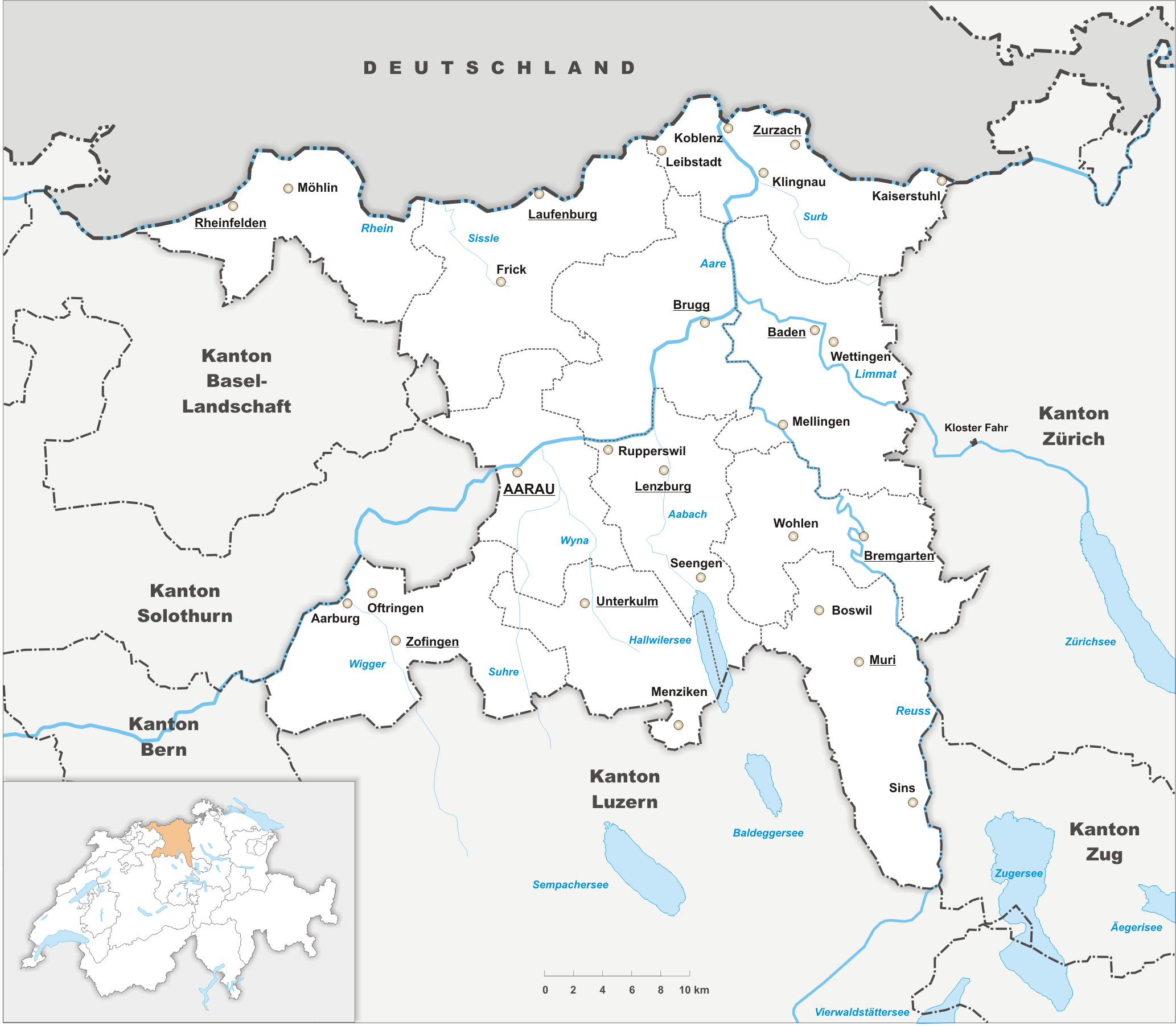
Aargau, more formally the Canton of Aargau (german: Kanton Aargau; rm, Chantun Argovia; french: Canton d'Argovie; it, Canton Argovia), is one of the 26 cantons forming the Swiss Confederation. It is composed of eleven districts and its capital is Aarau. Aargau is one of the most northerly cantons of Switzerland. It is situated by the lower course of the Aare River, which is why the canton is called ''Aar- gau'' (meaning "Aare province"). It is one of the most densely populated regions of Switzerland. History Early history The area of Aargau and the surrounding areas were controlled by the Helvetians, a member of the Celts, as far back as 200 BC. It was eventually occupied by the Romans and then by the 6th century, the Franks. The Romans built a major settlement called Vindonissa, near the present location of Brugg. Medieval Aargau The reconstructed Old High German name of Aargau is ''Argowe'', first unambiguously attested (in the spelling ''Argue'') in 795. The term ... [...More Info...] [...Related Items...] OR: [Wikipedia] [Google] [Baidu] |
Swiss Peasant War Of 1653
The Swiss peasant war of 1653 () was a popular revolt in the Old Swiss Confederacy at the time of the Ancien Régime. A devaluation of Bernese money caused a tax revolt that spread from the Entlebuch valley in the Canton of Lucerne to the Emmental valley in the Canton of Bern and then to the cantons of Solothurn and Basel and also to the Aargau. The population of the countryside demanded fiscal relief from their ruling authorities, the city councils of these cantons' capitals. When their demands were dismissed by the cities, the peasants organized themselves and threatened to blockade the cities. After initial compromises mediated by other cantons had failed, the peasants united under the treaty of Huttwil, forming the "League of Huttwil". Their movement became more radical, going beyond the initially purely fiscal demands. The Huttwil League considered itself a political entity equal to and independent from the city authorities, and it assumed full military and political so ... [...More Info...] [...Related Items...] OR: [Wikipedia] [Google] [Baidu] |


