|
Broadway–Nassau Street (IND Eighth Avenue Line)
The Fulton Street station is a major New York City Subway station complex in Lower Manhattan. It consists of four linked stations on the IND Eighth Avenue Line, the IRT Lexington Avenue Line, the BMT Nassau Street Line and the IRT Broadway–Seventh Avenue Line. The complex is served by the 2, 4, A, and J trains at all times. The 3, 5, and C trains stop here at all times except late nights, and the Z stops during rush hours in the peak direction. The complex comprises four stations, all named Fulton Street. The Lexington Avenue Line station was built for the Interborough Rapid Transit Company (IRT) as part of the city's first subway line, and opened on January 16, 1905. The Broadway–Seventh Avenue Line station, built for the IRT as part of the Dual Contracts, opened on July 1, 1918. The Brooklyn–Manhattan Transit Corporation (BMT)'s Nassau Street Line station was also built under the Dual Contracts and opened on May 29, 1931. The Independent Subway System (IND)'s ... [...More Info...] [...Related Items...] OR: [Wikipedia] [Google] [Baidu] |
Fulton Center
Fulton Center is a subway and retail complex centered at the intersection of Fulton Street and Broadway in Lower Manhattan, New York City. The complex was built as part of a $1.4 billion project by the Metropolitan Transportation Authority (MTA), a public agency of the state of New York, to rehabilitate the New York City Subway's Fulton Street station. The work involved constructing new underground passageways and access points into the complex, renovating the constituent stations, and erecting a large station building that doubles as a part of the Westfield World Trade Center mall. The project, first announced in 2002, was intended to improve access to and connections among the New York City Subway services stopping at the Fulton Street station. Funding for the construction project, which began in 2005, dried up for several years, with no final approved plan and no schedule for completion. Plans for the transit center were revived by the American Recovery and Reinvestment ... [...More Info...] [...Related Items...] OR: [Wikipedia] [Google] [Baidu] |
C (New York City Subway Service)
The C Eighth Avenue Local is a rapid transit service in the B Division of the New York City Subway. Its route emblem, or "bullet", is since it uses the IND Eighth Avenue Line in Midtown Manhattan. The C operates at all times except late nights between 168th Street in Washington Heights, Manhattan, and Euclid Avenue in East New York, Brooklyn, making all stops along its entire route. During late night hours, the train, which runs express along the entire C route during daytime hours, makes all stops. Historically, most C service ran only during rush hours, along the IND Concourse Line to Bedford Park Boulevard in the Bronx and later along the IND Rockaway Line to Rockaway Park–Beach 116th Street in Queens. Prior to 1985, the local C service was referred to as the CC, with the C designation reserved for a complementary express service that was discontinued in 1949. The CC was once the only route to serve the Bronx, Manhattan, Brooklyn, and Queens in a single trip. Outs ... [...More Info...] [...Related Items...] OR: [Wikipedia] [Google] [Baidu] |
Island Platform
An island platform (also center platform, centre platform) is a station layout arrangement where a single platform is positioned between two tracks within a railway station, tram stop or transitway interchange. Island platforms are popular on twin-track routes due to pragmatic and cost reasons. They are also useful within larger stations where local and express services for the same direction of travel can be provided from opposite sides of the same platform thereby simplifying transfers between the two tracks. An alternative arrangement is to position side platforms on either side of the tracks. The historical use of island platforms depends greatly upon the location. In the United Kingdom the use of island platforms is relatively common when the railway line is in a cutting or raised on an embankment, as this makes it easier to provide access to the platform without walking across the tracks. Advantages and tradeoffs Island platforms are necessary for any station with many th ... [...More Info...] [...Related Items...] OR: [Wikipedia] [Google] [Baidu] |
Side Platform
A side platform (also known as a marginal platform or a single-face platform) is a platform positioned to the side of one or more railway tracks or guideways at a railway station, tram stop, or transitway. A station having dual side platforms, one for each direction of travel, is the basic design used for double-track railway lines (as opposed to, for instance, the island platform where a single platform lies between the tracks). Side platforms may result in a wider overall footprint for the station compared with an island platform where a single width of platform can be shared by riders using either track. In some stations, the two side platforms are connected by a footbridge running above and over the tracks. While a pair of side platforms is often provided on a dual-track line, a single side platform is usually sufficient for a single-track line. Layout Where the station is close to a level crossing (grade crossing) the platforms may either be on the same side of the cross ... [...More Info...] [...Related Items...] OR: [Wikipedia] [Google] [Baidu] |
William Street (Manhattan)
William Street is a street in the Financial District of Lower Manhattan, New York City. It runs generally southwest to northeast, crossing Wall Street and terminating at Broad Street and Spruce Street, respectively. Between Beaver Street and Broad Street, the street is known as South William Street. Between Beekman Street and Spruce Street, in front of New York Downtown Hospital, William Street is a pedestrian-only street. History It is one of the oldest streets in Manhattan and can be seen in the 1660 Castello Plan of New Amsterdam. It was originally called King Street, but was later renamed William after Wilhelmus Beekman, Willem Beekman who arrived in New Amsterdam in 1647 as a fellow passenger of Peter Stuyvesant. Beekman got his start as a Dutch West India Company clerk and later served nine terms as mayor of the young port city. The buildings on South William Street 13-23 were reconstructed in the Dutch revival style by architect C. P. H. Gilbert and later Edwar ... [...More Info...] [...Related Items...] OR: [Wikipedia] [Google] [Baidu] |
Nassau Street (Manhattan)
Nassau Street is in the Financial District, within the borough of Manhattan in New York City. Its southern end is at the intersection with Broad Street and Wall Street, and its northern end is at Spruce Street, at Pace University near the foot of the Brooklyn Bridge. For its entire route, Nassau Street runs one block east of Broadway and Park Row. History Nassau Street was originally called Kip Street, after an early Dutch settler family, but was subsequently named in honor of the royal family of the Netherlands, the House of Orange-Nassau. It was named some time before William of Nassau, the Dutch prince who became King William III of England, so that is not the origin of the name, despite how easily it could be mistaken as such. Nassau Street once housed many of the city's newspapers. Late in the 20th century Nassau Street was closed to motor traffic during certain hours, in order to promote shopping. Nassau Street borders on the Fulton-Nassau Historic District, which ... [...More Info...] [...Related Items...] OR: [Wikipedia] [Google] [Baidu] |
Broadway (Manhattan)
Broadway () is a road in the U.S. state of New York (state), New York. Broadway runs from State Street (Manhattan), State Street at Bowling Green (New York City), Bowling Green for through the Boroughs of New York City, borough of Manhattan and through the Bronx, exiting north from New York City to run an additional through the Westchester County, New York, Westchester County municipalities of Yonkers, New York, Yonkers, Hastings-on-Hudson, New York, Hastings-On-Hudson, Dobbs Ferry, New York, Dobbs Ferry, Irvington, New York, Irvington, and Tarrytown, New York, Tarrytown, and terminating north of Sleepy Hollow, New York, Sleepy Hollow.There are four other streets named "Broadway" in New York City's remaining three boroughs: one each in Brooklyn (Broadway (Brooklyn), see main article) and Staten Island, and two in Queens (one running from Astoria, Queens, Astoria to Elmhurst, Queens, Elmhurst, and the other in Hamilton Beach, Queens, Hamilton Beach). Each borough therefore has ... [...More Info...] [...Related Items...] OR: [Wikipedia] [Google] [Baidu] |
Fulton Street (Manhattan)
Fulton Street is a busy street located in Lower Manhattan in New York City. Located in the Financial District, a few blocks north of Wall Street, it runs from West Street at the site of the World Trade Center to South Street, terminating in front of the South Street Seaport. The westernmost two blocks and the easternmost block are pedestrian streets. The street has a Beaux-Arts architectural feel with many buildings dating back to the Gilded Age or shortly thereafter. The early 19th-century buildings on the south side of the easternmost block are called Schermerhorn Row and are collectively listed on the National Register of Historic Places. History Regular cricket matches were held near the present Fulton Market in 1780 when the British Army-based itself in Manhattan during the American Revolution. The street itself was originally broken up into two parts, divided at Broadway. The eastern half was Fair Street and the western half was Partition Street. In 1816, both str ... [...More Info...] [...Related Items...] OR: [Wikipedia] [Google] [Baidu] |
Fare Control
In rail transport, the paid area is a dedicated "inner" zone in a railway station or metro station, accessible via turnstiles or other barriers, to get into which, visitors or passengers require a valid ticket, checked smartcard or a pass. A system using paid areas is often called fare control. Passengers are allowed to enter or exit only through a faregate. A paid area usually exists in rapid transit railway stations for separating the train platform from the station exit, ensuring a passenger has paid or prepaid before reaching the railway platform and using any transport service. Such design requires a well-organized railway station layout. In some systems, paid areas are named differently - for example, on railways in the United Kingdom they are called compulsory ticket areas The paid area is similar in concept to the airside at an airport. However, in most cases entrance to the paid area requires only a valid ticket or transit pass. The exception is in certain cases of inter ... [...More Info...] [...Related Items...] OR: [Wikipedia] [Google] [Baidu] |
Independent Subway System
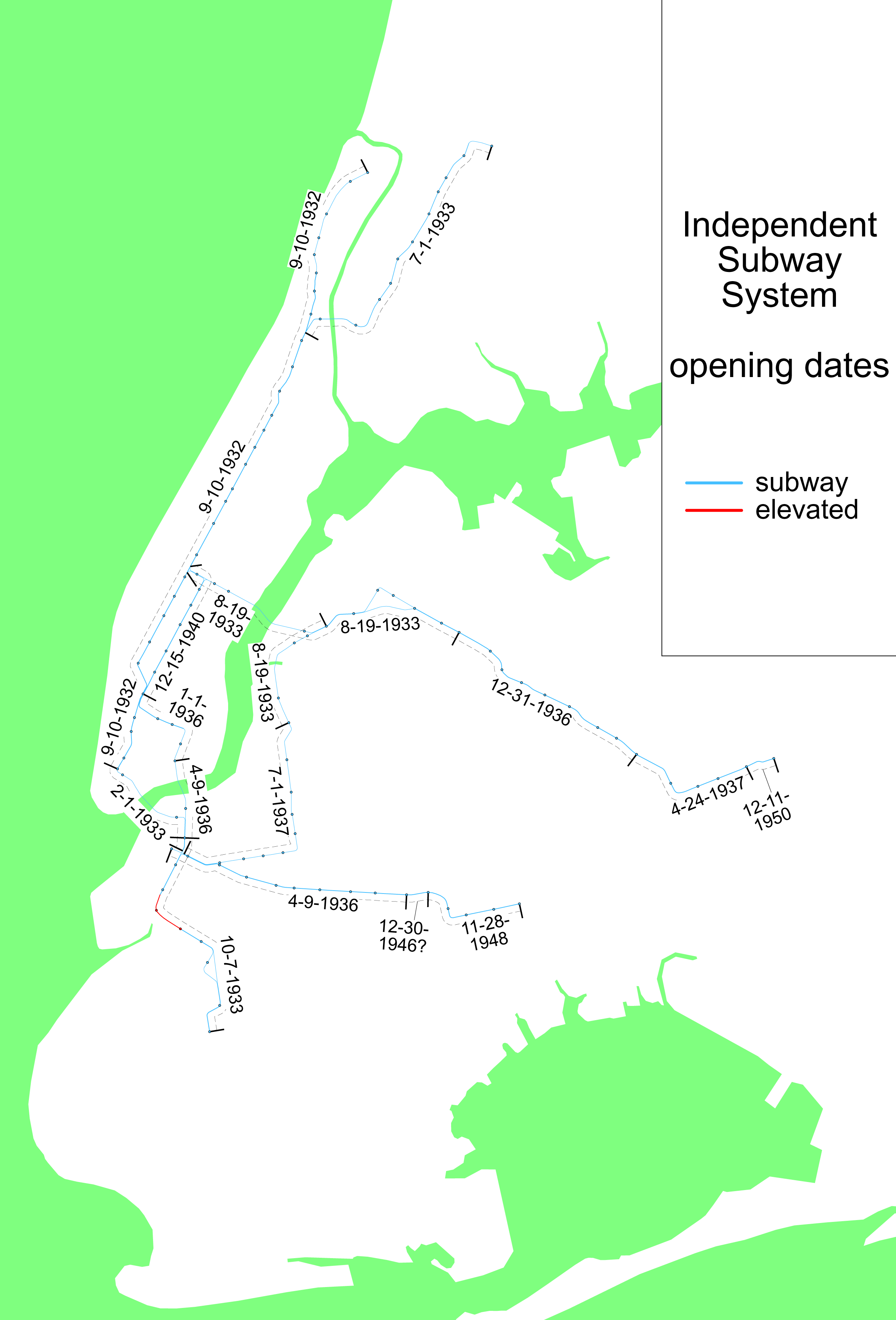
The Independent Subway System (IND or ISS), formerly known as the Independent City-Owned Subway System (ICOSS) or the Independent City-Owned Rapid Transit Railroad (ICORTR), was a rapid transit rail system in New York City that is now part of the New York City Subway. It was first constructed as the Eighth Avenue Line in Manhattan in 1932. One of three rail networks that became part of the modern New York City subway, the IND was intended to be fully owned and operated by the municipal government, in contrast to the privately operated or jointly funded Interborough Rapid Transit Company (IRT) and Brooklyn–Manhattan Transit Corporation (BMT) companies. It was merged with these two networks in 1940. The original IND service lines are the modern subway's A, B, C, D, E, F, and G services. In addition, the BMT's M, N, Q and R now run partly on IND trackage. The Rockaway Park Shuttle supplements the A service. For operational purposes, the IND and BMT lines and service ... [...More Info...] [...Related Items...] OR: [Wikipedia] [Google] [Baidu] |
Brooklyn–Manhattan Transit Corporation
The Brooklyn–Manhattan Transit Corporation (BMT) was an urban transit holding company, based in Brooklyn, New York City, United States, and incorporated in 1923. The system was sold to the city in 1940. Today, together with the IND subway system, it forms the B Division of the modern New York City Subway. The original BMT routes currently form the , , , , , and trains, as well as the Franklin Avenue Shuttle, with the IND , , and using BMT trackage in Brooklyn. The train enters the IND via the Chrystie Street Connection after crossing the Williamsburg Bridge, the , along with some rush-hour trains enter the IND from the BMT 63rd Street Line and the train enters the IND via the 60th Street Tunnel Connection. The train supplements the in the peak direction during rush hours only. Prior to city ownership, the BMT services were designed with numbers, and the current letter scheme was developed as a continuation of the IND nomenclature as the IND and BMT systems were in ... [...More Info...] [...Related Items...] OR: [Wikipedia] [Google] [Baidu] |
Dual Contracts
The Dual Contracts, also known as the Dual Subway System, were contracts for the construction and/or rehabilitation and operation of rapid transit lines in the City of New York. The contracts were signed on March 19, 1913, by the Interborough Rapid Transit Company and the Brooklyn Rapid Transit Company. As part of the Dual Contracts, the IRT and BRT would build or upgrade several subway lines in New York City, then operate them for 49 years. Most of the lines of the present-day New York City Subway were built or reconstructed under these contracts. The contracts were "dual" in that they were signed between the City and two separate private companies. Both the IRT and BRT (later Brooklyn–Manhattan Transit Corporation, or BMT) worked together to make the construction of the Dual Contracts possible. Background In the late 19th century and for most of the 20th century, New York was host to millions of immigrants each year. Many of the immigrants crowded into tenements and other ap ... [...More Info...] [...Related Items...] OR: [Wikipedia] [Google] [Baidu] |


