|
Bourne Eau
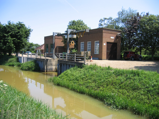
Bourne Eau is a short river which rises from an artesian spring in the town of Bourne in Lincolnshire, England, and flows in an easterly direction to join the River Glen at Tongue End. Within the town, it once powered three water mills, one of which is now a heritage centre. At Eastgate, it becomes much wider as it was navigable in the 18th and 19th centuries, and this was the location of the terminal basin. Below the town it is an embanked river, as its normal level is higher than that of the surrounding Fens. Navigation ceased in the 1860s and the river now forms an important part of the drainage system that enables the surrounding fen land to be used for agriculture. The artesian spring is fed by a limestone aquifer, which has been extensively used to supply drinking water to the locality and to Spalding. After a period of low rainfall in the late 1980s, the spring and hence the upper river dried up completely. A remediation project was implemented in 1992/93 to repair wild b ... [...More Info...] [...Related Items...] OR: [Wikipedia] [Google] [Baidu] |
River Glen, Lincolnshire
The River Glen is a river in Lincolnshire, England with a short stretch passing through Rutland near Essendine. The river's name appears to derive from a Brythonic Celtic language but there is a strong early English connection. Naming In the language of the Ancient Britons, which survives today as Welsh, Cornish and Breton, the neighbouring rivers, the Glen and the Welland seem to have been given contrasting names. The Welland flowed from the area underlain by the Northampton Sands which in many places are bound together by iron oxide to form ironstone. In the Roman period, the sands were easily worked as arable land and the ironstone was dug for smelting. In both cases, the ground was exposed to erosion which meant that silt was carried down to The Fens by the river. In modern Welsh, ''gwaelod'' (from Late Proto-British ''*Woelǫd-'') means bottom and its plural, ''gwaelodion'' means sediment. Among the medieval forms of the name 'Welland' is Weolod; the river could have th ... [...More Info...] [...Related Items...] OR: [Wikipedia] [Google] [Baidu] |
The Fens
The Fens, also known as the , in eastern England are a naturally marshy region supporting a rich ecology and numerous species. Most of the fens were drained centuries ago, resulting in a flat, dry, low-lying agricultural region supported by a system of drainage channels and man-made rivers ( dykes and drains) and automated pumping stations. There have been unintended consequences to this reclamation, as the land level has continued to sink and the dykes have been built higher to protect it from flooding. Fen is the local term for an individual area of marshland or former marshland. It also designates the type of marsh typical of the area, which has neutral or alkaline water and relatively large quantities of dissolved minerals, but few other plant nutrients. The Fens are a National Character Area, based on their landscape, biodiversity, geodiversity and economic activity. The Fens lie inland of the Wash, and are an area of nearly in Lincolnshire, Cambridgeshire, and Norfol ... [...More Info...] [...Related Items...] OR: [Wikipedia] [Google] [Baidu] |
Richard Tangye
Sir Richard Trevithick Tangye (24 November 183314 October 1906) was a British manufacturer of engines and other heavy equipment. Biography Richard Tangye was born at Illogan, near Redruth, Cornwall, the fifth son in a family of six sons and three daughters of Joseph Tangye (1798-1854), a Quaker miner of Redruth, later a small shopkeeper and farmer, and Ann, née Bullock. As a young boy he worked in the fields, but when he was eight years old he was incapacitated from further manual labour by a fracture of the right arm. His father then determined to give him the best education he could afford, and young Tangye was sent to the Quaker Sidcot School in the Mendip Hills near the village of Winscombe, Somerset, where he progressed rapidly and became a pupil-teacher. Career Tangye disliked this role, and through an advertisement in '' The Friend'' obtained a clerkship in a small engineering firm in Birmingham, where two of his brothers, skilled mechanics, subsequently joined him. Here ... [...More Info...] [...Related Items...] OR: [Wikipedia] [Google] [Baidu] |
Butterley Company
The Butterley Company was an English manufacturing firm founded as Benjamin Outram and Company in 1790. Its subsidiaries existed until 2009. Origins This area of Derbyshire had been known for its outcrops of iron ore which had been exploited at least since the Middle Ages. After the Norman Conquest, nearby Duffield Frith was the property of the de Ferrers family who were iron masters in Normandy. In 1793, William Jessop, with the assistance of Benjamin Outram, constructed the Cromford Canal to connect Pinxton and Cromford with the Erewash Canal. In digging Butterley Tunnel for the Cromford Canal, coal and iron were discovered. Fortuitously, Butterley Hall fell vacant and in 1790 Outram, with the financial assistance of Francis Beresford, bought it and its estate. The following year Outram and Beresford were joined by Jessop and John, the grandson of Ichabod Wright, a wealthy Nottingham banker who was betrothed to Beresford's daughter and who owned the neighbouring Butter ... [...More Info...] [...Related Items...] OR: [Wikipedia] [Google] [Baidu] |
Pumping Stations, Bourne South Fen, Lincs - Geograph
Pumping may refer to: * The operation of a pump, for moving a liquid from one location to another **The use of a breast pump for extraction of milk * Pumping (audio), a creative misuse of dynamic range compression * Pumping (computer systems), the number of times data is transmitted per clock cycle * Pumping (oil well), injecting chemicals into a wellbore * Pumping (noise reduction), an unwanted artifact of some noise reduction systems * Pumping lemma, in the theory of formal languages * Gastric lavage, cleaning the contents of the stomach * Optical pumping, in which light is used to raise electrons from a lower energy level to a higher one * Pump (skateboarding) {{single source, date=February 2019 Pumping is a skateboarding technique used to accelerate without the rider's feet leaving the board. Pumping can be done by turning or on a transition, like a ramp or quarter pipe.https://skateboarding.transworl ..., accelerating without pushing off of the ground * "Pumping" (My Heart) ... [...More Info...] [...Related Items...] OR: [Wikipedia] [Google] [Baidu] |
National Rivers Authority
The National Rivers Authority (NRA) was one of the forerunners of the Environment Agency of England and Wales, existing between 1989 and 1996. Before 1989 the regulation of the aquatic environment had largely been carried out by the ten regional water authorities (RWAs). The RWAs were responsible for the supply and distribution of drinking water, sewerage and sewage disposal, land drainage and flood risk management, fisheries, water quality management, pollution prevention, water resource management and many aspects of the management of aquatic ecology and some aspects of recreation. With the passing of the Water Act 1989, the ten water authorities in England and Wales were privatised by flotation on the stock market. They took the water supply, sewerage and sewage disposal activities into the privatised companies. The remaining duties remained with the newly created National Rivers Authority. The assets and the staff of the RWAs were divided up at privatisation between th ... [...More Info...] [...Related Items...] OR: [Wikipedia] [Google] [Baidu] |
Rutland Water
Rutland Water is a reservoir in Rutland, England, east of Rutland's county town, Oakham. It is filled by pumping from the River Nene and River Welland, and provides water to the East Midlands. By surface area it is the largest reservoir in England, but its capacity is exceeded by that of Kielder Water in Northumberland. Its maximum depth is 33m (108 ft). Set in of countryside, it has a perimeter track, ( excluding Hambleton Peninsula) for walking or cycling. Since the water is drawn upon when needed, the relative areas of land and water vary a little, but the flatter parts of the lake margin are enclosed by banks so that the wetland nature reserve is maintained (). A 1,555 hectare area of lake and shore is a biological Site of Special Scientific Interest, a Special Protection Area under the European Union Directive on the Conservation of Wild Birds and Nature Conservation Review site. An area of 1,333 hectares is a Ramsar internationally important wetland site, and 393 he ... [...More Info...] [...Related Items...] OR: [Wikipedia] [Google] [Baidu] |
Water Resources Act 1963
The Water Resources Act 1963 (1963 c.38) is an Act of the Parliament of the United Kingdom that continued the process of creating an integrated management structure for water, which had begun with the passing of the Land Drainage Act 1930. It created river authorities and a Water Resources Board. River authorities were responsible for conservation, re-distribution and augmentation of water resources in their area, for ensuring that water resources were used properly in their area, or were transferred to the area of another river authority. The river authorities covered the areas of one or more of the river boards created under the River Boards Act 1948, and inherited their duties and responsibilities, including those concerned with fisheries, the prevention of pollution, and the gauging of rivers. It did not integrate the provision of public water supply into the overall management of water resources, but it introduced a system of charges and licenses for water abstraction, wh ... [...More Info...] [...Related Items...] OR: [Wikipedia] [Google] [Baidu] |
Peterborough
Peterborough () is a cathedral city in Cambridgeshire, east of England. It is the largest part of the City of Peterborough unitary authority district (which covers a larger area than Peterborough itself). It was part of Northamptonshire until 1974, when county boundary change meant the city became part of Cambridgeshire instead. The city is north of London, on the River Nene which flows into the North Sea to the north-east. In 2020 the built-up area subdivision had an estimated population of 179,349. In 2021 the Unitary Authority area had a population of 215,671. The local topography is flat, and in some places, the land lies below sea level, for example in parts of the Fens to the east and to the south of Peterborough. Human settlement in the area began before the Bronze Age, as can be seen at the Flag Fen archaeological site to the east of the current city centre, also with evidence of Roman occupation. The Anglo-Saxon period saw the establishment of a monastery, Medeshams ... [...More Info...] [...Related Items...] OR: [Wikipedia] [Google] [Baidu] |
Domesday Book
Domesday Book () – the Middle English spelling of "Doomsday Book" – is a manuscript record of the "Great Survey" of much of England and parts of Wales completed in 1086 by order of King William I, known as William the Conqueror. The manuscript was originally known by the Latin name ''Liber de Wintonia'', meaning "Book of Winchester", where it was originally kept in the royal treasury. The '' Anglo-Saxon Chronicle'' states that in 1085 the king sent his agents to survey every shire in England, to list his holdings and dues owed to him. Written in Medieval Latin, it was highly abbreviated and included some vernacular native terms without Latin equivalents. The survey's main purpose was to record the annual value of every piece of landed property to its lord, and the resources in land, manpower, and livestock from which the value derived. The name "Domesday Book" came into use in the 12th century. Richard FitzNeal wrote in the ''Dialogus de Scaccario'' ( 1179) that the book ... [...More Info...] [...Related Items...] OR: [Wikipedia] [Google] [Baidu] |
Boston, Lincolnshire
Boston is a market town and inland port in the borough of the same name in the county of Lincolnshire, England. Boston is north of London, north-east of Peterborough, east of Nottingham, south-east of Lincoln, south-southeast of Hull and north-west of Norwich. Boston is the administrative centre of the wider Borough of Boston local government district. The town had a population of 35,124 at the 2001 census, while the borough had a population of 66,900 at the ONS mid-2015 estimates. Boston's most notable landmark is St Botolph's Church ("The Stump"), the largest parish church in England, which is visible from miles away across the flat lands of Lincolnshire. Residents of Boston are known as Bostonians. Emigrants from Boston named several other settlements around the world after the town, most notably Boston, Massachusetts in the United States. Name The name "Boston" is said to be a contraction of "Saint Botolph's town", "stone", or "'" (Old English, Old Norse an ... [...More Info...] [...Related Items...] OR: [Wikipedia] [Google] [Baidu] |
The Haven, Boston
The Haven is the tidal river of the port of Boston, Lincolnshire in England. It provides access for shipping between Boston Deeps in The Wash and the town, particularly, the dock. It also serves as the outfall into the sea, of the River Witham and of several major land drains of the northern Fens of eastern England, which are known collectively as the Witham Navigable Drains. (). Physical and economic development The English settlers who arrived in The Wash, found tidal creeks which gave them entry to the habitable belt of land, inland from the salt-marshes. These creeks, they called "havens". There was a route inland from The Haven, with which this article deals, on which Boston later developed, to the upland of Lindsey. However, the port of Boston did not develop until after natural events had diverted the River Witham into The Haven during the eleventh century. Simultaneously, this took the river away from Drayton, which had become the successor port of Swineshead as its ... [...More Info...] [...Related Items...] OR: [Wikipedia] [Google] [Baidu] |


.jpg)


