|
Boscastle To Widemouth
Boscastle to Widemouth is a coastal Site of Special Scientific Interest (SSSI) in Cornwall, England, noted for its biological and geological characteristics. The Dizzard dwarf oak woodland is unique and of international importance for its lichen communities, with 131 species recorded. Geography The site is located on the north Cornish coast, by the Celtic Sea of the Atlantic Ocean. The length of coastline stretches from Boscastle in the south to Widemouth Bay to the north.Ordnance Survey: Landranger map sheet 190 ''Bude & Clovelly'' The coast on either side of Crackington Haven is characterised by the cliffs collapsing and rather than having steep vertical slopes such as in west Cornwall, there is a series of 'undercliffs' which are thickly vegetated. Some are grazed by cattle and horses and the resulting mosaic of semi–natural habitats is of national importance for the coastal heath and grassland. High Cliff () at is the highest cliff in Cornwall. The South West Coast ... [...More Info...] [...Related Items...] OR: [Wikipedia] [Google] [Baidu] |
High Cliff, Cornwall
High may refer to: Science and technology * Height * High (atmospheric), a high-pressure area * High (computability), a quality of a Turing degree, in computability theory * High (tectonics), in geology an area where relative tectonic uplift took or takes place * Substance intoxication, also known by the slang description "being high" * Sugar high, a misconception about the supposed psychological effects of sucrose Music Performers * High (musical group), a 1974–1990 Indian rock group * The High, an English rock band formed in 1989 Albums * ''High'' (The Blue Nile album) or the title song, 2004 * ''High'' (Flotsam and Jetsam album), 1997 * ''High'' (New Model Army album) or the title song, 2007 * ''High'' (Royal Headache album) or the title song, 2015 * ''High'' (EP), by Jarryd James, or the title song, 2016 Songs * "High" (Alison Wonderland song), 2018 * "High" (The Chainsmokers song), 2022 * "High" (The Cure song), 1992 * "High" (David Hallyday song), 1988 * "H ... [...More Info...] [...Related Items...] OR: [Wikipedia] [Google] [Baidu] |
Shale
Shale is a fine-grained, clastic sedimentary rock formed from mud that is a mix of flakes of clay minerals (hydrous aluminium phyllosilicates, e.g. kaolin, Al2 Si2 O5( OH)4) and tiny fragments (silt-sized particles) of other minerals, especially quartz and calcite.Blatt, Harvey and Robert J. Tracy (1996) ''Petrology: Igneous, Sedimentary and Metamorphic'', 2nd ed., Freeman, pp. 281–292 Shale is characterized by its tendency to split into thin layers ( laminae) less than one centimeter in thickness. This property is called '' fissility''. Shale is the most common sedimentary rock. The term ''shale'' is sometimes applied more broadly, as essentially a synonym for mudrock, rather than in the more narrow sense of clay-rich fissile mudrock. Texture Shale typically exhibits varying degrees of fissility. Because of the parallel orientation of clay mineral flakes in shale, it breaks into thin layers, often splintery and usually parallel to the otherwise indistinguishable beddin ... [...More Info...] [...Related Items...] OR: [Wikipedia] [Google] [Baidu] |
Verrucaria Maura
''Hydropunctaria maura'' (still often called by the older name ''Verrucaria maura'') is a species of saxicolous (rock-dwelling), crustose lichen belonging to the family Verrucariaceae. A perennial species that does not experience seasonal variations, it is the type species of the genus ''Hydropunctaria''. The medulla is a black basal layer that forms columns ( Latin: ''punctae'') to the upper surface and isolates the algae into pockets near the upper surface. The black band formed by ''H. maura'' can often be seen at a distance as a marker of the high water point. Ecology ''Hydropunctaria maura'' is commonly found on hard rocks in the intertidal zone. Compared to terrestrial lichens, the species is typically located in areas of direct sunlight, suggests that it may have specific adaptations against damage from the sun. It is considered an upper littoral (supralittoral) lichen, compared to other, lower littoral lichens such as ''Wahlenbergiella mucosa'', distinguishe ... [...More Info...] [...Related Items...] OR: [Wikipedia] [Google] [Baidu] |
Splash Zone
In offshore construction, the splash zone is the transition from air to water when lowering heavy burdens into the sea. The overall efforts applied on the crane change dramatically when the load starts touching water, up to the point where it is completely submerged. Its buoyancy Buoyancy (), or upthrust, is an upward force exerted by a fluid that opposes the weight of a partially or fully immersed object. In a column of fluid, pressure increases with depth as a result of the weight of the overlying fluid. Thus the p ... reduces the static mass that the crane has to support, but contact with the waves creates widely fluctuating dynamic forces. Simulation of these changing efforts are necessary to correctly dimension cranes and lifting equipment. See for examplDNV-RP-H103(Det Norske Veritas recommended practices) for a mention of the piston effect created in the splash zone between two walls. Offshore engineering {{Engineering-stub ... [...More Info...] [...Related Items...] OR: [Wikipedia] [Google] [Baidu] |
Supralittoral Zone
The supralittoral zone, also known as the splash zone, spray zone or the supratidal zone, sometimes also referred to as the white zone, is the area above the spring high tide line, on coastlines and estuaries, that is regularly splashed, but not submerged by ocean water. Seawater penetrates these elevated areas only during storms with high tides.Thurman et al., p. 512. Organisms here must cope also with exposure to air, fresh water from rain, cold, heat and predation by land animals and seabirds. At the top of this area, patches of dark lichens can appear as crusts on rocks. Some types of periwinkles, Neritidae and detritus feeding Isopoda commonly inhabit the lower supralittoral.Yip and Madl See also *Littoral zone * Sublittoral zone Notes References * Thurman H.V. and Trujillo A.P. 1993.''Essentials of Oceanography''.Upper Saddle River, NJ:Prentice Hall * Yip, Maricela and Madl, Pierre (1999''Littoral''University of Salzburg The University of Salzburg (german: Universit� ... [...More Info...] [...Related Items...] OR: [Wikipedia] [Google] [Baidu] |
Plant Community
A plant community is a collection or association of plant species within a designated geographical unit, which forms a relatively uniform patch, distinguishable from neighboring patches of different vegetation types. The components of each plant community are influenced by soil type, topography, climate and human disturbance. In many cases there are several soil types present within a given plant community. This is because the soil type within an area is influenced by two factors, the rate at which water infiltrates or exits (via evapotranspiration) the soil, as well as the rate at which organic matter (any carbon-based compound within the environment, such as decaying plant matter) enters or decays from the soil. Plant communities are studied substantially by ecologists, due to providing information on the effects of dispersal, tolerance to environmental conditions, and response to disturbance of a variety of plant species, information valuable to the comprehension of various plant ... [...More Info...] [...Related Items...] OR: [Wikipedia] [Google] [Baidu] |
Millook
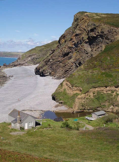
Millook is a deep coastal valley and hamlet in the parish of Poundstock, on the north coast of Cornwall, England. In 2014 the cliffs at Millook Haven were voted by the Geological Society of London as one of Britain's top 10 geological sites, leading the "folding and faulting" category. The cliffs display an impressive series of recumbent chevron folds, in Carboniferous age killas of inter-bedded sandstones and shales, originally deposited in deep water. The stony beach is popular with surfers despite there being few parking spaces and the South West Coast Path passes through the seaward end of the valley. The ancient semi-natural woodland has been described as the best ravine wood in Cornwall and along with the coast is within the Cornwall Area of Outstanding Natural Beauty. Millook Valley Woods The woodland runs roughly north-south from the A39 at Wainhouse Corner to the coast at Millook Haven. It consists of four separate properties now owned by the Woodland Tr ... [...More Info...] [...Related Items...] OR: [Wikipedia] [Google] [Baidu] |
Tundra
In physical geography, tundra () is a type of biome where tree growth is hindered by frigid temperatures and short growing seasons. The term ''tundra'' comes through Russian (') from the Kildin Sámi word (') meaning "uplands", "treeless mountain tract". There are three regions and associated types of tundra: Arctic tundra, alpine tundra, and Antarctic tundra. Tundra vegetation is composed of dwarf shrubs, sedges, grasses, mosses, and lichens. Scattered trees grow in some tundra regions. The ecotone (or ecological boundary region) between the tundra and the forest is known as the tree line or timberline. The tundra soil is rich in nitrogen and phosphorus. The soil also contains large amounts of biomass and decomposed biomass that has been stored as methane and carbon dioxide in the permafrost, making the tundra soil a carbon sink. As global warming heats the ecosystem and causes soil thawing, the permafrost carbon cycle accelerates and releases much of these soil-contained g ... [...More Info...] [...Related Items...] OR: [Wikipedia] [Google] [Baidu] |
Loess
Loess (, ; from german: Löss ) is a clastic, predominantly silt-sized sediment that is formed by the accumulation of wind-blown dust. Ten percent of Earth's land area is covered by loess or similar deposits. Loess is a periglacial or aeolian (windborne) sediment, defined as an accumulation of 20% or less of clay and a balance of roughly equal parts sand and silt (with a typical grain size from 20 to 50 micrometers), often loosely cemented by calcium carbonate. It is usually homogeneous and highly porous and is traversed by vertical capillaries that permit the sediment to fracture and form vertical bluffs. Properties Loess is homogeneous, porous, friable, pale yellow or buff, slightly coherent, typically non- stratified and often calcareous. Loess grains are angular, with little polishing or rounding, and composed of crystals of quartz, feldspar, mica and other minerals. Loess can be described as a rich, dust-like soil. Loess deposits may become very thick, more than ... [...More Info...] [...Related Items...] OR: [Wikipedia] [Google] [Baidu] |
Periglacial
Periglaciation (adjective: "periglacial", also referring to places at the edges of glacial areas) describes geomorphic processes that result from seasonal thawing of snow in areas of permafrost, the runoff from which refreezes in ice wedges and other structures. "Periglacial" suggests an environment located on the margin of past glaciers. However, freeze and thaw cycles influence landscapes outside areas of past glaciation. Therefore, periglacial environments are anywhere that freezing and thawing modify the landscape in a significant manner. Tundra is a common ecological community in periglacial areas. History Periglaciation became a distinct subject within the study of geology after Walery Łoziński, a Polish geologist, introduced the term in 1909. Łoziński drew upon the early work of Johan Gunnar Andersson. According to Alfred Jahn, his introduction of his work at the 1910 International Geological Congress held in Stockholm caused significant discussion. In the field trip ... [...More Info...] [...Related Items...] OR: [Wikipedia] [Google] [Baidu] |
Quaternary Period
The Quaternary ( ) is the current and most recent of the three period (geology), periods of the Cenozoic era (geology), Era in the geologic time scale of the International Commission on Stratigraphy (ICS). It follows the Neogene Period and spans from 2.58 million years ago to the present. The Quaternary Period is divided into two epochs: the Pleistocene (2.58 million years ago to 11.7 thousand years ago) and the Holocene (11.7 thousand years ago to today, although a third epoch, the Anthropocene, has been proposed but is not yet officially recognised by the ICS). The Quaternary Period is typically defined by the cyclic growth and decay of continental ice sheets related to the Milankovitch cycles and the associated climate and environmental changes that they caused. Research history In 1759 Giovanni Arduino (geologist), Giovanni Arduino proposed that the geological strata of northern Italy could be divided into four successive formations or "orders" ( it, quattro ord ... [...More Info...] [...Related Items...] OR: [Wikipedia] [Google] [Baidu] |
Variscan Orogeny
The Variscan or Hercynian orogeny was a geologic mountain-building event caused by Late Paleozoic continental collision between Euramerica (Laurussia) and Gondwana to form the supercontinent of Pangaea. Nomenclature The name ''Variscan'', comes from the Medieval Latin name for the district '' Variscia'', the home of a Germanic tribe, the Varisci; Eduard Suess, professor of geology at the University of Vienna, coined the term in 1880. (Variscite, a rare green mineral first discovered in the Vogtland district of Saxony in Germany, which is in the Variscan belt, has the same etymology.) ''Hercynian'', on the other hand, derives from the Hercynian Forest. Both words were descriptive terms of strike directions observed by geologists in the field, ''variscan'' for southwest to northeast, ''hercynian'' for northwest to southeast. The ''variscan'' direction reflected the direction of ancient fold belts cropping out throughout Germany and adjacent countries and the meaning shifted from d ... [...More Info...] [...Related Items...] OR: [Wikipedia] [Google] [Baidu] |


