|
Boles Fire
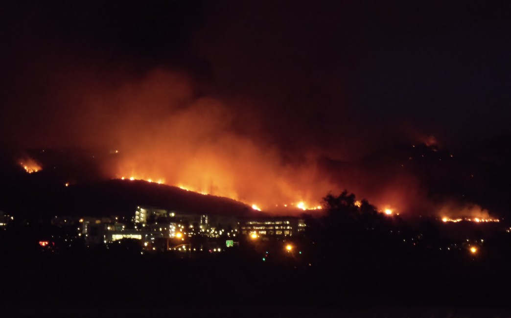
The Boles Fire was a wildfire that burned in Siskiyou County during mid-September 2014. On September 15, at 1:38 p.m. PDT, the Boles Fire ignited near Weed, California. Later on the same day, at 10:30 p.m. PDT, the Boles Fire was reported at 350 acres and 15% containment. Over 100 structures were reported damaged or destroyed on that day. Later that day, the wildfire was reported at nearly 100% containment; however, this report turned out to be erroneous. On September 16, the Boles Fire had burned 375 acres (152 ha) and was only 20% contained. It also destroyed 150 residences and forced the evacuation of 1,500 people in Weed and Siskiyou County Siskiyou County (, ) is a county in the northernmost part of the U.S. state of California. As of the 2020 census, the population was 44,076. Its county seat is Yreka and its highest point is Mount Shasta. It falls within the Cascadia bioregion .... During the next couple of days, the Boles Fire increased to , before finally being ... [...More Info...] [...Related Items...] OR: [Wikipedia] [Google] [Baidu] |
Mount Shasta
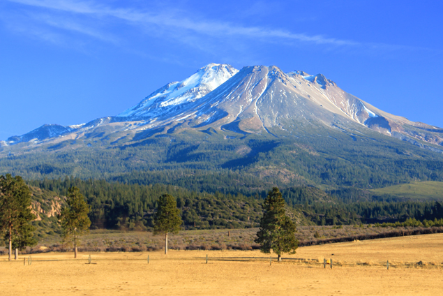
Mount Shasta ( Shasta: ''Waka-nunee-Tuki-wuki''; Karuk: ''Úytaahkoo'') is a potentially active volcano at the southern end of the Cascade Range in Siskiyou County, California. At an elevation of , it is the second-highest peak in the Cascades and the fifth-highest in the state. Mount Shasta has an estimated volume of , which makes it the most voluminous stratovolcano in the Cascade Volcanic Arc. The mountain and surrounding area are part of the Shasta–Trinity National Forest. Description Mount Shasta is connected to its satellite cone of Shastina, and together they dominate the landscape. Shasta rises abruptly to tower nearly above its surroundings. On a clear winter day, the mountain can be seen from the floor of the Central Valley to the south. The mountain has attracted the attention of poets, authors, and presidents. The mountain consists of four overlapping dormant volcanic cones that have built a complex shape, including the main summit and the prominent and visi ... [...More Info...] [...Related Items...] OR: [Wikipedia] [Google] [Baidu] |
Happy Camp Complex Fire
The Happy Camp Complex Fire was a massive wildfire that broke out on August 12, 2014, at 1:00 AM PDT, as a result of a lightning strikes in the Klamath National Forest in Northern California. The fire, which would eventually consume of land, was the largest fire of the 2014 California wildfire season and as of 2018, ranks 20th on the list of largest fires in state history. The wildfire During the first couple of weeks, the wildfire gradually expanded to . However, during the following 4 weeks, the wildfire quickly spread to by September 19, making the Happy Camp Complex the largest wildfire of the 2014 California wildfire season. The wildfire also ignited smaller spot fires to the northwest of the main fire, all the way up to a couple miles of the California-Oregon border. By September 21, the fire complex had reached 80% containment. On September 22, the Happy Camp Complex expanded to , but the containment remained at 85%. During the next 2 weeks, the Happy Camp Complex grad ... [...More Info...] [...Related Items...] OR: [Wikipedia] [Google] [Baidu] |
Weed, California
Weed is a city in Siskiyou County, California, United States. As of the 2020 Census, the city had a total population of 2,862, down from 2,967 in 2010. There are several unincorporated communities adjacent to, or just outside, Weed proper, including Edgewood, Carrick, and Lake Shastina. These communities generally have mailing addresses that use Weed or its ZIP code. Weed is about west-northwest of Mount Shasta, a prominent northern California landmark, and the second-tallest volcano in the Cascade Range. Weed's city motto is "Weed like to welcome you". Weed has frequently been noted on lists of unusual place names. History The City of Weed derives its name from the founder of the local lumber mill and pioneer Abner Weed, who discovered that the area's strong winds were helpful in drying lumber. In 1897, Abner Weed bought the Siskiyou Lumber and Mercantile Mill and of land in what is now the City of Weed, for $400. By the 1940s Weed boasted the world's largest sawmill. Bo ... [...More Info...] [...Related Items...] OR: [Wikipedia] [Google] [Baidu] |
Siskiyou County, California
Siskiyou County (, ) is a county in the northernmost part of the U.S. state of California. As of the 2020 census, the population was 44,076. Its county seat is Yreka and its highest point is Mount Shasta. It falls within the Cascadia bioregion. Siskiyou County is in the Shasta Cascade region along with the Oregon border. Because of its outdoor recreation, Mt. Shasta, McCloud River, and Gold Rush era history, it is an important tourist destination within the state. History Siskiyou County was created on March 22, 1852, from parts of Shasta and Klamath Counties, and named after the Siskiyou mountain range. Parts of the county's territory were given to Modoc County in 1855. The county is the site of the central section of the Siskiyou Trail, which ran between California's Central Valley and the Pacific Northwest. The Siskiyou Trail followed Native American footpaths, and was extended by Hudson's Bay Company trappers in the 1830s. Its length was increased by " Forty-Niners" ... [...More Info...] [...Related Items...] OR: [Wikipedia] [Google] [Baidu] |
Wildfire
A wildfire, forest fire, bushfire, wildland fire or rural fire is an unplanned, uncontrolled and unpredictable fire in an area of Combustibility and flammability, combustible vegetation. Depending on the type of vegetation present, a wildfire may be more specifically identified as a bushfire(bushfires in Australia, in Australia), desert fire, grass fire, hill fire, peat fire, prairie fire, vegetation fire, or veld fire. Fire ecology, Some natural forest ecosystems depend on wildfire. Wildfires are distinct from beneficial human usage of wildland fire, called controlled burn, controlled burning, although controlled burns can turn into wildfires. Fossil charcoal indicates that wildfires began soon after the appearance of terrestrial plants approximately 419 million years ago during the Silurian period. Earth's carbon-rich vegetation, seasonally dry climates, atmospheric oxygen, and widespread lightning and volcanic ignitions create favorable conditions for fires. The occurre ... [...More Info...] [...Related Items...] OR: [Wikipedia] [Google] [Baidu] |
California Department Of Forestry And Fire Protection
The California Department of Forestry and Fire Protection (CAL FIRE) is the fire department of the California Natural Resources Agency in the U.S. state of California. It is responsible for fire protection in various areas under state responsibility totaling 31 million acres, as well as the administration of the state's private and public forests. In addition, the department provides varied emergency services in 36 of the state's 58 counties via contracts with local governments. The department's current director is Joe Tyler, who was appointed March 4, 2022, by Governor of California Gavin Newsom. Operations CAL FIRE's foremost operational role is to fight and prevent wildfire on 31 million acres of state forestland. The organization works in both suppression and prevention capacities on state land, and offers emergency services of various kinds in 36 out of California's 58 counties, through contracts with local governments. The organization also assists in response to a wide ... [...More Info...] [...Related Items...] OR: [Wikipedia] [Google] [Baidu] |
2014 California Wildfires
2014 saw several notable wildfires igniting in California, especially during the month of May, when multiple fires were ablaze concurrently in Southern California, and during September, when several massive wildfires were burning in Northern California. In the context of the 2012–13 North American drought (especially the 2011–17 California drought), as well as powerful Santa Ana winds, weather conditions were ideal for wildfires. A total of 7,865 wildfires ignited throughout the year, which burned at least of land. The wildfires caused a total of 146 injuries and 2 fatalities, in addition to causing at least $204.05 million (2014 USD) in damage. The season began unusually early when a wildfire ignited on January 1, followed by 6 more fires igniting later within the same month. During a heat wave and dry Santa Ana conditions in May 2014, multiple wildfires broke out simultaneously in San Diego County, along with several other wildfires elsewhere in California. By mid-May, ... [...More Info...] [...Related Items...] OR: [Wikipedia] [Google] [Baidu] |


