|
Birkenhead Built-up Area
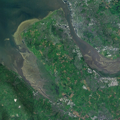
The Birkenhead Built-up area is an urban area in England, which covers the towns of Birkenhead, Wallasey, Bebington and Ellesmere Port in both Merseyside and Cheshire. It is defined for certain statistical purposes by NOMIS (National Online Manpower Information System), within the Office of National Statistics. The area is partly within the Metropolitan Borough of Wirral, and partly within the Cheshire West and Chester local authority. The definition includes suburbs in the eastern part of the Wirral Peninsula physically contiguous with the main urban areas (such as Moreton and Bromborough), but not physically separate towns and villages (such as Hoylake, Heswall, and Neston). The area was originally within the historic county of Cheshire Cheshire ( ) is a ceremonial and historic county in North West England, bordered by Wales to the west, Merseyside and Greater Manchester to the north, Derbyshire to the east, and Staffordshire and Shropshire to the south. Cheshire's cou ... [...More Info...] [...Related Items...] OR: [Wikipedia] [Google] [Baidu] |
List Of Urban Areas In The United Kingdom
This is a list of the most populous urban areas in the United Kingdom based on the United Kingdom Census 2011, 2011 census, as defined by the Office for National Statistics (ONS). Definition The methodology used by ONS in 2011 is set out in ''2011 Built-up Areas – Methodology and Guidance'', published in June 2013. When ONS reported the results of the 2011 UK census, it used the term "built-up area" rather than the term "urban area" as used in previous censuses. ONS states, however, that the criteria used to define "built-up area" have not changed: In reporting the United Kingdom Census 2001, 2001 census, ONS gave a clearer definition of the term "built-up" as follows: Most populous The list below shows the most populated urban areas in the United Kingdom as defined by the Office for National Statistics (ONS), but as readily referenced at Citypopulation.de. The list includes all urban areas with a population in excess of 100,000 at the 2011 census. Map See also *City ... [...More Info...] [...Related Items...] OR: [Wikipedia] [Google] [Baidu] |
Wirral Peninsula
Wirral (; ), known locally as The Wirral, is a peninsula in North West England. The roughly rectangular peninsula is about long and wide and is bounded by the River Dee to the west (forming the boundary with Wales), the River Mersey to the east, and the Irish Sea to the north. Historically, the Wirral was wholly in Cheshire; in the Domesday Book, its border with the rest of the county was placed at "two arrow falls from Chester city walls". However, since the Local Government Act 1972, only the southern third has been in Cheshire, with almost all the rest lying in the Metropolitan Borough of Wirral, Merseyside. An area of saltmarsh to the south-west of the peninsula lies in the Welsh county of Flintshire. The most extensive urban development is on the eastern side of the peninsula. The Wirral contains both affluent and deprived areas, with affluent areas largely in the west, south and north of the peninsula, and deprived areas concentrated in the east, especially Bir ... [...More Info...] [...Related Items...] OR: [Wikipedia] [Google] [Baidu] |
2011 United Kingdom Census
A census of the population of the United Kingdom is taken every ten years. The 2011 census was held in all countries of the UK on 27 March 2011. It was the first UK census which could be completed online via the Internet. The Office for National Statistics (ONS) is responsible for the census in England and Wales, the General Register Office for Scotland (GROS) is responsible for the census in Scotland, and the Northern Ireland Statistics and Research Agency (NISRA) is responsible for the census in Northern Ireland. The Office for National Statistics is the executive office of the UK Statistics Authority, a non-ministerial department formed in 2008 and which reports directly to Parliament. ONS is the UK Government's single largest statistical producer of independent statistics on the UK's economy and society, used to assist the planning and allocation of resources, policy-making and decision-making. ONS designs, manages and runs the census in England and Wales. In its capacity as t ... [...More Info...] [...Related Items...] OR: [Wikipedia] [Google] [Baidu] |
Neston
Neston is a town and civil parish on the Wirral Peninsula, in Cheshire, England. It is part of the unitary authority of Cheshire West and Chester. The village of Parkgate is located to the north west and the villages of Little Neston and Ness are to the south of Neston. At the 2001 census the population of Neston ward was recorded as 3,521, increasing to 4,329 at the 2011 census. The civil parish also includes Little Neston, Parkgate, Willaston and part of Burton and Ness, and had a population of 15,162 in 2001, increasing to 15,221 in 2011. History The name is of Viking origin, deriving from the Old Norse ''Nes-tún'', meaning 'farmstead or settlement at/near a promontory or headland'. Another Nesttun town can be found near Bergen, Norway. It is also mentioned in the Domesday Book as ''Nestone'' under the ownership of a William Fitznigel, with a population of eight households. Civic history A royal charter was granted to Neston in 1728 in support of its status as a ... [...More Info...] [...Related Items...] OR: [Wikipedia] [Google] [Baidu] |
Heswall
Heswall is a town on the Wirral, Merseyside, England. At the 2001 Census, the population was 16,012, including the nearby villages of Barnston and Gayton. Before local government reorganisation on 1 April 1974 it was part of the administrative county of Cheshire. Geography Located on the eastern side of the Dee Estuary, with views across the river to North Wales, Heswall is about 20 minutes' drive from the Roman city of Chester and about 20 minutes' drive from Liverpool. The towers of Liverpool's cathedrals can be seen on the horizon from high ground. History Early History Before the Norman Conquest The Norman Conquest (or the Conquest) was the 11th-century invasion and occupation of England by an army made up of thousands of Norman, Breton, Flemish, and French troops, all led by the Duke of Normandy, later styled William the Conq ..., Heswall has been cited as a possible location for Dingesmere, mentioned with regard to the Battle of Brunanburh, in ''E ... [...More Info...] [...Related Items...] OR: [Wikipedia] [Google] [Baidu] |
Hoylake
Hoylake is a coast, seaside town in the Metropolitan Borough of Wirral, Merseyside, England. It is at the north west of the Wirral Peninsula, near West Kirby and where the River Dee, Wales, River Dee meets the Irish Sea. Historic counties of England, Historically part of Cheshire, the Domesday Book of 1086 recorded it within the Hundreds of Cheshire, Hundred of Wilaveston. At the 2001 United Kingdom census, 2001 census, the population of Hoylake was 5,710 of a total population of 13,042, as part of the Hoylake and Meols (ward), Hoylake and Meols local government Ward (electoral subdivision), ward. By the time of the 2011 United Kingdom census, 2011 census specific population figures for Hoylake were no longer maintained. The total population for the Hoylake and Meols Ward at this census was 13,348. History In 1690, William III of England, William III set sail from Hoylake, then known as ''Hyle'' or ''High-lake'', with a 10,000-strong army to Ireland, where his army was to t ... [...More Info...] [...Related Items...] OR: [Wikipedia] [Google] [Baidu] |
Bromborough
Bromborough is a town within the Metropolitan Borough of Wirral, in Merseyside, England. Within the boundaries of the historic county of Cheshire, it is situated on the Wirral Peninsula, to the south east of Bebington and to the north of Eastham. In the 2001 census, the population of the township was 12,630, although the total number of people in the larger Bromborough Ward was 13,963. By the time of the 2011 census the population of the township was not recorded, although that of the ward was shown as having increased to 14,850. History The name ''Brunanburh'' is suggested to mean "Bruna's fortification", with ''burh'' being Old English for a fortified place. Bromborough is a contender for the site of an epic battle of 937, the Battle of Brunanburh, which confirmed England as a united Anglo-Saxon kingdom. In an article in ''Notes and Queries'' in 2022, Michael Deakin questions the philological case for Bromborough as ''Brunanburh'', suggesting that the first element i ... [...More Info...] [...Related Items...] OR: [Wikipedia] [Google] [Baidu] |
Moreton, Merseyside
Moreton is a town on the north coast of the Wirral Peninsula, Merseyside, England. It is located approximately to the west of Wallasey. Historically part of Cheshire, it is now within the Metropolitan Borough of Wirral. The town was divided in 2004 between the local government wards of Leasowe & Moreton East and Moreton West & Saughall Massie. Moreton is also part of the parliamentary constituency of Wallasey. In the 2001 census it had a population of 17,670. History Prior to the Norman conquest, the Lingham area of Moreton was a possible location for Dingesmere, mentioned with regard to the Battle of Brunanburh, in Egil's Saga. At the time of the Domesday Book, the area was a township in the parish of Bidston, within the Wirral Hundred. In the twelfth century, it formed part of the estates of Hamo de Mascy. The name Moreton was first recorded in 1278, as Meretun, and derives from Anglo-Saxon words meaning a settlement (''tun'') beside a lake (''mere''). The village join ... [...More Info...] [...Related Items...] OR: [Wikipedia] [Google] [Baidu] |
Cheshire West And Chester
Cheshire West and Chester is a Unitary authorities of England, unitary authority with Borough status in the United Kingdom, borough status in the ceremonial county of Cheshire, England. It was established on 1 April 2009 as part of the 2009 structural changes to local government in England, 2009 local government changes, by virtue of an order under the Local Government and Public Involvement in Health Act 2007. It superseded the boroughs of Ellesmere Port and Neston, Vale Royal and the Chester (district), City of Chester; its council assumed the functions and responsibilities of the former Cheshire County Council within its area. The remainder of ceremonial Cheshire is composed of Cheshire East, Borough of Halton, Halton and Borough of Warrington, Warrington. The decision to create the Cheshire West and Chester unitary authority was announced on 25 July 2007 following a consultation period, in which a proposal to create a single Cheshire unitary authority was rejected. Governan ... [...More Info...] [...Related Items...] OR: [Wikipedia] [Google] [Baidu] |
Birkenhead
Birkenhead (; cy, Penbedw) is a town in the Metropolitan Borough of Wirral, Merseyside, England; historically, it was part of Cheshire until 1974. The town is on the Wirral Peninsula, along the south bank of the River Mersey, opposite Liverpool. At the 2011 census, it had a population of 88,818. Birkenhead Priory and the Mersey Ferry were established in the 12th century. In the 19th century, Birkenhead expanded greatly as a consequence of the Industrial Revolution. Birkenhead Park and Hamilton Square were laid out as well as the first street tramway in Britain. The Mersey Railway connected Birkenhead and Liverpool with the world's first tunnel beneath a tidal estuary; the shipbuilding firm Cammell Laird and a seaport were established. In the second half of the 20th century, the town suffered a significant period of decline, with containerisation causing a reduction in port activity. The Wirral Waters development is planned to regenerate much of the dockland. Toponymy The ... [...More Info...] [...Related Items...] OR: [Wikipedia] [Google] [Baidu] |
Metropolitan Borough Of Wirral
The Metropolitan Borough of Wirral is a metropolitan borough of Merseyside, in North West England. It has a population of 321,238, and encompasses of the northern part of the Wirral Peninsula. Major settlements include Birkenhead, Wallasey, Bebington, Heswall, Hoylake and West Kirby. The city of Liverpool faces the northeastern side of Wirral over the Mersey. Geography Bordering is the River Mersey to the east, the Irish Sea to the north and the River Dee to the west; the borough of Cheshire West and Chester occupies the remainder of the Wirral Peninsula and borders the borough of Wirral to the south. The borough of Wirral has greater proportions of rural areas than the Liverpool part of Merseyside. History The borough was formed on 1 April 1974, under the Local Government Act 1972, as a merger of the county boroughs of Birkenhead and Wallasey, along with the municipal borough of Bebington and the urban districts of Hoylake and Wirral. Economy This is a chart of trend of ... [...More Info...] [...Related Items...] OR: [Wikipedia] [Google] [Baidu] |
Office Of National Statistics
An office is a space where an organization's employees perform administrative work in order to support and realize objects and goals of the organization. The word "office" may also denote a position within an organization with specific duties attached to it (see officer, office-holder, official); the latter is in fact an earlier usage, office as place originally referring to the location of one's duty. When used as an adjective, the term "office" may refer to business-related tasks. In law, a company or organization has offices in any place where it has an official presence, even if that presence consists of (for example) a storage silo rather than an establishment with desk-and-chair. An office is also an architectural and design phenomenon: ranging from a small office such as a bench in the corner of a small business of extremely small size (see small office/home office), through entire floors of buildings, up to and including massive buildings dedicated entirely to one ... [...More Info...] [...Related Items...] OR: [Wikipedia] [Google] [Baidu] |


.jpg)


